
 based on the text written by moweez
Introduction 
Welcome to this Wiki page. You probably got the advice from another editor to read this page, or a specific part of this page. This advice is given to increase the quality of your edits. The edits for which you were referenced might have been deleted or adjusted in the mean time. This might be inconvenient, because you miss a specific example. However, realize that the main goal of this advice is to improve your editing skills, while keeping the map up to date. If there is no specific subject that led to the referral of this Wiki page, just globally read the information. Once you need it, come back to the specific section of the subject. We advise you not to try to understand this whole Wiki page with all the details in one go, for it might be overwhelming.
Every editor has made mistakes and also everyone, now and then, still does. That's the way most people learn. And most of the times they are not even mistakes. The editing guidelines have developed over several years. So, something that was according to the regulations a year ago, might today be ready for improvement.
This Wiki page is not supposed to be a full manual of how to edit the Waze Map. It is an overview of subjects that are often confusing for starting editors, because they did not know the guidelines yet and their own logic tells them differently. This is not surprising because many of the guidelines have changed over the years and if you don't know the history, you don't always see the logic. All (starting) editors had this issue. And because guidelines are still changing and will keep changing, this will also happen to more experienced editors. In addition, the technical working of Waze changes often.
On this Wiki page, we have tried to combine technical knowledge of Waze with the users guidelines in the BeLux. To keep duplicate texts to a minimum, we also refer to other Wiki pages.
The best advice we can give to starting editors is to just start and make use of the community. Things will become clear in the process of learning. If something is unclear to you, first try to find it in one of the Wiki pages . If you can't find it, ask your community; Other editors are very willing to help. While reading the information in the Wiki or getting it from other editors, please keep in mind that, like in real life, also in Waze things are not always black and white. That is why we say we don't have rules or regulations, but guidelines. You may receive several opinions from two experienced editors and both can be correct, although a different interpretation. In addition, exceptions to guidelines are always possible and not a problem, provided you have good arguments.
Most mistakes are because of a misunderstanding of the overall principle: Waze is not a topographic map, but a navigation tool. Many starting editors try to make the map in Waze an exact copy of the actual situation. Roads are split; pedestrian boarding walks and cycle paths are added; perfect rounded corners and area places are exactly drawn. The actual goal of Waze is to get the best routing instructions. The less detail on the map, the easier and faster a map can be interpreted during driving, especially on small smartphone screens.
Another reason to keep the detail as low as possible is speed. The less details the less bandwidth the downloading of the map requires. Also the less junctions there are, the faster the route calculation is. The number of junctions that Waze can handle in one route is limited. So keeping the number of junctions as low as possible allows for a longer route.
To help you, Waze has created a number guidelines. That is what this page is about.
Editing mistakes are inevitable
Everybody, without the need of any prior knowledge or practice, can start editing the Waze map. Therefore, Waze accepts the risk that users make edits that seems logical to them, but lead to undesired results. The Waze community is enthousiastic and active, so the mistake will often quickly be noticed. A more experienced editor will contact you to correct the mistake or do the correction himself. It is not meant as criticism, but an encouragement to learn more about editing.
Mistakes are often the result of a misunderstood or unknown guideline, or a lack of technical knowledge. In fact, there is only one true "mistake" you can make, which is withholding from communication with other editors.
Make sure that other editors can contact you
The only true mistake you can make as an editor, is being unreachable to other editors. If editors spot your edits with an undesired result, or if they don't understand the reason why you made this edit, they will try to contact you. They want to increase the quality of the map and at the same time help you to become a better editor. If other editors cannot reach you, they cannot help you! Moreover, they will probably change your edits according to their own interpretation of the situation.
Therefore, make sure that you can receive e-mails from Waze by providing a valid mail address. Check your mailbox regularly. Also check whether e-mails from Waze are delivered to your spam- or junkfolder. You might want to add the sender to your address book, and make a filter to move the e-mails from Waze to a specific folder, or even create a separate mailbox for Waze. If needed, adjust your Waze settings.
Communication
How can I contact Waze? Where can I find more information? Where can I post my questions. The local champs are responsible for Waze in your local community. Please contact one of more of them for questions or assistance.
Slack
Slack© is a chat platform maintained by the community, and a good starting point for finding more information. You can meet other editors, read the latest information, learn from discussions, or ask a question. Please feel welcome to join by registering on Belux Slack. In Slack there are several Channels, Private groups, and you can send Direct Messages (DM). More about Slack is described on our Slack Wiki page.
Forum
The BeLux forum has less activity since we use Slack, and is mainly used for map modification requests and roadworks / closure requests. You can log in using your standard Waze login and password you use in the app and the editor. In the forum you can also make use of Private Messages (PM), this is a kind of inbox, like your e-mail. When you receive a PM you will also receive a regular e-mail to inform you of the new message. How you can handle your PM's you can read here.
Chat
When you are editing you can directly request help in Waze Map Editor/Chat. When asking for help you can see the level of the editor you are talking to. Please keep in mind that most editors are willing to help, but not all of them have the technical knowledge or editing experience to give you the best answer. Because the built-in chat does not always work as desired, we also have Slack.
Wiki
A lot of information is available in this BeLux Wiki. The guidelines are written in English, and we try to translate them into French and Dutch (Flamish) at least. If available, you can select a different language at the top of the page. You can always suggest updates in the Slack channel #team-wazeopedia. There is an extended page on Wiki as well.
Basic principles of Waze
Many misunderstandings have their origin in the fact that the fundamental principles of Waze are not always logical. Waze is developed for drivers of cars and motorcycles and should not be used for other means of transportation like pedestrians, pedal cyclists, or commercial transport. Also, Waze is not meant to include your personal favorite places, or illegal shortcuts.
Usability
When it comes to the map, the first and foremost goal of editing is to provide the driver with a map that is easy to follow on a small display, and to produce sensible verbal instructions when (and only when) they are needed.
Simplicity
It is not a goal to model the physical roadway lane-by-lane. Doing so often leads to unnecessary complexity - which means a cluttered map, confusing verbal directions, and lots and lots (and lots!) of extra map maintenance. Keep the map simple and effective. Detailed examples can be found on the KISS page.
Retention
As a result of people driving over them, road segments retain certain information (e.g., average speed) that is used in route optimization. When a segment is deleted, that information is deleted too. Given a choice between deleting a tangle of segments and creating new ones in their place, vs. untangling them and reusing them, it is often better to "recycle".
Another reason to be cautious with deleting segments is that another editor had a reason to add it. It can be very demotivating when someone just deletes work without any consultation. Everybody can make a mistake, or guidelines can be changed over time. Preferably consult the editor who added or edited the segment recently, rather than change the segment yourself.
Common functional problems
Incorrect or incomplete data can have a negative effect on the navigation or even make it impossible to navigate to a specific location. They should be corrected as soon as possible. These functional mistakes are, if noticed by an other editor, often directly corrected because of the great impact to the functionality of the App.
Unnamed roads


When a road does not have a city- or street name, it will get a red outline in WME and it won't be used for navigation. These roads can originate from:
- Paving roads, who have not been confirmed in the WME.
- an editor added a road, but forgot to give it a name.
Fill in the city and street name by selecting the segment, than click in the top left of the menu. If you don't know the name of the street or the city, check None.
Before you delete a segment, first consult the editor who added it. If you think the segment is an improvement to the map, fill in the missing data. Also check the junction arrows; when an editor has forgotten to fill in the name, probably the junction arrows are not set either.
Read more information in: Create a road.
Disconnected segments
Even when segments appear to be connected on your screen, it does not necessarily mean they actually are properly connected. The fastest way to check this is to select one of the segments. When you don't see the Junction Arrow(s) light up, it is not connected.


When a road should be connected, please check the Junction Arrows. If it is not connected, move the end node away from where it should connect, and drop it somewhere else. Than pick it up again and drag it to where you want the junction to be. WME now automatically creates a junction. Again, check the Junction Arrows.
If you cannot connect a segment using the above described method, one of the segments could have a lock level higher than your editing level. In that case you cannot solve this functional mistake yourself and you might want to ask for an unlock. If the segment is a pedestrian boardwalk, check whether this segment should be connected anyway. If you are unable to connect the segment and cannot get a hold of a more senior editor that can make the connection, leave a gap between the 2 segments. That way it is clear to other editors that this segment still needs to be connected. If you place it onto the other segment it will look well at first glance, but routing instructions will not function properly.
Locked segments

To protect the map from unwanted errors, some segments are secured with a lock. Important main roads will show higher locks than small side streets. Locked roads can only be changed by editors with a rank the same or higher than the lock level. Even if you succeed to edit such a segment, you won't be able to save your changes. Also, you will not be able to connect other roads to locked roads. If you try to do that, it will result in disconnected segments, like described in the previous paragraph.
When you want to change a segment with a higher lock level than your own rank, propose your changes to a higher rank editor, or ask a temporary decrease in lock level. You always need to make a permalink, and specify the region or city, and the needed rank.
Use one of the following methods:
- Use the appropriate Slack editing channel.
- Use a private message (DM or PM, in Slack or forum) to ask the last editor, who is visible at the bottom left of your screen when selecting the segment. If you do not get a response, you can also ask the Area manager or one of the Local Champs of your country instead.
Incorrect use of roundabouts
When approaching a roundabout specific instructions are given. For a standard roundabout with 4 exits, the instruction for the 3rd is 'Turn left at the roundabout'. For other roundabouts the instruction will be 'Take the third exit at the roundabout'. If these instructions are not correct for the situation, please don't use a roundabout. A dead-end street should not have a roundabout at the end. If there is no road sign for a roundabout don't use a roundabout. This will give incorrect instructions, where a driver thinks he is approaching a roundabout, when this is not the case. For more information about how to create a roundabout see our Roundabout page.
Private access roads that distort routing

Many new editors enthusiastically start mapping all small streets, alleys, driveways, parking lot roads, etc. They think "if I can drive on it, I should map it". But this can have some negative effects. Of course it means a lot of extra data (bandwidth) and extra calculations. Also it can make the map less clear on small screens. But the biggest disadvantage is that it can distort the routing.
The way Waze works is that is it finds your destination based on GPS coordinates, in a lot of cases from Google. Based on those coordinates it pins your destination. Then it looks for the closest drivable road, without looking at the name of that road. So that means if the driveway of the rear neighbors is closer to the pin of your destination then you will be lead to the wrong road. And when this is a long road, it can be far of from your actual destination.
Keep the basic principles of Waze in mind when editing the map. See de global page on Driveways for extended info.
Local agreements (that might not be logical at first glance)
Waze users have gathered to make agreements on how to best implement Waze's functions and features. In addition, every country has different laws, habits and regulations. Therefore, agreements between Waze's local communities can vary as well. These agreements may not always seem logical at first sight. However, they exist to ensure the best navigation possible, with the features Waze offers, and the with the least amount of data used. If you have made edits that were not in accordance with these agreements, you might have been asked to update them. Here is where you can read why. Please feel free to ask your co-editors for detailed examples and explanations.
The relation between the satellite view and map

The satellite view may be outdated or doesn´t show everything. For example, a road in a forest is probably not visible on the satellite view. Thus, use the satellite view as a source, not as a goal to copy. In case the road is mapped differently, please consult the previous editor or the area manager. It is recommended to add a Map Comment (MC) in such situations.
Many examples can be found on our KISS page.
Too many geometry nodes


Too many geometry points can slow down the build of your screen. Also, it is harder to maintain the map. Therefore, we use as few nodes as possible, even if that means that a road in Waze does not exactly follow the road in the Satellite View. If a segment has too many nodes, please remove them by hovering your mouse over the nodes, and press d.
-
too many geometry nodes
-
this gives fine navigation instructions
-
alternative, if round corners are wished for


For more information see the Changing elements on the map paragraph in the Quick Start Guide.
Splitting multiple lanes
Splitting or dividing road segments into two single segments for multiple lanes should only be done when it is needed for navigation. The fact that a road is physically split, is not sufficient reason to undivide the segment in WME. With Junction arrows you can make sure that physically impossible turns are restricted. Lane Guidance will help at junctions that are otherwise unclear.
Splitting as well as unsplitting has a large effect on the amount of segments, u-turns, maintenance, visibility, screen clutter, junction nodes, traffic data etc.. An existing road should only be split after consulting with the area or region manager. Be aware that unsplitting a road takes about the same effort as splitting it. Following the basic principles, we generally prefer a simplified map. An example is described in the next paragraph.
In case you still think a road should better be split, we invite you to discuss it on Slack first. If you need to divide a segment into multiple lanes, please watch this video how to split roads while keeping traffic data. There is a video on how to best unsplit (merge) lanes as well.
There are no hard rules here, but when looking at various cases and issues we came up with this guideline:
- If you need a truck to cross - consider splitting
- If Google actually paid gas money for SV and drove in both directions - consider splitting
- If you can't cross (completely fenced) - strongly consider splitting
- If the width of the median is more than 1 lane - consider splitting
- If the road is really wide on both sides - strongly consider splitting (in most cases anything 3 lanes and over in each direction is an excellent candidate).
- If destination are attached, and its dangerous to walk across"
Simplify an intersection


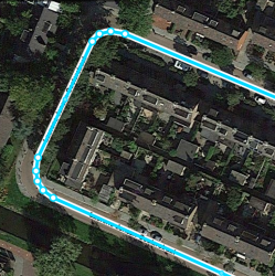
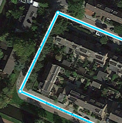
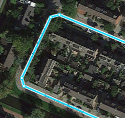
Starting editors often tend to draw the map exactly like the satellite view shows. However, the Waze map should be as simple as possible, in a way that yield the best navigation instructions, with a clear and simple map on screen. This implies that sometimes roads or parts of roads are even not drawn, or drawn differently from the satellite view. As the examples show, when you draw the roads exactly like the actual situation (picture left) you will end up with lots of segments and junctions. This will result in a lot of maintenance, cluttered screen and database load. In addition, the driver receives many unnecessary navigation instructions that can be confusing. Simplified mapping (picture right) yields only one navigation instruction, with an easy and quickly readable map on a small screen.
More examples of drawing complex situations can be found on the KISS page.
Road types
Starting editors often tend to change the road type of a segment. Choosing the type of a road segment has many implications, due to the consequences for visibility, routing and such. These typics can vary across countries and you will see some of these differences when choosing another language in WME. Thus, some road types are differently used than expected at first sight, and some are even not used. If you think a road type should be changed, please consult the last editor or Area Manager. If no response, the Community Management will be happy to help as well.
For more information check the Road types page.
Freeway / Highway
Freeway and Highway are both translated to a single word in Dutch (snelweg) and French (l'autoroute). In Waze however, these road types are distinguished based on the amount of traffic they bear compared to other roads in the neighbourhood, the distance they serve in routing, and the passage possibilities. Therefore, a small local road can be defined a minor highway, and a normal street in a city that serves ongoing traffic as a major highway. This way of dealing with Road types is called Functional Classification (FC). Most of the roads that serve ongoing traffic, will be locked. Changes to these segments can only be made by experienced editors with a rank similar or higher than the lock level. If you think a change to a locked segment is needed, ask an editor with the appropriate rank in [Slack]], or place your request in the map modification forum for Belgium, or Luxembourg).
Pedestrian boardwalks and cycle paths
As Waze is aimed at motorvehicles, both Pedestrian boardwalks and cycle paths are generally not added to the Waze map. However, sometimes we do add them in function of routing. Typically, Pedestrian boardwalks are used for non-drivable roads without destinations, needed to connect to a parking place or public transport entrance. Walking trails are used for roads that are used to bring you to your destination on foot. Both should be connected to the road network. More info on the page about non-drivable roads.
Parking Lots


Parking lot roads should be drawn as simple as possible with the aim at good navigation instructions. There is no added value to draw every lane on a parking lot. With the inaccuracy of GPS, Waze probably does not know on which lane you are exactly, resulting in wrong instructions. Roads on parking lots have no name, except when the road has a housenumber or an official address that can not be linked to a regular street. For further information see the Parking Lot Road page.
Update request (UR)


While driving, a driver can report a problem by submitting an Update Request (UR). Often there is not enough time to fully describe the issue. Therefore, Waze developed the possibility to start a conversation in the UR. Whenever you respond to an UR, you should take this seriously. The user does not report if he or she doesn't encounter a problem! It is your task to solve the problem as best as you can, or find the help needed to solve it. By solving the user's problem, we can improve Waze to serve the needs of all Wazers. Never just close a UR, even if you think it is bogus. Some general guidelines:

- Start with thanking the reporter for reporting the issue.
- If the report is clear and you can solve this issue directly, please do and explain to the reporter what you have done. The reporter receives a message of your comment, and will feel valued for his/her addition. In addition, other editors can learn from your solution and it can help solving other issues in the neighborhood. You can close the UR as "Solved".
- When the issue is not clear, ask the reporter politely for more information.
- If the reporter doesn´t respond to your question within 5 days, you may send a reminder message. It often happens reporters do respond only after a reminder.
- When the reporter also does not respond to your reminder, within 8 days, you can close the UR as "Not identified", with a comment in the conversation why you closed it.
Officially, nobody ´owns´ a UR. However, if another editor is already handling the problem, best not to close it or take over without prior consultation.
More information about UR's see our Update request page. Elaborate information on URs can be read on the global Wiki page Update Requests (global. Be aware, that some global guidelines may differ from ours.
Mass edits
We all are eager to drive with a good map! Therefore, make sure you make quality edits. Massive changes are often difficult to control. In Belux, where the map is very well developed, you might easily overrule some edits that might be done differently than expected on purpose.
- When planning to make structural changes to segments and places: consult with the editors active in the target area. This can be at city/province/regional or national level - depending on the change.
- If there is a massive divergence between the map and the rules, the first action is to communicate about that divergence and then agree upon a coordinated mass-edit. This also applies to recently modified rules!
Tools and scripts are available making editing easy, but also quickly lead to mass editing. Please make sure that you understand the working of the additional tools before using them. Note that Waze throttles you for mass editing, meaning that editing slows down, you're not earning points, up to blocking off the access to WME.
Starting editors: what they can do and what not
Everywhere you have driven using Waze you can edit. In the BeLux the maps are quite good. Although at first you might think there is not much to do for you, please zoom in and you can almost always find something to improve. Even in areas with a lot of editors you will find missing house numbers, charging stations or missing parking lot roads or a part of a street is missing. Also sometimes streetnames are missing or misspelled. Other work you can do is remove unnecessary geometry nodes, see the paragraph Too many geometry nodes. For more ideas check out the Starters Summary. Read the Wiki and just start editing, that way you will learn to use the editor and earn points to get to a higher level.
Because the maps in the BeLux are already quite good, there is also a risk with editing. You can break things that are working fine. Please be aware that some things might look incorrect or not logical to you, but can be correct based on the Basic principles of Waze. Be careful with changing and deleting work of other editors. In case of the slighest doubt, first contact the previous editor.
To make this more clear we have made two lists, one with risky things you better avoid as a starting editor, and another one with things that might get you starting off easy.
Risky activities for starting editors
Unless you work together with a more experienced editor, please be very cautious with the following activities:
- Don't delete road-segments. This also deletes the historic traffic information, e.g. the historic average speed.
- Do not change or delete segments that are connected to locked segments.
- Do not split roads, even when there lanes are physically split.
- Do not change the road type, this has a big influence on the navigation.
- Be careful adding roads like private roads and driveways. They can result in a wrong navigation advice. It will also clutter the map and increase the amount of bandwidth used.
- Do not add parking lots roads when there are already roads on the parking lot mapped.
- Do not close update requests or make changes based to them. If you want to help, because you have local knowledge, please make a comment that can help a more experienced editor, or contact the editor handling it.
- Better not add restrictions based on not (yet) implemented vehicle types.
- Don't make mass changes just because the wiki indicates it. Realize that there might be a reason that something is done in a way that deviates from the wiki guidelines. Best is to contact the last editor, or discuss the issue in Slack.
Things a starting Waze-editor can do
- Read the Quick start guide and then look at the Starters Summary.
- Check if streetnames are filled in and spelled correctly. Use available sources to check.
- Check if the city is filled in correctly.
- Check the driving direction of streets. You can base this on streetview from within Waze, your own local knowledge or other allowed sources. When the source is older than the last edit on the segment, assume that Waze is more up-to-date than your other source and don't change it.
- Check if Junction Arrows are set correctly. With Shift-Z you will see all the red arrows. When you suspect a red junction arrow to be incorrect, first do Shift-Z again and select the segment connected to the junction. That way you can see which segment has the red junction arrow.
- Check the category, name and address of places. The name should be the official name of the place. If you know this place is locally called a different name, please add that name as an alternative. It will improve the search. Also check if this place is visible on the live map, if not, please convert it to a point place, when applicable.
- Inform your area or region manager of possible issues. See the section Communication how to do that.
- Monitor road-closures in your neighboorhood, see our Closures page on how to report them.