mNo edit summary |
|||
| (63 intermediate revisions by 6 users not shown) | |||
| Line 2: | Line 2: | ||
<languages /><translate> | <languages /><translate> | ||
<!--T:1--> | |||
This page provides the basics to start editing the Waze Map. Because Waze is a navigation tool and not a topographic map, some things are drawn differently than expected. Our advice is, after reading this page, to choose one type of edit and first familiarize yourself with all aspects of that edit. Otherwise, you might as well get overfed with information. Your [[community]] is happy to help you make your edits work. | {{hiddenh2|Welcome editor!}} | ||
==How to get to the Waze Map Editor (WME)== | This page provides the basics to start editing the Waze Map. Because Waze is a navigation tool and not a topographic map, some things are drawn differently than expected. Our advice is, after reading this page, to choose one type of edit and first familiarize yourself with all aspects of that edit. Otherwise, you might as well get overfed with information. Don't forget to join [[Slack]], our primary communication platform. Your [[community]] is happy to help you make your edits work. | ||
<!--T:52--> | |||
__TOC__ | |||
=={{@|How to get to the Waze Map Editor (WME)}}== <!--T:2--> | |||
# Log in to www.waze.com. If prompted to login, use the same username and password as you do on the Waze client app and the rest of the Waze website. | # Log in to www.waze.com. If prompted to login, use the same username and password as you do on the Waze client app and the rest of the Waze website. | ||
# Search for your location | # Search for your location | ||
| Line 12: | Line 17: | ||
After logging in, you will see the following page: | After logging in, you will see the following page: | ||
[[File: | <!--T:22--> | ||
[[File:WME_whole_window_2019.PNG|720px]] | |||
{{clear}}{{BackToc{{#translation:}}}} | |||
<!--T:3--> | |||
If you want to learn more about the controls and functions of [[Waze Map Editor|WME]], you can find more details on the global wiki [https://wazeopedia.waze.com/wiki/Global/Map_Editor_Interface_and_Controls WME Interface and Controls] page. | If you want to learn more about the controls and functions of [[Waze Map Editor|WME]], you can find more details on the global wiki [https://wazeopedia.waze.com/wiki/Global/Map_Editor_Interface_and_Controls WME Interface and Controls] page. | ||
==Start in Practice Mode== | =={{@|Start in Practice Mode}}== <!--T:4--> | ||
[[File:Wme-practise-mode.png| | [[File:Wme-practise-mode.png|right|500px]] | ||
Before editing the map for real, you may first want to practice editing. Go to the [https://www.waze.com/editor/?env=row WME server] and choose Practice Mode. If you are already logged into [[Waze Map Editor|WME]], log out first to be able to enter Practice Mode. | Before editing the map for real, you may first want to practice editing. Go to the [https://www.waze.com/editor/?env=row WME server] and choose Practice Mode. If you are already logged into [[Waze Map Editor|WME]], log out first to be able to enter Practice Mode. | ||
The [[Waze Map Editor]] has a Practice mode in which you can perform nearly every action available when logged into the Editor, except that you cannot save any changes. In order to save changes, you must log in. Practice mode is helpful to new and existing editors and should be used to try out new or complicated edits before executing them. | The [[Waze Map Editor]] has a Practice mode in which you can perform nearly every action available when logged into the Editor, except that you cannot save any changes. In order to save changes, you must log in. Practice mode is helpful to new and existing editors and should be used to try out new or complicated edits before executing them. | ||
More information can be found on the global [https://wazeopedia.waze.com/wiki/Global/Waze_Map_Editor#Practice_Mode Practice Mode] page. | More information can be found on the global [https://wazeopedia.waze.com/wiki/Global/Waze_Map_Editor#Practice_Mode Practice Mode] page. | ||
{{clear}}{{BackToc{{#translation:}}}} | |||
==Editing the map== | =={{@|Editing the map}}== <!--T:5--> | ||
Most starting editors at first try to match the map of Waze perfectly to the satellite image. They split roads, add bicycle paths and walking trails, make the roads very fluently and draw detailed places. However, Waze is ''NOT'' a topografical map, but a navigation system that routes you to your destination in the best/fastest way. Therefore, keep the Waze map simple: The lesser the detail, the clearer the map, lesser data use, faster calculations, and easier maintainance. With that in mind, let's start editing the map! | Most starting editors at first try to match the map of Waze perfectly to the satellite image. They split roads, add bicycle paths and walking trails, make the roads very fluently and draw detailed places. However, Waze is ''NOT'' a topografical map, but a navigation system that routes you to your destination in the best/fastest way. Therefore, keep the Waze map simple: The lesser the detail, the clearer the map, lesser data use, faster calculations, and easier maintainance. With that in mind, let's start editing the map! | ||
===Create a Road=== | |||
# Hover the mouse over the [[File:DrawRoads.jpg | ==={{@|Create a Road}}=== <!--T:51--> | ||
# Hover the mouse over the [[File:DrawRoads.jpg]] button on the toolbar at the top of the page and click "Road" (Shortcut key: {{key press|i}}; Roundabouts are explained [[#Create a roundabout|below]]) | |||
# Click the mouse on the map at the point where you want to start the new road segment. | # Click the mouse on the map at the point where you want to start the new road segment. | ||
# Move the mouse cursor along the path of the road and click the mouse to add a [[#Changing elements on the map|geometry node]] for each point that changes direction along the road. | # Move the mouse cursor along the path of the road and click the mouse to add a [[#Changing elements on the map|geometry node]] for each point that changes direction along the road. | ||
# When finished, double-click (or shift-click) the last point to end the segment. | # When finished, double-click (or shift-click) the last point to end the segment. | ||
# Select the segment again, and fill in the details of the segment in the menu pane on the left. | # Select the segment again, and fill in the details of the segment in the menu pane on the left. | ||
* Each segment that is added must have a Country, City, and Street name | * Each segment that is added must have a Country, City, and Street name. Click on the address in the menu left. If there is no City and/or Street name available, then the "None" box(es) must be selected. As long as no City or Street name is specified (or set to "None"), you will see in the editor a red outline around the segment. | ||
* Be sure the road actually exists before creating it. | * Be sure the road actually exists before creating it. | ||
{{BackToc{{#translation:}}}} | |||
<!--T:53--> | |||
===Create a Place=== | [[File:Places categories.png|alt=Places categories|thumb|right|220px|Places categories]]<br /> | ||
Hover over this [[File:DrawPlace.jpg| | |||
< | ==={{@|Create a Place}}=== <!--T:6--> | ||
More information about Places | |||
<!--T:54--> | |||
* Hover over this [[File:DrawPlace.jpg|25 px]] button on the top bar to show [[Place categories]] | |||
* Choose one and click on the map to add it. This will add a point place | |||
* Use the [https://wazeopedia.waze.com/wiki/Global/Map_Editor_Interface_and_Controls#Left_Pane_when_a_Place_is_selected left pane] to change it to an area and to change other information about the place. You can also select sub categories | |||
* To directly insert an area place, click the [[File:Places create area.png]] behind the category | |||
* For an area place, use [[#Geometry nodes|geometry nodes]] of the place to change its shape. | |||
<!--T:55--> | |||
More information about Places in BeLux: [[Places]]. | |||
{{clear}}{{BackToc{{#translation:}}}} | |||
==={{@|Changing elements on the map}}=== <!--T:7--> | |||
To change existing roads or Places, select the object you want to change. Now you can change the shape or appearance by adjusting the road geometry. | |||
<!--T:76--> | |||
'''Geometry nodes''' | '''Geometry nodes''' | ||
[[File:Segments Nodes Junctions.png| | [[File:Segments Nodes Junctions.png|600px]] | ||
< | {{clear}} | ||
[[File:Segment geometry node.png|left]] | |||
[[File:Landmark node.png|left]] | <!--T:77--> | ||
When editing a segment or Area Place, large white circles appear where the segment changes direction ultimately altering its shape. Click and drag them individually to alter the geometry of the segment or Place. Press the | [[File:Segment geometry node.png|left]] | ||
[[File:Landmark node.png|left]] | |||
:When editing a segment or Area Place, large white circles appear where the segment changes direction ultimately altering its shape. Click and drag them individually to alter the geometry of the segment or Place. Press the {{Key press|d}} while the mouse is hovered over them to delete the geometry node. Alternately, hold the {{Key press|d}} and then move the mouse over the [[Nodes|nodes]] you want to delete. | |||
<!--T:78--> | |||
[[File:Segment intergeometry node.png|left]] | [[File:Segment intergeometry node.png|left]] | ||
[[File:Landmark intergeometry node.png|left]] | [[File:Landmark intergeometry node.png|left]] | ||
The smaller white circles between the geometry nodes are "inter"-geometry nodes. When you click and drag an inter-geometry node, it becomes a larger geometry node and two more inter-geometry nodes appear halfway between each side again. | :The smaller white circles between the geometry [[Nodes|nodes]] are "inter"-geometry nodes. When you click and drag an inter-geometry node, it becomes a larger geometry node and two more inter-geometry nodes appear halfway between each side again. | ||
< | |||
* TIP: Under the [[File: | <!--T:79--> | ||
* TIP: Press | * TIP: Under the [[File:Wme-layers-2018.PNG]] Layer icon at the top right in the editing screen, you can turn off the [https://wazeopedia.waze.com/wiki/Global/Map_Editing_Tips_and_Hints#Editing_with_roads_layer_off road layer], to have a better view on the road structure and Satellite Image. | ||
* TIP: Press {{Key press|Delete}} to delete a selected segment, Place, or junction. | |||
{{BackToc{{#translation:}}}} | |||
===Connecting roads=== | ==={{@|Connecting roads}}=== <!--T:8--> | ||
When drawing new segments, or moving segments around, the editor will automatically make junctions. | When drawing new segments, or moving segments around, the editor will automatically make junctions. | ||
# For new roads, if you start and/or end the new segment on an existing segment, a junction is created at the location were you start/end the new segment | # For new roads, if you start and/or end the new segment on an existing segment, a junction is created at the location were you start/end the new segment | ||
# For existing roads, if you move the start or the end of a segment onto an existing segment, a junction is created | # For existing roads, if you move the start or the end of a segment onto an existing segment, a junction is created | ||
# If you move a junction to an existing segment or junction, all roads connected will be part of the junction. | # If you move a junction to an existing segment or junction, all roads connected will be part of the junction. | ||
< | |||
'''Bridging roads''' | <!--T:56--> | ||
'''Bridging roads''' | |||
# Select two adjacent segments which should be joined together | # Select two adjacent segments which should be joined together | ||
# Click the [[File:Bridge | # Click the [[File:Bridge.png]] icon over the junction | ||
* The properties of the segments to be bridged must be identical or you will not see the bridge icon | * The properties of the segments to be bridged must be identical or you will not see the bridge icon | ||
* Bridging automatically increases the level of the new merged segment by 1 more than the highest level of the two segments. You can change it, of course, if it needs to be a different level. | <!--* Bridging automatically increases the level of the new merged segment by 1 more than the highest level of the two segments. You can change it, of course, if it needs to be a different level.[Mo: is not applicable at the moment (doesn't work)--> | ||
Generally, if two segments can be joined, you can also select the junction and press the trash can icon to have them join as well. If the trash can icon does not appear, the segments are different in some way. This might be the reason there is a junction in the first place. For more detail, see the global page on [https://wazeopedia.waze.com/wiki/Global/Overpasses,_Underpasses_and_Bridges Overpasses, Underpasses and Bridges]. | Generally, if two segments can be joined, you can also select the junction and press the trash can icon to have them join as well. If the trash can icon does not appear, the segments are different in some way. This might be the reason there is a junction in the first place. For more detail, see the global page on [https://wazeopedia.waze.com/wiki/Global/Overpasses,_Underpasses_and_Bridges Overpasses, Underpasses and Bridges]. | ||
< | |||
<!--T:57--> | |||
'''Crossing roads'''<br /> | '''Crossing roads'''<br /> | ||
When two roads cross each other at the same elevation level, they can be joined together easily. This is useful if you draw several new roads for a neighborhood by drawing segments from end-to-end and allowing new segments to cross each other. Once drawn, you can junction them using this method. | When two roads cross each other at the same elevation level, they can be joined together easily. This is useful if you draw several new roads for a neighborhood by drawing segments from end-to-end and allowing new segments to cross each other. Once drawn, you can junction them using this method. | ||
# Select both segments by clicking the segments while pressing the <kbd class="keyboard-key nowrap" style="border: 1px solid #aaa; border-radius: 0.2em; box-shadow: 0.1em 0.2em 0.2em #ddd; background-color: #F9F9F9; background-image: linear-gradient(to bottom, #eee, #F9F9F9, #eee); padding: 0.1em 0.3em; font-family: inherit; font-size: 0.85em;">Ctrl</kbd> key | |||
# Click the [[File: | # Click the [[File:Crossing Roads.png]] which should appear above the intersection | ||
# A junction is added | # A junction is added | ||
The sign won't appear if the roads cross each other multiple times, or when elevation levels differ. You can often use this method with unconfirmed (red) roads, but sometimes the editor will refuse to do this process until the roads are confirmed. Additionally, changing zoom level sometimes helps to get the sometimes-stubborn junction creator icon to appear. | The sign won't appear if the roads cross each other multiple times, or when elevation levels differ<!--[Mo: for advance guide: you can however use the delete button-the new roa will automatically get the highest elevation level]-->. You can often use this method with unconfirmed (red) roads, but sometimes the editor will refuse to do this process until the roads are confirmed. Additionally, changing zoom level sometimes helps to get the sometimes-stubborn junction creator icon to appear. Be sure to check the <i>[[Quick start guide#Junction Arrows|Junction Arrows]]</i> for your newly created junctions. | ||
Be sure to check the <i>Junction Arrows</i> for your newly created junctions. | |||
===Junction Arrows=== | <!--T:58--> | ||
For further information see the global page on [https://wazeopedia.waze.com/wiki/Global/Map_Editing_Quick-start_Guide#Overlapping_road_junction Overlapping road junctions]. | |||
{{BackToc{{#translation:}}}} | |||
==={{@|Junction Arrows}}=== <!--T:9--> | |||
[[File:Lotsa turns.jpg|right]] | [[File:Lotsa turns.jpg|right]] | ||
When you select a segment, you can set the turns by clicking the arrows at the junction(s) with other segments. | When you select a segment, you can set the turns by clicking the arrows at the junction(s) with other segments. | ||
< | |||
<!--T:59--> | |||
In General: | In General: | ||
* A green arrow means Allowed | * A green arrow means Allowed | ||
* A yellow arrow with a clock means it is [https://wazeopedia.waze.com/wiki/Global/Partial_restrictions Partially Restricted] (time or vehicle-type based) | * A yellow arrow with a clock means it is [https://wazeopedia.waze.com/wiki/Global/Partial_restrictions Partially Restricted] (time, toll, or vehicle-type based) | ||
* A red arrow with the circle-slash icon means Restricted | * A red arrow with the circle-slash icon means Restricted | ||
Clicking an arrow toggles between Allowed and Restricted (or, between Partially and Fully Restricted). | Clicking an arrow toggles between Allowed and Restricted (or, between Partially and Fully Restricted). | ||
< | |||
<i>NOTE: The slashed-circle icon for Restricted and clock icon for Partial turn restrictions are put in place to allow editors with various forms of color blindness differentiate between the three different types of turn arrows. </i>< | <!--T:83--> | ||
<i>NOTE: The slashed-circle icon for Restricted and clock icon for Partial turn restrictions are put in place to allow editors with various forms of color blindness differentiate between the three different types of turn arrows. </i> | |||
<!--T:10--> | |||
Each arrow must be set correctly for Waze to route correctly. Initial turn restrictions on roads that are imported by Waze, are set automatically by the Waze routing engine. At the moment these are called Soft turns. They are not yet confirmed manually by an editor and you can recognize them at the little question mark next to it. The soft turns can be altered by the routing engine, based on the driving activity. Manually set turns will never be altered by the routing engine. Unfortunately, both automatic and manually restricted turns are represented by red arrows and cannot be distinguished. Currently, when you use the option to enable all turns, it will not fully change the routing from automatic to manual setting, leaving possible so called RevCons. To clear these, select the junction with the mouse. Then, in the left menu pane, click the link to "Disallow all turns" and then "Allow all turns". Alternately you can use the keyboard shortcuts, by pressing the letter {{key press|q}} to disallow all connections, followed by {{key press|w}} to allow all connections. | |||
<!--T:80--> | |||
Keyboard Shortcuts for junction arrowsː | Keyboard Shortcuts for junction arrowsː | ||
:Press | :Press {{key press|s}} to separate overlapping arrows. | ||
:Press | :Press {{key press|a}} to make arrows transparent or opaque, so you can see beneath them or click items under them | ||
:Press | :Press {{key press|q}} to disallow all turns | ||
:Press | :Press {{key press|w}} to allow all turns | ||
:Press | :Press {{key press|Shift|z}} to toggle between seeing the turns for one segement, or seeing all restricted turns (red arrows) for all junctions in your screen. Don't forget to toggle back if actually setting the junction arrows on a segment. | ||
An extended list of [https://wazeopedia.waze.com/wiki/Global/Keyboard_shortcuts Shortcut keys] is on the global page. | |||
{{BackToc{{#translation:}}}} | |||
===Create a roundabout=== | ==={{@|Create a roundabout}}=== <!--T:11--> | ||
[[File:Bord D5.png|left|70px]] Roundabouts in WME yield specific routing instructions to drivers, such as "at the roundabout, take the third exit", or in some cases "at the roundabout, turn left". If those routing instructions could confuse drivers, the Roundabout tool should not be used. A roundabout is added from the top bar menu ''Road'', see extended instructions on the [[Roundabout]] page. | |||
{{BackToc{{#translation:}}}} | |||
==={{@|Create a loop road}}=== <!--T:12--> | |||
<gallery> | |||
Roundabouts in | File:Loop road wrong.png|alt=One segment loop road|thumb|<span style="color:#FF0000">One-segment loop</span> | ||
< | File:Loop road correct.png|alt=three segment loop|thumb|<span style="color:#008000">three segment loop</span> | ||
File:Loop-road-example.png|thumb|<span style="color:#008000">alternate layout</span> | |||
< | </gallery> | ||
Every loop must be made up of three or more segments. Any loop that does not follow this rule can cause problems for the Waze routing server. To avoid problems, make sure there is always only 1 segment between the same 2 junction nodes. Therefore, a loop road always needs 2 extra junction nodes (or side-streets). | |||
<!--T:62--> | |||
If you have to correct a loop road with less than three segments, cut one of the looping segments somewhere, following the instructions in [[#Cutting a segment|Cutting a segment]] and check the [[#Junction Arrows|Junction Arrows]]. | |||
<!--T:63--> | |||
Please note, a real loop road should only be sparsely used with care. For more information, see the article Loops in the global Wiki page [https://wazeopedia.waze.com/wiki/Global/Junction_Style_Guide Junction Style Guide]. | Please note, a real loop road should only be sparsely used with care. For more information, see the article Loops in the global Wiki page [https://wazeopedia.waze.com/wiki/Global/Junction_Style_Guide Junction Style Guide]. | ||
{{BackToc{{#translation:}}}} | |||
=== | ==={{@|cul-de-sac}}=== | ||
[[File:Jct cul-de-sac island ex.png|thumb]] | |||
This cul-de-sac, with a small island, should be treated as a basic dead end with no loop. The island can be ignored, as there is no significant routing question for the driver once they get to the cul-de-sac. | |||
{{BackToc{{#translation:}}}} | |||
{{clear}} | |||
===Walking Trails / Pedestrian Boardwalks=== | ==={{@|Cutting a segment}}=== <!--T:13--> | ||
You can cut a segment into two new segments. You can do this by adding a new segment from some random point nearby, to the | |||
# [[#Create_a_Road|Add a new road]]. Start at a random spot nearby, and double click at the point of the segment where you want to cut it | |||
# A new junction will be added. | |||
# Delete the new segment just created. | |||
# The newly created junction will remain and you made two new segments out of one. | |||
# If you need to actually separate the road segments at that point, just relocate the end point of one of the two new segments. | |||
<!--T:82--> | |||
Concerning a road with multiple lanes, please read this [[Improve_your_skills#Splitting_multiple_lanes|paragraph about splitting or not]]. | |||
==={{@|Walking Trails / Pedestrian Boardwalks}}=== <!--T:14--> | |||
Adding [[Walking trail|Walking Trails]] or [[Pedestrian Boardwalk|Pedestrian Boardwalks]] should only be done exceptionally. Do not add any before reading the general [[Non-drivable roads]] information and detailed information and guidelines on [[Pedestrian Boardwalk|Pedestrian Boardwalks]] and [[Walking trail|Walking Trails]]. When you have any doubt just ask your [[Community]]. | Adding [[Walking trail|Walking Trails]] or [[Pedestrian Boardwalk|Pedestrian Boardwalks]] should only be done exceptionally. Do not add any before reading the general [[Non-drivable roads]] information and detailed information and guidelines on [[Pedestrian Boardwalk|Pedestrian Boardwalks]] and [[Walking trail|Walking Trails]]. When you have any doubt just ask your [[Community]]. | ||
===Parking lots=== | ==={{@|Parking lots}}=== <!--T:15--> | ||
[[File: | [[File:WME_ParkingLot_corrects.PNG|right|200px]] | ||
[[File: | [[File:WNE_ParkingLotPlace.PNG|right|200px]] | ||
Parking Lots are sparsely drawn, to prevent cluttering the map. The most important thing is that people can be routed to and from a parking lot. For small Parking Lots, a single road segment often suffices. For large Parking Lots (for example at an event center) consider mapping only the following: | Parking Lots are sparsely drawn, to prevent cluttering the map. The most important thing is that people can be routed to and from a parking lot. For small Parking Lots, a single road segment often suffices. For large Parking Lots (for example at an event center) consider mapping only the following: | ||
* Main entrances from the roads outside the parking lot | * Main entrances from the roads outside the parking lot | ||
| Line 137: | Line 183: | ||
* Lanes that run along main roads outside the parking area (to separate different speed tracks) | * Lanes that run along main roads outside the parking area (to separate different speed tracks) | ||
* Large parking lot lanes that serve to get people from one area of the lot to another | * Large parking lot lanes that serve to get people from one area of the lot to another | ||
Parking Lot Roads need to be defined as such in the menu pane left. They generate a large penalty to prevent thru-traffic in the navigation. | Parking Lot Roads need to be defined as such in the menu pane left. They generate a large penalty to prevent thru-traffic in the navigation. | ||
< | |||
A Parking Lot Road only gets the City defined, without a street name (check the "None" box), unless it's an official street. Never use generic names, like 'Parking Theater'. For detailed information, please read the page about [[Parking Lot Road|Parking Lot Roads]] in | <!--T:64--> | ||
< | A Parking Lot Road only gets the City defined, without a street name (check the "None" box), unless it's an official street. Never use generic names, like 'Parking Theater'. For detailed information, please read the page about [[Parking Lot Road|Parking Lot Roads]] in BeLux. | ||
For large Parking Lots that are distinctive and significant, and for general purpose and public use, a [[Parking Lot Place]] can be drawn. | |||
===Housenumbers=== | <!--T:65--> | ||
For large Parking Lots that are distinctive and significant, and for general purpose and public use, a [[Parking Lot Place]] can be drawn. | |||
< | {{BackToc{{#translation:}}}} | ||
{{clear}} | |||
==={{@|Housenumbers}}=== <!--T:24--> | |||
House numbers can be added to segments with a [[Street and City names|Street name]]. This comes handy especially when a search result from another source lead to the wrong location. Besides regular numbers like 123, Waze can handle the format 123A and 123-1. More info on the extended page on [[House numbers]]. | |||
{{BackToc{{#translation:}}}} | |||
=={{@|Solve Map Problems (MPs) and User Requests (URs)}}== <!--T:16--> | |||
Solving [[File:Problem pin open-low.png]] MPs and [[File:Request pin open-low.png]] URs needs attention and often quite some knowledge. Unless you are sure about the problem (e.g., you are local and checked the situation), it is not advised to do this when you are a starter to WME. More information can be read on the pages about [[Update request]] and [[Map Problems]]. | |||
=={{@|Closing a street}}== <!--T:17--> | |||
If you've knowledge of planned roadworks or you come across a a closed street, the best thing to do is request a [[Closures|closure]]. As a starting editor you're not yet able to set [[Closures|closures]] yourself. Requesting a closure can be done via the [[Slack]] closure channel. A closure is instantly active and is used for temporary blockades. | |||
<!--T:67--> | |||
Another way to prevent routing going through a street is by adding a [[Restrictions|restriction]]. Restrictions are used for blocking a street on specific days, times or blocking specific vehicle types. [[Restrictions]] are not meant for temporary situations, like roadworks or accidents. They are really part of the map. Restriction changes need a map update, so they will take probably one or two days to become active. | |||
{{BackToc{{#translation:}}}} | |||
=={{@|How to make a permalink}}== <!--T:18--> | |||
Goto the [[PL|Permalink]] page. | |||
<!--T:74--> | |||
{{BackToc{{#translation:}}}} | |||
== | =={{@|Use of external resources}}== <!--T:19--> | ||
You, yourself have invaluable knowledge of your surroundings: this is the best free, up to date and reliable source to be used in editing the map. | |||
<!--T:81--> | |||
Besides your own eyes you can use: | |||
* the <i>internal Streetview</i> that is available from the [[Waze Map Editor|WME]]. Drag the street view icon [[File:Lens-Icon.PNG|35px]] from above the zoom control bottom right to the point where you want to see the street view. Beware that the situation can be changed. | |||
Besides your own eyes you can use | * the <i>Satellite imagery</i>, to be enabled / disabled via the [[File:Wme-layers-2018.PNG]] layers menu. Waze uses aerial and satellite photography provided by Google. | ||
* the <i>internal Streetview</i> that is available from the [[Waze Map Editor|WME]]. Drag the | |||
* the <i>Satellite imagery</i>, to be | |||
<!--T:20--> | |||
Be very careful using other, external sources for editing the map; some policies or conditions restrict the use or duplication of the data and could lead to a complete deletion of the country map. Read more on the [[Resources]] page. | |||
{{BackToc{{#translation:}}}} | |||
==Take the next step== | =={{@|Take the next step}}== <!--T:21--> | ||
* The sequel to this <i>Quick-Start Guide</i> can be found in in the [[ | * The sequel to this <i>Quick-Start Guide</i> can be found in in the [[Advanced Guide]] | ||
* Helpfull tips and often encountered problems when starting editing are described in [[Improve your skills]]. | * Helpfull tips and often encountered problems when starting editing are described in [[Improve your skills]]. | ||
* Don't forget to join your [[Community|fellow Wazers]], who will be happy to meet you!<br /> | * Don't forget to join your [[Community|fellow Wazers]], who will be happy to meet you!<br /> | ||
<br /> | <br /> | ||
<!--T:25--> | |||
[[File:WazeMapEditing.png]] | [[File:WazeMapEditing.png]] | ||
</translate> | |||
</translate> | |||
{{Bottomline}} | {{Bottomline}} | ||
[[Category:Editing{{#translation:}}]] | |||
[[Category:Tools{{#translation:}}]] | |||
[[Category:Tutorials{{#translation:}}]] | |||
Latest revision as of 06:25, 8 September 2021

This page provides the basics to start editing the Waze Map. Because Waze is a navigation tool and not a topographic map, some things are drawn differently than expected. Our advice is, after reading this page, to choose one type of edit and first familiarize yourself with all aspects of that edit. Otherwise, you might as well get overfed with information. Don't forget to join Slack, our primary communication platform. Your community is happy to help you make your edits work.
How to get to the Waze Map Editor (WME) 
- Log in to www.waze.com. If prompted to login, use the same username and password as you do on the Waze client app and the rest of the Waze website.
- Search for your location
- Click live map
- Click edit the map
Or, go directly to www.waze.com/editor/?env=row.
After logging in, you will see the following page:

If you want to learn more about the controls and functions of WME, you can find more details on the global wiki WME Interface and Controls page.
Start in Practice Mode

Before editing the map for real, you may first want to practice editing. Go to the WME server and choose Practice Mode. If you are already logged into WME, log out first to be able to enter Practice Mode. The Waze Map Editor has a Practice mode in which you can perform nearly every action available when logged into the Editor, except that you cannot save any changes. In order to save changes, you must log in. Practice mode is helpful to new and existing editors and should be used to try out new or complicated edits before executing them. More information can be found on the global Practice Mode page.
Editing the map
Most starting editors at first try to match the map of Waze perfectly to the satellite image. They split roads, add bicycle paths and walking trails, make the roads very fluently and draw detailed places. However, Waze is NOT a topografical map, but a navigation system that routes you to your destination in the best/fastest way. Therefore, keep the Waze map simple: The lesser the detail, the clearer the map, lesser data use, faster calculations, and easier maintainance. With that in mind, let's start editing the map!
Create a Road
- Hover the mouse over the
 button on the toolbar at the top of the page and click "Road" (Shortcut key: i; Roundabouts are explained below)
 - Click the mouse on the map at the point where you want to start the new road segment.
- Move the mouse cursor along the path of the road and click the mouse to add a geometry node for each point that changes direction along the road.
- When finished, double-click (or shift-click) the last point to end the segment.
- Select the segment again, and fill in the details of the segment in the menu pane on the left.
- Each segment that is added must have a Country, City, and Street name. Click on the address in the menu left. If there is no City and/or Street name available, then the "None" box(es) must be selected. As long as no City or Street name is specified (or set to "None"), you will see in the editor a red outline around the segment.
- Be sure the road actually exists before creating it.

Create a Place
- Hover over this
 button on the top bar to show Place categories
 - Choose one and click on the map to add it. This will add a point place
- Use the left pane to change it to an area and to change other information about the place. You can also select sub categories
- To directly insert an area place, click the
 behind the category
 - For an area place, use geometry nodes of the place to change its shape.
More information about Places in BeLux: Places.
Changing elements on the map
To change existing roads or Places, select the object you want to change. Now you can change the shape or appearance by adjusting the road geometry.
Geometry nodes


- When editing a segment or Area Place, large white circles appear where the segment changes direction ultimately altering its shape. Click and drag them individually to alter the geometry of the segment or Place. Press the d while the mouse is hovered over them to delete the geometry node. Alternately, hold the d and then move the mouse over the nodes you want to delete.


- The smaller white circles between the geometry nodes are "inter"-geometry nodes. When you click and drag an inter-geometry node, it becomes a larger geometry node and two more inter-geometry nodes appear halfway between each side again.
- TIP: Under the
 Layer icon at the top right in the editing screen, you can turn off the road layer, to have a better view on the road structure and Satellite Image.
 - TIP: Press Delete to delete a selected segment, Place, or junction.
Connecting roads
When drawing new segments, or moving segments around, the editor will automatically make junctions.
- For new roads, if you start and/or end the new segment on an existing segment, a junction is created at the location were you start/end the new segment
- For existing roads, if you move the start or the end of a segment onto an existing segment, a junction is created
- If you move a junction to an existing segment or junction, all roads connected will be part of the junction.
Bridging roads
- Select two adjacent segments which should be joined together
- Click the
 icon over the junction

- The properties of the segments to be bridged must be identical or you will not see the bridge icon
Generally, if two segments can be joined, you can also select the junction and press the trash can icon to have them join as well. If the trash can icon does not appear, the segments are different in some way. This might be the reason there is a junction in the first place. For more detail, see the global page on Overpasses, Underpasses and Bridges.
Crossing roads
When two roads cross each other at the same elevation level, they can be joined together easily. This is useful if you draw several new roads for a neighborhood by drawing segments from end-to-end and allowing new segments to cross each other. Once drawn, you can junction them using this method.
- Select both segments by clicking the segments while pressing the Ctrl key
- Click the
 which should appear above the intersection
 - A junction is added

The sign won't appear if the roads cross each other multiple times, or when elevation levels differ. You can often use this method with unconfirmed (red) roads, but sometimes the editor will refuse to do this process until the roads are confirmed. Additionally, changing zoom level sometimes helps to get the sometimes-stubborn junction creator icon to appear. Be sure to check the Junction Arrows for your newly created junctions.
For further information see the global page on Overlapping road junctions.
Junction Arrows

When you select a segment, you can set the turns by clicking the arrows at the junction(s) with other segments.
In General:
- A green arrow means Allowed
- A yellow arrow with a clock means it is Partially Restricted (time, toll, or vehicle-type based)
- A red arrow with the circle-slash icon means Restricted
Clicking an arrow toggles between Allowed and Restricted (or, between Partially and Fully Restricted).
NOTE: The slashed-circle icon for Restricted and clock icon for Partial turn restrictions are put in place to allow editors with various forms of color blindness differentiate between the three different types of turn arrows.
Each arrow must be set correctly for Waze to route correctly. Initial turn restrictions on roads that are imported by Waze, are set automatically by the Waze routing engine. At the moment these are called Soft turns. They are not yet confirmed manually by an editor and you can recognize them at the little question mark next to it. The soft turns can be altered by the routing engine, based on the driving activity. Manually set turns will never be altered by the routing engine. Unfortunately, both automatic and manually restricted turns are represented by red arrows and cannot be distinguished. Currently, when you use the option to enable all turns, it will not fully change the routing from automatic to manual setting, leaving possible so called RevCons. To clear these, select the junction with the mouse. Then, in the left menu pane, click the link to "Disallow all turns" and then "Allow all turns". Alternately you can use the keyboard shortcuts, by pressing the letter q to disallow all connections, followed by w to allow all connections.
Keyboard Shortcuts for junction arrowsː
- Press s to separate overlapping arrows.
- Press a to make arrows transparent or opaque, so you can see beneath them or click items under them
- Press q to disallow all turns
- Press w to allow all turns
- Press ⇧ Shift+z to toggle between seeing the turns for one segement, or seeing all restricted turns (red arrows) for all junctions in your screen. Don't forget to toggle back if actually setting the junction arrows on a segment.
An extended list of Shortcut keys is on the global page.
Create a roundabout

Roundabouts in WME yield specific routing instructions to drivers, such as "at the roundabout, take the third exit", or in some cases "at the roundabout, turn left". If those routing instructions could confuse drivers, the Roundabout tool should not be used. A roundabout is added from the top bar menu Road, see extended instructions on the Roundabout page.
Create a loop road
-

One-segment loop
-

three segment loop
-
alternate layout


Every loop must be made up of three or more segments. Any loop that does not follow this rule can cause problems for the Waze routing server. To avoid problems, make sure there is always only 1 segment between the same 2 junction nodes. Therefore, a loop road always needs 2 extra junction nodes (or side-streets).
If you have to correct a loop road with less than three segments, cut one of the looping segments somewhere, following the instructions in Cutting a segment and check the Junction Arrows.
Please note, a real loop road should only be sparsely used with care. For more information, see the article Loops in the global Wiki page Junction Style Guide.
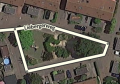
cul-de-sac

This cul-de-sac, with a small island, should be treated as a basic dead end with no loop. The island can be ignored, as there is no significant routing question for the driver once they get to the cul-de-sac.
Cutting a segment
You can cut a segment into two new segments. You can do this by adding a new segment from some random point nearby, to the
- Add a new road. Start at a random spot nearby, and double click at the point of the segment where you want to cut it
- A new junction will be added.
- Delete the new segment just created.
- The newly created junction will remain and you made two new segments out of one.
- If you need to actually separate the road segments at that point, just relocate the end point of one of the two new segments.
Concerning a road with multiple lanes, please read this paragraph about splitting or not.
Walking Trails / Pedestrian Boardwalks
Adding Walking Trails or Pedestrian Boardwalks should only be done exceptionally. Do not add any before reading the general Non-drivable roads information and detailed information and guidelines on Pedestrian Boardwalks and Walking Trails. When you have any doubt just ask your Community.
Parking lots


Parking Lots are sparsely drawn, to prevent cluttering the map. The most important thing is that people can be routed to and from a parking lot. For small Parking Lots, a single road segment often suffices. For large Parking Lots (for example at an event center) consider mapping only the following:
- Main entrances from the roads outside the parking lot
- Lanes that run along entrances of buildings
- Lanes that run along main roads outside the parking area (to separate different speed tracks)
- Large parking lot lanes that serve to get people from one area of the lot to another
Parking Lot Roads need to be defined as such in the menu pane left. They generate a large penalty to prevent thru-traffic in the navigation.
A Parking Lot Road only gets the City defined, without a street name (check the "None" box), unless it's an official street. Never use generic names, like 'Parking Theater'. For detailed information, please read the page about Parking Lot Roads in BeLux.
For large Parking Lots that are distinctive and significant, and for general purpose and public use, a Parking Lot Place can be drawn.
Housenumbers
House numbers can be added to segments with a Street name. This comes handy especially when a search result from another source lead to the wrong location. Besides regular numbers like 123, Waze can handle the format 123A and 123-1. More info on the extended page on House numbers.
Solve Map Problems (MPs) and User Requests (URs)
Solving ![]() MPs and
MPs and ![]() URs needs attention and often quite some knowledge. Unless you are sure about the problem (e.g., you are local and checked the situation), it is not advised to do this when you are a starter to WME. More information can be read on the pages about Update request and Map Problems.
URs needs attention and often quite some knowledge. Unless you are sure about the problem (e.g., you are local and checked the situation), it is not advised to do this when you are a starter to WME. More information can be read on the pages about Update request and Map Problems.
Closing a street
If you've knowledge of planned roadworks or you come across a a closed street, the best thing to do is request a closure. As a starting editor you're not yet able to set closures yourself. Requesting a closure can be done via the Slack closure channel. A closure is instantly active and is used for temporary blockades.
Another way to prevent routing going through a street is by adding a restriction. Restrictions are used for blocking a street on specific days, times or blocking specific vehicle types. Restrictions are not meant for temporary situations, like roadworks or accidents. They are really part of the map. Restriction changes need a map update, so they will take probably one or two days to become active.
How to make a permalink
Goto the Permalink page.
Use of external resources
You, yourself have invaluable knowledge of your surroundings: this is the best free, up to date and reliable source to be used in editing the map.
Besides your own eyes you can use:
- the internal Streetview that is available from the WME. Drag the street view icon
 from above the zoom control bottom right to the point where you want to see the street view. Beware that the situation can be changed.
 - the Satellite imagery, to be enabled / disabled via the layers menu. Waze uses aerial and satellite photography provided by Google.
Be very careful using other, external sources for editing the map; some policies or conditions restrict the use or duplication of the data and could lead to a complete deletion of the country map. Read more on the Resources page.
Take the next step
- The sequel to this Quick-Start Guide can be found in in the Advanced Guide
- Helpfull tips and often encountered problems when starting editing are described in Improve your skills.
- Don't forget to join your fellow Wazers, who will be happy to meet you!
