No higher resolution available.
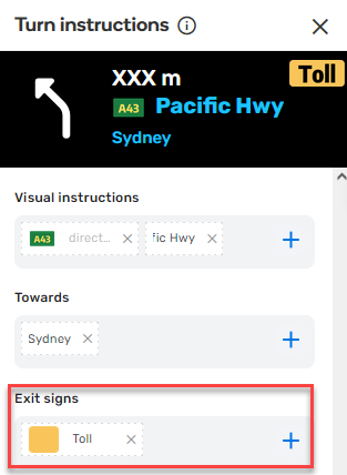
Toll-exit-shield.png (313 × 428 pixels, file size: 26 KB, MIME type: image/png)
Summary
Mapping a toll exit shield.
File history
Click on a date/time to view the file as it appeared at that time.
| Date/Time | Thumbnail | Dimensions | User | Comment | |
|---|---|---|---|---|---|
| current | 09:56, 27 February 2022 | | 313 × 428 (26 KB) | LostInMyMaps (talk | contribs) | Mapping a toll exit shield. |
You cannot overwrite this file.
File usage
There are no pages that use this file.