This special page shows all uploaded files.
| Date | Name | Thumbnail | Size | Description | Versions |
|---|---|---|---|---|---|
| 16:57, 8 January 2018 | Auxiliary segment.jpg (file) |  |
19 KB | 1 | |
| 21:12, 8 January 2018 | Auxiliary left lane segment.jpg (file) |  |
25 KB | 1 | |
| 11:54, 9 January 2018 | White image.jpg (file) |  |
883 bytes | 2 | |
| 12:20, 9 January 2018 | Street and minor highway junction.JPG (file) |  |
7 KB | 4 | |
| 12:29, 9 January 2018 | Junction of different types of streets.JPG (file) |  |
7 KB | 6 | |
| 12:31, 9 January 2018 | Street and divided primary street junction.JPG (file) |  |
7 KB | 3 | |
| 12:32, 9 January 2018 | PLR and divided road junction.JPG (file) |  |
7 KB | 3 | |
| 12:33, 9 January 2018 | Street and ninor highway junction.JPG (file) |  |
7 KB | 3 | |
| 12:34, 9 January 2018 | H junction.jpg (file) |  |
6 KB | 1 | |
| 12:34, 9 January 2018 | Street primary street minor highway junction.jpg (file) |  |
7 KB | 1 | |
| 15:07, 9 January 2018 | At grade connector.jpg (file) |  |
15 KB | 3 | |
| 11:53, 12 February 2018 | Village entrance.jpg (file) |  |
19 KB | Loaded again with different name since there is a bug in updating files. | 10 |
| 11:56, 12 February 2018 | Village entrance editing.jpg (file) |  |
19 KB | There is a bug in updating files. | 1 |
| 12:21, 16 May 2018 | Narrow Street Type.jpg (file) |  |
101 KB | 1 | |
| 19:04, 29 September 2018 | WME Freeway exits.jpg (file) |  |
31 KB | 2 | |
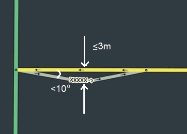
| 11:10, 30 September 2018 | Auxiliary segment to continue straight.jpg (file) |  |
47 KB | 1 | |
| 13:15, 30 September 2018 | Small non ramp segment.jpg (file) |  |
4 KB | 2 | |
| 13:27, 30 September 2018 | Freeway exits.jpg (file) |  |
35 KB | 2 | |
| 10:33, 2 October 2018 | Keep to the left exception.jpg (file) |  |
30 KB | 1 | |
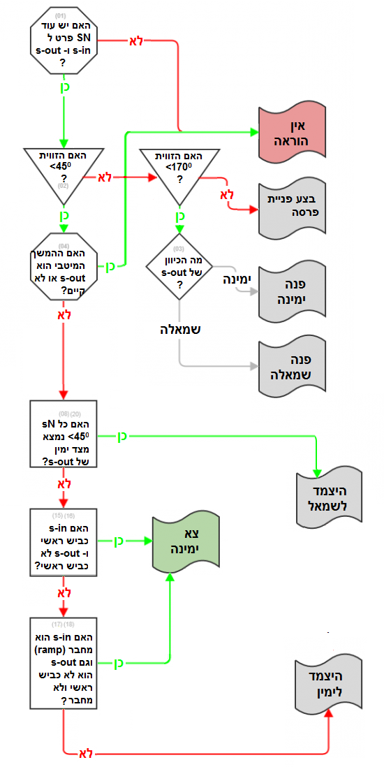
| 11:58, 5 October 2018 | Instructions algorithm flowchart.png (file) |  |
207 KB | 1 | |
| 20:02, 13 January 2019 | Type Narrow Street.png (file) | 292 bytes | New image of this type | 4 | |
| 21:50, 16 January 2019 | Level 2 Editable Area.jpg (file) |  |
94 KB | 2 | |
| 15:50, 7 April 2019 | Add restrictions.PNG (file) |  |
1 KB | 1 | |
| 08:31, 9 April 2019 | Allowed Vehicles.JPG (file) |  |
17 KB | 1 | |
| 08:50, 9 April 2019 | Allowed Vehicles for Toll Segment.JPG (file) | 15 KB | 1 | ||
| 14:08, 9 April 2019 | Add New.JPG (file) |  |
8 KB | 1 | |
| 14:45, 5 October 2019 | Several Partial Restrictions.JPG (file) |  |
22 KB | 1 | |
| 15:00, 7 December 2019 | עורך המפה.JPG (file) |  |
8 KB | 1 | |
| 17:53, 9 December 2019 | Copy Closure Icon.jpg (file) | 1 KB | 1 | ||
| 18:02, 9 December 2019 | Apply closure for all.jpg (file) | 2 KB | 1 | ||
| 14:57, 25 December 2019 | SaveButtonHebrew.png (file) |  |
1 KB | 1 | |
| 15:18, 25 December 2019 | AddRoadHebrew.png (file) |  |
665 bytes | 1 | |
| 16:55, 25 December 2019 | כביש אגרה.jpg (file) | 2 KB | 1 | ||
| 16:57, 25 December 2019 | רחוב לא סלול.jpg (file) | 2 KB | 1 | ||
| 17:17, 25 December 2019 | RoundaboutButtonHebrew.png (file) | 897 bytes | 1 | ||
| 14:06, 26 December 2019 | כביש שנערך ללא כתובת.jpg (file) | 2 KB | 4 | ||
| 15:53, 27 December 2019 | Icons on top of place details.PNG (file) | 2 KB | 1 | ||
| 08:16, 28 December 2019 | More info Parking.PNG (file) |  |
19 KB | 2 | |
| 08:28, 28 December 2019 | HorizontalSpace.PNG (file) | 152 bytes | 1 | ||
| 08:43, 28 December 2019 | WME Zoom Control.PNG (file) |  |
935 bytes | 1 | |
| 08:52, 28 December 2019 | My Location Icon.PNG (file) | 1 KB | 1 | ||
| 09:11, 28 December 2019 | SV cursor no view.png (file) |  |
2 KB | 1 | |
| 09:16, 28 December 2019 | SV cursor with view.png (file) |  |
2 KB | 1 | |
| 09:32, 28 December 2019 | StreetViewIsrael.PNG (file) |  |
3.87 MB | 1 | |
| 10:02, 28 December 2019 | LayersIconHebrew.PNG (file) |  |
1 KB | 1 | |
| 10:53, 28 December 2019 | MapWithoutSat.JPG (file) |  |
267 KB | 2 | |
| 11:08, 28 December 2019 | MapWithSat.JPG (file) |  |
445 KB | 1 | |
| 11:25, 28 December 2019 | AreaManagersLayerIsrael.JPG (file) |  |
377 KB | 1 | |
| 11:32, 28 December 2019 | PlacesLayerIsrael.JPG (file) |  |
468 KB | 1 | |
| 12:45, 28 December 2019 | SpeedCamIsrael.JPG (file) |  |
35 KB | 2 |