This special page shows all uploaded files.
| Date | Name | Thumbnail | Size | Description | Versions |
|---|---|---|---|---|---|
| 06:54, 22 February 2024 | Aus-PH-Not-A-Speed-bump01.png (file) |  |
506 KB | 1 | |
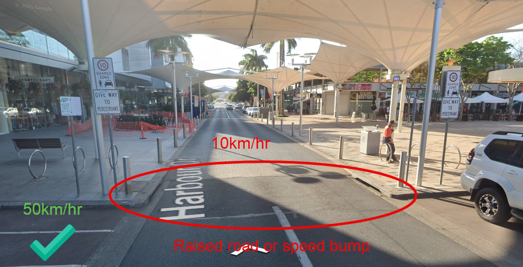
| 06:49, 22 February 2024 | Aus-PH-Speed-bump-before-shared-speed-zone-entry01.png (file) |  |
927 KB | 1 | |
| 06:46, 22 February 2024 | Aus-PH-Rasied-intersection01.png (file) |  |
422 KB | 1 | |
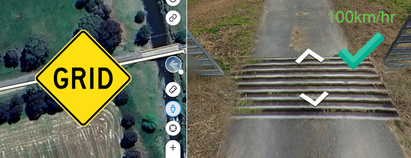
| 06:43, 22 February 2024 | Aus-PH-Grid01.png (file) |  |
478 KB | 1 | |
| 06:42, 22 February 2024 | Aus-PH-Rasied-pedestrian-crossing-40-zone-02.png (file) |  |
414 KB | 1 | |
| 06:41, 22 February 2024 | Aus-PH-Rasied-pedestrian-crossing01.png (file) |  |
391 KB | 1 | |
| 06:39, 22 February 2024 | Aus-PH-Speed-bump01.png (file) |  |
498 KB | 1 | |
| 06:37, 22 February 2024 | Aus-PH-Pdestrian-crossing01.png (file) |  |
640 KB | 1 | |
| 06:19, 22 February 2024 | Aus-PH-Alerter02.png (file) |  |
188 KB | 1 | |
| 06:17, 22 February 2024 | Aus-PH-Alerter01.png (file) |  |
86 KB | 1 | |
| 06:12, 22 February 2024 | AUS-PH-App Notification.jpeg (file) |  |
347 KB | A pop up message from the Waze application educating drivers about permanent hazard notifications. | 1 |
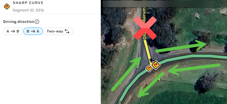
| 05:53, 22 February 2024 | Aus-PH-Sharp curve apex 01.png (file) |  |
225 KB | An example of an intersection at the apex of a sharp curve, where PH should be mapped as one way to avoid alerts to drivers joining from the apex. | 1 |
| 05:52, 22 February 2024 | Aus-PH-Sharp curve04.png (file) |  |
399 KB | An example of red reduce speed sign before a curve, where the mapping of a sharp curve is acceptable. | 1 |
| 05:51, 22 February 2024 | Aus-PH-Sharp curve03.png (file) |  |
645 KB | An example of advisory signage where the speed drops by 50km/hr or more, where the mapping of a sharp curve is acceptable. | 1 |
| 05:51, 22 February 2024 | Aus-PH-Sharp curve02.png (file) |  |
180 KB | An example of advisory signage where the speed drops by 50km/hr or more, where the mapping of a sharp curve is acceptable. | 1 |
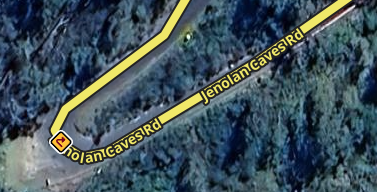
| 05:50, 22 February 2024 | Aus-PH-Sharp curve01.png (file) |  |
160 KB | An example of a hairpin turn/bend seen in Australia where the mapping of a sharp curve is acceptable. | 1 |
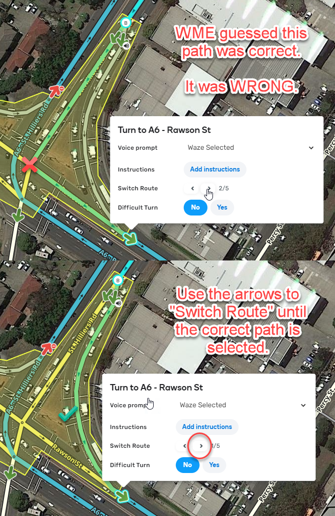
| 11:58, 28 October 2022 | Junction-box-select-correct-path.png (file) |  |
1.09 MB | WME attempts to select the best route, but it is often wrong. The first path is incorrect. Use the Switch Route arrows to the select the correct path, in this case, using the turn lane. | 1 |
| 11:29, 28 October 2022 | Junction-box-entry-path-exits.png (file) |  |
681 KB | A junction box defines paths through it, made up of an entry, a route along multiple segments within it, ending at an exit. | 1 |
| 13:41, 13 July 2022 | SugMod 50.png (file) |  |
3 KB | Waze Beta Suggestion Moderator (SugMod) | 1 |
| 13:41, 13 July 2022 | SugMod 334.png (file) |  |
70 KB | Waze Beta Suggestion Moderator (SugMod) | 1 |
| 13:41, 13 July 2022 | SugMod.png (file) |  |
149 KB | Waze Beta Suggestion Moderator (SugMod) | 1 |
| 13:40, 13 July 2022 | Beta Leader 50.png (file) |  |
5 KB | Waze Beta Leader | 1 |
| 13:39, 13 July 2022 | Beta Leader 334.png (file) |  |
63 KB | Waze Beta Leader | 1 |
| 13:37, 13 July 2022 | Beta Leader.png (file) |  |
100 KB | Waze Beta Leader | 1 |
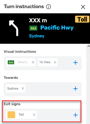
| 09:56, 27 February 2022 | Toll-exit-shield.png (file) |  |
26 KB | Mapping a toll exit shield. | 1 |
| 12:18, 23 October 2021 | Perfect-dogleg-example.png (file) |  |
357 KB | This example is considered to be the "perfect dogleg", as supplied by Gil from Waze. Source: https://www.waze.com/forum/viewtopic.php?t=330505 | 1 |
| 01:25, 26 September 2021 | Complex-intersection-for-junction-box.png (file) |  |
581 KB | An example of a complex intersection that would benefit from a junction box. How long it takes a driver to transition each individual segment inside this complex intersection isn't very useful. It is much more useful for Waze to see this as "one intersection" by adding a junction box, and understand the transitions times for specific routes through it. | 1 |
| 07:36, 10 September 2021 | Waze-toll-icon.png (file) | 38 KB | The Waze toll icon on a transparent background. | 1 | |
| 16:13, 9 September 2021 | 07 Emeritus local champs blue.png (file) |  |
20 KB | 1 | |
| 16:12, 9 September 2021 | 03 Coordinator.png (file) |  |
10 KB | 1 | |
| 16:12, 9 September 2021 | 02 Local Champ Badge.png (file) | 14 KB | 1 | ||
| 16:10, 9 September 2021 | 01 Champ Global Badge small.png (file) | 24 KB | 1 | ||
| 15:47, 9 September 2021 | WazeStaffAdmin Badge.png (file) | 9 KB | 1 | ||
| 15:34, 9 September 2021 | Waze-checklist 150.png (file) |  |
17 KB | 1 | |
| 15:33, 9 September 2021 | Profile badge L1.png (file) | 13 KB | 1 | ||
| 15:32, 9 September 2021 | Dino mood 50.png (file) |  |
3 KB | 1 | |
| 15:32, 9 September 2021 | Pixel mood 50x50.png (file) | 2 KB | 1 | ||
| 15:32, 9 September 2021 | Robot mood 50x50.png (file) |  |
4 KB | 1 | |
| 15:06, 9 September 2021 | Social-media-tile.png (file) |  |
10 KB | 1 | |
| 14:32, 9 September 2021 | Beta-tile.png (file) |  |
14 KB | 1 | |
| 14:32, 9 September 2021 | Carpool-tile.png (file) |  |
25 KB | 1 | |
| 14:32, 9 September 2021 | Partners-tile.png (file) |  |
22 KB | 1 | |
| 14:31, 9 September 2021 | Localizers-title.png (file) |  |
21 KB | 1 | |
| 14:31, 9 September 2021 | Map-editors-tile.png (file) |  |
22 KB | 1 | |
| 14:31, 9 September 2021 | The-waze-community-champs-phenomenal.png (file) | 22 KB | 1 | ||
| 14:30, 9 September 2021 | The-waze-community-editors-intensive.png (file) | 23 KB | 1 | ||
| 14:30, 9 September 2021 | The-waze-community-reporters-active.png (file) | 20 KB | 1 | ||
| 14:30, 9 September 2021 | The-waze-community-drivers-passive.png (file) | 20 KB | 1 | ||
| 01:36, 1 September 2021 | Carpool-pickup-with-footpath.png (file) |  |
11 KB | 1 | |
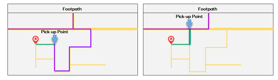
| 01:35, 1 September 2021 | Footpath-Australia.png (file) |  |
24 KB | How footpath segments are routed to | 1 |