Segmentos Bloqueados


¿Por qué hay calles bloqueadas?
Con el único objetivo de prevenir daños potenciales al mapa y evitar desconexiones en las principales vías del país, se ha determinado que las vías principales estén bloqueadas para edición según su nivel de importancia:
Bloqueos
In Lucaschess100 we have a set minimum standard for locking roads based on segment type. Any road of a certain segment type must be locked at least to the rank (level) in the chart below. Roads may be locked higher for protection and special situations (areas with construction, tricky design, frequent mistakes, imaging inaccuracies, and the like), but should not be locked lower.
A great time to implement these locks is while bringing the road types of an area into compliance with the current US road type standards (FC and highway systems). Lock the roads based on type after they've been set to current US road type standards.
| Segment Type | Variante 1 - Zona Urbana | Variante 2 - Zona Rural | Variante 3 - Cualquier otra | |||||||||
|---|---|---|---|---|---|---|---|---|---|---|---|---|
| Freeway | 5 | 4 | 5 | |||||||||
| Ramp | Bloqueo al mismo nivel del segmento mas alto conectado | 3 | Bloqueo con el segundo nivel del segmento mas alto conectado | |||||||||
| Major Highway | 4 | 3 | 4 | |||||||||
| Minor Highway | 3 | |||||||||||
| Primary Street | 2 | |||||||||||
| Street | 1 | |||||||||||
| |-|-|-|-|-|-|-|-|-| Railroad |-|-|-|-|-|-|-|-|-| | 3 | |||||||||||
| • • • • Ferry • • • • | 5 | |||||||||||
| Private Road | 2 | |||||||||||
Bloquear toda una zona con niveles altos, sin razón alguna, también se considera un error de edición y puede ser sancionado.
Pero al igual que las calles, los mapas de cualquier lugar estarán en constante desarrollo y en cualquier momento un editor puede requerir el desbloqueo de una vía para poder agregar una vía o hacer alguna corrección. Si necesitas que algún segmento sea desbloqueado para poder editarlo...
Solicitud para desbloqueos
A todos los editores interesados en corregir un error o hacer una mejora al mapa de Waze en Venezuela, que encuentran que uno o varios de los segmentos que quieren modificar están bloqueados por un editor de mayor Nivel, los invitamos a seguir el siguiente procedimiento:
Con el fin de Mejorar la Efectividad de Respuesta y mantener un Mayor Control en los DESBLOQUEOS, A PARTIR DE 28 de Junio de 2015, dichos desbloqueos se realizarán a través de este enlace:
https://docs.google.com/forms/d/1bUE4Ca ... U/viewform
El procedimiento a seguir será el siguiente:
- 1.- Ingresar y llenar completamente el Formulario.
- 2.- Monitorear la hoja de cálculo.
- 3.- Realizar los Cambios e indicar en la columna L el status de su trabajo
NOTA: -No Utilizar el enlace del ToolBox
-No solicitar desbloqueos a través del hilo del foro, todo lo solicitado sin el uso del formulario no será atendido.
- 4.- Si pasa una semana y no obtiene respuesta, cópielo y péguelo y envíelo como un PM al grupo de coordinadores de Venezuela. Copie la solicitud con su respectivo Permalink, para que sea atendido por cualquier editor disponible en el momento (Country Manager) o para que busquemos la manera de escalar la solicitud a quien pueda desbloquearlo.
- 5. Una vez hecha la adición o corrección del mapa, se debe solicitar nuevamente el bloqueo de la vía con el Nivel original.
- La comunicación adecuada entre editores es clave para la mejora del mapa. Se trata de mejorar el trabajo de otros, no de cambiarlo sin entenderlo. Es muy importante además que las correcciones queden bien hechas para evitar desconexiones y reprocesos
| Please see the Venezuelan wiki page (Spanish) for more information on editing in Venezuela. The raid will start at Dec.1, 0:00 local time (4:30 UTC). Registration for the MapRaid is closed. To learn about future MapRaids, please follow the MapRaid Slack. If you are not a member, you may request an invitation. |
The mapraid has begun. It will last until December 8, 2015

¡Welcome to MMR Venezuela 2015!
There will be 6 teams in this Mapraid. Each team has a rank 4 or 5 editor who will provide guidance on the assigned objectives.
Mission
Our main goal is adding roads and improving connectivity and adding route numbers to Troncales (interstate roads; Major Highways) and Locales (state roads; minor Highways)
Other missions are: solve URs and PURs, approve places, and general map verification.
- Check road connectivity, direction and road numbers of all numbered roads (troncales and locales).
- Numbered roads must be named in the correct format. Please see the Local Guide for more details, or ask a local editor.
- Check the existence, direction, and connectivity of other roads.
- Use GIS files, aerial photos, and other approved sources of information.
- Be careful before deleting a road. Even if it does not exist in the GIS files or aerials, it could exist and be a newly-built road. Please consult your group leader. Only delete a segmeent when you are absolutely sure that it does not exist.
- If the road is already named, please check that the name has proper format according to the guidelines below. Only approved sources of information are allowed for giving names to roads. Adding names to roads is not a priority of this mapraid.
- If part of a road is a bridge, add it. See the Elevation section of this page.
- Add the PLR (Parking Lot Roads) of the shopping malls and drive-thrus.
- Add U-turns where needed.
- Report badly written city names.
This is not an exhaustive list. If you see any further problems, please fix them!
Hosts
¡Important!
Please do not lower the road type of any segment without first consulting a local editor. You may raise the road type to meet the road type guidelines of the country.
PLEASE DO NOT MAKE MASS EDITS !! Please do not make edits affecting a large number of segments simultaneously. Historical values stored in each segment are very valuable in the process of resolving URs. Mass edits also massively erase those values permanently. We ask that all necessary bulk edits are reported to the raid hosts, in order to be reviewed and implemented by the local team after the end of the Mega Map Raid, including the edits made with the "Select Entire Street" feature.
Be aware that we will monitor edits, so avoid unnecessary edits and hunting for points. Sanctions are strict, being banned for this and future MR and MMR.
Don't come later and say "I didn't know" or "I did not intend to damage the map". If you are using a tool or script, you are fully responsible for its use and its consequences. There will be no second chances. You can go to the script's forum topic and read all about what they do.
- Lack of information is no excuse.
- If you are unsure about something, please ask.
- Check and triple check.
- We have great leaders here who can help you.
- Let's make sure we do it right the first time, and set a great example for the rest of the world.
There is no problem if you use scripts to help with your editing. But please note that you are responsible if the use of a script causes problems or damage to the map. Please make sure that you understand completely the features you are using. You will be held accountable for any side effects.
Locked segments?
For segments locked at levels 4 or 5, please check with a local editor before making changes.
Difficult-to-spot geometry nodes
We often use "doglegs" to force a '"turn" instruction instead of "keep" or "exit". his involves carefully placing the node very close to the intersection to achieve the correct angle, so it will be necessary to zoom in to see them. If you make a change, be sure to leave them with the same angle.
City boundaries.
Improving the city boundaries is not a priority. Leave the City/Town field as you find it. When adding new streets, add a city only if you are 100% sure which city it belongs to. In rural areas, leave the city field empty (check the None box). The same rule applies to all major roads that connect cities (highway/Troncal).
Local Guide
Road Types
The current rules are rather new to our country, and many areas still need to upgrade for route continuity. Therefore, do not decrease road types without consulting a local editor. Road types are explained in English here, or see the Venezuelan wiki page (Spanish).
Also, all unpaved roads should be classified as "dirt road / 4x4".
If you find an area that seems unfinished, please ask a local editor to look at it before you start editing. [contrasts last sentence of Mission]
In our country we have a minimum locking standard for segments according to road type. Any road should be locked to at least the locking level in the table below. Roads that need more protection because of special situations (construction, inaccurate images, complicated design, frequent editing errors) may be locked higher. Do not leave roads locked lower than the minimum values below.
| Segment Type | Urban Zone | Rural Zone | |||||||||
|---|---|---|---|---|---|---|---|---|---|---|---|
| Freeway | 5 | ||||||||||
| Ramp | 4 | ||||||||||
| Major Highway | 5 | 4 | |||||||||
| Minor Highway | 3 | 2 | |||||||||
| Primary Street | 2 | 1 | |||||||||
| Street | 1 | ||||||||||
| |-|-|-|-|-|-|-|-|-| Railroad |-|-|-|-|-|-|-|-|-| | 2 | ||||||||||
| • • • • Ferry • • • • | 5 | ||||||||||
It is important that Freeways, Ramps, and Major Highways are locked according to the table above. Minor Highways, Primary streets, and Streets will be locked only in mature areas.
Note: These are minimum lock levels. To protect certain segments, they may be locked higher. If you find roads locked at higher levels than their minimum, leave them locked at least at the same level you found them.
Elevation
In Venezuela, elevation levels are like they are in reality. This sometimes requires the use of extra segments. It makes the LiveMap looks more real too. More importantly, it will be easier to close a bridge or tunnel without affecting traffic into nearby homes or businesses.
If you see any elevation you think is abnormal, but do not know the area, contact a Champ or a local editor. If you see a bridge with the same elevation as the segments that precede and follow, please cut the bridge segment at the beginning and end of the bridge. Then, raise the elevation of the bridge by 1 (+1).

Editing Places
Map editors and trusted App users both make mistakes or omit information while editing places. Incorrect names and categories, incorrect or missing addresses (all businesses should have an address!), incorrect location, and photos that don't match are all over the map. You must use the Place Browser to correct these errors.
Remember that for retails that have many departments throughout a major city's metropolitan area, the different locations must be identified.
Examples:
- If you are inside a Mall, add the Mall name to the retail.
- For example: Mc Donalds - CC Sambil Maracaibo.
- If not within a Mall, the name gives the location of that branch of a chain.
- For example: Farmatodo - Alta Vista.
To know whether a place should be point or area, check the Places page.
Gas Stations
Check if a gas station has the correct details. The name format is E/S XXXX, where XXXX represents the name of the Gas station.
When gas stations have an interior street, it must be a PLR (Parking Lot Road).
DO NOT DELETE GAS STATION PLRs.
When checked and complete, gas stations in Venezuela should be locked to level 4. If you find any problems with a gas station, contact a local editor.
Abbreviations
In Venezuela, abbreviations are not used in streets or places, except for those indicated in this document.
- Gas Station - E/S XXXX (where XXXX is the name of the gas station)
- Shopping center or mall (centro comercial) - CC Ciudad Tamanaco (alternative name CCCT) or CC Llano Mall.
Developments(Urbanizaciones)
Developments may include Houses, Apartment Complexes, or Condos. Developments should be indicated as points, not as areas. The category is Lodging (Alojamiento) Avoid abbreviations in the Name to make it easier to search in the App When naming roads in the development, include the city to which the development belongs In the road alt name, you may use the same street name, and for the city use the development name (Example alternate name: Urbanisation Don Flore, Accesso 8).
Badly written city names
We have detected that the names of some cities are poorly written, whether they are in lowercase, uppercase, misspelled etc. Report these using Nombres de Ciudades Mal Escritos form. Any doubt, consult local editors or group leaders.
Left turns at intersections without traffic signs
If there are no traffic signs, and the road does not have a solid middle line: left turns are always allowed.
Drawing two-way streets
In normal two-way streets (double lanes, not divided) with no exclusive lanes between the directions, with simple geometries and no reversible sections, the logic to draw them is as shown in the following flow chart.
- If there is no median, use a 2-way segment
- If there is a median wider than 12 meters, use a divided roadway
- If there is a median less than 12 meters wide, but there is a special lane between the two directions (bicycle lane, emergency vehicle lane, or there are cross streets or u-turns every 300m or closer, then also use a divided roadway
- otherwise, use a 2-way segment

U turns

In case the road is divided into two (one segment for each direction, as shown in the previous section), a U-Turn must be a segment connecting both directions, and it should measure 16 meters or more.

When the segments are divided in reality, but drawn as a single segment in Waze (as shown in the diagram of the previous section), U-turns should be activated at each intersection where it is not specifically prohibited.

Undivided Roads: U-turns are permitted, if the road is wide enough to allow the driver to make a normal U-turn safely, and when U-turns are not specifically prohibited. Use your logic. Do you think a car can make a U-turn safely? Activate!

Parking Lot Roads simply connected to two different roads. For PLR's made of one segment connected to two different roads (as at many gas stations), you must allow U-turns at both ends of the segment. This will allow Waze to give the faster route out, rather than assuming the driver must continue straight through the parking lot.
Parking lot Roads (PLRs)
Add PLRs for medium to large shopping centers. Please follow the guidelines for Parking Lots. Add PLR's in other parking lots and drive thru shops where it would be useful for routing. Also, when a place is closer to another segment than to the one which gives access to it, map the driveway with a PLR.
Guide to URs & MPs
Many of the URs we have in Venezuela are very old. But nothing is harmed if we try to communicate with the reporter. If a UR is over 3 months old, communicate with the reporter. if there is no response after three days, close the UR as Not Identified if you cannot solve it. You can use one of the Spanish URComments lists. If you don't speak Spanish, you can use a double language comment. If the reporter responds in Spanish, ask help from a local editor or use the translation channel in Slack.
Before closing a UR "Not Identified", make sure it really cannot be solved. The information in the UR (even forbidden turn with no additional messages) may be sufficient to resolve it, so do not close before checking.
Additionally, do not forget to leave a closing comment.
Editing Resources
Only use sources that are allowed by Waze, like Streetview from within WME. Websites from businesses are considered allowed sources. Other informative pages are:
- Road Classification (English)
Warning: If you copy information from unauthoriazed sources, you may be removed from the MMR and every segement you edited may be removed from the map. Copying information from copyrighted sources is illegal.
Communication
We will use #Slack Channels. There is a [https://wazemapraid.slack.com/messages/mr_venezuela/ MapRaid general channel] and also a channel for each raid group. Please be sure to join the slack WazeMapRaid Team and join the channels for the specific MapRaid and group you are assigned to. Groups are listed in the forum. If you are not already part of the WazeMapRaid slack team, Click here to get your Slack invitation. Be sure to choose WazeMapRaid to the MapRaid question. If you have trouble getting into the slack team and channels, please reach out to one of the MapRaid organizers.
Basic reference links
- New editor welcome page
- Waze Map Editor
- Best Map Editing Practice
- Editing manual
- Common editing mistakes
- How to make a Permalink
- All about using the WME Chat
- Community Plugins, Extensions and Tools where you'll find links and descriptions to most of the editing scripts available. Some of these are essential to good editing, and others make the editing process much easier. See the next section.
Highly Recommended Tools
Many tools are essential for good editing and others make the editing process much easier. Highly recommended are:
Validator
- This is a script that validates a map area in the Waze Map Editor, highlights issues and generates a very detailed report with U.S. wiki references and possible solutions. Keep in mind that guidelines of Venezuela (if available on the subject) precede over the guidelines of the U.S..
- Install for Chrome via Web Store.
- Install for Firefox. Needs Greasemonkey to install and use.
WME Toolbox
- This is a script that facilitate the process of editing maps in the WME. It has a toolbar that facilitates the process of removing unnecessary nodes, cut segments, locate "Soft Nodes", or nodes with undefined directions.
URComments
- a time and labor saving tool for responding to URs. Read the documentation. Needs TamperMonkey (Chrome) or Greasemonkey (Firefox) to install and use.
UR Overview Plus
- Provides a variety of features for URs (Update Requests), MPs(Map Problems) and Speed Cameras:
- URs MPs and Speed Cameras can be filtered according to a list of parameters
- URs may be increased [?] to show the number of comments for that UR
- For Chrome and Firefox: Install URO+. Needs TamperMonkey (Chrome) or Greasemonkey (Firefox) to install and use.
WME Colour Highlights
- Add colors to road segments to show their status. Places/areas can be highlighted according to their type.
- For Chrome and Firefox: Install. Needs TamperMonkey (Chrome) or Greasemonkey (Firefox) to install and use.
WME Chat Addon
- WME Chat Addon is a script that improves the WME chat. For a list of all its features: click here. Needs TamperMonkey (Chrome) or Greasemonkey (Firefox) to install and use.
¡¡PLEASE DO NOT MAKE BULK EDITS AND REMEMBER THAT YOU ARE RESPONSIBLE FOR THE USE OF ALL SCRIPTS!!
Specific tools for this MapRaid
- The teams overlay for the Venezuela MapRaid: Serves to indicate the group editing areas in WME. To use it, you need to have TamperMonkey (Chrome) or Greasemonkey (Firefox) installed.
- PLACE BROWSER: In combination with the list of Harmonization places [?], this is a valuable tool for working with existing places. Make sure to click on the About section to get an idea of how this tool works.
- WME validator localization for Venezuela with Venezuela-specific rules. To use it, you need to have TamperMonkey (Chrome) or Greasemonkey (Firefox) installed.
- WME-closest-segment: This script helps you determine the closest segment to the stopping point of a place, which will be used in navigation. A line is drawn from a selected location (for places) or waypoint (to areas) to the nearest segment. Needs TamperMonkey (Chrome) or Greasemonkey (Firefox) to install and use.

HALL OF FAME (HOF)
Will be posted on forums.
Map Raid Promotions
Some editors really let their bright side out, and let their community skills shine. This is even more evident in a concerted group effort with high-density editing like a MapRaid!. Editors of all ranks working closely with each other and the Champs, really lets us everyone get to know each other, and allows certain editors to be recognized for their skills and effort.
When the Champs see someone consistently editing well, interacting well with the community, and knowledgeable of the various details from the Wiki, they can issue promotions. This can be anything from the size of a managed area, to a rank increase, or even a new role.
The following editors have earned our respect and gratitude for a job well done. Not all have received a promotion, but all will be recognized and we are grateful for their help.
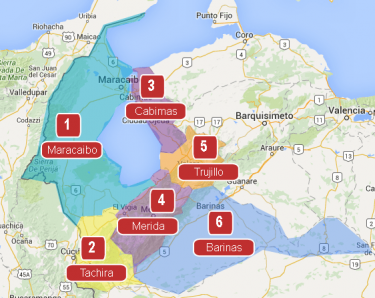
Raid Areas
This Mega Map Raid will be divided into 6 areas. Raid areas are shown on the map, with links to each area.