(→Hosts) |
|||
| (36 intermediate revisions by 3 users not shown) | |||
| Line 1: | Line 1: | ||
<div style="border: 1px solid rgb(170, 170, 170); margin: 4px; padding: .25em 1em .25em 1em; border-collapse: collapse; background: none repeat scroll 0% 0% rgb(249, 249, 249);"> | <div style="border: 1px solid rgb(170, 170, 170); margin: 4px; padding: .25em 1em .25em 1em; border-collapse: collapse; background: none repeat scroll 0% 0% rgb(249, 249, 249);"> | ||
[[File:BE_100.jpg|Right|150px]] | |||
<big>'''Belgium Speed Limit Mapraid 2016'''</big> | <big>'''Belgium Speed Limit Mapraid 2016'''</big> | ||
* Start: | * Start: 25 Mar 2016 19:00:00 UTC | ||
* End: | * End: 10 Apr 2016 12:00:00 UTC | ||
Date and Times are approximate. | Date and Times are approximate. | ||
If you would like to participate, please fill out this [ registration form]. | If you would like to participate, please fill out this [http://goo.gl/forms/A03U88A6oO registration form] . | ||
Registration is open until | Registration is open until 22 Mar 2016 00:00:00 UTC. | ||
<span style="color:#FF0000">Please do not make any edits in the raid area until after the raid begins.</span> This will allow us to get good mapraid statistics. | <span style="color:#FF0000">Please do not make any edits in the raid area until after the raid begins.</span> This will allow us to get good mapraid statistics. | ||
| Line 14: | Line 15: | ||
__TOC__ | __TOC__ | ||
== Goals == | == Goals == | ||
The main goal of this MapRaid is adding speed limits in the Walloon region of Belgium. | |||
[[File: | If you see basic errors on the map, like bad turns, you can fix them along the way. However, keep focused on the mapraid goal. If you see bigger problems that can be addressed later, contact a raid leader or record it in [[File:Google form icon.PNG|frameless|15px|link=//goo.gl/forms/eZM788DM5k]] [//goo.gl/forms/eZM788DM5k this form]. | ||
==Hosts== | ==Hosts== | ||
| Line 29: | Line 26: | ||
| {{Username|moweez}} || 6 || GC / MapRaid Coordinator | | {{Username|moweez}} || 6 || GC / MapRaid Coordinator | ||
|- | |- | ||
| {{Username|steveningelbrecht}} || 6 || GC | | {{Username|steveningelbrecht}} || 6 || GC / MapRaid Leader | ||
|- | |- | ||
| {{Username|tilto}} || 4 || LC | | {{Username|tilto}} || 4 || LC | ||
|- | |- | ||
| {{Username| | | {{Username|clubtratech}}|| 4 || LC | ||
|- | |||
| {{Username|wimvandierendonck}} || 4 || LC | |||
|- | |||
| {{Username|gertbroos}} || 4 || LC | |||
|- | |||
| {{Username|BenMimix}} || 4 || LC | |||
|} | |} | ||
== Communication == | == Communication == | ||
Because of the multiple languages used in the BeNeLux, the main language is English. There is help for translations. | |||
We will use Slack as the main communication platform. There is a special [https://wazebenelux.slack.com/archives/mr_be_sl Slack | When working in the raid area, please set yourself to visible in [[Waze_Map_Editor/Chat#Visible.2FInvisible|WME chat]]. Also, turn on the [[Map_Editor_Interface_and_Controls#Layers|Live Users]] layer. This will serve to collaborate smoothly and get quick help at your location if needed. | ||
We will use Slack as the main communication platform. There is a special [https://wazebenelux.slack.com/archives/mr_be_sl Slack Channel] for this raid. If you are not already part of the Benelux Slack team, you will be invited shortly before the Raid starts. <!--for later communication when raid started: If anything goes wrong and you didn't receive the invite when the raid is about to start, click here to get your [http://bit.ly/GetWazeSlackInvite Slack invitation] (choose WazeMapRaid). If you have trouble getting into the Slack team or channels, please reach out to one of the MapRaid organizers.--> | |||
== Raid Area == | == Raid Area == | ||
This MapRaid has only 1 group, working together in the southern part of Belgium. We kindly urge you to stay within the raid area. Use the [[link to be added|overlay]] as it | This MapRaid has only 1 group, working together in the southern part of Belgium. We kindly urge you to stay within the raid area. Use the [[link to be added|overlay]] as it roughly shows the border. The area neighbours France, Germany and the Netherlands. {{red|'''Please do not edit in other countries, even though you might have access'''}}. If something needs to be updated, inform one of the hosts who will contact the neighbouring country or use the form mentioned above. | ||
==Speed Limits guidelines== | |||
[[File:WME Settings.png|thumbnail|right|Change to metric for km]] | |||
<br /> | |||
| | <br /> | ||
| | |||
| | |||
<br | |||
Speed Limits in Belgium are expressed in km/h. Always use the '''metric units''' setting (see picture) in WME when working with speed limits. There is a handy [[User:Moweez/MR_Belgium_Speedlimits#Tools_for_this_mapraid|Speedhelper script]] that greatly facilitates entering speedlimits. | |||
{{clear}} | |||
The speed limits of the roads shall be verified with WME Street View. Unless differently indicated by road signs, the following speed limits shall be used on map: | |||
[[File:BE speedlimits.png|right]] | |||
<gallery> | |||
File:BE woonerfF12A.png|20 km/h | |||
File:BE 30kmF4A.png|30 km/h | |||
</gallery> | |||
* Living street (Woonerf / Zone résidentielle<!--https://en.wikipedia.org/wiki/Living_street-->): 20 km/h | |||
* School zones and cycling streets (fietsstraat / rue cyclabe): 30 km/h | |||
* Urban areas: (between white city boundary boards): 50 km/h | |||
* Rural areas: | |||
** Freeways: 120 km/h | |||
** Express ways, 4 lanes and a solid median: 120 km/h | |||
** All other roads outside cities: 90 km/h | |||
[[ | We will follow the guidelines on [[Benelux_Editing_Speed_Limits|Speed Limits in the BeNeLux]], with the following exception: | ||
If there is no streetview available, or you cannot find signs on streetview, you are allowed to enter the default speed limit by an 'educated guess': | |||
* Check if there is a school | |||
* Does it look like a city or village? | |||
* Does the road have separated GPS tracks? | |||
* etc. | |||
* | ''Notes'': | ||
* The limits shown above apply only if there are no other signs present, as the signs may prescribe a lower or a higher speed limit. | |||
* The sign for the city (with or without name) indicates a speed limit of 50 for the whole city. If another speed limit sign is within the borders of the city, it is only valid until the next intersection. | |||
* currently WME allows to specify only one speed limit for a single road segment. If a road has variable speed limits, we enter the lowest/highest/no speed limit (or map only the speed limit which is in effect most of the time during daylight hours (most hours of the day, days of the week). | |||
* | * Do not map '''advisory''' speed limits (generally blue rectangular sign with white lettering). | ||
* | |||
* Do not map special speed limits for special vehicles. Waze only supports speed limits for private passenger cars. | * Do not map special speed limits for special vehicles. Waze only supports speed limits for private passenger cars. | ||
* Where the speed limit changes, make it change in the map. A new junction may need to be added. But | * Where the speed limit changes, make it change in the map. A new junction may need to be added. But do not add a new junction for a speed limit if it will be within 20 meters. | ||
== Editing Resources == | == Editing Resources == | ||
| Line 143: | Line 104: | ||
{{red|Warning: If you copy information from unauthorized sources, you may be removed from this mapraid. Also, every segment you edited may be removed from the map. Copying information from copyrighted sources is illegal!}} | {{red|Warning: If you copy information from unauthorized sources, you may be removed from this mapraid. Also, every segment you edited may be removed from the map. Copying information from copyrighted sources is illegal!}} | ||
== Tools for this mapraid == | == Tools for this mapraid == | ||
=== Basic References === | === Basic References === | ||
;[[ | ;[[Benelux_WME_Quick-Start|Editing Quick-Start Guide]] | ||
;[[Benelux_WME_Quick-Start#How_to_make_a_permalink|How to make a Permalink]] ([//www.youtube.com/watch?v=xYmU6UPCiZs watch on YouTube]) | |||
;[[ | |||
;[http://drive.google.com/file/d/0B8WbeRGWGEOjQ1BvbHFtYlJSV2pIOVdyQlgtRmJzQUtHNjRz WME Reference Sheet<sup><small><nowiki>[PDF]</nowiki></small></sup>] | ;[http://drive.google.com/file/d/0B8WbeRGWGEOjQ1BvbHFtYlJSV2pIOVdyQlgtRmJzQUtHNjRz WME Reference Sheet<sup><small><nowiki>[PDF]</nowiki></small></sup>] | ||
:a printable double-sided tri-fold quick reference guide to some of the common topics used in WME. | :a printable double-sided tri-fold quick reference guide to some of the common topics used in WME. | ||
=== | === Highly Recommended Tools === | ||
Many tools are essential for good editing, and others make the editing process much easier. Highly recommended for this mapraid are:<br /> | |||
'''WME Color Highlights''' | |||
* This script adds color highlighting to segments and landmarks according to their status and type or other criteria. | |||
: Check the option for "No Speed Limit" and Uncheck the other highlight options. | : Check the option for "No Speed Limit" and Uncheck the other highlight options. | ||
: Segments with no speed limit or unverified speed limit will be highlighted orange. | : Segments with no speed limit or unverified speed limit will be highlighted orange. | ||
*Install the [//chrome.google.com/webstore/detail/wme-color-highlights/ijnldkoicbhinlgnoigchihmegdjobjc Chrome Extension] via Web Store, or the [//greasyfork.org/scripts/3206-wme-color-highlights addon] for use via [https://chrome.google.com/webstore/detail/tampermonkey/dhdgffkkebhmkfjojejmpbldmpobfkfo TamperMonkey]. | |||
: Install for [//greasyfork.org/scripts/3206-wme-color-highlights Firefox]. Needs [https://addons.mozilla.org/en-US/firefox/addon/greasemonkey Greasemonkey] to install and use. | |||
: tampermonkey/greasemonkey | |||
'''WME Speedhelper''' | |||
*[https://greasyfork.org/nl/scripts/13774-wme-speedhelper WME Speedhelper] has made inputting speed data easy, with the use of handy speedsign images. You just need to select one or more segments and click the speed you want in the menu left. If a segment isn't yet verified, don't worry, these check boxes will be automatically checked. | |||
*To use it, you need to have [https://chrome.google.com/webstore/detail/tampermonkey/dhdgffkkebhmkfjojejmpbldmpobfkfo TamperMonkey] (Chrome) or [https://addons.mozilla.org/en-US/firefox/addon/greasemonkey Greasemonkey] (Firefox) installed. | |||
{{red|!!KEEP MIND THAT YOU ARE RESPONSIBLE FOR THE USE OF ALL SCRIPTS!!}} | |||
There is a [[Scripts|wiki page]] and a [[Community_Plugins,_Extensions_and_Tools|forum]] with more information about scripts. | |||
====Specific tools for this MapRaid==== | |||
* There is an [https://greasyfork.org/en/scripts/18159-wme-belgium-sl Overlay] to view the boundaries of the RAID area via an extra layer. The areas are kept simple for smooth working in WME. Please note that the editing access rights can be more refined, especially around the border areas. | |||
*To use it, you need to have [https://chrome.google.com/webstore/detail/tampermonkey/dhdgffkkebhmkfjojejmpbldmpobfkfo TamperMonkey] (Chrome) or [https://addons.mozilla.org/en-US/firefox/addon/greasemonkey Greasemonkey] (Firefox) installed. | |||
===Advanced Scripts and Extensions=== | ===Advanced Scripts and Extensions=== | ||
'''WME Context Menu''' | |||
* When you right-click a segment, [//greasyfork.org/scripts/17087-wme-context-menu WME Context Menu] shows a pop-up menu that works with WME Speedhelper. Read more about WME Context Menu in [//www.waze.com/forum/viewtopic.php?f=819&t=178371 this forum topic] | |||
*To use it, you need to have [https://chrome.google.com/webstore/detail/tampermonkey/dhdgffkkebhmkfjojejmpbldmpobfkfo TamperMonkey] (Chrome) or [https://addons.mozilla.org/en-US/firefox/addon/greasemonkey Greasemonkey] (Firefox) installed. | |||
'''URO+''' | |||
[[File:URO+ MPH.PNG|thumb|right|100px|URO+ settings to find speed limit URs]] | |||
* With [//greasyfork.org/en/scripts/1952-uroverview-plus-uro URO+] you can search for URs with kmh. | |||
:In the "misc" tab, scroll down to custom markers, choose the last one, and type "kph" in the text box (instead of mph in the picture). | |||
:Speed Limit URs are the only ones we should be working with during this mapraid. | |||
*To use it, you need to have [https://chrome.google.com/webstore/detail/tampermonkey/dhdgffkkebhmkfjojejmpbldmpobfkfo TamperMonkey] (Chrome) or [https://addons.mozilla.org/en-US/firefox/addon/greasemonkey Greasemonkey] (Firefox) installed. | |||
'''WME Toolbox''' | |||
* This is a script that facilitate the process of editing maps in the WME. It has a toolbar that facilitates the process of removing unnecessary nodes, cut segments, locate "Soft Nodes", or nodes with undefined directions. Most important for this mapraid, it has a speed limit highlight option. | |||
* Install for [https://chrome.google.com/webstore/detail/wme-toolbox/ihebciailciabdiknfomleeccodkdejn?utm_source=chrome-app-launcher-info-dialog Chrome] or [http://gitlab.com/doctorkb/wme-toolbox-public/raw/master/Dist/Firefox/wmetoolbox.xpi Firefox]. | |||
== Results == | == Results == | ||
| Line 216: | Line 157: | ||
| text = Check back here after the raid is completed to see the results and achievements}} | | text = Check back here after the raid is completed to see the results and achievements}} | ||
[[Category:Mapraid]] | [[Category:Mapraid]] | ||
Latest revision as of 21:39, 21 March 2016
 Belgium Speed Limit Mapraid 2016
- Start: 25 Mar 2016 19:00:00 UTC
- End: 10 Apr 2016 12:00:00 UTC
Date and Times are approximate.
If you would like to participate, please fill out this registration form . Registration is open until 22 Mar 2016 00:00:00 UTC.
Please do not make any edits in the raid area until after the raid begins. This will allow us to get good mapraid statistics.
Goals
The main goal of this MapRaid is adding speed limits in the Walloon region of Belgium.
If you see basic errors on the map, like bad turns, you can fix them along the way. However, keep focused on the mapraid goal. If you see bigger problems that can be addressed later, contact a raid leader or record it in ![]() this form.
this form.
Hosts
| Editor | Rank | Roles |
|---|---|---|
| moweez (PM) | 6 | GC / MapRaid Coordinator |
| steveningelbrecht (PM) | 6 | GC / MapRaid Leader |
| tilto (PM) | 4 | LC |
| clubtratech (PM) | 4 | LC |
| wimvandierendonck (PM) | 4 | LC |
| gertbroos (PM) | 4 | LC |
| BenMimix (PM) | 4 | LC |
Communication
Because of the multiple languages used in the BeNeLux, the main language is English. There is help for translations.
When working in the raid area, please set yourself to visible in WME chat. Also, turn on the Live Users layer. This will serve to collaborate smoothly and get quick help at your location if needed.
We will use Slack as the main communication platform. There is a special Slack Channel for this raid. If you are not already part of the Benelux Slack team, you will be invited shortly before the Raid starts.
Raid Area
This MapRaid has only 1 group, working together in the southern part of Belgium. We kindly urge you to stay within the raid area. Use the overlay as it roughly shows the border. The area neighbours France, Germany and the Netherlands. Please do not edit in other countries, even though you might have access. If something needs to be updated, inform one of the hosts who will contact the neighbouring country or use the form mentioned above.
Speed Limits guidelines

Speed Limits in Belgium are expressed in km/h. Always use the metric units setting (see picture) in WME when working with speed limits. There is a handy Speedhelper script that greatly facilitates entering speedlimits.
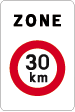
The speed limits of the roads shall be verified with WME Street View. Unless differently indicated by road signs, the following speed limits shall be used on map:

-
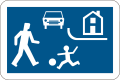
20 km/h
-
30 km/h


- Living street (Woonerf / Zone résidentielle): 20 km/h
- School zones and cycling streets (fietsstraat / rue cyclabe): 30 km/h
- Urban areas: (between white city boundary boards): 50 km/h
- Rural areas:
- Freeways: 120 km/h
- Express ways, 4 lanes and a solid median: 120 km/h
- All other roads outside cities: 90 km/h
We will follow the guidelines on Speed Limits in the BeNeLux, with the following exception:
If there is no streetview available, or you cannot find signs on streetview, you are allowed to enter the default speed limit by an 'educated guess':
- Check if there is a school
- Does it look like a city or village?
- Does the road have separated GPS tracks?
- etc.
Notes:
- The limits shown above apply only if there are no other signs present, as the signs may prescribe a lower or a higher speed limit.
- The sign for the city (with or without name) indicates a speed limit of 50 for the whole city. If another speed limit sign is within the borders of the city, it is only valid until the next intersection.
- currently WME allows to specify only one speed limit for a single road segment. If a road has variable speed limits, we enter the lowest/highest/no speed limit (or map only the speed limit which is in effect most of the time during daylight hours (most hours of the day, days of the week).
- Do not map advisory speed limits (generally blue rectangular sign with white lettering).
- Do not map special speed limits for special vehicles. Waze only supports speed limits for private passenger cars.
- Where the speed limit changes, make it change in the map. A new junction may need to be added. But do not add a new junction for a speed limit if it will be within 20 meters.
Editing Resources
Only use sources that are allowed by Waze.
Allowed sources:
- Satellite Imagery and Street-view from within WME.
- Websites from businesses.
- ...
NOT allowed sources:
- Info from other Maps.
- Google Maps
- Google Street-view.
Warning: If you copy information from unauthorized sources, you may be removed from this mapraid. Also, every segment you edited may be removed from the map. Copying information from copyrighted sources is illegal!
Tools for this mapraid
Basic References
- Editing Quick-Start Guide
- How to make a Permalink (watch on YouTube)
- WME Reference Sheet[PDF]
- a printable double-sided tri-fold quick reference guide to some of the common topics used in WME.
Highly Recommended Tools
Many tools are essential for good editing, and others make the editing process much easier. Highly recommended for this mapraid are:
WME Color Highlights
- This script adds color highlighting to segments and landmarks according to their status and type or other criteria.
- Check the option for "No Speed Limit" and Uncheck the other highlight options.
- Segments with no speed limit or unverified speed limit will be highlighted orange.
- Install the Chrome Extension via Web Store, or the addon for use via TamperMonkey.
- Install for Firefox. Needs Greasemonkey to install and use.
WME Speedhelper
- WME Speedhelper has made inputting speed data easy, with the use of handy speedsign images. You just need to select one or more segments and click the speed you want in the menu left. If a segment isn't yet verified, don't worry, these check boxes will be automatically checked.
- To use it, you need to have TamperMonkey (Chrome) or Greasemonkey (Firefox) installed.
!!KEEP MIND THAT YOU ARE RESPONSIBLE FOR THE USE OF ALL SCRIPTS!!
There is a wiki page and a forum with more information about scripts.
Specific tools for this MapRaid
- There is an Overlay to view the boundaries of the RAID area via an extra layer. The areas are kept simple for smooth working in WME. Please note that the editing access rights can be more refined, especially around the border areas.
- To use it, you need to have TamperMonkey (Chrome) or Greasemonkey (Firefox) installed.
Advanced Scripts and Extensions
WME Context Menu
- When you right-click a segment, WME Context Menu shows a pop-up menu that works with WME Speedhelper. Read more about WME Context Menu in this forum topic
- To use it, you need to have TamperMonkey (Chrome) or Greasemonkey (Firefox) installed.
URO+

- With URO+ you can search for URs with kmh.
- In the "misc" tab, scroll down to custom markers, choose the last one, and type "kph" in the text box (instead of mph in the picture).
- Speed Limit URs are the only ones we should be working with during this mapraid.
- To use it, you need to have TamperMonkey (Chrome) or Greasemonkey (Firefox) installed.
WME Toolbox
- This is a script that facilitate the process of editing maps in the WME. It has a toolbar that facilitates the process of removing unnecessary nodes, cut segments, locate "Soft Nodes", or nodes with undefined directions. Most important for this mapraid, it has a speed limit highlight option.
- Install for Chrome or Firefox.
Results
| Check back here after the raid is completed to see the results and achievements |