Goals
In order of importance:
- Solve URs and MPs
- Improve major connectivity
- Improve Wiki page
- Correct base map positioning
- Correct road naming
- Check and correct districts boundaries
Please read the Turkish wiki page for the specifics on editing!
Hosts
| editor | Rank | Role | |
|---|---|---|---|
| OrbitC (PM) | 6 | GC-MAPRAID/Coord Regional | |
| Moweez (PM) | 6 | Country manager |
Difficult-to-spot geometry nodes
We often use "doglegs" to force a '"turn" instruction instead of "keep" or "exit". his involves carefully placing the node very close to the intersection to achieve the correct angle, so it will be necessary to zoom in to see them. If you make a change, be sure to leave them with the same angle.
Local Guide
The current rules are rather new to our country, and many areas still need to upgrade for route continuity. Therefore, do not decrease road types without consulting a host. Road types are explained on the Turkey wiki page.
Elevation
In Turkey, elevation levels are like they are in reality. This sometimes requires the use of extra segments. It makes the LiveMap looks more real too. More importantly, it will be easier to close a bridge or tunnel without affecting traffic into nearby homes or businesses.
Guide to URs & MPs
Many of the URs we have in Venezuela are very old. But nothing is harmed if we try to communicate with the reporter. If a UR is over 3 months old, communicate with the reporter. if there is no response after three days, close the UR as Not Identified if you cannot solve it. You can use one of the Spanish URComments lists. If you don't speak Spanish, you can use a double language comment. If the reporter responds in Spanish, ask help from a local editor or use the translation channel in Slack.
Before closing a UR "Not Identified", make sure it really cannot be solved. The information in the UR (even forbidden turn with no additional messages) may be sufficient to resolve it, so do not close before checking.
Additionally, do not forget to leave a closing comment.
Editing Resources
Only use sources that are allowed by Waze, like Streetview from within WME. Google Maps (and its streetview) is NOT allowed. Websites from businesses are considered allowed sources. Other allowed sources are on the Turkey wiki page
Warning: If you copy information from unauthorized sources, you may be removed from the mMR and every segement you edited may be removed from the map. Copying information from copyrighted sources is illegal.
Communication
We will use #Slack Channels. There is a MapRaid general channel and also a channel for each raid group. Please be sure to join the slack WazeMapRaid Team and join the channels for the specific MapRaid and group you are assigned to. Groups are listed in the forum. If you are not already part of the WazeMapRaid slack team, Click here to get your Slack invitation. Be sure to choose WazeMapRaid to the MapRaid question. If you have trouble getting into the slack team and channels, please reach out to one of the MapRaid organizers.
Basic reference links
- New editor welcome page
- Waze Map Editor
- Best Map Editing Practice
- Editing manual
- Common editing mistakes
- How to make a Permalink
- All about using the WME Chat
- Community Plugins, Extensions and Tools where you'll find links and descriptions to most of the editing scripts available. Some of these are essential to good editing, and others make the editing process much easier. See the next section.
Highly Recommended Tools
Many tools are essential for good editing and others make the editing process much easier. Highly recommended are:
Validator
- This is a script that validates a map area in the Waze Map Editor, highlights issues and generates a very detailed report with U.S. wiki references and possible solutions. Keep in mind that guidelines of Venezuela (if available on the subject) precede over the guidelines of the U.S..
- Install for Chrome via Web Store.
- Install for Firefox. Needs Greasemonkey to install and use.
WME Toolbox
- This is a script that facilitate the process of editing maps in the WME. It has a toolbar that facilitates the process of removing unnecessary nodes, cut segments, locate "Soft Nodes", or nodes with undefined directions.
URComments
- a time and labor saving tool for responding to URs. Read the documentation. Needs TamperMonkey (Chrome) or Greasemonkey (Firefox) to install and use.
UR Overview Plus
- Provides a variety of features for URs (Update Requests), MPs(Map Problems) and Speed Cameras:
- URs MPs and Speed Cameras can be filtered according to a list of parameters
- URs may be increased [?] to show the number of comments for that UR
- For Chrome and Firefox: Install URO+. Needs TamperMonkey (Chrome) or Greasemonkey (Firefox) to install and use.
WME Colour Highlights
- Add colors to road segments to show their status. Places/areas can be highlighted according to their type.
- For Chrome and Firefox: Install. Needs TamperMonkey (Chrome) or Greasemonkey (Firefox) to install and use.
WME Chat Addon
- WME Chat Addon is a script that improves the WME chat. For a list of all its features: click here. Needs TamperMonkey (Chrome) or Greasemonkey (Firefox) to install and use.
¡¡PLEASE DO NOT MAKE BULK EDITS AND REMEMBER THAT YOU ARE RESPONSIBLE FOR THE USE OF ALL SCRIPTS!!
Specific tools for this MapRaid
- The teams overlay for the Venezuela MapRaid: Serves to indicate the group editing areas in WME. To use it, you need to have TamperMonkey (Chrome) or Greasemonkey (Firefox) installed.
- WME validator localization for Venezuela with Venezuela-specific rules. To use it, you need to have TamperMonkey (Chrome) or Greasemonkey (Firefox) installed.
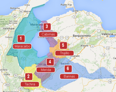
Raid Areas
This Mini Map Raid has only 1 group. Raid areas are shown on the map, with links to each area. </translate>