'''This is the preferred method for closing roads due to its safety and visibility to the Wazers.'''
This feature allows editors to temporarily prevent routing over specific segments, without having to make any changes to, or damage those segments and their junctions.
Real Time Closures can be added to Waze in four ways:
Real Time Closures can be added to Waze in four ways:
Line 81:
Line 85:
===Closure feature restrictions===
==== Closure feature permissions ====
This feature is restricted to rank 5 editors and above, unless otherwise decided by the local community. Global champs also have the ability to allow users of varioius levels aceess to the feaure. If you would like to request access, contact a member of the community in the [http://www.waze.com/forum/viewforum.php?f=663 Waze Community Forums].
This feature is restricted to rank 5 editors and above, unless otherwise decided by the local community. Global champs also have the ability to allow users of varioius levels aceess to the feaure. If you would like to request access, contact a member of the community in the [http://www.waze.com/forum/viewforum.php?f=663 Waze Community Forums].
Alternatively, If you do not have the required rank to access the Closure feature in WME, you can ask a higher ranking editor to implement the closures for you. Your country may have a streamlined monitored process for this, or it can be submitted like any other unlock/update request. ''In the USA the [http://docs.google.com/forms/d/1oGINt4UEkBV0Par5VCingXzTZpJq9KjG8GbZpGqbRow/viewform Road Closures Form (USA)] is used for example.''
Alternatively, If you do not have the required rank to access the Closure feature in WME, you can ask a higher ranking editor to implement the closures for you. Your country may have a streamlined monitored process for this, or it can be submitted like any other unlock/update request. You can also ask a higher editor directly in a [[PM]], or [[WME Chat]]. ''In the USA the [http://docs.google.com/forms/d/1oGINt4UEkBV0Par5VCingXzTZpJq9KjG8GbZpGqbRow/viewform Road Closures Form (USA)] is used for example.''
===How use the the "Add a closure" feature===
==== How to use the the "Add a closure" feature ====
With this tool, closures can be entered directly in WME, and is visible almost immediately in the client and Livemap. It is displayed prominently on the map as a closure alert, and with red and white candy stripe lines along the closed segments.
With this tool, closures can be entered directly in WME, and is visible almost immediately in the client and Livemap. It is displayed prominently on the map as a closure alert, and with red and white candy stripe lines along the closed segments.
'''This is the preferred method for closing roads due to its safety and visibility to the Wazers.'''
# Select the segments you want to close.
# Select the segments you want to close.
# Click the {{key press|Add Closure}} button in the left panel.
# Click the {{key press|Add Closure}} button in the left panel.
# Click to {{key press|+ Add Closure}} and fill out the fields shown:
# Click to {{key press|+ Add Closure}} and fill out the fields shown:
::'''Location'''- This field will auto-populate to name of affected street. If multiple streets are selected, add a general description of the area (name of the road, the interchange, or the area if several roads in a known area are being closed). This Section is NOT viewable in the client, only in the WME.
::'''Location''' - This field will auto-populate to name of affected street. If multiple streets are selected, add a general description of the area (name of the road, the interchange, or the area if several roads in a known area are being closed). This section is NOT view-able in the client app, it is only seen in the WME.
::'''Reason''' - This section will be viewable in both the client and the LiveMap. Once supported, hashtags will go here. If no hashtag is provided, write a description of event here.
::'''Reason''' - This section will be view-able in both the client app and the LiveMap. Write a description of closure / event here. ''Once supported, #hashtags will go here.''
::'''Direction''' - Closure direction should be noted carefully (using the A and B nodes for reference). Close one way direction on a two way road here.
::'''Event''' - This field is not currently active, please ignore.
::'''Start/End Date & Time''' - Enter date/time the closure will remain active (the start date can be a date in the past). Enter local time for area of map you are editing. Format is 24-hour clock and YYYY-MM-DD. '''{{red|NOTE:}} End date can not be more than 183 days after the start date.''' (see [[#Start and end time settings|below]] for more information.)
::'''Direction''' - Closure direction should be noted carefully. Close one way direction on a two way road here.
[[File:Add closure details.png|center]]
::'''Event''' - Field is not currently active, please ignore.
::'''Start/End Date & Time''' - Enter date/time the closure will remain active (this can be a date in the past). Enter local time for area of map you are editing. Format is 24-hour clock and YYYY-MM-DD. End date can not be more than 183 days after the start date. (see below for more information.
[[File:Add closure details.png|center]]
==== Saving your work ====
This feature allows editors to temporarily prevent routing over specific segments, without having to make any changes to, or damage those segments and their junctions.
'''Save & Check''' in the live map. Active closures will appear with red closure icons in WME, and with closure alerts bubbles and red and white ''(candy stripe)'' road segment highlighting in Livemap immediately.
====Saving your work====
Inactive closures will appear with grey closure icons in WME only. They do not appear at all in Livemap or the Waze app.
'''Save & Check''' in the live map. Active closures will appear with red closure icon, inactive closures will appear in grey.
A closure can not be entered along with any other saves, similar to House Numbers. If you have any edits pending a save, and try to add a Temporary Closure you will get an error at the end. Be sure to save before trying to add a Temporary Closure.
A closure can not be entered along with any other saves, similar to House Numbers. If you have any edits pending a save, and try to add a Temporary Closure you will get an error at the end. Be sure to save before trying to add a Temporary Closure.
====Closures not showing====
====Closures not showing====
Temporary Closures entered using this feature {{u|are not subject to waiting for a [[tile update]]}}, they will go live almost immediately. However, if you enter a Temporary Closure for a segment which has been modified enough (e.g. changed the segment ID, node ID, or junction location) since the last tile update, the Temporary Closure will not save until the new segment changes go live.
Real-Time Closures entered using this feature {{u|are not subject to waiting for a [[tile update]]}}, they will go live almost immediately. However, if you enter a Real-Time Closure for a segment which has been modified enough (e.g. changed the segment ID, node ID, or junction location) since the last tile update, the Real-Time Closure will not save until the new segment changes go live.
If entered through a Google Sheet the alerts will likely show in the new location of the nodes, but the candy stripe and routing effects won't be implemented until the segment changes are live.
If entered through a Google Sheet the alerts will likely show in the new location of the nodes, but the candy stripe and routing effects won't be implemented until the segment changes are live.
To protect against this, if you try to close a new or modified segment before the tiles update, the closure will not save and WME will display an error '''{{red|(!) Element Segment with ID xxxxxxxx was not f{{ReturnToEditingManual}}{{mbox|type=important|text=DO NOT use Closures or Partial Restrictions for ''lane closures''. Closures are only to be used when a segment is completely closed to all public through traffic temporarily. Partial Restrictions can be used when a segment is completely closed to specific types of vehicles.}}
To protect against this, if you try to close a new or modified segment before the tiles update, the closure will not save and WME will display an error '''{{red|(!) Element Segment with ID xxxxxxxx was not found (probably deleted).}}''' Wait till after the changes are included in a tile build, and then enter the closure again and it should save.
=== WME closure feature guidance ===
==== Closing multiple segments ====
Real-Time Closures can be added to multiple segments simultaneously by selecting all the affected segments first. {{Red|Be careful}} to verify all the segments after you save that the Real-Time Closures were added properly. ''It's been reported before when multiple Real-Time Closures were added at once, that some of the segments either weren't closed, or had incorrect details in the closure (e.g. direction).''
==== Editing closed segments ====
===WME closure feature guidance===
{{Red|'''NOTE:'''}} If a segment is closed using this feature, the segment will not be editable by any editors - regardless of rank - while the closure is in effect. This is by design, to prevent any changes to segment and junction node IDs which will corrupt the closure.
====Closing multiple segments====
If you need to edit the segment, you will have to first remove the Temporary Closure ''(copy the details first)'', then modify the segment and save. Depending on the type of edit you can either replace now, otherwise you will need to wait for a tile update before being able to add a new Temporary Closure. Add a new Temporary Closure with the details you copied to the appropriate segments.
Temporary Closures can be added to multiple segments simultaneously by selecting all the affected segments first. {{Red|Be careful}} to verify all the segments after you save that the Temporary Closure were added properly. ''It's been reported before when multiple Temporary Closures were added at once, that some of the segments either weren't closed, or had incorrect details in the closure (e.g. direction).''
====Editing closed segments====
{{Red|'''NOTE:'''}} If a segment is closed using this feature, the segment will not be editable by any editors - regardless of rank - while the closure is in effect. This is by design, to prevent any changes to segment and junction IDs which will corrupt the closure.
====Closures due to constructions/closed roads====
====Closures due to constructions/closed roads====
{{mbox|image=[[File:Clock.png|40px]]|text=Be careful choosing closure times. 00:00 is the first minute of a day, 23:59 is the last minute of a day. A closure ending on Jan 1st at 00:00 will leave the road open for the entire day of Jan 1st, while 23:59 would leave the road closed for that entire day. ''To prevent ambiguity try using 00:01 instead of 00:00 as a closure time.''}}
*Real-time Closures are active for the full minute they are set for.
** A Closure set for Start: 03:00 - End: 03:01, will actually be closed for 119 seconds, from 03:00:00 - 03:01:59.
** A closure set for Start: 03:00, End: 04:00, will actually be closed for 60 minutes and 59 seconds, from 03:00:00 - 04:00:59.
===== Setting long-term closures =====
* Temporary Closures must not be longer than 6 calendar months (183 days to be precise).
* Temporary Closures must not be longer than 6 calendar months (183 days to be precise).
** To enter a Temporary Closure longer than 6 months, split it into multiple Temporary Closures. Each Temporary Closure entered should be less than 6 months. E.g. A one year Temporary Closure from 2011-12-01 through 2015-11-30 can be entered as two individual Temporary Closures.
** To enter a Temporary Closure longer than 6 months, split it into multiple Temporary Closures. Each Temporary Closure entered should be less than 6 months. E.g. A one year Temporary Closure from 2011-12-01 through 2015-11-30 can be entered as two individual Temporary Closures.
Line 147:
Line 162:
**# 2015-06-01 - 2015-11-30 (183 days)
**# 2015-06-01 - 2015-11-30 (183 days)
====Start and end time settings====
{{mbox|image=[[File:Clock.png|40px]]|text=Be careful choosing closure times. 00:00 is the first minute of a day, 23:59 is the last minute of a day. A closure ending on Jan 1st at 00:00 will leave the road open for the entire day of Jan 1st, while 23:59 would leave the road closed for that entire day. ''To prevent ambiguity try using 00:01 instead of 00:00 as a closure time.''}}
*Real-time Closures are active for the full minute they are set for.
** A Closure set for Start: 03:00 - End: 03:01, will actually be closed for 119 seconds, from 03:00:00 - 03:01:59.
** A closure set for Start: 03:00, End: 04:00, will actually be closed for 60 minutes and 59 seconds, from 03:00:00 - 04:00:59.
Do NOT use any of the tools discussed on this page for lane closures. These methods of controlling traffic flow are only to be used when a segment is completely closed to all public through traffic temporarily.
Oftentimes roads on the map need to be closed for a variety of reasons ranging from planned construction or a large-scale event to emergency closures for accidents or natural disasters. These are called Real-Time Closures, and will be discussed in detail on this page.
Controlling traffic flow
There are several mechanisms to prevent Waze from routing traffic over specific roads. Which method is used depends on the reason traffic needs to be prevented from using that road. Here is a brief overview of the various mechanisms available for controlling traffic flow on specific roads, for specific details on any of these mechanisms, please see the corresponding wiki pages linked below.
Real time closures (This page) — Should be used to temporarily prevent any routing through segments without actually modifying the segments, or their turn restrictions. These display in the client and Livemap with alerts and candy stripes on the segments notifying users of the closures in real-time (no wait for a tile update), and preventing routing. Due its' safety (protecting the map), and its visibility (in the client and Livemap), this is the preferred method of closing a road. Real-Time Closures can be submitted in a variety of methods discussed in detail further on this page:
Partial restrictions —AKA Scheduled or Time-Based Restrictions. Used when turns or roadways are restricted for certain times of day, days of the week, vehicle types, etc. It has the ability to only restrict during a specific date range, but should NOT be used in place of Mega Traffic Events or Real-Time Road Closures.
Road types — Certain road types (Private, Parking Lot Road, Dirt Road / 4X4 Trail) intrinsically prevent routing and should be used when appropriate for permanent situation.
Disconnect road segments — Road segments should only be physically disconnected if the road is no longer intended to connect or is being permanently removed. When a road is disconnected, it becomes absolutely unroutable, and all stored speed data for the junctions are lost. This should be done with the support of a senior editor. In the past, this method was used for longer term construction projects, but now the Road Closure feature should be used.
Real time closures
This is the preferred method for closing roads due to its safety and visibility to the Wazers.
This feature allows editors to temporarily prevent routing over specific segments, without having to make any changes to, or damage those segments and their junctions.
Real Time Closures can be added to Waze in four ways:
The editing community can be informed about these closures by:
URs/MPs submitted through the app
Knowledge of local happenings
Notification from the local community / Waze Major Traffic Event Team
Long term closures
As mentioned above, if the closure is part of an event which will be impacting a large number of people in your area (i.e. - major highway closed, city-wide marathon, natural disaster) please be sure to submit the MTE form first. The closures should be submitted using the MTE sheets provided. This way Waze is able to track the closures and help spread the word. Only if Waze decides not to support the event, or if you don't have at least one weeks advance notice should you submit these closures through other methods.
How to submit a closure
This slideshow was prepared by Waze staff to show how to add a closure in WME. It contains information on which segments to select as part of a closure as well. The information in this slide show is also presented throughout this page in text.
Major traffic events
If a road closure is part of a larger event, it can be submitted to Waze as a Major Traffic event, or MTE. MTEs are generally determined by the scale of the event and how many people will be impacted.
To notify Waze of a coming event in your area, use the MTE Submission Form.
Helpful information to have for submissions are as follows:
Name of Event
Website for event
Roads which will be effected (not necessary)
Location
Start and End Date
Start and End Time (if available)
All MTE submissions are posted to the Waze Mini Site(if the mini site gives an error try refreshing the page) so that other editors in your area can find the name for an event and mark the closure consistently. The closures for each MTE are submitted in a unique Google Sheets spreadsheet. If you need access to a particular event spreadsheet, request access in the spreadsheet and it will be granted by Waze HQ.
If your event is going to receive further support as an MTE, or if more information is needed, Waze will be in touch after the form is submitted. Waze further supports some events by providing local push notifications, inbox messages, social media announcements and/or website features on the Major Events page on Waze.com.
If Waze notifies you that your submitted Major Traffic Event will not be supported, or if you have less than one weeks advance notice of the closure, you should submit the closure through one of the other Real-Time Closure methods.
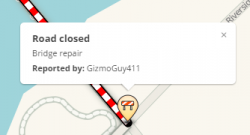
Report closure feature in the Waze app
Users in the client app can mark an unexpected road closure they see while driving. It is typically used for unexpected, short term closures of up to a few days. This feature requires multiple users to be at the location to enter the same road closure information on the map before it will be seen by other drivers.
Instructions on how to use this feature in the Waze app is available in the Waze Help Center.
Closure feature in the WME
Closure feature permissions
This feature is restricted to rank 5 editors and above, unless otherwise decided by the local community. Global champs also have the ability to allow users of varioius levels aceess to the feaure. If you would like to request access, contact a member of the community in the Waze Community Forums.
Alternatively, If you do not have the required rank to access the Closure feature in WME, you can ask a higher ranking editor to implement the closures for you. Your country may have a streamlined monitored process for this, or it can be submitted like any other unlock/update request. You can also ask a higher editor directly in a PM, or WME Chat. In the USA the Road Closures Form (USA) is used for example.
How to use the the "Add a closure" feature
With this tool, closures can be entered directly in WME, and is visible almost immediately in the client and Livemap. It is displayed prominently on the map as a closure alert, and with red and white candy stripe lines along the closed segments.
Select the segments you want to close.
Click the Add Closure button in the left panel.
Click to + Add Closure and fill out the fields shown:
Location - This field will auto-populate to name of affected street. If multiple streets are selected, add a general description of the area (name of the road, the interchange, or the area if several roads in a known area are being closed). This section is NOT view-able in the client app, it is only seen in the WME.
Reason - This section will be view-able in both the client app and the LiveMap. Write a description of closure / event here. Once supported, #hashtags will go here.
Direction - Closure direction should be noted carefully (using the A and B nodes for reference). Close one way direction on a two way road here.
Event - This field is not currently active, please ignore.
Start/End Date & Time - Enter date/time the closure will remain active (the start date can be a date in the past). Enter local time for area of map you are editing. Format is 24-hour clock and YYYY-MM-DD. NOTE: End date can not be more than 183 days after the start date. (see below for more information.)
Saving your work
Save & Check in the live map. Active closures will appear with red closure icons in WME, and with closure alerts bubbles and red and white (candy stripe) road segment highlighting in Livemap immediately.
Inactive closures will appear with grey closure icons in WME only. They do not appear at all in Livemap or the Waze app.
A closure can not be entered along with any other saves, similar to House Numbers. If you have any edits pending a save, and try to add a Temporary Closure you will get an error at the end. Be sure to save before trying to add a Temporary Closure.
Closures not showing
Real-Time Closures entered using this feature are not subject to waiting for a tile update, they will go live almost immediately. However, if you enter a Real-Time Closure for a segment which has been modified enough (e.g. changed the segment ID, node ID, or junction location) since the last tile update, the Real-Time Closure will not save until the new segment changes go live.
If entered through a Google Sheet the alerts will likely show in the new location of the nodes, but the candy stripe and routing effects won't be implemented until the segment changes are live.
To protect against this, if you try to close a new or modified segment before the tiles update, the closure will not save and WME will display an error (!) Element Segment with ID xxxxxxxx was not found (probably deleted). Wait till after the changes are included in a tile build, and then enter the closure again and it should save.
WME closure feature guidance
Closing multiple segments
Real-Time Closures can be added to multiple segments simultaneously by selecting all the affected segments first. Be careful to verify all the segments after you save that the Real-Time Closures were added properly. It's been reported before when multiple Real-Time Closures were added at once, that some of the segments either weren't closed, or had incorrect details in the closure (e.g. direction).
Editing closed segments
NOTE: If a segment is closed using this feature, the segment will not be editable by any editors - regardless of rank - while the closure is in effect. This is by design, to prevent any changes to segment and junction node IDs which will corrupt the closure.
If you need to edit the segment, you will have to first remove the Temporary Closure (copy the details first), then modify the segment and save. Depending on the type of edit you can either replace now, otherwise you will need to wait for a tile update before being able to add a new Temporary Closure. Add a new Temporary Closure with the details you copied to the appropriate segments.
Closures due to constructions/closed roads
For road construction situations, refer to that article for additional specific information.
Segment direction for one-way closures
If only some of the segments are one-way, or some one-way segments are in opposing direction (B-A, A-B), you can set the Closure as two-way for all the segments. When you save you will see an error line for each direction of a closed segment which failed to save because the segment is one-way. You can ignore the error, and all your segments should be closed in all possible directions. (Be sure to double check them all.)
Junctions and cross traffic
When adding a Temporary Closure consider whether any cross traffic will be blocked as well.
If traffic going across your Temporary Closure at a junction must be blocked as well, you will need to close one of the cross street segments as well.
You should close the segment leading away from the Temporary Closure. If the cross street is a two way street, close only the shorter segment.
When closing a two way cross street segment, only set the Temporary Closure to the direction leading away from the Temporary Closure.
1.2.3.
Start and end time settings
Be careful choosing closure times. 00:00 is the first minute of a day, 23:59 is the last minute of a day. A closure ending on Jan 1st at 00:00 will leave the road open for the entire day of Jan 1st, while 23:59 would leave the road closed for that entire day. To prevent ambiguity try using 00:01 instead of 00:00 as a closure time.
Real-time Closures are active for the full minute they are set for.
A Closure set for Start: 03:00 - End: 03:01, will actually be closed for 119 seconds, from 03:00:00 - 03:01:59.
A closure set for Start: 03:00, End: 04:00, will actually be closed for 60 minutes and 59 seconds, from 03:00:00 - 04:00:59.
Setting long-term closures
Temporary Closures must not be longer than 6 calendar months (183 days to be precise).
To enter a Temporary Closure longer than 6 months, split it into multiple Temporary Closures. Each Temporary Closure entered should be less than 6 months. E.g. A one year Temporary Closure from 2011-12-01 through 2015-11-30 can be entered as two individual Temporary Closures.
2014-12-01 - 2015-05-31 (182 days)
2015-06-01 - 2015-11-30 (183 days)
Usernames and closures
Adding a Temporary Closure does not put your name as the last editor for the segment (Updated By: user (#)), however you can see who added a closure by looking at the alert in livemap or the client.
Real time closures vs. partial restrictions (time based restrictions)
Many major roads have ongoing restrictions, which are based on day of the week or time of day. Some examples include:
If a road is closed with a Real Time Closure, there is no need to duplicate the Closure with an additional Partial Restriction for traveling across the segment, or change any turn restrictions. (This also helps preserve the map, as soon as the Temporary Closure expires, the map will route as it's supposed to.)


 2.
2.  3.
3.