Places
Create a Place

Click at the top of the Waze Map Editor to add a Place on the ![]() icon and then choose one of the displayed place categories from the list. Finally, a choice must be made between a point and a area place.
icon and then choose one of the displayed place categories from the list. Finally, a choice must be made between a point and a area place.
A submenu is displayed for some place categories.

Puntplaatsen
Puntplaatsen worden niet weergegeven in de app. Ze worden alleen gebruikt om Wazers te helpen locaties te vinden, vooral wanneer ze niet of verkeerd worden vermeld in andere zoekmachines. Omdat de plaatsen opgezocht/geselecteerd kunnen worden vanuit de app, zijn de nauwkeurige positionering van een puntplaats en het verstrekken van een volledig adres (inclusief straatnummer) beide uiterst belangrijk.
In de editor wordt een puntplaats als een kleine circel vertoond met uizondering van een residential place, die als een kleine driehoek wordt getoond.
![]() Standaard puntplaats
Standaard puntplaats
![]() Modified point, pending for approval
Modified point, pending for approval
The Waze routing server will navigate the Wazer onto the segment which is physically closest to where the Point is placed.
The Point Marker is the stop point. Typically, if the Place is inside a building, the marker should be located at or near the location's main entrance door. Try to imagine where you would stop to drop someone off for this location.
Icons and dots
Icons or dots are colored respecting the category.
For better visibility, now dots vs icons will be displayed according to zoom level, namely:
- Zoom level 18-22: icon
- Zoom level 17: dot with icon on hover
- Zoom level 16 and below: nothing.
Area Places

Elke area plaats heeft een toegangspunt (entry point) die standaard gecentreerd is. Het pijltje in bijgaande afbeelding. Dit punt kan worden verplaatst naar waar je moet aankomen of waar je moet parkeren: Probeer je hierbij voor te stellen waar je zou stoppen om iemand met deze bestemming af te zetten.
Als een toegangspunt aan een Walking trail (WT) wordt gekoppeld, leg deze dan bovenop de WT. Anders kan het gebeuren dat er toch naar een berijdbaar segment in de buurt wordt geleid.
Elke Areaplaats heeft ook een verplaatsingshendel waarmee je de plaats kunt verschuiven. Als het gebied zelf moet worden gewijzigd, klikt u op de plaats om het te selecteren. Gebruik de geometrie knooppunten om de vorm aan te passen. Om een areaplaats te verplaatsen zonder de vorm te veranderen, versleep je de plaats met het ![]() verplaatsingshendel-pictogram.
verplaatsingshendel-pictogram.
Residential or Private Places

Public Places can be turned into private Places, but private Places cannot be turned into public Places. Use the link located under the buttons for Point or Area in the menu, to convert Places mistakenly labeled as public into private.
More on this topic see the Residential Place page.
Combined Places

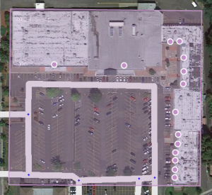
Point Places within an Area Place are allowed and mostly used for shops in a shopping mall, faculties within a University campus, etc.. Avoid Areas within Areas, as this may become confusing on the client's display.
When to use Area or Point
Parking Lots and Gas Stations are always drawn as Area Place. Most other places are generally drawn as a Point Place, except when they are large and distinctive enough to help in the orientation during driving, which will often be the case with an Event Center, Factory, Hospital, Office, Camping, Shopping malls, Museums (e.g.,Rijksmuseum, Amsterdam), Monuments (e.g., Mardasson, Bastogne), Schools, Tourist Site, Attraction, Sports Court or Stadium and natural features. They are mapped as areas at the (building) outline and usually don't cover streets.
The category table provides a guideline to choose between point and area places, via their category, subcategory and likely area size.
Places details
Any Place - Point or Area - should contain as much information as possible.
General tab
- If there are more than one places defined for one POI, link the external provider to the most important one. Example: Underground station with more than one entrance defined, use the main entrance.
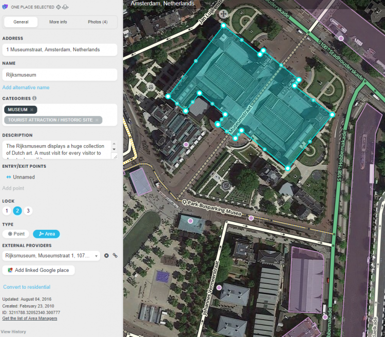
In the picture below you see an example from the Rijksmuseum in Amsterdam.

More Info tab
You can provide the website address and phone number in the “More Info” tab, where you can also select optional services, like Wifi, Toilets, Terrace or Parking for customers (not to be drawn separately!). Information in this tab are shown in the search results. From there you can click the website address or telephone number and activate your browser or phone function. Therefore, they should be in a usable format:

Website
- The website address is best written as www.address.extension, like www.casca.nl. Leave out http:// or https://.
- If the website is multilingual and a choice has to be made, if possible default to English.
Telephone
- Telephone numbers should best be written in international format: Generally, the number consists of the country code, followed by the area code (without 0), and than the subscribers number, all without dashes, slashes, brackets and the like. Formatting spaces are allowed but not necessary. One exception: don't preceed 0800 and 0900 numbers with the country code.
- +31 AA BBBBBBBB, or +31 AAA BBBBBBB for landlines,
- +31 6 CBBBBBBB for mobile numbers
- 0800 BBBBBB or 0900 BBBBBB for 0800 and 0900 numbers
Opening hours
- Add if possible the opening hours.
Photos tab
Lock Levels
Please consider that places that are fundamental to the functioning of Waze, such as Parking Lots, should be locked at least to Level 2 (or higher), to prevent loss of data due to automatic acceptance of submissions. See also the page on Place categories.
Trusted editor
Beginnende editors hebben goedkeuring nodig van een editor met level 2 of hoger voor de plaatsen die zij aanmaken, totdat ze na een aantal goedgekeurde plaats edits de trusted status bereiken.
Aspects
- Place update request
- Flagged place
- Misplaced ad pins form is intended for reporting issues with advertised places that are wrongly placed on the map. Requests of L4 editors are automatically approved by Waze.