Dmcrandall (talk | contribs) (Moved City of Maricopa link to Pinal County and updated the url.) |
m (Updated the links to Cochise County's Online ArcGIS resources) |
||
| Line 1: | Line 1: | ||
<!-- This page is only viewed directly through a link from the state's "unique portion" page. Content on this page will be viewed in its entirety.--><noinclude>{{:USA/CommonState/ReturnPurge|{{SubPage2}}}}<br/></noinclude><!-- | <!-- This page is only viewed directly through a link from the state's "unique portion" page. Content on this page will be viewed in its entirety.--><noinclude>{{:USA/CommonState/ReturnPurge|{{SubPage2}}}}<br /></noinclude><!-- | ||
------ DO NOT MODIFY ABOVE THIS LINE -------- DO NOT MODIFY ABOVE THIS LINE ------> | ------ DO NOT MODIFY ABOVE THIS LINE -------- DO NOT MODIFY ABOVE THIS LINE ------> | ||
| Line 7: | Line 7: | ||
The following are statewide and county mapping and GIS links. For each county, countywide resources are listed first. City-specific resources are then listed alphabetically by city name. This list is not comprehensive. If a city is not listed, then search for its official site. If you find a mapping or GIS resource, then please consider adding it to this page. | The following are statewide and county mapping and GIS links. For each county, countywide resources are listed first. City-specific resources are then listed alphabetically by city name. This list is not comprehensive. If a city is not listed, then search for its official site. If you find a mapping or GIS resource, then please consider adding it to this page. | ||
== Mapping and GIS Links == | ==Mapping and GIS Links== | ||
<imagemap>Image:ArizonaCountymap.gif|500px| | <imagemap>Image:ArizonaCountymap.gif|500px| | ||
| Line 30: | Line 30: | ||
Click within the borders of any county in the map to jump to that county's resource list. | Click within the borders of any county in the map to jump to that county's resource list. | ||
=== Countrywide === | ===Countrywide=== | ||
---- | ---- | ||
* [http://pe.usps.gov/text/pub28/28apc_002.htm '''United States Postal Service'''] | *[http://pe.usps.gov/text/pub28/28apc_002.htm '''United States Postal Service'''] | ||
<blockquote>The table lists examples of suffix forms that are primary street suffix names, common street suffixes or suffix abbreviations, and recommended official Postal Service standard suffix abbreviations. See also [https://wiki.waze.com/wiki/Abbreviations_and_acronyms#Standard_suffix_abbreviations '''Waze Standard Suffix Abbreviations]</blockquote> | <blockquote>The table lists examples of suffix forms that are primary street suffix names, common street suffixes or suffix abbreviations, and recommended official Postal Service standard suffix abbreviations. See also [https://wiki.waze.com/wiki/Abbreviations_and_acronyms#Standard_suffix_abbreviations '''Waze Standard Suffix Abbreviations''']</blockquote> | ||
=== Statewide === | ===Statewide=== | ||
---- | ---- | ||
* [http://www.arcgis.com/home/webmap/viewer.html?webmap=b560059ae13b49d9b9161e4c6abda509&extent=-119.3098,28.2181,-103.083,37.2136 '''ArcGIS Functional Classification'''] | *[http://www.arcgis.com/home/webmap/viewer.html?webmap=b560059ae13b49d9b9161e4c6abda509&extent=-119.3098,28.2181,-103.083,37.2136 '''ArcGIS Functional Classification'''] | ||
<blockquote>This is the Arizona Department of Transportation APLAN ArcGIS Functional Classification map. This is the interactive map that all Arizona editors are to use when establishing FC implementation into the Waze Map Editor.</blockquote> | <blockquote>This is the Arizona Department of Transportation APLAN ArcGIS Functional Classification map. This is the interactive map that all Arizona editors are to use when establishing FC implementation into the Waze Map Editor.</blockquote> | ||
| Line 57: | Line 57: | ||
<blockquote>Useful for verifying current Gas Station statuses.</blockquote> | <blockquote>Useful for verifying current Gas Station statuses.</blockquote> | ||
=== Counties === | ===Counties=== | ||
---- | ---- | ||
==== Apache County ==== | ====Apache County==== | ||
* [http://gis.co.apache.az.us/mapserver2014/mapviewerajax/?WEBLAYOUT=Library://Steve/Web+layouts/ApacheCounty.WebLayout&LOCALE=en&USERNAME=Anonymous '''''Apache County'' Maps'''] | *[http://gis.co.apache.az.us/mapserver2014/mapviewerajax/?WEBLAYOUT=Library://Steve/Web+layouts/ApacheCounty.WebLayout&LOCALE=en&USERNAME=Anonymous '''''Apache County'' Maps'''] | ||
<blockquote>Provides street names, and other information through various layers.</blockquote> | <blockquote>Provides street names, and other information through various layers.</blockquote> | ||
==== Cochise County ==== | ====Cochise County==== | ||
* '''[https:// | *'''[https://gis-cochise.opendata.arcgis.com/app/cb4fc995f40043e29e665d9e88007f08 ''Cochise County'' Interactive Map]''' | ||
<blockquote>Cochise County Interactive Mapping Application. This will eventually replace the other ArcGIS maps for Cochise County</blockquote> | |||
* '''[https://gis-cochise.opendata.arcgis.com/app/37d793d478664634b4de3ad8042f248a ''Cochise County'' Parcel Viewer]''' | |||
<blockquote>Provides street names, house number assignments, parcel ownership, names of natural features, names of city facilities, and names of educational, medical, and religious institutions.</blockquote> | <blockquote>Provides street names, house number assignments, parcel ownership, names of natural features, names of city facilities, and names of educational, medical, and religious institutions.</blockquote> | ||
==== Coconino County ==== | ====Coconino County==== | ||
* '''[https://cochise.maps.arcgis.com/apps/webappviewer/index.html?id=37d793d478664634b4de3ad8042f248a ''Coconino County'' Parcel Viewer]''' | *'''[https://cochise.maps.arcgis.com/apps/webappviewer/index.html?id=37d793d478664634b4de3ad8042f248a ''Coconino County'' Parcel Viewer]''' | ||
<blockquote>Provides street names, house number assignments, parcel ownership, names of natural features, names of city facilities, and names of educational, medical, and religious institutions.</blockquote> | <blockquote>Provides street names, house number assignments, parcel ownership, names of natural features, names of city facilities, and names of educational, medical, and religious institutions.</blockquote> | ||
* '''[https://coconinocounty.maps.arcgis.com/apps/webappviewer/index.html?id=868170827e4443d2be37eb60562446ae ''Coconino County'' Parcel Viewer - ''BETA'']''' | *'''[https://coconinocounty.maps.arcgis.com/apps/webappviewer/index.html?id=868170827e4443d2be37eb60562446ae ''Coconino County'' Parcel Viewer - ''BETA'']''' | ||
<blockquote>Provides street names, house number assignments, parcel ownership, names of natural features, names of city facilities, and names of educational, medical, and religious institutions.</blockquote> | <blockquote>Provides street names, house number assignments, parcel ownership, names of natural features, names of city facilities, and names of educational, medical, and religious institutions.</blockquote> | ||
* [http://www.flagstaff.az.gov/QuickLinks.aspx?FID=47&NID=1720 '''''Flagstaff'' GIS Quick Links'''] | *[http://www.flagstaff.az.gov/QuickLinks.aspx?FID=47&NID=1720 '''''Flagstaff'' GIS Quick Links'''] | ||
<blockquote>Flagstaff does not freely provide direct access to its GIS interactive map. They do make a [http://www.flagstaff.az.gov/DocumentCenter/View/15136 ''Street Map''], and other maps available in PDF format.</blockquote> | <blockquote>Flagstaff does not freely provide direct access to its GIS interactive map. They do make a [http://www.flagstaff.az.gov/DocumentCenter/View/15136 ''Street Map''], and other maps available in PDF format.</blockquote> | ||
==== Gila County ==== | ====Gila County==== | ||
* [http://gilacountyaz.maps.arcgis.com/apps/webappviewer/index.html?id=bca47d05176246979c3301f0d641110b '''''Gila County'' Maps'''] | *[http://gilacountyaz.maps.arcgis.com/apps/webappviewer/index.html?id=bca47d05176246979c3301f0d641110b '''''Gila County'' Maps'''] | ||
<blockquote>Provides Street names, and additional information through various layers. (Scroll down to find the link to the current map application.)</blockquote> | <blockquote>Provides Street names, and additional information through various layers. (Scroll down to find the link to the current map application.)</blockquote> | ||
==== Graham County ==== | ====Graham County==== | ||
* '''[https://grahamco.maps.arcgis.com/apps/webappviewer/index.html?id=f9c1bb5cd1f644beacf7efd39e4f5407 ''Graham County'' Maps]''' | *'''[https://grahamco.maps.arcgis.com/apps/webappviewer/index.html?id=f9c1bb5cd1f644beacf7efd39e4f5407 ''Graham County'' Maps]''' | ||
<blockquote>Provides Street names, and additional information through various layers. (Scroll down to find the link to the current map application.)</blockquote> | <blockquote>Provides Street names, and additional information through various layers. (Scroll down to find the link to the current map application.)</blockquote> | ||
==== Greenlee County ==== | ====Greenlee County==== | ||
* '''''[https://www.arcgis.com/apps/View/index.html?appid=6fff7900abfd40ae8ba614626214112c Greenlee County GIS]''''' | |||
*'''''[https://www.arcgis.com/apps/View/index.html?appid=6fff7900abfd40ae8ba614626214112c Greenlee County GIS]''''' | |||
<blockquote>Provides street names.</blockquote> | <blockquote>Provides street names.</blockquote> | ||
==== La Paz County ==== | ====La Paz County==== | ||
* '''[http://gis.lapazcountyaz.org/portal/apps/webappviewer/index.html?id=cb17ccc0aed140c88d27002344089041 ''La Paz County'' Community Development]''' | *'''[http://gis.lapazcountyaz.org/portal/apps/webappviewer/index.html?id=cb17ccc0aed140c88d27002344089041 ''La Paz County'' Community Development]''' | ||
<blockquote>Click on the ''GIS Mapping Website'' link in the lower right side of the page to access the current mapping application. Provides street names, property ownership, addresses, and other information through various layers.</blockquote> | <blockquote>Click on the ''GIS Mapping Website'' link in the lower right side of the page to access the current mapping application. Provides street names, property ownership, addresses, and other information through various layers.</blockquote> | ||
==== Maricopa County ==== | ====Maricopa County==== | ||
* [http://gis.fcd.maricopa.gov/apps/RoadClosures/Report.aspx '''''DOT Road Closures and Restrictions Report]<br /> | |||
*[http://gis.fcd.maricopa.gov/apps/RoadClosures/Report.aspx '''''DOT Road Closures and Restrictions Report''''']<br /> | |||
<blockquote>Live sortable database</blockquote> | <blockquote>Live sortable database</blockquote> | ||
* [http://maps.mcassessor.maricopa.gov '''''Maricopa County'' Assessors Office Parcel Viewer'''] | *[http://maps.mcassessor.maricopa.gov '''''Maricopa County'' Assessors Office Parcel Viewer'''] | ||
<blockquote>Provides street names, house number assignments, and parcel ownership. Note that street names for private streets can be highly inaccurate, as can the directional designation (N, E, S, W) in some areas.</blockquote> | <blockquote>Provides street names, house number assignments, and parcel ownership. Note that street names for private streets can be highly inaccurate, as can the directional designation (N, E, S, W) in some areas.</blockquote> | ||
* [http://www.avondale.org/index.aspx?NID=2963 '''''Avondale'' OpenMaps'''] | *[http://www.avondale.org/index.aspx?NID=2963 '''''Avondale'' OpenMaps'''] | ||
<blockquote>Links to several prepared maps in PDF format. None seem to provide street names or house numbers, but several contain information valuable for other mapping tasks.</blockquote> | <blockquote>Links to several prepared maps in PDF format. None seem to provide street names or house numbers, but several contain information valuable for other mapping tasks.</blockquote> | ||
* [http://www.buckeyeaz.gov/developers/map-resources/ '''''Buckeye'' Map Resources'''] | *[http://www.buckeyeaz.gov/developers/map-resources/ '''''Buckeye'' Map Resources'''] | ||
<blockquote>Including links to a few PDF maps, plus their [http://www.buckeyeaz.gov/map-anything/ ''Map Anything''] map which provides street names and city boundaries.</blockquote> | <blockquote>Including links to a few PDF maps, plus their [http://www.buckeyeaz.gov/map-anything/ ''Map Anything''] map which provides street names and city boundaries.</blockquote> | ||
* [http://infomap.chandleraz.gov/ '''''Chandler'' InfoMap''']<br/>''<small>(requires Microsoft Silverlight plugin)</small>'' | *[http://infomap.chandleraz.gov/ '''''Chandler'' InfoMap''']<br />''<small>(requires Microsoft Silverlight plugin)</small>'' | ||
<blockquote>Provides street names, and house number assignments.</blockquote> | <blockquote>Provides street names, and house number assignments.</blockquote> | ||
* [http://www.fh.az.gov/220/Planning-Zoning '''''Fountain Hills'' Development Services Maps'''] | *[http://www.fh.az.gov/220/Planning-Zoning '''''Fountain Hills'' Development Services Maps'''] | ||
<blockquote>Non-interactive prepared maps in PDF format listed on the left side. Also, their ''2009 Street Map Index'' is available in both [http://www.fh.az.gov/documentcenter/view/266 large] and [http://www.fh.az.gov/documentcenter/view/265 small] editions, which include street names but not house number assignments.</blockquote> | <blockquote>Non-interactive prepared maps in PDF format listed on the left side. Also, their ''2009 Street Map Index'' is available in both [http://www.fh.az.gov/documentcenter/view/266 large] and [http://www.fh.az.gov/documentcenter/view/265 small] editions, which include street names but not house number assignments.</blockquote> | ||
* [http://www.gilbertmapping.com/xslmaps/imapstestpage.aspx?T=CX '''''Gilbert'' CIP Interactive Map''']<br/>''<small>(requires Microsoft Silverlight plugin)</small>'' | *[http://www.gilbertmapping.com/xslmaps/imapstestpage.aspx?T=CX '''''Gilbert'' CIP Interactive Map''']<br />''<small>(requires Microsoft Silverlight plugin)</small>'' | ||
<blockquote>Provides street names, and house number assignments. Note that some minor streets might not be represented graphically, but with a sufficiently close zoom setting will be named.</blockquote> | <blockquote>Provides street names, and house number assignments. Note that some minor streets might not be represented graphically, but with a sufficiently close zoom setting will be named.</blockquote> | ||
* [http://cog-gis.maps.arcgis.com/apps/Solutions/s2.html?appid=aac760ab1e8e498f99091c14f6bd06d1 '''''Glendale'' Address Finder'''] | *[http://cog-gis.maps.arcgis.com/apps/Solutions/s2.html?appid=aac760ab1e8e498f99091c14f6bd06d1 '''''Glendale'' Address Finder'''] | ||
<blockquote>Provides street names, and house number assignments.</blockquote> | <blockquote>Provides street names, and house number assignments.</blockquote> | ||
* [http://gis.mesaaz.gov/mTrac/ '''''Mesa'' Traffic Restriction Alerts and Closures (mTrac)'''] | *[http://gis.mesaaz.gov/mTrac/ '''''Mesa'' Traffic Restriction Alerts and Closures (mTrac)'''] | ||
<blockquote>Provides street names, construction information, street closures, and house number assignments. This is a more accurate resource for private street names within the City of Mesa.</blockquote> | <blockquote>Provides street names, construction information, street closures, and house number assignments. This is a more accurate resource for private street names within the City of Mesa.</blockquote> | ||
* '''''Phoenix''''' | *'''''Phoenix''''' | ||
** [https://www.phoenix.gov/Pages/imapindex.aspx '''Maps and Geographic Information Systems (GIS) Data''']<br />Provides street names, addresses and parcel information. (New mapping application for Phoenix as of 2015.) | **[https://www.phoenix.gov/Pages/imapindex.aspx '''Maps and Geographic Information Systems (GIS) Data''']<br />Provides street names, addresses and parcel information. (New mapping application for Phoenix as of 2015.) | ||
** [https://www.phoenix.gov/streets/projects/7th-street-and-7th-avenue-reverse-lanes '''7th St and 7th Ave Reversible Lane Information''']<br />Information on the center reversible lanes that run on 7th Ave between McDowell and Northern, and on 7th St between McDowell and Dunlap. The project information is out of date (the noted projects are complete), but the information on restrictions and signage is current. | **[https://www.phoenix.gov/streets/projects/7th-street-and-7th-avenue-reverse-lanes '''7th St and 7th Ave Reversible Lane Information''']<br />Information on the center reversible lanes that run on 7th Ave between McDowell and Northern, and on 7th St between McDowell and Dunlap. The project information is out of date (the noted projects are complete), but the information on restrictions and signage is current. | ||
** [https://www.phoenix.gov/streets/street-closures '''Planned Major Street Restrictions and Closures''']<br />Includes information about planned major street restrictions and closures associated with activities reported to the Street Transportation Department Right of Way Management Office. | **[https://www.phoenix.gov/streets/street-closures '''Planned Major Street Restrictions and Closures''']<br />Includes information about planned major street restrictions and closures associated with activities reported to the Street Transportation Department Right of Way Management Office. | ||
* {{anchor|Queen_Creek}}[http://gisweb.queencreek.org/mapcentral/map.html?webmap=d96d44f824844daaa3df0efd4250709a '''''Queen Creek'' CIP Projects''] | *{{anchor|Queen_Creek}}[http://gisweb.queencreek.org/mapcentral/map.html?webmap=d96d44f824844daaa3df0efd4250709a '''''Queen Creek'' CIP Projects'''] | ||
<blockquote>Provides street names, and house number assignments.</blockquote> | <blockquote>Provides street names, and house number assignments.</blockquote> | ||
* [http://eservices.scottsdaleaz.gov/maps/parcel-information '''''Scottsdale'' Parcel Information] | *[http://eservices.scottsdaleaz.gov/maps/parcel-information '''''Scottsdale'' Parcel Information'''] | ||
<blockquote>Provides street names, and house number assignments.</blockquote> | <blockquote>Provides street names, and house number assignments.</blockquote> | ||
* '''''Tempe''''' | *'''''Tempe''''' | ||
** [http://www.tempe.gov/city-hall/public-works/transportation/street-closures-restrictions/-toggle-allupcoming '''Street Closures & Restrictions''']<br />Lists current, upcoming and past street closures and restrictions for both construction projects and other events. Closures and restrictions for ASU sporting events are typically listed here. | **[http://www.tempe.gov/city-hall/public-works/transportation/street-closures-restrictions/-toggle-allupcoming '''Street Closures & Restrictions''']<br />Lists current, upcoming and past street closures and restrictions for both construction projects and other events. Closures and restrictions for ASU sporting events are typically listed here. | ||
** [http://arcgis.com/apps/OnePane/basicviewer/index.html?appid=15abed81bb36408280c183a77959ddc6 '''Zoning Map''']<br />Provides street names, and house number assignments. | **[http://arcgis.com/apps/OnePane/basicviewer/index.html?appid=15abed81bb36408280c183a77959ddc6 '''Zoning Map''']<br />Provides street names, and house number assignments. | ||
==== Mohave County ==== | ====Mohave County==== | ||
* [https://www.mohavecounty.us/ContentPage.aspx?id=121&cid=39 '''''Mohave County'' Interactive Map Viewer'''] | *[https://www.mohavecounty.us/ContentPage.aspx?id=121&cid=39 '''''Mohave County'' Interactive Map Viewer'''] | ||
<blockquote>Provides street names, property ownership, house number assignments, and other information through various layers.</blockquote> | <blockquote>Provides street names, property ownership, house number assignments, and other information through various layers.</blockquote> | ||
==== Navajo County ==== | ====Navajo County==== | ||
* [http://www.navajocountyaz.gov/Departments/Treasurer/Property-Taxes/Property-Tax-Map-Search '''''Navajo County'' Property Information Map'''] | *[http://www.navajocountyaz.gov/Departments/Treasurer/Property-Taxes/Property-Tax-Map-Search '''''Navajo County'' Property Information Map'''] | ||
<blockquote>Provides street names, property ownership, house number assignments, and other information through various layers.</blockquote> | <blockquote>Provides street names, property ownership, house number assignments, and other information through various layers.</blockquote> | ||
==== Pima County ==== | ====Pima County==== | ||
* [https://pimamaps.pima.gov/Html5Viewer/index.html?configBase=https://pimamaps.pima.gov/Geocortex/Essentials/REST/sites/mainsite/viewers/mainmap/virtualdirectory/Resources/Config/Default '''''Pima County'' PimaMaps''']<br/> | *[https://pimamaps.pima.gov/Html5Viewer/index.html?configBase=https://pimamaps.pima.gov/Geocortex/Essentials/REST/sites/mainsite/viewers/mainmap/virtualdirectory/Resources/Config/Default '''''Pima County'' PimaMaps''']<br /> | ||
<blockquote>Provides a significant amount of information through various layers, including street names, house number assignments, property ownership, and the names of various types of institutions. Additional maps are available on the [http://webcms.pima.gov/cms/one.aspx?portalId=169&pageId=22235 ''GIS Maps''] page, including several transportation maps.</blockquote> | <blockquote>Provides a significant amount of information through various layers, including street names, house number assignments, property ownership, and the names of various types of institutions. Additional maps are available on the [http://webcms.pima.gov/cms/one.aspx?portalId=169&pageId=22235 ''GIS Maps''] page, including several transportation maps.</blockquote> | ||
* [http://maps.tucsonaz.gov/tdot/ '''''Tucson'' Transportation Department Map'''] | *[http://maps.tucsonaz.gov/tdot/ '''''Tucson'' Transportation Department Map'''] | ||
<blockquote>Provides street names and house number assignments. Additional maps are available on the [http://it.tucsonaz.gov/gis/map-resources ''Map Resources''] page, and of particular interest to Waze map editors, on the [http://tdot.tucsonaz.gov/tdot/tdot-resource-center ''TDOT Resource Center''] page.</blockquote> | <blockquote>Provides street names and house number assignments. Additional maps are available on the [http://it.tucsonaz.gov/gis/map-resources ''Map Resources''] page, and of particular interest to Waze map editors, on the [http://tdot.tucsonaz.gov/tdot/tdot-resource-center ''TDOT Resource Center''] page.</blockquote> | ||
==== Pinal County ==== | ====Pinal County==== | ||
* [https://pinal.maps.arcgis.com/apps/webappviewer/index.html?id=d92bad11160e425ca191f048ef6ca556'''''Pinal County'' General Interactive GIS Map (Parcel Viewer)''']<br/> | *[https://pinal.maps.arcgis.com/apps/webappviewer/index.html?id=d92bad11160e425ca191f048ef6ca556 '''''Pinal County'' General Interactive GIS Map (Parcel Viewer)''']<br /> | ||
<blockquote>Provides street names, and house number assignments.</blockquote> | <blockquote>Provides street names, and house number assignments.</blockquote> | ||
* [http://www.ajcity.net/DocumentCenter/Home/View/3784 '''''Apache Junction'' 2011 City Street Map'''] | *[http://www.ajcity.net/DocumentCenter/Home/View/3784 '''''Apache Junction'' 2011 City Street Map'''] | ||
<blockquote>PDF map of city street names in AJ.</blockquote> | <blockquote>PDF map of city street names in AJ.</blockquote> | ||
* [http://amethyst.ci.casa-grande.az.us/general_plan_search/General_Plan_Search.html '''''Casa Grande'' General Plan Map'''] | *[http://amethyst.ci.casa-grande.az.us/general_plan_search/General_Plan_Search.html '''''Casa Grande'' General Plan Map'''] | ||
<blockquote>Provides street names. Parcels link to the Pinal County Assessor's web site record for the property, which can be used to obtain house number assignments.</blockquote> | <blockquote>Provides street names. Parcels link to the Pinal County Assessor's web site record for the property, which can be used to obtain house number assignments.</blockquote> | ||
* [http://www.coolidgeaz.com/index.asp?Type=B_BASIC&SEC={F5105E51-4C9C-4D13-A129-954A6FCB28F5} '''''Coolidge'' Maps'''] | *[http://www.coolidgeaz.com/index.asp?Type=B_BASIC&SEC={F5105E51-4C9C-4D13-A129-954A6FCB28F5} '''''Coolidge'' Maps'''] | ||
<blockquote>Non-interactive maps in PDF format. The [http://www.coolidgeaz.com/vertical/sites/%7BAE188E70-DD7F-47BE-99EF-B58B70641DF9%7D/uploads/%7BE3D8A060-4C04-4576-BAC2-F552564A0483%7D.PDF ''City Street Map''] privides street names. Also included is the [http://www.coolidgeaz.com/vertical/sites/%7BAE188E70-DD7F-47BE-99EF-B58B70641DF9%7D/uploads/%7B78E966A8-79EE-4BDD-B4C4-BBB7AF991F51%7D.PDF ''Coolidge Portion Proposed North-South Freeway''] map.</blockquote> | <blockquote>Non-interactive maps in PDF format. The [http://www.coolidgeaz.com/vertical/sites/%7BAE188E70-DD7F-47BE-99EF-B58B70641DF9%7D/uploads/%7BE3D8A060-4C04-4576-BAC2-F552564A0483%7D.PDF ''City Street Map''] privides street names. Also included is the [http://www.coolidgeaz.com/vertical/sites/%7BAE188E70-DD7F-47BE-99EF-B58B70641DF9%7D/uploads/%7B78E966A8-79EE-4BDD-B4C4-BBB7AF991F51%7D.PDF ''Coolidge Portion Proposed North-South Freeway''] map.</blockquote> | ||
* [http://tof.maps.arcgis.com/apps/OnePane/basicviewer/index.html?appid=b8be4b53c1ed4075bfcc7a368044573d '''''Florence'' Interactive Map'''] | *[http://tof.maps.arcgis.com/apps/OnePane/basicviewer/index.html?appid=b8be4b53c1ed4075bfcc7a368044573d '''''Florence'' Interactive Map'''] | ||
<blockquote>Provides street names, and and names of parks.</blockquote> | <blockquote>Provides street names, and and names of parks.</blockquote> | ||
* '''''[http://www.maricopa-az.gov/departments/economic-community-development/maps-property-information/interactive-maps|City Maricopa Interactive Maps]''''' | *'''''[http://www.maricopa-az.gov/departments/economic-community-development/maps-property-information/interactive-maps|City Maricopa Interactive Maps]''''' | ||
<blockquote>Provides street names, house number assignments, and other information.</blockquote> | <blockquote>Provides street names, house number assignments, and other information.</blockquote> | ||
* '''''Queen Creek''''' | *'''''Queen Creek''''' | ||
<blockquote>See [[#Queen_Creek|''Queen Creek'']] in [[#Maricopa_County|''Maricopa County'']].</blockquote> | <blockquote>See [[#Queen_Creek|''Queen Creek'']] in [[#Maricopa_County|''Maricopa County'']].</blockquote> | ||
==== Santa Cruz County ==== | ====Santa Cruz County==== | ||
* [http://gis.santacruzcountyaz.gov/index.html '''''Santa Cruz'' Maps'''] | *[http://gis.santacruzcountyaz.gov/index.html '''''Santa Cruz'' Maps'''] | ||
<blockquote>Access the '''Assessors''' map for street names and other information through various layers.</blockquote> | <blockquote>Access the '''Assessors''' map for street names and other information through various layers.</blockquote> | ||
==== Yavapai County ==== | ====Yavapai County==== | ||
* [http://gis.yavapai.us/v4/ '''''Yavapai County'' Interactive Map'''] | *[http://gis.yavapai.us/v4/ '''''Yavapai County'' Interactive Map'''] | ||
<blockquote>Provides street names, and a significant amount of additional information by enabling various layers. For example, turn on the ''Address Labels'' under ''Property Features'' for house number assignments, or ''Topo Features'' under ''Land Features'' for the names of natural features, park names, city facilities, educational institution names, religious institution names, etc.</blockquote> | <blockquote>Provides street names, and a significant amount of additional information by enabling various layers. For example, turn on the ''Address Labels'' under ''Property Features'' for house number assignments, or ''Topo Features'' under ''Land Features'' for the names of natural features, park names, city facilities, educational institution names, religious institution names, etc.</blockquote> | ||
* [http://www.chinoaz.net/mis_gis/maps.shtml '''''Chino Valley'' Town Maps'''] | *[http://www.chinoaz.net/mis_gis/maps.shtml '''''Chino Valley'' Town Maps'''] | ||
<blockquote>Chino Valley does not freely provide direct access to its GIS interactive map. They do make a [http://www.chinoaz.net/mis_gis/pdf/StreetMap.pdf ''Street Map''], a [http://www.chinoaz.net/mis_gis/pdf/streetnames.pdf ''Street Name List''], and other maps available in PDF format. The ''Street Map'' provides street names.</blockquote> | <blockquote>Chino Valley does not freely provide direct access to its GIS interactive map. They do make a [http://www.chinoaz.net/mis_gis/pdf/StreetMap.pdf ''Street Map''], a [http://www.chinoaz.net/mis_gis/pdf/streetnames.pdf ''Street Name List''], and other maps available in PDF format. The ''Street Map'' provides street names.</blockquote> | ||
* [http://www.pvaz.net/Index.aspx?page=309 '''''Prescott Valley'' Map Gallery'''] | *[http://www.pvaz.net/Index.aspx?page=309 '''''Prescott Valley'' Map Gallery'''] | ||
<blockquote>Prescott Valley does not freely provide direct access to its GIS interactive map. They do make a [http://www.pvaz.net/Modules/ShowDocument.aspx?documentid=186 ''Street Map''], and other maps available in PDF format. The ''Street Map'' includes street names, and the names of parks, some city facilities, and educational institutions.</blockquote> | <blockquote>Prescott Valley does not freely provide direct access to its GIS interactive map. They do make a [http://www.pvaz.net/Modules/ShowDocument.aspx?documentid=186 ''Street Map''], and other maps available in PDF format. The ''Street Map'' includes street names, and the names of parks, some city facilities, and educational institutions.</blockquote> | ||
==== Yuma County ==== | ====Yuma County==== | ||
* [http://geo-viewer.yumacountyaz.gov/Html5Viewer/index.html?viewer=YumaCountyPublicApplication '''''Yuma County GIS'''''] | *[http://geo-viewer.yumacountyaz.gov/Html5Viewer/index.html?viewer=YumaCountyPublicApplication '''''Yuma County GIS'''''] | ||
<blockquote>Provides street names, property ownership, house number assignments, and other information</blockquote> | <blockquote>Provides street names, property ownership, house number assignments, and other information</blockquote> | ||
Revision as of 18:00, 19 September 2020
Mapping and GIS Systems
The following are statewide and county mapping and GIS links. For each county, countywide resources are listed first. City-specific resources are then listed alphabetically by city name. This list is not comprehensive. If a city is not listed, then search for its official site. If you find a mapping or GIS resource, then please consider adding it to this page.
Mapping and GIS Links
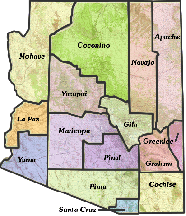
Click within the borders of any county in the map to jump to that county's resource list.
Countrywide
The table lists examples of suffix forms that are primary street suffix names, common street suffixes or suffix abbreviations, and recommended official Postal Service standard suffix abbreviations. See also Waze Standard Suffix Abbreviations
Statewide
This is the Arizona Department of Transportation APLAN ArcGIS Functional Classification map. This is the interactive map that all Arizona editors are to use when establishing FC implementation into the Waze Map Editor.
An interactive map showing Arizona's highways.
An interactive map showing all of Arizona's RailRoad network.
An interactive map showing the location of all the Arizona Highway mileposts.
An interactive map showing all of the Arizona Rest Stops location.
Useful for verifying current Gas Station statuses.
Counties
Apache County
Provides street names, and other information through various layers.
Cochise County
Cochise County Interactive Mapping Application. This will eventually replace the other ArcGIS maps for Cochise County
Provides street names, house number assignments, parcel ownership, names of natural features, names of city facilities, and names of educational, medical, and religious institutions.
Coconino County
Provides street names, house number assignments, parcel ownership, names of natural features, names of city facilities, and names of educational, medical, and religious institutions.
Provides street names, house number assignments, parcel ownership, names of natural features, names of city facilities, and names of educational, medical, and religious institutions.
Flagstaff does not freely provide direct access to its GIS interactive map. They do make a Street Map, and other maps available in PDF format.
Gila County
Provides Street names, and additional information through various layers. (Scroll down to find the link to the current map application.)
Graham County
Provides Street names, and additional information through various layers. (Scroll down to find the link to the current map application.)
Greenlee County
Provides street names.
La Paz County
Click on the GIS Mapping Website link in the lower right side of the page to access the current mapping application. Provides street names, property ownership, addresses, and other information through various layers.
Maricopa County
Live sortable database
Provides street names, house number assignments, and parcel ownership. Note that street names for private streets can be highly inaccurate, as can the directional designation (N, E, S, W) in some areas.
Links to several prepared maps in PDF format. None seem to provide street names or house numbers, but several contain information valuable for other mapping tasks.
Including links to a few PDF maps, plus their Map Anything map which provides street names and city boundaries.
- Chandler InfoMap
(requires Microsoft Silverlight plugin)
Provides street names, and house number assignments.
Non-interactive prepared maps in PDF format listed on the left side. Also, their 2009 Street Map Index is available in both large and small editions, which include street names but not house number assignments.
- Gilbert CIP Interactive Map
(requires Microsoft Silverlight plugin)
Provides street names, and house number assignments. Note that some minor streets might not be represented graphically, but with a sufficiently close zoom setting will be named.
Provides street names, and house number assignments.
Provides street names, construction information, street closures, and house number assignments. This is a more accurate resource for private street names within the City of Mesa.
- Phoenix
- Maps and Geographic Information Systems (GIS) Data
Provides street names, addresses and parcel information. (New mapping application for Phoenix as of 2015.) - 7th St and 7th Ave Reversible Lane Information
Information on the center reversible lanes that run on 7th Ave between McDowell and Northern, and on 7th St between McDowell and Dunlap. The project information is out of date (the noted projects are complete), but the information on restrictions and signage is current. - Planned Major Street Restrictions and Closures
Includes information about planned major street restrictions and closures associated with activities reported to the Street Transportation Department Right of Way Management Office.
- Maps and Geographic Information Systems (GIS) Data
Provides street names, and house number assignments.
Provides street names, and house number assignments.
- Tempe
- Street Closures & Restrictions
Lists current, upcoming and past street closures and restrictions for both construction projects and other events. Closures and restrictions for ASU sporting events are typically listed here. - Zoning Map
Provides street names, and house number assignments.
- Street Closures & Restrictions
Mohave County
Provides street names, property ownership, house number assignments, and other information through various layers.
Provides street names, property ownership, house number assignments, and other information through various layers.
Pima County
Provides a significant amount of information through various layers, including street names, house number assignments, property ownership, and the names of various types of institutions. Additional maps are available on the GIS Maps page, including several transportation maps.
Provides street names and house number assignments. Additional maps are available on the Map Resources page, and of particular interest to Waze map editors, on the TDOT Resource Center page.
Pinal County
Provides street names, and house number assignments.
PDF map of city street names in AJ.
Provides street names. Parcels link to the Pinal County Assessor's web site record for the property, which can be used to obtain house number assignments.
Non-interactive maps in PDF format. The City Street Map privides street names. Also included is the Coolidge Portion Proposed North-South Freeway map.
Provides street names, and and names of parks.
Provides street names, house number assignments, and other information.
- Queen Creek
See Queen Creek in Maricopa County.
Santa Cruz County
Access the Assessors map for street names and other information through various layers.
Yavapai County
Provides street names, and a significant amount of additional information by enabling various layers. For example, turn on the Address Labels under Property Features for house number assignments, or Topo Features under Land Features for the names of natural features, park names, city facilities, educational institution names, religious institution names, etc.
Chino Valley does not freely provide direct access to its GIS interactive map. They do make a Street Map, a Street Name List, and other maps available in PDF format. The Street Map provides street names.
Prescott Valley does not freely provide direct access to its GIS interactive map. They do make a Street Map, and other maps available in PDF format. The Street Map includes street names, and the names of parks, some city facilities, and educational institutions.
Yuma County
Provides street names, property ownership, house number assignments, and other information