m (→Road type) |
No edit summary |
||
| Line 1: | Line 1: | ||
Ferries are | {{merge global|Ferries/USA}} | ||
<!--if the section parameter is defined, do not place the visible banner, only as the code block for the top of a section-->{{GlobalMark/visible}} | |||
<!-- | |||
#####-----#####-----#####-----#####-----#####-----#####-----#####-----#####----- | |||
#### This page has been curated #### | |||
#### to be included in the new #### | |||
#### Wazeopedia - GLOBAL Wiki. #### | |||
#### Please do not make any #### | |||
#### edits on this page without #### | |||
#### PRIOR CONSENSUS in the Wiki #### | |||
#### Updates and Discussions #### | |||
#### forum thread for this page. #### | |||
#### If a specific forum thread #### | |||
#### for this page doesn't exist #### | |||
#### please start one. #### | |||
#### www.waze.com/forum/ #### | |||
#### viewforum.php?f=276 #### | |||
#####-----#####-----#####-----#####-----#####-----#####-----#####-----#####--> | |||
{{ReturnTo | Editing manual | the editing manual}} | |||
Ferries are large water crafts (boats) that carry vehicles (and people) from one ferry dock to another. Ferries normally have scheduled sailings and are often run as a part of the highway system. | |||
In some states, ferries are a key part of the roadway system and are hard to avoid. In some areas it is important to have them added to the map because they are sometimes the best option, and in a few cases the only option, to get to a destination. | In some states, ferries are a key part of the roadway system and are hard to avoid. In some areas it is important to have them added to the map because they are sometimes the best option, and in a few cases the only option, to get to a destination. | ||
| Line 12: | Line 35: | ||
*Ferries over two hours in duration | *Ferries over two hours in duration | ||
If the ferry does not meet any of the above conditions, it can be added to the map | If the ferry does not meet any of the above conditions, it can be added to the map. | ||
If you have any questions about whether the ferry should or should not be mapped, contact your [[Roles and responsibilities#Coordinators | Country Coordinator]] (or, in large countries, your [[Regional Coordinator]]) or post in the [http://www.waze.com/forum/viewforum.php?f=8 forum.] | |||
== How to add == | == How to add == | ||
The full length of the ferry route and both docking points must be part of your [[editable area]]. It may be necessary to ride the ferry with Waze running to add that route to your area. | |||
# | #Turn on the [[Map_Editor_Interface_and_Controls#GPS_points|GPS Points Layer]] to see the ferry's typical path. If no GPS point are visible, it may be OK to simply draw a straight line between the two docks. | ||
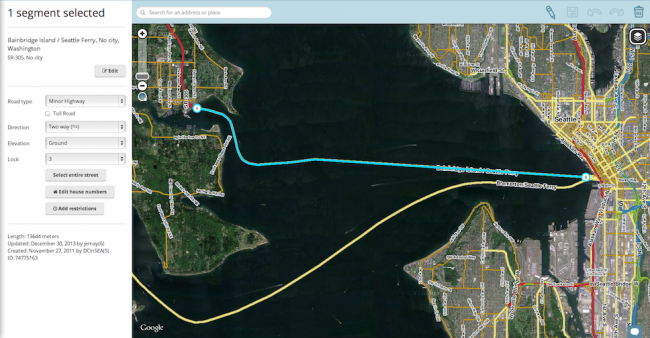
#[[Map_Editing_Quick-start_Guide#Create_a_Road|Draw a segment]] from one ferry dock to the other following the GPS points. [[Map_Editor_Interface_and_Controls#Segment_Edit_Detail|Name and label the new segment]] with '''No City''' and with the road name of the ferry line. This is often the combined names of both sides of the Ferry. For example: | #[[Map_Editing_Quick-start_Guide#Create_a_Road|Draw a segment]] from one ferry dock to the other following the GPS points. [[Map_Editor_Interface_and_Controls#Segment_Edit_Detail|Name and label the new segment]] with '''No City''' and with the road name of the ferry line. This is often the combined names of both sides of the Ferry. For example: Bainbridge Island - Seattle Ferry. The [[Road types and names|road type]] should match the road type on either side of ferry. Do not use Ferry, Freeway, Parking Lot, or Private Road Types. If the ferry is a part of the highway system, then it should be marked Minor or Major Highway. Be sure to set the [[Scheduled_restrictions|time restrictions]] on the segment including the first ferry (opening time) and the last ferry (closing time). [[File:Ferry_Segment.png|650px|left]] {{Clear}} | ||
#Draw segments on both loading ramps using the same road type as the ferry. These should have the correct city name entered on each side and "Ferry Loading Ramp" in road name field for both. (Editor Note: This gives some separation from the ferry and the ferry's slow waiting lines, enabling better routing.) | |||
#Draw a [[Creating_and_Editing_street_segments#Set_Road_Type.2C_Direction.2C_and_Elevation|one-way segment]] connecting the loading ramp segment to the main road on both sides using the same road type as the ferry. Label it with the correct city name on each side and '''No Name''' in name field. If ferry has multiple exit routes and clear signs then you can label the exit road with the standard "to: X" and "to: Y". Example "to: Seattle" and "to: I-90 / I-5". | |||
# | #Draw another one-way segment connecting the main roads to the loading ramp segment on both sides using the same road type as the ferry. Mark is as a '''toll road''' if it has a fee in the direction of this segment. It should be labeled with correct city name on each side and "to Bainbridge Island - Seattle Ferry". (Editor Note: some ferries charge riders going one direction and not the other. You commonly see this when ferries are going to an Island where the ferry is the only access, then the ferry going to the island is '''toll road''' and ferry going to main land is not tolled. Splitting exit and entrance ramps enable this flexibility). | ||
'''Examples of properly mapped ferry docks''' | |||
[[File:Bainbridge_Island.png|340px|left]][[File:Seattle_Dock.png|340px|right]] | |||
{{Clear}} | |||
''' | == Road types == | ||
[[ | |||
{{mbox | |||
| type = warning | |||
| text = The Ferry Road type is not to be used at this time. '''Do not use the Ferry Road type for any purpose.''' For more information [http://www.waze.com/forum/viewtopic.php?f=276&t=81265&view=unread#unread see this forum] for the latest information on this topic. | |||
}} | |||
{{clear}} | |||
== Future ferry support == | |||
As of Feb 2014, there is no set schedule when Waze will add further support for ferry routes, but it is in the list of future features. See the [[Talk:Ferries|talk page]] for more information. | |||
{{ReturnTo | Editing manual | the editing manual}} | |||
[[Category:Style Guides]] | |||
Revision as of 07:23, 14 August 2016
| This global page is flagged to be merged with the respective USA page. Ferries/USA |

Ferries are large water crafts (boats) that carry vehicles (and people) from one ferry dock to another. Ferries normally have scheduled sailings and are often run as a part of the highway system.
In some states, ferries are a key part of the roadway system and are hard to avoid. In some areas it is important to have them added to the map because they are sometimes the best option, and in a few cases the only option, to get to a destination.
Not all ferries should be mapped however. The following guidelines should be followed when considering adding a ferry onto the Waze map.
When and when not to add
Ferries that meet any of these conditions should generally not be mapped.
- Passenger ferries without vehicles
- Ferries requiring pre-booking
- Private ferries unavailable to the general public
- Ferries over two hours in duration
If the ferry does not meet any of the above conditions, it can be added to the map.
If you have any questions about whether the ferry should or should not be mapped, contact your Country Coordinator (or, in large countries, your Regional Coordinator) or post in the forum.
How to add
The full length of the ferry route and both docking points must be part of your editable area. It may be necessary to ride the ferry with Waze running to add that route to your area.
- Turn on the GPS Points Layer to see the ferry's typical path. If no GPS point are visible, it may be OK to simply draw a straight line between the two docks.
- Draw a segment from one ferry dock to the other following the GPS points. Name and label the new segment with No City and with the road name of the ferry line. This is often the combined names of both sides of the Ferry. For example: Bainbridge Island - Seattle Ferry. The road type should match the road type on either side of ferry. Do not use Ferry, Freeway, Parking Lot, or Private Road Types. If the ferry is a part of the highway system, then it should be marked Minor or Major Highway. Be sure to set the time restrictions on the segment including the first ferry (opening time) and the last ferry (closing time).
- Draw segments on both loading ramps using the same road type as the ferry. These should have the correct city name entered on each side and "Ferry Loading Ramp" in road name field for both. (Editor Note: This gives some separation from the ferry and the ferry's slow waiting lines, enabling better routing.)
- Draw a one-way segment connecting the loading ramp segment to the main road on both sides using the same road type as the ferry. Label it with the correct city name on each side and No Name in name field. If ferry has multiple exit routes and clear signs then you can label the exit road with the standard "to: X" and "to: Y". Example "to: Seattle" and "to: I-90 / I-5".
- Draw another one-way segment connecting the main roads to the loading ramp segment on both sides using the same road type as the ferry. Mark is as a toll road if it has a fee in the direction of this segment. It should be labeled with correct city name on each side and "to Bainbridge Island - Seattle Ferry". (Editor Note: some ferries charge riders going one direction and not the other. You commonly see this when ferries are going to an Island where the ferry is the only access, then the ferry going to the island is toll road and ferry going to main land is not tolled. Splitting exit and entrance ramps enable this flexibility).

Examples of properly mapped ferry docks


Road types
| The Ferry Road type is not to be used at this time. Do not use the Ferry Road type for any purpose. For more information see this forum for the latest information on this topic. |
Future ferry support
As of Feb 2014, there is no set schedule when Waze will add further support for ferry routes, but it is in the list of future features. See the talk page for more information.