(Nzahn1 uploaded a new version of "File:Jct Y ex map bad.png") |
No edit summary |
||
| Line 1: | Line 1: | ||
Y junction example, with less than optimal mapping | Y junction example, with less than optimal mapping | ||
[https://www.waze.com/editor/?env=usa&lon=-73.66356&lat=40.64098&layers=517&zoom=7&segments=33891473 PermaLink] | |||
Revision as of 03:07, 17 July 2015
Y junction example, with less than optimal mapping
File history
Click on a date/time to view the file as it appeared at that time.
| Date/Time | Thumbnail | Dimensions | User | Comment | |
|---|---|---|---|---|---|
| current | 02:59, 17 July 2015 | 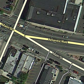 | 350 × 350 (247 KB) | Nzahn1 (talk | contribs) | new road layer colors |
| 02:20, 9 August 2012 | Error creating thumbnail: File missing | 200 × 199 (81 KB) | Weeezer14 (talk | contribs) | Y junction example, with less than optimal mapping |
File usage
The following file is a duplicate of this file (more details):
- File:Jct Y ex map bad.png from a shared repository
The following page uses this file: