m (→Editing) |
(→Roads: Groups) |
||
| Line 60: | Line 60: | ||
<li>Any road that acts, looks, & feels like a freeway should be set to Freeway road type</li> | <li>Any road that acts, looks, & feels like a freeway should be set to Freeway road type</li> | ||
<li>{{Lock Standard State|Northeast}}</li> | <li>{{Lock Standard State|Northeast}}</li> | ||
=Groups= | |||
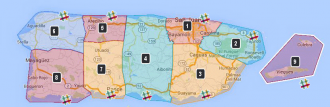
<imagemap>File:Mapraid_pr.png|thumb|330px|alt=Map of Puerto Rico with Mapraid areas shown|Click on your map raid group to edit in your area or "#Slack" logo to go to your slack channel. | |||
poly 420 46 418 76 416 70 435 103 436 109 496 108 502 88 538 83 551 57 524 53 517 62 491 47 491 47 475 46 [https://www.waze.com/editor/?env=usa&lon=-66.10973&lat=18.35242&zoom=0 group 1] | |||
poly 558 62 546 89 545 94 510 97 509 124 590 144 622 159 656 138 656 99 630 111 612 86 611 73 [https://www.waze.com/editor/?env=usa&lon=-65.80143&lat=18.27746&layers=1797&zoom=0 group 2] | |||
poly 440 118 481 120 506 142 604 166 576 213 538 238 523 217 498 221 500 253 432 263 [https://www.waze.com/editor/?env=usa&lon=-65.98759&lat=18.10193&layers=1797&zoom=0 group 3] | |||
poly 322 41 408 40 410 81 429 112 433 257 380 249 381 226 352 222 348 249 317 243 313 143 [https://www.waze.com/editor/?env=usa&lon=-66.39690&lat=18.22427&zoom=0 group 4] | |||
poly 208 40 262 40 274 59 299 55 297 39 304 41 308 101 265 99 216 98 222 83 [https://www.waze.com/editor/?env=usa&lon=-66.60084&lat=18.37644&layers=1797&zoom=0 group 5] | |||
poly 96 33 133 31 158 59 177 55 180 36 196 39 196 122 125 115 112 122 75 116 47 89 [https://www.waze.com/editor/?env=usa&lon=-67.02797&lat=18.36473&zoom=0 group 6] | |||
poly 213 108 251 113 300 106 300 169 308 256 295 251 289 223 262 217 262 253 228 247 231 226 212 217 [https://www.waze.com/editor/?env=usa&lon=-66.68019&lat=18.13094&layers=1797&zoom=0 group 7] | |||
poly 84 130 120 131 137 122 202 140 212 250 183 260 179 239 163 230 146 237 147 264 57 258 [https://www.waze.com/editor/?env=usa&lon=-67.09411&lat=18.13949&layers=1797&zoom=0 group 8] | |||
poly 652 180 738 80 793 88 823 116 793 194 669 217 [https://www.waze.com/editor/?env=usa&lon=-65.38920&lat=18.21009&layers=1797&zoom=0 group 9] | |||
poly 497 44 502 60 501 61 520 60 533 56 527 37 521 26 [https://wazemapraid.slack.com/messages/mr_puertorico-01 Slack group 1] | |||
poly 622 87 631 66 654 98 624 101 [https://wazemapraid.slack.com/messages/mr_puertorico-02 Slack group 2] | |||
poly 504 237 509 227 524 227 530 237 530 251 509 255 [https://wazemapraid.slack.com/messages/mr_puertorico-03 Slack group 3] | |||
poly 359 257 357 232 370 229 378 235 383 252 [https://wazemapraid.slack.com/messages/mr_puertorico-04 Slack group 4] | |||
poly 273 51 270 35 273 27 289 27 297 44 290 51 [https://wazemapraid.slack.com/messages/mr_puertorico-05 Slack group 5] | |||
poly 151 51 144 32 156 20 174 25 176 44 171 49 159 51 [https://wazemapraid.slack.com/messages/mr_puertorico-06 Slack group 6] | |||
poly 265 241 270 226 281 229 290 237 294 250 270 254 [https://wazemapraid.slack.com/messages/mr_puertorico-07 Slack group 7] | |||
poly 158 263 161 233 178 240 180 257 173 260 [https://wazemapraid.slack.com/messages/mr_puertorico-08 Slack group 8] | |||
poly 749 205 772 197 783 224 755 228 [https://wazemapraid.slack.com/messages/mr_puertorico-09 Slack group 9] | |||
#<!-- Created by Online Image Map Editor (http://www.maschek.hu/imagemap/index) --> | |||
</imagemap><div style="width: 340px"> | |||
<!-- put the team list here {{#widget:Iframe | |||
|url=https://docs.google.com/spreadsheets/d/1R1Z_UjXVKjUhraEw8wMCxRQvH_rDBpt0fTGn30FJt6Y/pubhtml?gid=1571469040&single=true | |||
|width=350 | |||
|border=0 | |||
|height=2100}}--> | |||
<!-- | |||
<div style="width:350px;height:1500px; border: solid black 2px;">Placeholder for group list</div>--> | |||
<br style="clear: all;" /></div> | |||
Revision as of 11:01, 14 August 2015
Welcome to the Puerto Rico MapRaid. I would like to first apologize there is no wiki for Puerto Rico, as there have been no real local editors. 2nd, I would also like to apologize for the lack of StreetView on the island. 3rd, I would like to apologize for the not so great SATIMG on the island, as well. 4th, I would like to apologize there is no good GIS map for PR, either.
Editing
Map Resources
- ArcGIS Viewer (requires Microsoft Silverlight)
- Connect Puerto Rico
- For additional GIS resources, as well as ESRI (if it's available).
Places
All places are to be drawn fence line to fence line, as is the standard for the United States
Places should primarily be in Spanish and an alternative name for places of importance such as local airports, universities and hospitals.
City/Town Naming
Places of Interest/Schools
* Not a thorough listing of historical sites. Additional sites may be found via National Register of Historic Places Program
Locking Standard
| PLACE TYPE | LOCK LEVEL |
|---|---|
| Hospitals / Urgent Care | 5 |
| Schools / Universities / Colleges | 5 |
| Military Installation / Airport | 4 |
| National & State Parks and Monuments | 4 |
| Police & Fire Dept | 3 |
| Gas Stations | 3 |
| Government Buildings / Consulates | 3 |
| City and Local Parks | 2 |
- All Places that have complete information (to include, at a minimum, address/city, phone number) are to be locked at Level 2. This is to prevent loss of data due to automatic acceptance of Place Update submissions from Trusted Users, or Place Update Request approvals from other editors without careful examination.
- If you do not have a high enough enough rank to lock the place as indicated, please lock it as high as you can, and notify a higher rank AM, SM, CM, or Champ to lock it higher.
Roads
| Segment Type | Statewide |
|---|---|
| Freeway | 5 |
| Ramp | Highest rank of connected segments |
| Major Highway | 3 |
| Minor Highway | 3 |
| Primary Street | 2 |
| Street | 1 (Auto) |
| Private Road | 1 (Auto) |
| • • • • Ferry • • • • | 5 |
| |-|-|-|-|-|-|-|-|-| Railroad |-|-|-|-|-|-|-|-|-| | 2 |
Note: Do Not Mass Edit just to update locks to these standards, these can be adjusted as you find them while editing other aspects of the segments such as FC, speed limits, naming, etc.
Some segments still warrant higher locks and care should be taken when setting segment lock to these standards to look for and protect these special setups with higher locks. Some examples; segments which are part of BDP, U-turn prevention, or using micro-doglegs, or other complex intersection setups.Groups