No edit summary |
|||
| (46 intermediate revisions by 4 users not shown) | |||
| Line 1: | Line 1: | ||
[[File:PuertoRico.png|500px|center]] | |||
Welcome to the Puerto Rico MapRaid! The MapRaid starts at '''Midnight''' 00:00 AST / 04:00 UTC, on August 16th and runs until August 22nd, 2015. | |||
=Map Resources= | |||
*[http://prddst.uprm.edu/apps/prtmp/ ArcGIS Viewer] ( | ==Editing== | ||
I would like to first apologize there is no wiki for Puerto Rico, as there have been no real local editors. 2nd, I would also like to apologize for the lack of StreetView on the island. 3rd, I would like to apologize for the not so great SATIMG on the island, as well. 4th, I would like to apologize there is no good GIS map for PR, either. | |||
* The primary languages of Puerto Rico are English and Spanish. Everything should be in '''Spanish''', unless noted otherwise. | |||
* Please use your best guess as to roads in the trees; turning on the GPS Points layer may help. | |||
==Map Resources== | |||
*[http://prddst.uprm.edu/apps/prtmp/ ArcGIS Viewer] (Requires Microsoft Silverlight. The non-Silverlight version is below.) | |||
*[http://www.connectpr.org/mapping/_interactive_map_interface/?q=map Connect Puerto Rico] | *[http://www.connectpr.org/mapping/_interactive_map_interface/?q=map Connect Puerto Rico] | ||
*For additional [http://www2.pr.gov/agencias/gis/Pages/default.aspx GIS resources], as well as ESRI (if it's available). | *For additional [http://www2.pr.gov/agencias/gis/Pages/default.aspx GIS resources], as well as ESRI (if it's available). | ||
=Places= | ==Places== | ||
All places are to be drawn fence line to fence line, as is the standard for the United States | All places are to be drawn fence line to fence line, as is the standard for the United States | ||
| Line 18: | Line 22: | ||
=== City/Town Naming === | === City/Town Naming === | ||
*[http:// | *[http://welcome.topuertorico.org/city/index.shtml The island's 87 municipalities] | ||
=== Places of Interest/Schools === | === Places of Interest/Schools === | ||
| Line 25: | Line 29: | ||
''* Not a thorough listing of historical sites. Additional sites may be found via [http://www.nps.gov/nr/research/ National Register of Historic Places Program]'' | ''* Not a thorough listing of historical sites. Additional sites may be found via [http://www.nps.gov/nr/research/ National Register of Historic Places Program]'' | ||
=== Place Browser Tool === | |||
As with previous MapRaids, a [https://w-tools.org/PlaceBrowser?group=MapRaidPuertoRico Place Browser] has been created. This is an invaluable tool for working on existing places. Be sure to click the About tab to get an overview of the tool. Credit is due to [https://www.waze.com/forum/memberlist.php?mode=viewprofile&u=9163787 Joyriding] | |||
=== Locking Standard === | === Locking Standard === | ||
| Line 37: | Line 45: | ||
|- | |- | ||
| Military Installation / Airport || 4 | | Military Installation / Airport || 4 | ||
|- | |-" | ||
| National & State Parks and Monuments || 4 | | National & State Parks and Monuments || 4 | ||
|- | |- | ||
| Line 54: | Line 62: | ||
:If you do not have a high enough enough rank to lock the place as indicated, please lock it as high as you can, and notify a higher rank [[#Area Managers|AM, SM, CM, or Champ]] to lock it higher. | :If you do not have a high enough enough rank to lock the place as indicated, please lock it as high as you can, and notify a higher rank [[#Area Managers|AM, SM, CM, or Champ]] to lock it higher. | ||
=Roads= | ==Roads== | ||
* There currently is no FC for PR. | |||
* All freeways are set to ground level. If two freeways cross each other, look at the actual intersection to discover the layers of the intersection | |||
* Road names should follow the PR-### format and a general rule of thumb is: | |||
:* PR-1 through PR-99 & PR-165 are Major Highways (those with Blue Shields are Freeways) | |||
=Groups= | :* PR-100 through PR-206, PR-250 & PR-251 are Minor Highways | ||
<imagemap>File:Mapraid_pr.png|thumb|left|700px|alt=Map of Puerto Rico with Mapraid areas shown|Click on your map raid group to edit in your area or "#Slack | :* PR-300 through PR-9914 are Primary Streets | ||
*When adding cardinal directions to street maps use the Spanish letter surrounded by parentheses | |||
:* (N) = Norte = North | |||
:* (S) = Sur = South | |||
:* (E) = Este = East | |||
:* (O) = Oeste = West | |||
*Calle and Avenida should be spelled out for proper TTS pronunciation. | |||
{{Lock Standard State|Northeast}} | |||
== Update Requests == | |||
Update Requests (URs) wait time will be 5 days. | |||
== Reference Links == | |||
=== The Basics === | |||
*[[Waze Map Editor/Welcome|New editor welcome page]] | |||
*[[Waze Map Editor]] | |||
*[[Best Map Editing Practice]] | |||
*[[Editing manual]] | |||
*[[Common editing mistakes]] | |||
*[[Permalink|How to make a Permalink]] | |||
*[[WME Chat|All about using the WME Chat]] | |||
*[[Community Plugins, Extensions and Tools]] where you'll links and descriptions to most of the editing scripts being used. Some of these are essential to good editing, and others make the editing process much easier. WME Validator, URO+, and WME Toolbox are highly recommended. | |||
=== Recommended Tools for MapRaid === | |||
* [//greasyfork.org/en/scripts/11702-wme-mapraid-puerto-rico-overlay MapRaid Overlay] tampermonkey/greasemonkey required | |||
* [http://bit.ly/overlay_PR_counties Puerto Rico County/District Overlay] tampermonkey/greasemonkey required | |||
* [http://w-tools.org/PlaceBrowser?group=MapRaidPuertoRico MapRaid Place Browser] | |||
* [//wiki.waze.com/wiki/User:Rickzabel/UrComments/ UR Comments] - a tremendous time and labor saving tool with automation and integration with URO+, to help with working URs. Read the documentation. Tampermonkey / greasemonkey required | |||
* The [http://drive.google.com/file/d/0B8WbeRGWGEOjQ1BvbHFtYlJSV2pIOVdyQlgtRmJzQUtHNjRz WME Reference Sheet<sup><small><nowiki>[PDF]</nowiki></small></sup>] is a printable double-sided tri-fold quick reference guide to some of the common topics used in WME. | |||
* [http://www.waze.com/forum/viewtopic.php?t=76488 Validator] is a script that validates a map area in Waze Map Editor, highlights issues and generates a very detailed report with wiki references and solutions. | |||
** Chrome browser: please download the script at [http://chrome.google.com/webstore/detail/wme-validator/baojhpeknpmkhplkcnpdcficcaaniaih Chrome Web Store] | |||
** Firefox browser: please download the script at [http://greasyfork.org/scripts/1571-wme-validator GreasyFork.org] -- tampermonkey or greasemonkey required | |||
* [http://greasyfork.org/en/scripts/2103-wme-chat-addon WME Chat Addon] is a script that improves the WME chat GUI. For a list of all the features check the thread [http://www.waze.com/forum/viewtopic.php?f=819&t=95038 here] -- Tapermonkey/Greasmonkey required | |||
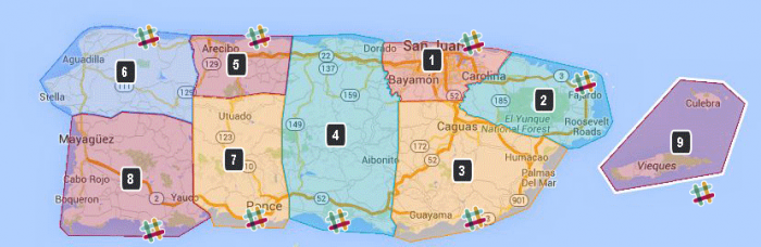
==Groups== | |||
<imagemap>File:Mapraid_pr.png|thumb|left|700px|alt=Map of Puerto Rico with Mapraid areas shown|Click on your map raid group to edit in your area or "#" Slack logo to go to your slack channel. | |||
poly 420 46 418 76 416 70 435 103 436 109 496 108 502 88 538 83 551 57 524 53 517 62 491 47 491 47 475 46 [https://www.waze.com/editor/?env=usa&lon=-66.10973&lat=18.35242&zoom=0 group 1] | poly 420 46 418 76 416 70 435 103 436 109 496 108 502 88 538 83 551 57 524 53 517 62 491 47 491 47 475 46 [https://www.waze.com/editor/?env=usa&lon=-66.10973&lat=18.35242&zoom=0 group 1] | ||
poly 558 62 546 89 545 94 510 97 509 124 590 144 622 159 656 138 656 99 630 111 612 86 611 73 [https://www.waze.com/editor/?env=usa&lon=-65.80143&lat=18.27746&layers=1797&zoom=0 group 2] | poly 558 62 546 89 545 94 510 97 509 124 590 144 622 159 656 138 656 99 630 111 612 86 611 73 [https://www.waze.com/editor/?env=usa&lon=-65.80143&lat=18.27746&layers=1797&zoom=0 group 2] | ||
| Line 89: | Line 135: | ||
|height=2100}} | |height=2100}} | ||
--> | --> | ||
To find your group, please [https://www.waze.com/forum/viewtopic.php?f=1392&t=154474 login and check the forums] | |||
[[Category:Mapraid]] | |||
Latest revision as of 13:45, 9 September 2015

Welcome to the Puerto Rico MapRaid! The MapRaid starts at Midnight 00:00 AST / 04:00 UTC, on August 16th and runs until August 22nd, 2015.
Editing
I would like to first apologize there is no wiki for Puerto Rico, as there have been no real local editors. 2nd, I would also like to apologize for the lack of StreetView on the island. 3rd, I would like to apologize for the not so great SATIMG on the island, as well. 4th, I would like to apologize there is no good GIS map for PR, either.
- The primary languages of Puerto Rico are English and Spanish. Everything should be in Spanish, unless noted otherwise.
- Please use your best guess as to roads in the trees; turning on the GPS Points layer may help.
Map Resources
- ArcGIS Viewer (Requires Microsoft Silverlight. The non-Silverlight version is below.)
- Connect Puerto Rico
- For additional GIS resources, as well as ESRI (if it's available).
Places
All places are to be drawn fence line to fence line, as is the standard for the United States
Places should primarily be in Spanish and an alternative name for places of importance such as local airports, universities and hospitals.
City/Town Naming
Places of Interest/Schools
* Not a thorough listing of historical sites. Additional sites may be found via National Register of Historic Places Program
Place Browser Tool
As with previous MapRaids, a Place Browser has been created. This is an invaluable tool for working on existing places. Be sure to click the About tab to get an overview of the tool. Credit is due to Joyriding
Locking Standard
| PLACE TYPE | LOCK LEVEL |
|---|---|
| Hospitals / Urgent Care | 5 |
| Schools / Universities / Colleges | 5 |
| Military Installation / Airport | 4 |
| National & State Parks and Monuments | 4 |
| Police & Fire Dept | 3 |
| Gas Stations | 3 |
| Government Buildings / Consulates | 3 |
| City and Local Parks | 2 |
- All Places that have complete information (to include, at a minimum, address/city, phone number) are to be locked at Level 2. This is to prevent loss of data due to automatic acceptance of Place Update submissions from Trusted Users, or Place Update Request approvals from other editors without careful examination.
- If you do not have a high enough enough rank to lock the place as indicated, please lock it as high as you can, and notify a higher rank AM, SM, CM, or Champ to lock it higher.
Roads
- There currently is no FC for PR.
- All freeways are set to ground level. If two freeways cross each other, look at the actual intersection to discover the layers of the intersection
- Road names should follow the PR-### format and a general rule of thumb is:
- PR-1 through PR-99 & PR-165 are Major Highways (those with Blue Shields are Freeways)
- PR-100 through PR-206, PR-250 & PR-251 are Minor Highways
- PR-300 through PR-9914 are Primary Streets
- When adding cardinal directions to street maps use the Spanish letter surrounded by parentheses
- (N) = Norte = North
- (S) = Sur = South
- (E) = Este = East
- (O) = Oeste = West
- Calle and Avenida should be spelled out for proper TTS pronunciation.
In Puerto Rico MapRaid we have a set minimum standard for locking roads based on segment type. Any road of a certain segment type must be locked at least to the rank (level) in the chart below. Roads may be locked higher for protection and special situations (areas with construction, tricky design, frequent mistakes, imaging inaccuracies, and the like), but should not be locked lower.
A great time to implement these locks is while bringing the road types of an area into compliance with the current US road type standards (FC and highway systems). Lock the roads based on type after they've been set to current US road type standards.
| Segment Type | Statewide |
|---|---|
| Freeway | 5 |
| Ramp | Highest rank of connected segments |
| Major Highway | 3 |
| Minor Highway | 3 |
| Primary Street | 2 |
| Street | 1 (Auto) |
| Private Road | 1 (Auto) |
| • • • • Ferry • • • • | 5 |
| |-|-|-|-|-|-|-|-|-| Railroad |-|-|-|-|-|-|-|-|-| | 2 |
Note: Do Not Mass Edit just to update locks to these standards, these can be adjusted as you find them while editing other aspects of the segments such as FC, speed limits, naming, etc.
Some segments still warrant higher locks and care should be taken when setting segment lock to these standards to look for and protect these special setups with higher locks. Some examples; segments which are part of BDP, U-turn prevention, or using micro-doglegs, or other complex intersection setups.
Update Requests
Update Requests (URs) wait time will be 5 days.
Reference Links
The Basics
- New editor welcome page
- Waze Map Editor
- Best Map Editing Practice
- Editing manual
- Common editing mistakes
- How to make a Permalink
- All about using the WME Chat
- Community Plugins, Extensions and Tools where you'll links and descriptions to most of the editing scripts being used. Some of these are essential to good editing, and others make the editing process much easier. WME Validator, URO+, and WME Toolbox are highly recommended.
Recommended Tools for MapRaid
- MapRaid Overlay tampermonkey/greasemonkey required
- Puerto Rico County/District Overlay tampermonkey/greasemonkey required
- MapRaid Place Browser
- UR Comments - a tremendous time and labor saving tool with automation and integration with URO+, to help with working URs. Read the documentation. Tampermonkey / greasemonkey required
- The WME Reference Sheet[PDF] is a printable double-sided tri-fold quick reference guide to some of the common topics used in WME.
- Validator is a script that validates a map area in Waze Map Editor, highlights issues and generates a very detailed report with wiki references and solutions.
- Chrome browser: please download the script at Chrome Web Store
- Firefox browser: please download the script at GreasyFork.org -- tampermonkey or greasemonkey required
- WME Chat Addon is a script that improves the WME chat GUI. For a list of all the features check the thread here -- Tapermonkey/Greasmonkey required
Groups
To find your group, please login and check the forums