When you are editing in the raid area, please [[Waze_Map_Editor/Chat#Visible.2FInvisible|set yourself visible]] and enable the [[Map_Editor_Interface_and_Controls#Live_Users|Live Users]] layer.
When you are editing in the raid area, please [[Waze_Map_Editor/Chat#Visible.2FInvisible|set yourself visible]] and enable the [[Map_Editor_Interface_and_Controls#Live_Users|Live Users]] layer.
We will use ''#''Slack Channels. There is a [http://wazemapraid.slack.com/messages/
We will use ''#''Slack Channels. There is a [https://wazemapraid.slack.com/messages/mr_ri/ Raid general channel] and also a channel for each raid group. {{U|Please be sure to join the slack WazeMapRaid Team and join the channels for the specific MapRaid and group you are assigned to.}} If you are not already part of the WazeMapRaid slack team, '''Click here to get your [http://bit.ly/GetWazeSlackInvite Slack invitation]. Be sure to choose {{u|WazeMapRaid}} to the MapRaid question.''' If you have trouble getting into the slack team and channels, please reach out to one of the MapRaid organizers.
xxx
yyy Raid general channel] and also a channel for each raid group. {{U|Please be sure to join the slack WazeMapRaid Team and join the channels for the specific MapRaid and group you are assigned to.}} If you are not already part of the WazeMapRaid slack team, '''Click here to get your [http://bit.ly/GetWazeSlackInvite Slack invitation]. Be sure to choose {{u|WazeMapRaid}} to the MapRaid question.''' If you have trouble getting into the slack team and channels, please reach out to one of the MapRaid organizers.
WME chat can also be used. The [http://www.waze.com/forum/viewtopic.php?f=819&t=95038 WME Chat addon] is recommended.
WME chat can also be used. The [http://www.waze.com/forum/viewtopic.php?f=819&t=95038 WME Chat addon] is recommended.
Line 60:
Line 58:
<div style="float:right;">
<div style="float:right;">
<imagemap>Image:Mapraid-ri-map.jpg|thumb|350px|alt=Map of Rhode Island with Mapraid areas shown
<imagemap>Image:Mapraid-ri-map.jpg|thumb|350px|alt=Map of Rhode Island with Mapraid areas shown
#<!-- Created by Online Image Map Editor (http://www.maschek.hu/imagemap/index) -->
#<!-- Created by Online Image Map Editor (http://www.maschek.hu/imagemap/index) -->
</imagemap>
</imagemap>
Line 111:
Line 109:
===Functional Classification===
===Functional Classification===
RI recently updated their [http://www.planning.ri.gov/statewideplanning/transportation/reclass.php Functional Classification maps], so we'll need to verify all the existing roads. For more information on Functional Classification, consult [[Road_types/USA#Quick_reference_chart|this chart]].
RI recently updated their [//www.planning.ri.gov/statewideplanning/transportation/reclass.php Functional Classification maps], so we'll need to verify all the existing roads. For more information on Functional Classification, consult [[Road types#Quick_reference_chart|this chart]].
'''NOTE''': If you're using the [//greasyfork.org/en/scripts/5010-wme-fc-color-highlights FC Highlights] script, here are the color codes for the RI FC maps:
We have recently adopted new naming rules for RI state highways, which should all be using the '''RI-XXX''' designation. Further information about RI's naming rules can be found in the [[Rhode_Island#Route_Naming|Route Naming]] section of the RI Wiki.
We have recently adopted new naming rules for RI state highways, which should all be using the '''RI-XXX''' designation. Further information about RI's naming rules, including when the RI-XXX designation should be a primary or alternate name, can be found in the [[Rhode_Island#Route_Naming|Route Naming]] section of the RI Wiki.
For this task, you'll need [[User:TheLastTaterTot|TheLastTaterTot]]'s [//greasyfork.org/en/scripts/13552-wme-rhode-island-urban-area-overlay RI Urban Area Overlay] script, which will designate which parts of the state are considered "urban".
For this task, you'll need [[User:TheLastTaterTot|TheLastTaterTot]]'s [//greasyfork.org/en/scripts/13552-wme-rhode-island-urban-area-overlay RI Urban Area Overlay] script, which will show where the urban areas of the state are (where RI-XXX should be alternate).
===Villages===
===Villages===
One distinct feature of RI is the concept of Villages, unincorporated named areas within legal municipalities. These areas need to be added to the map to improve address lookups and for display on the city layer. This means that some segments will require two different city names. Please be sure to read the RI Wiki's page on [[Rhode_Island/Cities_and_towns|Cities and Towns]] to get all the details.
One distinct feature of RI is the concept of Villages, unincorporated named areas within legal municipalities. These areas need to be added to the map to improve address lookups and for display on the Cities layer. There are also a couple city names that are invalid and need to be replaced, such as "Greater Westerly Area". Please be sure to read the RI Wiki's page on [[Rhode_Island/Cities_and_towns|Cities and Towns]] to get all the details.
Please use [[User:TheLastTaterTot|TheLastTaterTot]]'s [//greasyfork.org/en/scripts/13549-wme-rhode-island-cities-overlay RI Cities Overlay] script for this task, as it will display the borders for all villages in the state in WME.
Also, we'll need to use [[User:TheLastTaterTot|TheLastTaterTot]]'s [//greasyfork.org/en/scripts/13549-wme-rhode-island-cities-overlay RI Cities Overlay] script for this task, as it will display the borders for all cities and villages in the state in WME.
===Speed Limits===
===Speed Limits===
With the advent of Waze 4.0, speed limits are here, and we need to get them on all major roads in the state! For this effort, we'll need to add speed limit information to all roads PS and above. If you're feeling really ambitious, you can also add speed limits to Streets as well, just keep in mind that a lot of rural roads may not have speed limits posted at all. Be sure to consult Street View to determine the exact location of speed limit changes.
With the advent of Waze 4.0, speed limits are here, and we need to get them on all major roads in the state! For this effort, we'll need to add speed limit information to all roads PS and above. If you're feeling really ambitious, you can also add speed limits to Streets as well, just keep in mind that a lot of rural roads may not have speed limits posted at all. Be sure to consult Street View to determine the exact location of speed limit changes.
For more information about street limit standards, check out the [[Speed_limits/USA|Speed Limit guidelines]] in the Waze wiki.
'''NOTE:''' In RI, if there is no speed limit signs on a given road, the default speed limit is assumed to be '''25mph'''.
For more information about street limit standards, check out the [[Speed limits|Speed Limit guidelines]] in the Waze wiki.
===Elevations===
===Elevations===
Line 135:
Line 155:
* For every other case the road is ground level (level = Ground), even if it’s artificially elevated or dug under street level.
* For every other case the road is ground level (level = Ground), even if it’s artificially elevated or dug under street level.
*[[File:Tight_Marking.jpeg|thumbnail|right|Tight Marking]] '''Tight Marking'''. We mark bridges with level = +1. In some cases we will need to split segments into two or more segments to mark only the right parts of the road as a bridge or a tunnel. This is Tight Marking.
*[[File:Tight_Marking.jpeg|thumbnail|right|Tight Marking]] '''Tight Marking'''. We mark bridges with level = +1. In some cases we will need to split segments into two or more segments to mark only the right parts of the road as a bridge or a tunnel. This is Tight Marking.
** At interchanges, where there is already a nearby junction, it will often not be necessary to use "tight" marking for an elevation change on the overpass. Use the existing junctions if at all reasonable. Again, '''don't add an extra node for elevation if there's already an interchange node nearby'''
** At interchanges, where there is already a nearby junction (within 100m), it will often not be necessary to use "tight" marking for an elevation change on the overpass. Use the existing junctions if at all reasonable. Again, '''don't add an extra node for elevation if there's already an interchange node within 100m of the bridge.'''
** When adding tightly-marked bridges, make sure the resulting segment is longer than '''15m''' to avoid routing errors.
Also note that there are '''no tunnels''' in RI, so there should be no segments with a negative elevation or with the Tunnel box checked.
Also note that there are '''no tunnels''' in RI, so there should be no segments with a negative elevation or with the Tunnel box checked.
Line 144:
Line 165:
Another big effort that will need to take place is validating Places in RI. This includes verifying all data and photos are correct, as well as standardizing place names and locking at appropriate levels. Read up on the [[Places|Places wiki page]] for more information.
Another big effort that will need to take place is validating Places in RI. This includes verifying all data and photos are correct, as well as standardizing place names and locking at appropriate levels. Read up on the [[Places|Places wiki page]] for more information.
For this task, we'll be using [[User:Joyriding|Joyriding]]'s [//w-tools.org/PlaceBrowser?group=MapRaidRhodeIsland Place Browser] tool, which lists all the various Place issues in RI, and [[User:btmg|btmg]]'s [//greasyfork.org/en/scripts/13567-place-harmonizer Place Harmonizer] script, which will help standardize information for various businesses and organizations.
For this task, we'll be using [[User:Joyriding|Joyriding]]'s [//w-tools.org/PlaceBrowser?group=MapRaidRhodeIsland Place Browser] tool, which lists all the various Place issues in RI, and the [//greasyfork.org/en/scripts/13567-place-harmonizer Place Harmonizer] script, which will help standardize information for various businesses and organizations.
==Important / Mapraid guidelines==
==Important / Mapraid guidelines==
Line 165:
Line 185:
Generally speaking, you are responsible for every edit you make, whether you make it by hand or use a script. Every edit you make should meet the goals of this mapraid AND make a noticeable improvement to the map. If a segment is "good enough" for the waze map, do not edit it. If you edit segments previously edited by others, your name will be on these segments. This makes you responsible for any problems left on those segments, no matter who put them there originally.
Generally speaking, you are responsible for every edit you make, whether you make it by hand or use a script. Every edit you make should meet the goals of this mapraid AND make a noticeable improvement to the map. If a segment is "good enough" for the waze map, do not edit it. If you edit segments previously edited by others, your name will be on these segments. This makes you responsible for any problems left on those segments, no matter who put them there originally.
Unlike most MapRaids, we will not be keeping track of your number of edits or points, so don't bother rushing out there and touching every segment you come across. If it looks like you are making unnecessary edits or hunting for points, you may be '''banned from this MapRaid and from future MapRaids'''. In addition, '''Waze will throttle your edits and points if you use scripts excessively'''.
Unlike most MapRaids, '''we will not be keeping track of your number of edits or points''', so don't bother rushing out there and touching every segment you come across. If it looks like you are making unnecessary edits or hunting for points, you may be banned from this MapRaid and from future MapRaids. In addition, Waze will throttle your edits and points if you use scripts excessively.
===Road Locks===
===Road Locks===
Line 220:
Line 240:
-->
-->
* [//greasyfork.org/en/scripts/13552-wme-rhode-island-urban-area-overlay RI Urban Area Overlay]
* [//greasyfork.org/en/scripts/13552-wme-rhode-island-urban-area-overlay RI Urban Area Overlay]
* [//greasyfork.org/en/scripts/5010-wme-fc-color-highlights FC Highlights]
* [//greasyfork.org/en/scripts/13549-wme-rhode-island-cities-overlay RI Cities Overlay]
* [//greasyfork.org/en/scripts/13549-wme-rhode-island-cities-overlay RI Cities Overlay]
* [//greasyfork.org/en/scripts/13567-place-harmonizer Place Harmonizer]
:Greasemonkey/Tampermonkey are required for the above scripts
:Greasemonkey/Tampermonkey are required for the above scripts
* [//w-tools.org/PlaceBrowser?group=MapRaidRhodeIsland Map Raid Place Browser]
* [//w-tools.org/PlaceBrowser?group=MapRaidRhodeIsland Map Raid Place Browser]
* [//greasyfork.org/en/scripts/13567-place-harmonizer Place Harmonizer]
Rhode Island MapRaid 2016 ended on 16 Mar 2016 23:59:00 UTC. Please check back here for results and check the Mapraid Forum for mapraid announcements.
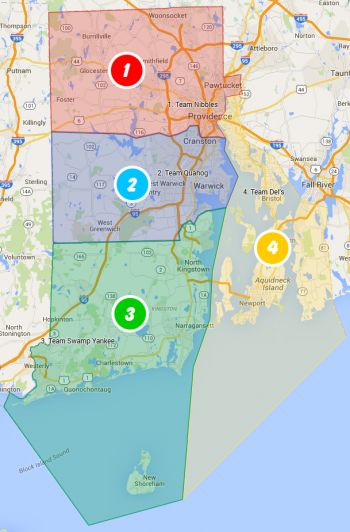
Welcome to the Rhode Island MapRaid, the biggest little raid in the country! This raid runs from March 7th through the 16th. The participants will be divided into several groups, one for each section of the map. Each group will have both local and senior editors, one of which will be the "Group leader" - listed in blue below. Please direct all questions to your group leaders. The raid hosts will be available across all areas for added support.
Mission
Our objective will be to take care of several tasks that require modifying many segments in bulk. These tasks include:
We will use #Slack Channels. There is a Raid general channel and also a channel for each raid group. Please be sure to join the slack WazeMapRaid Team and join the channels for the specific MapRaid and group you are assigned to. If you are not already part of the WazeMapRaid slack team, Click here to get your Slack invitation. Be sure to choose WazeMapRaid to the MapRaid question. If you have trouble getting into the slack team and channels, please reach out to one of the MapRaid organizers.
WME chat can also be used. The WME Chat addon is recommended.
There will also be a Google Hangout available to communicate with team leaders and other editors. To join, please send an email to waze@gkstudios.net with your Gmail address, and we'll send you an invite.
Highlighted names represent the team leaders of each group. If you have any questions or need any help during the Raid, check with your team leader first!
Tasks
Here are the different tasks that we'll be tackling in this MapRaid:
Functional Classification
RI recently updated their Functional Classification maps, so we'll need to verify all the existing roads. For more information on Functional Classification, consult this chart.
NOTE: If you're using the FC Highlights script, here are the color codes for the RI FC maps:
Color
Meaning
#E80060
Other Freeways
#E94117
Principal Arterial
#A34520
Minor Arterial
#C99126
Major Collector
State Route Naming
We have recently adopted new naming rules for RI state highways, which should all be using the RI-XXX designation. Further information about RI's naming rules, including when the RI-XXX designation should be a primary or alternate name, can be found in the Route Naming section of the RI Wiki.
For this task, you'll need TheLastTaterTot's RI Urban Area Overlay script, which will show where the urban areas of the state are (where RI-XXX should be alternate).
Villages
One distinct feature of RI is the concept of Villages, unincorporated named areas within legal municipalities. These areas need to be added to the map to improve address lookups and for display on the Cities layer. There are also a couple city names that are invalid and need to be replaced, such as "Greater Westerly Area". Please be sure to read the RI Wiki's page on Cities and Towns to get all the details.
Also, we'll need to use TheLastTaterTot's RI Cities Overlay script for this task, as it will display the borders for all cities and villages in the state in WME.
Speed Limits
With the advent of Waze 4.0, speed limits are here, and we need to get them on all major roads in the state! For this effort, we'll need to add speed limit information to all roads PS and above. If you're feeling really ambitious, you can also add speed limits to Streets as well, just keep in mind that a lot of rural roads may not have speed limits posted at all. Be sure to consult Street View to determine the exact location of speed limit changes.
NOTE: In RI, if there is no speed limit signs on a given road, the default speed limit is assumed to be 25mph.
For more information about street limit standards, check out the Speed Limit guidelines in the Waze wiki.
Elevations
We're hoping to get ahead of the game and standardize elevations throughout the state before the rumored 3D map makes its way to the Waze app. To that end, we'll be adopting the "seagull" rule for elevations: If a seagull can fly under it, then it needs an elevation above Ground, otherwise it stays at Ground level. Here's how that breaks down:
If a seagull can fly right under it, it’s a bridge (level greater than 0).
A road is only level = +2 if there’s another bridge (+1) running underneath it.
For every other case the road is ground level (level = Ground), even if it’s artificially elevated or dug under street level.
Tight MarkingTight Marking. We mark bridges with level = +1. In some cases we will need to split segments into two or more segments to mark only the right parts of the road as a bridge or a tunnel. This is Tight Marking.
At interchanges, where there is already a nearby junction (within 100m), it will often not be necessary to use "tight" marking for an elevation change on the overpass. Use the existing junctions if at all reasonable. Again, don't add an extra node for elevation if there's already an interchange node within 100m of the bridge.
When adding tightly-marked bridges, make sure the resulting segment is longer than 15m to avoid routing errors.
Also note that there are no tunnels in RI, so there should be no segments with a negative elevation or with the Tunnel box checked.
Another big effort that will need to take place is validating Places in RI. This includes verifying all data and photos are correct, as well as standardizing place names and locking at appropriate levels. Read up on the Places wiki page for more information.
For this task, we'll be using Joyriding's Place Browser tool, which lists all the various Place issues in RI, and the Place Harmonizer script, which will help standardize information for various businesses and organizations.
Important / Mapraid guidelines
Please read the entire MapRaid wiki. If you are still uncertain what to do about something you see on the map, please ask your group leader Thank You for your help with the map.
Update Requests (URs)
Since URs are not a focus of this MapRaid, please do not respond to any URs you may find during the Raid. Instead, please save any unanswered URs for L1 editors and their mentors to use as practice.
Edit Quality and Mass Editing
Generally speaking, you are responsible for every edit you make, whether you make it by hand or use a script. Every edit you make should meet the goals of this mapraid AND make a noticeable improvement to the map. If a segment is "good enough" for the waze map, do not edit it. If you edit segments previously edited by others, your name will be on these segments. This makes you responsible for any problems left on those segments, no matter who put them there originally.
Unlike most MapRaids, we will not be keeping track of your number of edits or points, so don't bother rushing out there and touching every segment you come across. If it looks like you are making unnecessary edits or hunting for points, you may be banned from this MapRaid and from future MapRaids. In addition, Waze will throttle your edits and points if you use scripts excessively.
Road Locks
In Rhode Island we have a set minimum standard for locking roads based on segment type. Any road of a certain segment type must be locked at least to the rank (level) in the chart below. Roads may be locked higher for protection and special situations (areas with construction, tricky design, frequent mistakes, imaging inaccuracies, and the like), but should not be locked lower.
A great time to implement these locks is while bringing the road types of an area into compliance with the current US road type standards (FC and highway systems). Lock the roads based on type after they've been set to current US road type standards.
Rhode Island Minimum Locking Rank Standard
Segment Type
Statewide
Freeway
5
Ramp
Highest rank of connected segments
Major Highway
4
Minor Highway
3
Primary Street
1 (Auto)
Street
1 (Auto)
Private Road
1 (Auto)
• • • • Ferry • • • •
5
|-|-|-|-|-|-|-|-|-| Railroad |-|-|-|-|-|-|-|-|-|
2
Note: Do Not Mass Edit just to update locks to these standards, these can be adjusted as you find them while editing other aspects of the segments such as FC, speed limits, naming, etc.
Some segments still warrant higher locks and care should be taken when setting segment lock to these standards to look for and protect these special setups with higher locks. Some examples; segments which are part of BDP, U-turn prevention, or using micro-doglegs, or other complex intersection setups.
Mapping Resources
Only use sources that are allowed by Waze, like Streetview from within WME. Do not use Google Maps. Do not use Google Maps Streetview. Websites from businesses are considered allowed sources.
Warning: If you copy information from unauthorized sources, you may be removed from this MapRaid. Also, every segment or place you edited might be removed from the map. Copying information from copyrighted sources is illegal!
Community Plugins, Extensions and Tools where you'll links and descriptions to most of the editing scripts being used. Some of these are essential to good editing, and others make the editing process much easier. WME Validator, URO+, and WME Toolbox are highly recommended.
This is a script that facilitate the process of editing maps in the WME. It has a toolbar that facilitates the process of removing unnecessary nodes, cut segments, locate "Soft Nodes", or nodes with undefined directions.
a tremendous time and labor saving tool with automation and integration with URO+, to help with working URs. Read the documentation. Tampermonkey / greasemonkey required
a printable double-sided tri-fold quick reference guide to some of the common topics used in WME.
Results
Check back here after the raid is completed to see the results and achievements
MapRaid Promotions
Some editors really let their bright side out, and let their community skills shine. This is even more evident in a concerted group effort with high-density editing like a MapRaid!. Editors of all ranks working closely with each other and the Champs, really lets us everyone get to know each other, and allows certain editors to be recognized for their skills and effort.
When the Champs see someone consistently editing well, interacting well with the community, and knowledgeable of the various details from the Wiki, they can issue promotions. This can be anything from the size of a managed area, to a rank increase, or even a new role.
Watch here for results of promotions during and after the raid.