Crazycaveman (talk | contribs) (Created page with "{{mbox|image=40px |text='''MapRaid! South Carolina''' {{#ifexpr:{{#time:xNU|2015-06-21T0000}}>{{#time:xNU|}}<!-- check if raid started yet--> |will begin on...") |
Kentsmith9 (talk | contribs) m (Fixed link) |
||
| (117 intermediate revisions by 8 users not shown) | |||
| Line 1: | Line 1: | ||
{{mbox| | {{mbox|type=warning|text= | ||
|text= | {{#ifexpr:{{#time:xNU|2015-06-15T0500}}>{{#time:xNU|}}|'''Registration is now open for MapRaid! South Carolina. If you would like to participate please fill out [https://docs.google.com/forms/d/18w8bxr4HPki22yGDLzHnrlRswLOoes3RlfOTkSOWHio/viewform this form] before 2015-06-20 05:00 UTC.'''|Registration for the MapRaid! is now closed. To hear about future MapRaids please join the [http://wazemapraid.slack.com MapRaid ''#''Slack].}} | ||
{{#ifexpr:{{#time:xNU|2015-06-21T0000}}>{{#time:xNU|}}<!-- check if raid started yet--> | |||
|will begin on '''2015-06-21, 17:00 UTC (1:00 PM EDT)'''. The raid will last for roughly 7 days.<br>{{red|'''Please do not make any edits in the raid area until after the raid begins (17:00 UTC)}}<!--text to show before raid starts--> | |||
|has begun on '''2015-06-21, Sunday. 00:00 UTC'''. The raid will last for roughly 7 days.}}<!--text to show after raid starts--> | |||
}}<!-- | |||
= | remove everything up to and including the next ">" to remove that "under construction" message. --> | ||
<!-- | |||
Put the mapraid meme here. Something like: | |||
[[File:Mapraid JerseyShore meme3.jpg|frameless|550px|center]] | |||
--> | |||
<!-- <div style="width:550px;height:200px; margin-left:auto; margin-right:auto;border: 1px solid black;">Placeholder for mapraid meme</div> --> | |||
'''MapRaid SC Beachcomber Raid''' | |||
will be '''21 June at 17:00 UTC (1:00 PM EDT) through 28 June 2015'''. | |||
The map raid will be divided into | |||
several | |||
groups, one for each section. Each group will have both local and senior editors, one of which will be the "Group leader" - listed in blue below. Please direct all questions to your group leaders. The raid hosts will be available across all areas for added support. | |||
== | You will also be given a super region. Your goal as raiders should be to get your assigned area as complete and through as possible. Please don't edit outside your assign area unless directed to or with permission from a local host. | ||
== Mission == | |||
Our mission is to handle | |||
<div style="column-count:2;-moz-column-count:2;-webkit-column-count:2"> | |||
* Functional Classification | |||
* Places, especially in resort areas. | |||
* URs, MPs, and general map verification | |||
</div> | |||
__TOC__ | |||
==Mapraid managers== | |||
<!-- --> | |||
Every editor rank 3 and up from the state who has AM area and has been active recently and is participating in this MR will be listed as a host. | |||
{{ | <!-- --> | ||
{| class="wikitable" | |||
|- | |||
! Editor !! Location !! Roles | |||
{{AM/Editor|orbitc|6|Regional Coordinator|Map Raid Organizer|badge1=rc|badge2=gc}} | |||
{{AM/Editor|HavanaDay|6|Map Raid Organizer|badge1=rc|badge2=gc}} | |||
{{AM/Editor|crazycaveman|5|Map Raid Organizer|badge1=cm|badge2=sm}} | |||
{{AM/Editor|ialangford|5|Map Raid Organizer|badge1=sm}} | |||
|} | |||
==About this map raid== | |||
<!-- add any important information pertaining to the raid here --> | |||
Please read the entire MapRaid wiki. If you are still uncertain what to do about something you see on the map, please ask your group leader '''Thank You for your help with the map.''' | |||
== | <!-- keep this list short. link to other pages where possible. emphasize the important things--> | ||
=== What NOT to do === | |||
<div style="background-color:red; color: white;border: solid #4C0000 2px; padding:5px; border-radius:15px"> | |||
;Mass Edit | |||
:DO NOT perform edits that affect large numbers of segments at once. We want to know who fixed what so we can understand how problems got resolved. | |||
;Add wayfinders | |||
:If you are 100% certain a wayfinder is needed, please ask HavanaDay, CrazyCaveman, or ialangford.</div> | |||
===Group areas=== | |||
You have editing access to a super region. Please stay within your assigned group area. If your group area is completely done, your group leader will assign you to one of the other groups for the remainder of the raid. Please use the mapraid overlay extension to keep track of your group area boundaries. | |||
===Mapraid UR Rules=== | |||
We will follow the [[Update_Requests_in_Waze_Map_Editor#The_resolution_process_.2F_Etiquette|usual US UR etiquette]] with one exception: During the Map raid, the wait time is reduced to | |||
4 | |||
days. | |||
Do not close URs if the UR contains a tag such as [NOTE], [CLOSURE], or any other [MESSAGE]. Ask the editor who created the tag. | |||
[[File:Jct 4 offset align.png|frameless|right|100px]] | |||
=== Micro-Doglegs === | |||
We use [[Glossary#Micro-dogleg|micro-doglegs]] to control turn- vs. stay/keep/exit instructions. Zoom in very close to see the closely-spaced geometry nodes. Preserve them. | |||
===Cities=== | |||
In South Carolina, all incorporated cities and towns are mapped as cities. City names should only be added to segments located on or within the borders of the city or town. | |||
We also will map some CDP’s (Census-Designated Places) depending on the local zip code. When one goes to the [USPS Zip Code Lookup], one can search cities by zip code. When a zip code is typed into the search, the system will return multiple names. The first name is the Zip Code’s default city, after that other recognized city names, and finally a list of unacceptable city names. If a CDP’s name is the same as a default or recognized city name, it should be mapped to the CDP’s declared boundaries; if a CDP’s name is an unacceptable name or not listed, it should not be mapped. | |||
Some military bases may also be mapped as cities in South Carolina. Do not try to add or remove military city polygons. | |||
No unincorporated communities that are not CDP’s are mapped in South Carolina, regardless of Zip Codes. | |||
For place addresses, the city name should match the name of the city or town it is located in. If located in a CDP that is mapped because of a Zip Code, the place should use that name. If located in a CDP that is not mapped or other unincorporated areas, the place should use the default city of its Zip Code. | |||
=== Road Types, Names, and Functional Classification (FC) === | |||
In | |||
South Carolina | |||
, we follow the general [[Road_types_usa#Quick_reference_chart|US standards for road types]] based on the hybrid rule of FC and Route Type. | |||
Some notes: | |||
* South Carolina Highways: '''SC-###'''. | |||
* State highway secondary system '''S-46-18''' -- used as alternate name only. | |||
** The route number is a combination of county code (46) and road number (18) | |||
** If there is no other name on the sign, then the primary name should be '''Rd 18''' | |||
** If an interstate exit says '''County Rd 18''', it is actually for a state secondary | |||
* County Road: '''CR-537''', '''CR-4''' are usually not signed. Only use this as the primary name if it appears on signs. | |||
** If it is called '''County Rd XXX''' it is '''NOT''' a county road -- it is usually a state secondary route (see above) | |||
* For SC and S numbers ONLY, use the [http://www.scdot.org/getting/streetFinder.aspx SCDOT streetfinder] | |||
* You can [[South_Carolina#Naming|read more about road naming in South Carolina]] | |||
*If a road has more than one name follow the standard for [[Road_Naming_(USA)#Concurrent_names|Concurrent names on US roads]]. | |||
* Where roads cross divided roadways, the section crossing the median should have no name. The "none" box should be checked. [[Navigation_instructions_for_unnamed_segments#Connecting_street_between_the_lanes_of_a_divided_highway|Read more about a connecting street between the lanes of a divided highway]]. | |||
=== | ===Road Locks=== | ||
{{Locking Standard|lede= |caption=South Carolina Coastal Segment Locks | |||
|Fwy=5 | |||
|MH=4 | |||
|mH=3 | |||
|PS=2 | |||
}} | |||
===Places=== | |||
Please bring places up to standard -- correct names, categories, addresses, locations, and remove inappropriate photos. Follow the US standard for [[Places|places]], except as noted below. | |||
====Chain Harmonization Sheet==== | |||
:The name spellings in the following sheet have been standardized for chains or franchises so that Wazers will receive consistent results when searching in the client. Please use them when you edit one of these chain or franchise businesses. Websites and descriptions have also been included for many of them. If you have any thoughts on a effective and short description for a location please let us know. | |||
''' | *Missing Chains | ||
:If you don't find the business you're looking for, please [https://docs.google.com/forms/d/1bxgK_20Jix2ahbmUvY1qcY0-RmzUBT6KbE5kjDEObF8/viewform '''use this form'''] to submit the missing information and [https://www.waze.com/forum/ucp.php?i=pm&mode=compose&username=ialangford&subject=Place%20Name%20Harmonization%20-%20%22Place%22 '''PM ialangford'''] and replace "Place" with the one you added. | |||
{{#widget:Iframe | |||
|url=https://docs.google.com/spreadsheets/d/1-f-JTWY5UnBx-rFTa4qhyGMYdHBZWNirUTOgn222zMY/pubhtml?gid=2040908307&single=true&widget=true&headers=false | |||
|width=100% | |||
|height=700 | |||
|border=0 | |||
}} | |||
[https://docs.google.com/spreadsheets/d/1-f-JTWY5UnBx-rFTa4qhyGMYdHBZWNirUTOgn222zMY/pubhtml?gid=2040908307&single=true View this list full-screen in Google Sheets] | |||
* Use the [//w-tools.org/PlaceBrowser?group=MapRaidSouthCarolina Places Browser] to help you catch possible mistakes. | |||
*Please lock places to 3 once you have corrected all of the following: | |||
** Destination point | |||
** Categories | |||
** Address | |||
** Name | |||
====Exceptions to the US standards for places: ==== | |||
The following are NOT mapped in South Carolina: | |||
*interchanges/junctions | *interchanges/junctions | ||
*water (if a major body of water that is missing from the map, ask the RC or an SM) | *water (if a major body of water that is missing from the map, ask the RC or an SM) | ||
| Line 95: | Line 146: | ||
*beaches | *beaches | ||
*toll plazas | *toll plazas | ||
<!-- The following are mapped differently in the southeast: | |||
<!-- | |||
*Post Office is an area | *Post Office is an area | ||
*Car Dealership is always a point | *Car Dealership is always a point | ||
--> | --> | ||
===Left Turns=== | |||
;Left turns are allowed unless | |||
:a posted sign prohibits the left turn '''or''' | |||
:there is a median. | |||
==Mapping Resources== | |||
* [http://info.scdot.org/sites/GIS/SitePages/default.aspx NFC maps (GIS)] | |||
* [http://www2.census.gov/geo/maps/dc10map/tract/st45_sc/ City boundary/CDP boundary maps] | |||
* [http://www.sciway.net/maps/sc-gis-county-maps.html SCIWAY County GIS links] | |||
* [http://www.gis.sc.gov/contacts.html State list of County and City GIS contacts and maps (where available)] | |||
* For State Highway and secondary highway route numbers (SC-XXX and S-XX-XX) ONLY, use the [http://www.scdot.org/getting/streetFinder.aspx SCDOT streetfinder]. Do not use this map for any other purpose. | |||
====County Maps==== | |||
<div style="column-count:4;-moz-column-count:4;-webkit-column-count:4"> | |||
* 7 [http://webgis.bcgov.net/gissite/index.html Beaufort] | |||
* 8 [http://gis.berkeleycountysc.gov/maps/FlexViewer/ Berkeley] | |||
* 10 [http://ccgisweb.charlestoncounty.org/website/Charleston/viewer.htm Charleston] | |||
* 14 [http://qpublic5.qpublic.net/sc_search2.php?county=sc_clarendon Clarendon] | |||
* 15 [http://www.colletoncounty.org/parcel-mapping Colleton] | |||
* 16 Darlington{{ref label|b|b}} | |||
* 17 [http://dillon.sc.wthgis.com/ Dillon] | |||
* 18 [http://gisweb.dorchestercounty.net/imap/ Dorchester] | |||
* 21 [http://arc2000.florenceco.org/Florence_County_Maps/ Florence] | |||
* 22 [http://gis2.georgetowncountysc.org/freeance/client/publicaccess1/index.html?appconfig=georgetown Georgetown] | |||
* 25 [http://qpublic5.qpublic.net/sc_search.php?county=sc_hampton Hampton]{{ref label|a|a}} | |||
* 26 [http://www.horrycounty.org/apps/gis/view.html Horry] | |||
* 27 [http://qpublic.net/sc/jasper/ Jasper]{{ref label|a|a}} | |||
* 34 [http://marion.sc.wthgis.com/ Marion] | |||
* 38 [http://gis.orangeburgcounty.org/maps/start.asp Orangeburg] | |||
* 43 [http://svr4.sumtercountysc.org/publicsearch/ Sumter] | |||
* 45 [http://williamsburg.sc.wthgis.com/ Williamsburg] | |||
</div> | |||
<div style="font-size:smaller"> | |||
{{note|a|a|Need subscription}} | |||
{{note|b|b|No online maps available}} | |||
</div> | |||
== Communication == | == Communication == | ||
We will use ''#''Slack Channels. There is a [//wazemapraid.slack.com/messages/mr_south-carolina South Carolina Raid general channel] and also a channel for each raid group. {{U|Please be sure to join the slack WazeMapRaid Team and join the channels for the specific MapRaid and group you are assigned to.}} If you are not already part of the WazeMapRaid slack team, '''Click here to get your [http://bit.ly/GetWazeSlackInvite Slack invitation]. Be sure to choose {{u|WazeMapRaid}} to the MapRaid question.''' If you have trouble getting into the slack team and channels, please reach out to one of the MapRaid organizers. | |||
'''Click here to get your [http://bit.ly/GetWazeSlackInvite Slack invitation]. Be sure to choose {{u|WazeMapRaid}} to the MapRaid question.''' | |||
If you have | |||
WME chat can also be used. The [http://www.waze.com/forum/viewtopic.php?f=819&t=95038 WME Chat addon] is recommended. | |||
== Reference Links == | == Reference Links == | ||
| Line 179: | Line 206: | ||
*[[Permalink|How to make a Permalink]] | *[[Permalink|How to make a Permalink]] | ||
*[[WME Chat|All about using the WME Chat]] | *[[WME Chat|All about using the WME Chat]] | ||
*[[Community Plugins, Extensions and Tools]] where you'll | *[[Community Plugins, Extensions and Tools]] where you'll links and descriptions to most of the editing scripts being used. Some of these are essential to good editing, and others make the editing process much easier. WME Validator and URO+ are highly recommended. | ||
=== Recommended Tools === | === Recommended Tools for MapRaid === | ||
* | * [//greasyfork.org/en/scripts/10538-wme-south-carolina-overlay-6-21-2015 mapraid overlay] tampermonkey/greasemonkey required | ||
* [//w-tools.org/PlaceBrowser?group=MapRaidSouthCarolina Map Raid Place Browser] | |||
* The [ | * [//wiki.waze.com/wiki/User:Rickzabel/UrComments/ UR Comments] - a tremendous time and labor saving tool with automation and integration with URO+, to help with working URs. Read the documentation. Tampermonkey / greasemonkey required | ||
* The [http://drive.google.com/file/d/0B8WbeRGWGEOjQ1BvbHFtYlJSV2pIOVdyQlgtRmJzQUtHNjRz WME Reference Sheet<sup><small><nowiki>[PDF]</nowiki></small></sup>] is a printable double-sided tri-fold quick reference guide to some of the common topics used in WME. | |||
* [http://www.waze.com/forum/viewtopic.php?t=76488 Validator] is a script that validates a map area in Waze Map Editor, highlights issues and generates a very detailed report with wiki references and solutions. | |||
** Chrome browser: please download the script at [http://chrome.google.com/webstore/detail/wme-validator/baojhpeknpmkhplkcnpdcficcaaniaih Chrome Web Store] | |||
** Firefox browser: please download the script at [http://greasyfork.org/scripts/1571-wme-validator GreasyFork.org] -- tampermonkey or greasemonkey required | |||
** There is also a [http://greasyfork.org/en/scripts/6268-wme-validator-localization-for-south-carolina SC Localization for Validator] available. You will need Tampermonkey or Greasemonkey installed (in addition to Validator) in order to use it. | |||
* [http://greasyfork.org/en/scripts/2103-wme-chat-addon WME Chat Addon] is a script that improves the WME chat GUI. For a list of all the features check the thread [http://www.waze.com/forum/viewtopic.php?f=819&t=95038 here] -- Tampermonkey/Greasemonkey required | |||
== Groups == | |||
<div style="float:right;"> | |||
<!-- | |||
An image map with width 350px goes here. generate that image map at | |||
Online Image Map Editor (http://www.maschek.hu/imagemap/index) | |||
--> | |||
<imagemap>Image:Mapraid SC beach imagemap.png|thumb||280px|alt=Map of Philadelphia Area with Mapraid Pennsylvania areas shown|Click on your map raid group to edit in your area or "#Slack" logo to go to your slack channel. Or go to the [//wazemapraid.slack.com/archives/mr_south-carolina South Carolina mapraid general channel] | |||
poly 99 501 88 504 50 456 22 456 23 429 58 404 61 414 91 416 95 427 108 442 115 456 127 467 111 486 105 494 99 488 109 478 96 459 70 468 78 486 84 493 90 494 98 489 103 494 [https://www.waze.com/editor/?env=usa&lon=-80.87635&lat=32.32056&zoom=0 01 -- Hilton Head] | |||
poly 128 466 118 454 116 435 100 430 92 414 61 412 63 392 74 391 67 386 85 362 115 375 117 384 125 390 148 391 150 396 151 413 149 414 165 435 147 449 145 424 136 416 122 421 118 431 123 444 127 448 145 445 146 451 [https://www.waze.com/editor/?env=usa&lon=-80.70511&lat=32.44075&zoom=0 02 - Beaufort] | |||
poly 165 433 153 414 151 392 124 388 117 381 117 374 84 359 86 354 88 330 101 330 111 314 174 311 199 350 197 360 184 377 181 381 203 404 184 418 160 384 166 372 160 359 147 353 134 360 131 371 137 382 145 386 157 386 182 419 [https://www.waze.com/editor/?env=usa&lon=-80.34817&lat=32.72070&zoom=0 03 - Walterboro] | |||
poly 224 391 204 403 183 380 201 355 202 350 186 328 220 315 237 321 262 314 273 349 289 355 290 372 246 375 221 375 220 379 [https://www.waze.com/editor/?env=usa&lon=-79.94937&lat=32.79456&zoom=0 04 - Charleston] | |||
poly 115 277 135 286 163 299 176 310 185 327 203 321 201 314 187 316 176 296 185 291 201 287 211 296 212 308 204 315 205 321 221 314 235 318 254 235 212 222 200 263 136 227 [https://www.waze.com/editor/?env=usa&lon=-80.18622&lat=33.10322&zoom=0 05-Summerville/Moncks Corner] | |||
poly 294 351 270 346 263 309 293 256 256 231 207 218 137 185 132 155 171 156 196 150 229 158 234 168 275 179 329 208 345 167 364 163 377 172 370 185 366 209 386 219 364 264 340 250 313 255 319 279 337 284 346 278 346 257 365 268 357 290 [https://www.waze.com/editor/?env=usa&lon=-79.67030&lat=33.52346&zoom=0 06-Georgetown/US 521] | |||
poly 468 153 443 161 440 164 465 167 465 184 462 189 434 189 404 189 386 215 368 208 375 198 372 185 379 181 378 170 384 166 392 164 404 157 447 130 447 130 448 131 [https://www.waze.com/editor/?env=usa&lon=-78.87698&lat=33.73180&zoom=0 07-Grand Strand] | |||
poly 138 149 132 110 158 103 192 115 250 118 231 134 229 141 237 158 259 153 260 142 257 128 249 126 237 129 252 120 271 112 293 114 300 122 321 124 340 130 343 163 316 153 273 150 268 175 236 166 231 156 189 148 163 154 [https://www.waze.com/editor/?env=usa&lon=-79.75535&lat=33.87099&zoom=0 08-Sumter/US 378] | |||
poly 191 38 212 25 269 57 291 47 299 69 304 95 296 96 294 113 274 109 272 87 260 83 243 89 243 100 249 112 256 117 253 119 227 89 219 84 198 82 196 59 204 59 [https://www.waze.com/editor/?env=usa&lon=-79.76257&lat=34.19543&zoom=0 09-Florence] | |||
poly 313 33 335 67 341 85 351 94 385 97 386 113 378 120 372 119 359 118 348 125 357 151 385 143 374 120 382 122 404 154 384 163 373 168 362 160 348 163 344 131 295 118 297 99 305 94 290 43 [https://www.waze.com/editor/?env=usa&lon=-79.01892&lat=33.82073&zoom=0 10-Conway/US 501] | |||
poly 333 12 387 64 446 67 446 94 410 89 392 97 392 111 398 120 407 124 419 120 425 110 420 99 446 127 403 153 383 120 389 112 386 96 352 92 340 81 337 65 314 32 314 32 317 30 [https://www.waze.com/editor/?env=usa&lon=-79.07722&lat=34.14624&zoom=3 11-Hwy 9] | |||
poly 88 494 77 489 72 474 81 465 93 461 103 468 106 480 102 489 [https://wazemapraid.slack.com/messages/mr_sc-hilton_head Slack - 01 Hilton Head] | |||
poly 122 444 116 429 122 420 135 417 146 424 148 435 145 444 133 447 133 447 [https://wazemapraid.slack.com/messages/mr_sc-beaufort Slack - 02 - Beaufort] | |||
poly 136 383 134 368 139 360 149 357 156 362 160 370 156 381 148 384 [https://wazemapraid.slack.com/messages/mr_sc-walterboro Slack - 03 - Walterboro] | |||
poly 227 400 228 377 237 374 245 380 248 389 245 399 236 401 [https://wazemapraid.slack.com/messages/mr_sc-charleston Slack - 04 - Charleston] | |||
poly 194 319 185 310 181 301 187 291 199 287 207 294 211 305 205 314 [https://wazemapraid.slack.com/messages/mr_sc-summerville Slack - 05 Summerville] | |||
poly 331 278 323 274 318 262 323 255 333 252 340 256 344 267 340 274 [https://wazemapraid.slack.com/messages/mr_sc-georgetown Slack - 06 - Georgetown] | |||
poly 424 214 414 208 411 197 415 190 426 188 433 192 436 201 432 210 [https://wazemapraid.slack.com/messages/mr_sc-grandStrand Slack - 07 - Grand Strand] | |||
poly 236 134 247 129 253 133 256 144 254 151 246 155 234 151 230 139 235 137 [https://wazemapraid.slack.com/messages/mr_sc-sumter Slack - 08 - Sumter] | |||
poly 246 97 251 86 262 85 268 92 271 100 267 110 256 113 250 107 [https://wazemapraid.slack.com/messages/mr_sc-florence Slack - 09 - Florence] | |||
poly 354 132 356 122 367 119 376 125 379 136 375 142 365 146 354 140 [https://wazemapraid.slack.com/messages/mr_sc-conway Slack - 10 - Conway] | |||
poly 394 107 400 96 410 94 417 101 420 112 417 118 405 121 398 114 [https://wazemapraid.slack.com/messages/mr_sc-hwy9 Slack - 11 - Hwy 9] | |||
#<!-- Created by Online Image Map Editor (http://www.maschek.hu/imagemap/index) --> | |||
</imagemap> | |||
<!-- <div style="width:350px;height:500px;border: solid black 2px;">Placeholder for image map</div> --> | |||
</div> | |||
<div style="background-color: LightBlue;width:330px;">{{Username|OrbitC}} -- Map Raid Coordinator</div> | |||
{{#widget:Iframe | |||
|url=https://docs.google.com/spreadsheets/d/1mtB1Pb-gkt5905I1A6OLULq-ckCcibu5-K1BmfiMpos/pubhtml?gid=1571469040&single=true | |||
|width=350 | |||
|border=0 | |||
|height=2600 | |||
}} | |||
= | |||
<br style="clear: all;" /> | |||
<!-- | <!--== Mapraid edit lists == | ||
Spreadsheets and forms are being used to streamline management of various group efforts and track important edits. Below you can find links to use these these forms, sheets, and see the lists.--> | |||
== Results == | |||
{{Mbox | |||
| | | type = speculation | ||
| | | text = Check back here after the raid is completed to see the results and achievements}} | ||
}} | |||
== MapRaid Promotions == | |||
Some editors really let their bright side out and let their community skills shine. This is even more evident during a concerted group effort with high-density editing that happens during a MapRaid!. When editors of all ranks work closely with each other and the Champs, this really lets everyone get to know each other, and allows certain editors to be recognized for their skill and effort. | |||
When the Champs see someone consistently editing well, interacting well with the community, and showing knowledge of the various details from the Wiki, they can issue promotions. This can be anything from managed area size increase, to a rank increase, or even a new role. | |||
{{mbox | |||
| type = speculation | |||
| text = Watch here for results of promotions during and after the raid. | |||
| | |||
| | |||
}} | }} | ||
[[Category:Mapraid]] | [[Category:Mapraid]] | ||
Latest revision as of 22:43, 17 May 2017
| Registration for the MapRaid! is now closed. To hear about future MapRaids please join the MapRaid #Slack. has begun on 2015-06-21, Sunday. 00:00 UTC. The raid will last for roughly 7 days. |
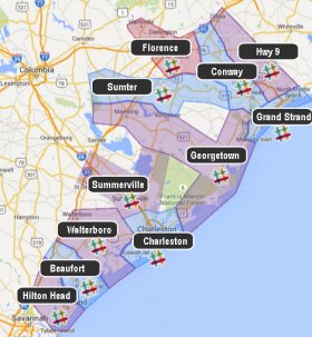
MapRaid SC Beachcomber Raid will be 21 June at 17:00 UTC (1:00 PM EDT) through 28 June 2015. The map raid will be divided into several groups, one for each section. Each group will have both local and senior editors, one of which will be the "Group leader" - listed in blue below. Please direct all questions to your group leaders. The raid hosts will be available across all areas for added support.
You will also be given a super region. Your goal as raiders should be to get your assigned area as complete and through as possible. Please don't edit outside your assign area unless directed to or with permission from a local host.
Mission
Our mission is to handle
- Functional Classification
- Places, especially in resort areas.
- URs, MPs, and general map verification
Mapraid managers
Every editor rank 3 and up from the state who has AM area and has been active recently and is participating in this MR will be listed as a host.
| Editor | Location | Roles |
|---|---|---|
| orbitc(6) [PM [Help]] |
Regional Coordinator | Map Raid Organizer |
| HavanaDay(6) [PM [Help]] |
Map Raid Organizer | |
| crazycaveman(5) [PM [Help]] |
Map Raid Organizer | |
| ialangford(5) [PM [Help]] |
Map Raid Organizer |
About this map raid
Please read the entire MapRaid wiki. If you are still uncertain what to do about something you see on the map, please ask your group leader Thank You for your help with the map.
What NOT to do
- Mass Edit
- DO NOT perform edits that affect large numbers of segments at once. We want to know who fixed what so we can understand how problems got resolved.
- Add wayfinders
- If you are 100% certain a wayfinder is needed, please ask HavanaDay, CrazyCaveman, or ialangford.
Group areas
You have editing access to a super region. Please stay within your assigned group area. If your group area is completely done, your group leader will assign you to one of the other groups for the remainder of the raid. Please use the mapraid overlay extension to keep track of your group area boundaries.
Mapraid UR Rules
We will follow the usual US UR etiquette with one exception: During the Map raid, the wait time is reduced to 4 days.
Do not close URs if the UR contains a tag such as [NOTE], [CLOSURE], or any other [MESSAGE]. Ask the editor who created the tag.

Micro-Doglegs
We use micro-doglegs to control turn- vs. stay/keep/exit instructions. Zoom in very close to see the closely-spaced geometry nodes. Preserve them.
Cities
In South Carolina, all incorporated cities and towns are mapped as cities. City names should only be added to segments located on or within the borders of the city or town.
We also will map some CDP’s (Census-Designated Places) depending on the local zip code. When one goes to the [USPS Zip Code Lookup], one can search cities by zip code. When a zip code is typed into the search, the system will return multiple names. The first name is the Zip Code’s default city, after that other recognized city names, and finally a list of unacceptable city names. If a CDP’s name is the same as a default or recognized city name, it should be mapped to the CDP’s declared boundaries; if a CDP’s name is an unacceptable name or not listed, it should not be mapped.
Some military bases may also be mapped as cities in South Carolina. Do not try to add or remove military city polygons.
No unincorporated communities that are not CDP’s are mapped in South Carolina, regardless of Zip Codes.
For place addresses, the city name should match the name of the city or town it is located in. If located in a CDP that is mapped because of a Zip Code, the place should use that name. If located in a CDP that is not mapped or other unincorporated areas, the place should use the default city of its Zip Code.
Road Types, Names, and Functional Classification (FC)
In South Carolina , we follow the general US standards for road types based on the hybrid rule of FC and Route Type.
Some notes:
- South Carolina Highways: SC-###.
- State highway secondary system S-46-18 -- used as alternate name only.
- The route number is a combination of county code (46) and road number (18)
- If there is no other name on the sign, then the primary name should be Rd 18
- If an interstate exit says County Rd 18, it is actually for a state secondary
- County Road: CR-537, CR-4 are usually not signed. Only use this as the primary name if it appears on signs.
- If it is called County Rd XXX it is NOT a county road -- it is usually a state secondary route (see above)
- For SC and S numbers ONLY, use the SCDOT streetfinder
- You can read more about road naming in South Carolina
- If a road has more than one name follow the standard for Concurrent names on US roads.
- Where roads cross divided roadways, the section crossing the median should have no name. The "none" box should be checked. Read more about a connecting street between the lanes of a divided highway.
Road Locks
| Segment Type | Default locks |
|---|---|
| Freeway | 5 |
| Ramp | Highest rank of connected segment |
| Major Highway | 4 |
| Minor Highway | 3 |
| Primary Street | 2 |
| Street | 1 |
| • • • • Ferry • • • • | 5 |
| |-|-|-|-|-|-|-|-|-| Railroad |-|-|-|-|-|-|-|-|-| | 2 |
Places
Please bring places up to standard -- correct names, categories, addresses, locations, and remove inappropriate photos. Follow the US standard for places, except as noted below.
Chain Harmonization Sheet
- The name spellings in the following sheet have been standardized for chains or franchises so that Wazers will receive consistent results when searching in the client. Please use them when you edit one of these chain or franchise businesses. Websites and descriptions have also been included for many of them. If you have any thoughts on a effective and short description for a location please let us know.
- Missing Chains
- If you don't find the business you're looking for, please use this form to submit the missing information and PM ialangford and replace "Place" with the one you added.
View this list full-screen in Google Sheets
- Use the Places Browser to help you catch possible mistakes.
- Please lock places to 3 once you have corrected all of the following:
- Destination point
- Categories
- Address
- Name
Exceptions to the US standards for places:
The following are NOT mapped in South Carolina:
- interchanges/junctions
- water (if a major body of water that is missing from the map, ask the RC or an SM)
- islands
- beaches
- toll plazas
Left Turns
- Left turns are allowed unless
- a posted sign prohibits the left turn or
- there is a median.
Mapping Resources
- NFC maps (GIS)
- City boundary/CDP boundary maps
- SCIWAY County GIS links
- State list of County and City GIS contacts and maps (where available)
- For State Highway and secondary highway route numbers (SC-XXX and S-XX-XX) ONLY, use the SCDOT streetfinder. Do not use this map for any other purpose.
County Maps
- 7 Beaufort
- 8 Berkeley
- 10 Charleston
- 14 Clarendon
- 15 Colleton
- 16 Darlington[b]
- 17 Dillon
- 18 Dorchester
- 21 Florence
- 22 Georgetown
- 25 Hampton[a]
- 26 Horry
- 27 Jasper[a]
- 34 Marion
- 38 Orangeburg
- 43 Sumter
- 45 Williamsburg
Communication
We will use #Slack Channels. There is a South Carolina Raid general channel and also a channel for each raid group. Please be sure to join the slack WazeMapRaid Team and join the channels for the specific MapRaid and group you are assigned to. If you are not already part of the WazeMapRaid slack team, Click here to get your Slack invitation. Be sure to choose WazeMapRaid to the MapRaid question. If you have trouble getting into the slack team and channels, please reach out to one of the MapRaid organizers.
WME chat can also be used. The WME Chat addon is recommended.
Reference Links
The Basics
- New editor welcome page
- Waze Map Editor
- Best Map Editing Practice
- Editing manual
- Common editing mistakes
- How to make a Permalink
- All about using the WME Chat
- Community Plugins, Extensions and Tools where you'll links and descriptions to most of the editing scripts being used. Some of these are essential to good editing, and others make the editing process much easier. WME Validator and URO+ are highly recommended.
Recommended Tools for MapRaid
- mapraid overlay tampermonkey/greasemonkey required
- Map Raid Place Browser
- UR Comments - a tremendous time and labor saving tool with automation and integration with URO+, to help with working URs. Read the documentation. Tampermonkey / greasemonkey required
- The WME Reference Sheet[PDF] is a printable double-sided tri-fold quick reference guide to some of the common topics used in WME.
- Validator is a script that validates a map area in Waze Map Editor, highlights issues and generates a very detailed report with wiki references and solutions.
- Chrome browser: please download the script at Chrome Web Store
- Firefox browser: please download the script at GreasyFork.org -- tampermonkey or greasemonkey required
- There is also a SC Localization for Validator available. You will need Tampermonkey or Greasemonkey installed (in addition to Validator) in order to use it.
- WME Chat Addon is a script that improves the WME chat GUI. For a list of all the features check the thread here -- Tampermonkey/Greasemonkey required
Groups
Results
| Check back here after the raid is completed to see the results and achievements |
MapRaid Promotions
Some editors really let their bright side out and let their community skills shine. This is even more evident during a concerted group effort with high-density editing that happens during a MapRaid!. When editors of all ranks work closely with each other and the Champs, this really lets everyone get to know each other, and allows certain editors to be recognized for their skill and effort.
When the Champs see someone consistently editing well, interacting well with the community, and showing knowledge of the various details from the Wiki, they can issue promotions. This can be anything from managed area size increase, to a rank increase, or even a new role.
| Watch here for results of promotions during and after the raid. |