This special page shows all uploaded files.
| Date | Name | Thumbnail | Size | Description | Versions |
|---|---|---|---|---|---|
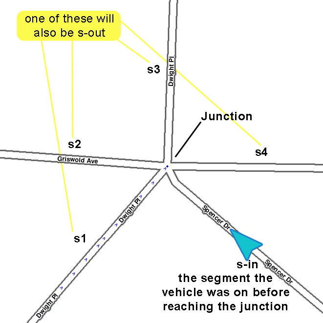
| 21:48, 4 May 2014 | S-in s-out definition.jpg (file) |  |
90 KB | Graphically define segment names in the Best Continuation algorithm. | 1 |
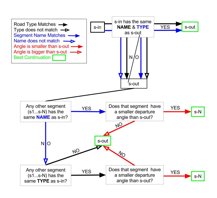
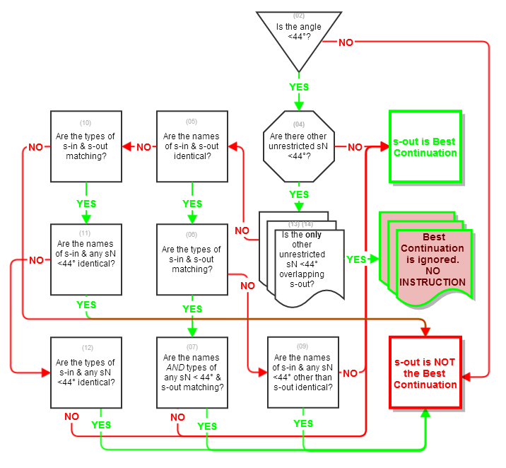
| 21:53, 4 May 2014 | Best Continuation algorithm.jpg (file) |  |
76 KB | Flowchart defining the steps the algorithm runs through to determine the 'Best Continuation' segment at a junction. | 1 |
| 23:31, 2 June 2014 | Nav icon turn right.JPG (file) | 4 KB | Waze client navigation icon for turn right instruction. | 1 | |
| 23:32, 2 June 2014 | Nav icon turn left.JPG (file) | 4 KB | 2 | ||
| 14:35, 3 June 2014 | Turn left agc.png (file) |  |
117 KB | A left turn to an AGC center turn lane with dogleg | 1 |
| 14:37, 3 June 2014 | Turn left angle.png (file) |  |
192 KB | Shallow angle left turn | 1 |
| 14:40, 3 June 2014 | Keep right ps to ramp.png (file) |  |
187 KB | Slight right turn from primary street to ramp | 1 |
| 14:44, 3 June 2014 | Keep left ps to ps bc.png (file) |  |
187 KB | Slight left primary street to primary street best continuation | 1 |
| 14:53, 3 June 2014 | Exit right ramp to ramp.png (file) |  |
266 KB | Slight EXIT right ramp to ramp | 1 |
| 14:56, 3 June 2014 | Exit left ramp to ramp.png (file) |  |
266 KB | Slight exit left ramp to ramp | 1 |
| 15:07, 3 June 2014 | Turn right.png (file) |  |
126 KB | Turn right major highway to street | 1 |
| 17:25, 3 June 2014 | Turn right AGC no arrow.JPG (file) | 22 KB | 1 | ||
| 07:45, 8 June 2014 | Nav icon roundabout x.JPG (file) | 5 KB | 1 | ||
| 07:46, 8 June 2014 | Nav icon roundabout left.JPG (file) | 4 KB | 1 | ||
| 07:47, 8 June 2014 | IMG 20140608 034243.JPG (file) |  |
4 KB | 1 | |
| 07:48, 8 June 2014 | Nav icon roundabout straight.JPG (file) | 4 KB | 1 | ||
| 07:48, 8 June 2014 | Nav icon roundabout 1.JPG (file) | 6 KB | 1 | ||
| 07:52, 8 June 2014 | Nav icon roundabout 2.JPG (file) | 7 KB | 1 | ||
| 07:53, 8 June 2014 | Nav icon roundabout 3.JPG (file) | 7 KB | 1 | ||
| 07:54, 8 June 2014 | Nav icon roundabout 4.JPG (file) | 6 KB | 1 | ||
| 07:54, 8 June 2014 | Nav icon roundabout 5.JPG (file) | 6 KB | 1 | ||
| 07:55, 8 June 2014 | Nav icon roundabout 6.JPG (file) | 6 KB | 1 | ||
| 23:33, 12 June 2014 | Nav icon roundabout u turn.jpg (file) | 4 KB | 1 | ||
| 08:17, 13 June 2014 | Turn angle.png (file) |  |
44 KB | 1 | |
| 16:41, 13 June 2014 | Turn angle geo line.png (file) |  |
53 KB | illustration of a turn angle with geo node dogleg | 1 |
| 16:41, 13 June 2014 | Turn angle 37.png (file) |  |
41 KB | 37° turn angle | 1 |
| 21:13, 17 June 2014 | WME Chat minimized visible new.JPG (file) |  |
2 KB | Cropped tighter | 3 |
| 21:21, 17 June 2014 | WME Chat minimized invisible new.JPG (file) |  |
2 KB | Cropped tighter | 4 |
| 21:23, 17 June 2014 | WME Chat minimized invisible no new.JPG (file) |  |
2 KB | Cropped tighter | 3 |
| 03:32, 18 June 2014 | WME Chat addon minimized alert.png (file) |  |
918 bytes | 1 | |
| 03:33, 18 June 2014 | WME Chat addon full alert.png (file) |  |
39 KB | 1 | |
| 20:25, 18 June 2014 | Permalink small.jpg (file) |  |
13 KB | 1 | |
| 00:39, 23 June 2014 | Best continuation.png (file) |  |
60 KB | changed 45 deg to 44 deg | 4 |
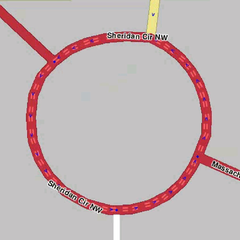
| 15:43, 1 July 2014 | Abnormal roundabout 1.JPG (file) |  |
71 KB | Roundabout with more than 4 nodes | 1 |
| 15:54, 1 July 2014 | Abnormal roundabout 2.JPG (file) |  |
96 KB | Not normal angles | 1 |
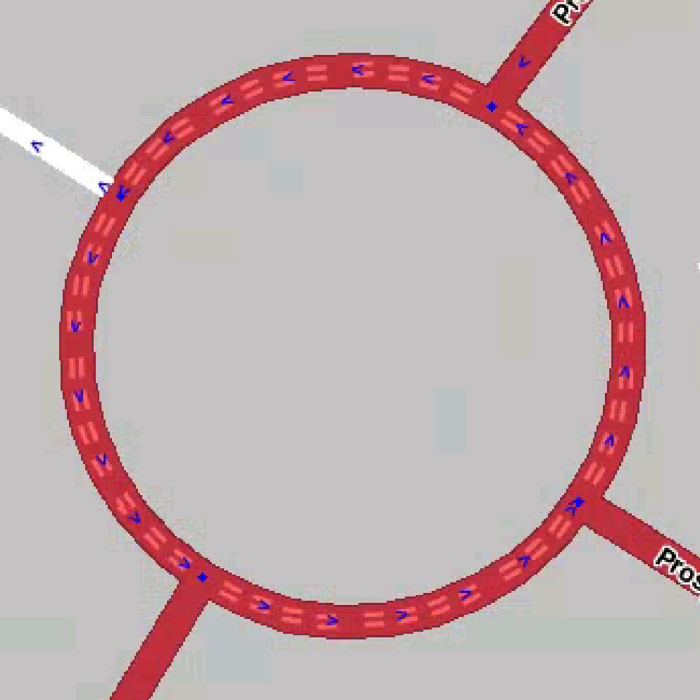
| 16:05, 1 July 2014 | Normal roundabout 1.JPG (file) |  |
97 KB | 4 nodes | 1 |
| 16:09, 1 July 2014 | Abnormal roundabout 3.JPG (file) |  |
82 KB | >4 nodes | 1 |
| 23:55, 6 July 2014 | PesachZ map editors night.png (file) |  |
688 KB | 1 | |
| 06:03, 8 July 2014 | Night blue.png (file) |  |
687 KB | 1 | |
| 06:50, 8 July 2014 | PesachZ Map editors.txt (file) | 5 KB | to install, download, rename as "schema" and place in proper folder. | 1 | |
| 06:55, 8 July 2014 | PesachZ Map editors night.txt (file) | 5 KB | Download, rename as "schema", install in correct folder | 1 | |
| 07:00, 8 July 2014 | PesachZ Night Blue.txt (file) | 5 KB | Download, rename as "schema" and install in proper folder. Color Scheme | 1 | |
| 21:51, 10 July 2014 | PesachZ map editors night 2.png (file) |  |
716 KB | 1 | |
| 22:03, 10 July 2014 | PesachZ map editors 2.png (file) |  |
765 KB | 1 | |
| 21:55, 17 July 2014 | Garminesque day.png (file) |  |
137 KB | 1 | |
| 21:56, 17 July 2014 | Garminesque night.png (file) |  |
171 KB | 1 | |
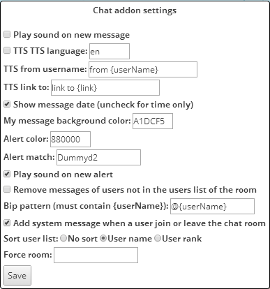
| 14:53, 25 July 2014 | WME Addon settings.png (file) |  |
15 KB | version 0.6 | 5 |
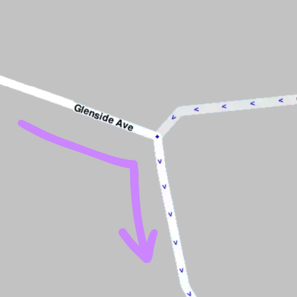
| 20:37, 25 July 2014 | Turn angle geonode.png (file) |  |
26 KB | 1 | |
| 14:36, 28 July 2014 | 3-way turn junction.png (file) |  |
98 KB | 1 | |
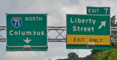
| 02:34, 29 July 2014 | Wayfinder continuation TO I-71.png (file) |  |
142 KB | The left branch of this wayfinder should be named "To I-71 N / Columbus" because after you pass it you are still on I-471. | 1 |