No edit summary |
Kentsmith9 (talk | contribs) m (Removed USA subpage links) |
||
| (129 intermediate revisions by 13 users not shown) | |||
| Line 1: | Line 1: | ||
'''MapRaid! | {{mbox|image=[[File:clock.png|40px]] | ||
|text='''MapRaid!Dallas,Texas''' {{#ifexpr:{{#time:xNU|2015-02-13T0000}}>{{#time:xNU|}}<!-- check if raid started yet--> | |||
|will begin on '''2015-02-13, Friday. 00:00 UTC'''. The raid will last for roughly 7 days.<br>{{red|'''Please do not make any edits in the raid area until after the raid begins (00:00 UTC)}}<!--text to show before raid starts--> | |||
|has begun on '''2015-02-13, Friday. 00:00 UTC'''. The raid will last for roughly 7 days.}}<!--text to show after raid starts-->}} | |||
{{Mbox|image=[[File:Application clipboard.png|40px]]|text={{#ifexpr:{{#time:xNU|2015-01-22T0500}}>{{#time:xNU|}}|'''Registration is now open for MapRaid! DFW. If you would like to participate please fill out [http://docs.google.com/forms/d/1G2cjP6yySf-6koq5U8QK6oz2fzATbXQL26HNHFqGuOw/viewform this form] before 2015-01-21 05:00 UTC.'''|Registration for the MapRaid! is now closed. To hear about future MapRaids please join the [http://wazemapraid.slack.com MapRaid ''#''Slack].}}}} | |||
{{mbox | {{mbox | ||
| type = critical | | type = critical | ||
| | | text = {{red|'''''Please be sure to explore this Wiki page, and <!-- | ||
| | ---------------------------- | ||
REMOVED because page is now transcluded to bottom of this page | |||
[[Texas/Mapraid/15-01-Houston|the specific page for the Houston Jan '15 raid]]. Also, | |||
------------------------------> check back regularly in case of added materials.'''''}}<br>'''You are only seeing modifications of this page made up until {{#time:D, j M Y H:i:s T}}, make sure to {{U|log in to the wiki}} to see the latest updates.''' | |||
}} | }} | ||
-- | <!-- After changing the link in the box above to point to a new MapRaid! page, delete this comment line so the following is left on the page: | ||
[[ | ''To see the results, and other information specific to MapRaid in Houston during Jan 2015, see the [[Texas/Mapraid/15-01-Houston|archived page]].'' | ||
--> | |||
==Welcome to Texas!== | ==Welcome to Texas!== | ||
=== | == Mission == | ||
Our primary mission is to fix what is broken as well as fine tune what is already working. This will be handled through a variety of ways: | |||
* Handling URs and MPs | |||
* Fixing streets (correcting elevation, turns, extra nodes, alternate names, etc) | |||
* Routing corrections (usually found in URs or by randomly attempting to route between points and looking for irregularities) | |||
* FC errors (but do not downgrade without getting local guidance! See FC warning immediately below.) | |||
<!-- '''PURs, followed by Place validation, are being handled EXCLUSIVELY by Team 10, please refer all places updates to them.''' --> | |||
{{mbox | {{mbox | ||
| type = critical | | type = critical | ||
| small = left | | small = left | ||
| textstyle = color: red; font-weight: bold; font-style: italic; | | textstyle = color: red; font-weight: bold; font-style: italic; | ||
| text = Functional Classification (FC) has been fully implemented for the | | text = Functional Classification (FC) has been fully implemented for the MAPRAID area. Some road types may deviate intentionally from the state DOTs classifications. Please consider contacting a local champ or State Manager (SM) before downgrading a road type. | ||
| smalltext = Text for the top of article sections. | | smalltext = Text for the top of article sections. | ||
}} | }} | ||
| Line 37: | Line 38: | ||
{{Username|txemt}} - South Central Regional Coordinator - available | {{Username|txemt}} - South Central Regional Coordinator - available | ||
{{Username|jasonh300}} -South Central Regional Coordinator- | <!-- {{Username|jasonh300}} -South Central Regional Coordinator- removed pending response form editor if he wishes to participate --> | ||
{{Username|driving79}} -Southeast Regional Coordinator- | {{Username|driving79}} -Southeast Regional Coordinator- | ||
{{Username|pjlasl}} - US Champ, US CM, Texas SM - | {{Username|pjlasl}} - US Champ, US CM, Texas SM - ''Currently Unavailable'' | ||
{{Username|ctpoole}} - Texas SM | {{Username|ctpoole}} - Texas SM | ||
{{Username|karlcr9911}} - Texas SM | {{Username|karlcr9911}} - Texas SM | ||
{{Username|jakflash}} - Houston area editor | {{Username|jakflash}} - Houston area editor | ||
{{Username|coontex}} - Houston area editor | {{Username|coontex}} - Houston area editor | ||
==Important!== | ==Important!== | ||
'''Please do not alter any of the following road ''types'' without first consulting a [[#Local Hosts | Local Host]]''': Freeway, Ramp, Major Highway, minor Highway, Primary Street. | '''Please do not alter any of the following road ''types'' without first consulting a [[#Local Hosts | Local Host]] (unless changes are being made to match Functional Classification (FC))''': Freeway, Ramp, Major Highway, minor Highway, Primary Street. You may edit these roads, but do not change the type of the segment (excluding FC work). Confirmation should be obtained before making changes to any of these road types that go '''''against''''' FC. | ||
'''Please do not mass-edit''' Do not perform edits which will affect large numbers of segments at once. The edit history of segments is highly valuable in the process of solving URs. Mass editing effectively mass erases this history, permanently. We ask that all necessary processes which might affect large portions of the map, or long stretches of roads, be reserved until near the end of the MapRaid. This includes the “Select entire street” function. | '''Please do not mass-edit''' Do not perform edits which will affect large numbers of segments at once. The edit history of segments is highly valuable in the process of solving URs. Mass editing effectively mass erases this history, permanently. We ask that all necessary processes which might affect large portions of the map, or long stretches of roads, be reserved until near the end of the MapRaid. This includes the “Select entire street” function. To facilitate this process in an orderly fashion, we have the [[#Scheduled Edits|Scheduled Edits list]] below. Please document any mass edits which are required, and you will be given first chance to make those edits when the time is right. | ||
'''Anything locked at 5 or 6?''' Please check with a local editor before making changes. | '''Anything locked at 5 or 6?''' Please check with a local editor before making changes.<br /> | ||
If you are a rank 5 or 6 editor - consider keeping highlights active for locks 5 and 6. | |||
'''Close nodes''' We make extensive use of the "micro-dogleg" technique, where a geometry node is carefully placed, at full zoom, directly next to a junction node, in order to set the angle to create a desired Turn/Stay/Exit prompt. Please watch for these if you move any junction node, and be sure to recreate the same angle at the new location. | '''Close nodes''' We make extensive use of the "[[Glossary#mDL | micro-dogleg]]" technique, where a geometry node is carefully placed, at full zoom, directly next to a junction node, in order to set the angle to create a desired Turn/Stay/Exit prompt. Please watch for these if you move any junction node, and be sure to recreate the same angle at the new location. | ||
==Local Guidance== | ==Local Guidance== | ||
| Line 66: | Line 66: | ||
===Functional Classification=== | ===Functional Classification=== | ||
'''Functional Class''': [http://www.txdot.gov/apps/statewide_mapping/StatewidePlanningMap.html TxDot Functional Class] Look for FC along the right hand side. | |||
The Functional Classification has been completed in the | In the United States, we set our road types using a national standard called Functional Classification (FC). You can read a detailed explanation in our [[Road types#Functional_classification|Road Type Wiki]] | ||
The Functional Classification has been completed in the DFW Area. Occasionally, we find short segments that were missed in the selection process for conversion, and it is important that these be corrected for routing continuity. If you see FC wrong, please correct it if you're 100% sure it's wrong. If you're not sure, please ask a local, karlcr9911, or txemt. In isolated cases, we have chosen to deviate from official classifications, due to errors or outdated information in the TxDot FC maps, or to better accommodate real-life situations and Waze quirks. It is important that these remain intact. Sometimes dirt roads may appear higher on FC maps but shouldn't be used by Waze for routing. | |||
If you find an area that doesn't seem to be complete please bring it to the attention of a Local Host for review. | If you find an area that doesn't seem to be complete please bring it to the attention of a Local Host for review. | ||
'''TxDot functional classification classifies roads as''' | |||
*An Interstate, Principal Arterial Freeway & Expressway is a {{Freeway}} | |||
*Any road that acts, looks, & feels like a freeway should be set to {{Freeway}} road type. | |||
*An Principal Arterial-Other is a {{Major Highway}} | |||
*An Minor Arterial is a {{Minor Highway}} | |||
*An Collector is a {{Primary Street}} | |||
*All other roads are to be classified as {{Street}} | |||
{{ | === Locking Standard === | ||
{{Lock Standard State|TX}} | |||
===Elevation=== | |||
In general, all freeways should have an elevation of ground. Roads running over or under the freeways will have an elevation of +1 or -1. Where two freeways cross, the overpass should generally have +1 elevation. More complicated junctions may need more complicated treatment; apply the principal of "freeway defines ground level whenever possible" and keep elevations as sensible as possible. Remember that this region is not very hilly. | |||
===UR & MP Guidance=== | |||
<!--------------------------- old text from LA | |||
As the MapRaid Texas begins, the greater Houston area has over 6,000 open Update Requests (URs) and over 500 Map Problems (MPs); some of the URs are older than 300 days. Investigating and responding to these URs and MPs will be a primary objective of the MapRaid teams. Therefore, a [[California/Map_Raid_LA/UR_Guidance|UR Guidance]] page has been created to help guide teams through the maze of MPs and URs.<br /> | |||
---------------------------------------> | |||
Responding to Update Requests (URs), and Map Problems (MPs) will be the primary focus of the MapRaid teams. Please make sure to follow the guidance on dealing with URs and MPs as they are clearly explained in the [[UR|UR wiki page]]. Be especially careful to always leave a comment when closing a UR to explain why you are closing it, or how you fixed it. ''If there is no problem with the map to fix, don't mark it as solved, mark is Not Identified".''<br /> | |||
'''Our only variation for the MapRaid from the [[UR|general guidance on handling URs]], is that we are reducing the 7 day wait periods to 3 days.''' You still must comment and wait 3 days, then comment again before closing a UR as "Not Identified". If you are able to fully diagnose and fix the problem, then comment what the fix was, and close it as "Solved". | |||
'''We should not be sending ''reminder'' comments after the 3 days.''' We send one comment asking for info, if there is no response after 3 days, close the UR. Please try to solve the UR, if that's not possible mark it as ''Not Identified''. ''(We should still be sending a closing comment before closing, and it's OK to send follow up comments if you need additional information after the first response.)'' | |||
As per [[Texas#User Reports (URs)|Texas UR policy]] please keep UR response comments to a minimum, short and to the point. Aim for not more than 3-4 lines total. The [[#Recommended Tools|UrComments script (link below)]] already has a long list of canned UR responses which have been vetted by a group of senior editors. | |||
<!--#####This box will only appear on the page after 2015-02-15 23:00 UTC | |||
-->{{#ifexpr:{{#time:xNU|2015-02-15T2300}}<{{#time:xNU|}}|{{mbox | |||
| textstyle = color: black; font-weight: bold; | |||
| text = As we have now reached 3 days since the beginning of the Raid, and URs are being closed, please double check that the UR you are closing still is not/cannot be solved. Sometimes a question has been left for verification, and a map correction delayed, pending a response/no response. Please make sure to attempt to fix or get help if need before closing any UR. | |||
Also, DO always leave a closing comment; no UR should be closed without one. | |||
}} }} | |||
===Place Editing=== | ===Place Editing=== | ||
<!-- {{mbox|type=critical|text='''{{red|NOTE:}} All Places edits should be handled EXCLUSIVELY by [http://wazemapraid.slack.com/messages/-mr_hou_team10/ Team 10 - PURs, Waze Sheets].'''}} --> | |||
Not only were our URs and PURs out of control, | Not only were our URs and PURs out of control, Places from both editors and trusted users have become a major issue. Misspelled names, wrong categories, missing addresses ''(EVERY business place should have an address!!)'', poor location, and incorrectly assigned photos are all over the map. Use the powerful [[#Recommended Tools|Place Browser (link below)]] and the information on the [[Texas#When_to_use_Area_or_Point_in_Texas|'''Place editing''']] section of the Texas page to get these places corrected. | ||
Please use good judgement when approving photos. Any photo which has nothing to do with the actual place, reject. This is including, but not limited to body parts, car parts, bathrooms, children, & animals. If you're not sure, please ask one of the senior editors. | Please use good judgement when approving photos. Any photo which has nothing to do with the actual place, reject. This is including, but not limited to body parts, car parts, bathrooms, children, & animals. If you're not sure, please ask one of the senior editors. | ||
'''Gas Stations'''<br> | '''Gas Stations'''<br> | ||
Gas Stations should be locked to level 3 but, only after all data fields in the gas station have been filled. At least ensure that Brand, Name and Address have information. Remember to ask a | Gas Stations should be locked to level 3 but, only after all data fields in the gas station have been filled. At least ensure that Brand, Name and Address have information. Remember to ask a [[#Local Hosts|local host]] if you need help identifying gas station information. | ||
For editors below rank 3, once you have completely filled out a gas station with the | For editors below rank 3, once you have completely filled out a gas station with the minimum required information, please lock to your level and then ask for a lock request. | ||
===Toll Roads / HOV / HOT | Finally, DO NOT USE THE BRAND "UNBRANDED". If it is a no brand gas station, just leave the brand field blank. | ||
'''Locking Standard''' | |||
*Lock at rank 5: hospitals, universities, park and ride lots, arenas, airports. | |||
*Lock at 3: any other place that has at least a correct category correct name, and correct address with house number.. | |||
*If you cannot lock high enough because of rank, lock as high as you can, and get help from a higher-ranked editor to lock properly. You can keep a personal list of [[Permalink]]s to share with the other editor. | |||
===Toll Roads / HOV / HOT=== | |||
It is our custom to mark the toll checkbox on the entire sections of Toll Roads to include those ramps which are tolled. HOV and HOT road types have already been set correctly according to our local practices. If you have a question about one of these lanes, please contact a [[#Local Hosts | Local Host]]. | It is our custom to mark the toll checkbox on the entire sections of Toll Roads to include those ramps which are tolled. HOV and HOT road types have already been set correctly according to our local practices. If you have a question about one of these lanes, please contact a [[#Local Hosts | Local Host]]. | ||
| Line 113: | Line 132: | ||
===Construction=== | ===Construction=== | ||
DFW Is going through an explosion of neighborhoods and new subdivisions. There may be some of these which are not on the editor, so if you see a missing road, see if there is an actual neighborhood by turning on the GPS tracks. There are a number of major construction projects in process within the overall MapRaid area. These construction projects can cause frequent intermittent road closures. Many closures change daily and cause great numbers of URs to appear. When handling URs in one of these areas, be aware that reports of "Turn not allowed", "Missing road", "Wrong driving direction" are common, but may not indicate a map problem that can be fixed, because the physical road situation will change before our edits can take effect. | |||
LINKS: | LINKS: | ||
| Line 119: | Line 138: | ||
[http://drivetexas.org Texas driving conditions and road construction] | [http://drivetexas.org Texas driving conditions and road construction] | ||
[http://www.txdot.gov/inside-txdot/projects/studies/houston.html Houston area road construction] | <!-- [http://www.txdot.gov/inside-txdot/projects/studies/houston.html Houston area road construction] | ||
[http://www.i69texasalliance.com/ I-69] US-59 is being converted to interstate standards to become I-69. They have officially designated US-59 as I-69 through most of the Houston area already, but TxDot has been slow to make the changes on the signs. If there are any URs about US-59 not being I-69, simply explain TxDot has been slow to make changes. There are many maps which have already shown the changes through the area. | [http://www.i69texasalliance.com/ I-69] US-59 is being converted to interstate standards to become I-69. They have officially designated US-59 as I-69 through most of the Houston area already, but TxDot has been slow to make the changes on the signs. If there are any URs about US-59 not being I-69, simply explain TxDot has been slow to make changes. There are many maps which have already shown the changes through the area. | ||
--> | |||
===U-turns=== | ===U-turns=== | ||
In Texas, U-turns are generally allowed unless unsafe, or specifically denied by signage. In general we can confirm, lock or "harden" U-turns (click to remove the Purple question mark indicating a soft turn -- see [[Turn_restrictions#Turn_restrictions|the Wiki]]) | In Texas, U-turns are generally allowed unless unsafe, or specifically denied by signage. In general we can confirm, lock or "harden" U-turns (click to remove the Purple question mark indicating a soft turn -- see [[Turn_restrictions#Turn_restrictions|the Wiki]]). U-turns are not named unless there as an official sign. All U-turns along freeways are normally named "Turnaround." | ||
===Alleys=== | ===Alleys=== | ||
Alleys are '''not mapped''' in the State of Texas | Alleys are '''not mapped''' in the State of Texas and '''should be deleted'''. This has been confirmed per txemt. | ||
=== | ===Private Roads=== | ||
Private roads are used only for specific purposes. Before creating new private roads or working with existing private roads, please consult txemt. | |||
===Cameras=== | ===Cameras=== | ||
| Line 148: | Line 159: | ||
'''Speed Cameras''' are illegal to use in the State of Texas | '''Speed Cameras''' are illegal to use in the State of Texas | ||
Red light cameras | '''Red light cameras''' Are used in various places -- check for information for each municipality.<br /> | ||
For a list of DFW cameras, please click here: [[#Cameras_2 | DFW Cameras]] | |||
==Mapping Resources== | ==Mapping Resources== | ||
'''Functional Class''': [http://www.txdot.gov/apps/statewide_mapping/StatewidePlanningMap.html TxDot Functional Class] | |||
== Communication == | |||
Communication will be handled primarily in ''#''Slack Channels and WME chat can also be used. The [http://www.waze.com/forum/viewtopic.php?f=819&t=95038 WME Chat addon] is recommended. | |||
Special Slack channels will be set up and named by raid location and group. {{U|Please be sure to join the slack WazeMapRaid Team and join the channels for the specific MapRaid and group you are assigned to.}} | |||
'''Click here to get your [http://bit.ly/GetWazeSlackInvite Slack invitation]. Be sure to choose {{u|WazeMapRaid}} to the MapRaid question.''' | |||
If you have an issue getting into the slack team and channels, please reach out to one of the [[#Team members|MapRaid organizers]]. | |||
=== Unlock and lock requests === | |||
Unlock and lock requests should be handled in your teams slack channel. Each team has at least one rank 5 editor, most have more, and all but one team has a rank 6 editor. If you cant get a response in your teams channel, you can try the [http://wazemapraid.slack.com/messages/-dallas-general/ general MapRaid! Dallas channel]. | |||
Due to the close group and rapid time frame for editing, we can accomplish things much faster if we handle it all in-house. There is no need to post unlock requests to the forum for MapRaid! related edits. | |||
Unlock requests should include the permalink preferably without layers, the changes you would like to make, and the reasoning behind the changes you'd like to make. | |||
== Reference Links == | == Reference Links == | ||
| Line 203: | Line 193: | ||
*[[WME Chat|All about using the WME Chat]] | *[[WME Chat|All about using the WME Chat]] | ||
*[[Community Plugins, Extensions and Tools]] where you'll links and descriptions to most of the editing scripts being used. Some of these are essential to good editing, and others make the editing process much easier. WME Validator, URO+, and WME Toolbox are highly recommended. | *[[Community Plugins, Extensions and Tools]] where you'll links and descriptions to most of the editing scripts being used. Some of these are essential to good editing, and others make the editing process much easier. WME Validator, URO+, and WME Toolbox are highly recommended. | ||
*[ | *[[Texas|Texas Wiki]] | ||
=== Recommended Tools | === Recommended Tools === | ||
* The [ | * The [//greasyfork.org/en/scripts/7509-wme-mapraid-dallas-raid-overlay Dallas MapRaid Group/Region Overlay] is available on GreasyFork to indicate the Group areas on the map as you work. You will need TamperMonkey (Chrome) or GreaseMonkey (Firefox) to install and use this. <small>By: {{Username|Davielde}}, updated by {{Username|Rickzabel}}</small> | ||
* [ | * [[User:Rickzabel/URComments|UR Comments] - a tremendous time and labor saving tool with automation and integration with URO+, to help with working URs. Read the documentation. <small>By: {{Username|Rickzabel}}</small> | ||
* [http:// | * [http://w-tools.org/PlaceBrowser?group=MapRaidDallas Place Browser] - This tool lists all places in the specified area, and flags some things that MIGHT be problems. It is up to you to decide what to do with this information. Be sure to apply the global, national, and local guidelines for places. Be sure to click the About tab to get an overview of the tool. <small>By: {{Username|Joyriding}}</small><!-- <br>'''{{red|NOTE:}} All Places edits should be handled EXCLUSIVELY by Team 10 - PURs, Waze Sheets.''' --> | ||
* The [http://drive.google.com/file/d/0B8WbeRGWGEOjQ1BvbHFtYlJSV2pIOVdyQlgtRmJzQUtHNjRz WME Reference Sheet<sup><small><nowiki>[PDF]</nowiki></small></sup>] is a printable double-sided tri-fold quick reference guide to some of the common topics used in WME. | * The [http://drive.google.com/file/d/0B8WbeRGWGEOjQ1BvbHFtYlJSV2pIOVdyQlgtRmJzQUtHNjRz WME Reference Sheet<sup><small><nowiki>[PDF]</nowiki></small></sup>] is a printable double-sided tri-fold quick reference guide to some of the common topics used in WME. <small>By: {{Username|Xevell}}</small> | ||
* [ | * [http://www.waze.com/forum/viewtopic.php?t=76488 Validator] is a script that validates a map area in Waze Map Editor, highlights issues and generates a very detailed report with wiki references and solutions.<br>Download links: | ||
Download links: | ** For Chrome browser please download the script at [http://chrome.google.com/webstore/detail/wme-validator/baojhpeknpmkhplkcnpdcficcaaniaih Chrome Web Store] | ||
** For Firefox browser please download the script at [http://greasyfork.org/scripts/1571-wme-validator GreasyFork.org]<br>''Note: for Firefox browser you also need Greasemonkey or Tampermonkey installed.'' | |||
''Note: for Firefox browser you also need Greasemonkey or Tampermonkey installed.'' | |||
* [http://greasyfork.org/en/scripts/2103-wme-chat-addon WME Chat Addon] is a script that improves the WME chat GUI. For a list of all the features check the thread [ | * [http://greasyfork.org/en/scripts/2103-wme-chat-addon WME Chat Addon] is a script that improves the WME chat GUI. For a list of all the features check the thread [http://www.waze.com/forum/viewtopic.php?f=819&t=95038 here]. <small>By: {{Username|Dummyd2}}</small> | ||
** Tapermonkey/Greasmonkey is required to use this script | |||
---- | ---- | ||
{{Mbox|type=forum|text=Click [http://www.waze.com/forum/viewtopic.php?f= | {{Mbox|type=forum|text=Click [http://www.waze.com/forum/viewtopic.php?f=237&t=123311 here to view the MapRaid! Texas forum] thread}} | ||
== Mapraid edit lists == | == Mapraid edit lists == | ||
| Line 233: | Line 221: | ||
These are edits which need to be completed but must be postponed in order to retain history for UR Solving. These edits are designated to specific editors to complete, once they get the green light from the MapRaid! leaders. | These are edits which need to be completed but must be postponed in order to retain history for UR Solving. These edits are designated to specific editors to complete, once they get the green light from the MapRaid! leaders. | ||
{{Mbox|type=critical|text= | {{Mbox|type=critical|text='''These editing tasks have been delegated to specific editors for future completion at the end of MapRaid! {{RootPage}}. {{red|Please {{u|DO NOT EDIT or try to fix any of these items unless you are the designated "Editor to Complete"}} for that item in the list.}} These edits may only be completed once the {{u|"Continue When"}} instructions on the row for that item are met. If you have any questions please ask one of the listed [[#Local Hosts|Local Hosts]].'''}}<br /> | ||
'''<big>Please enter new information on [http://docs.google.com/forms/d/ | '''<big>Please enter new information on [http://docs.google.com/forms/d/1WNj-n8T_S5Hf7FIb27gy0hbLS3pNSzMA2YlSe7ZBwBk/viewform this form]</big>''' | ||
[http://docs.google.com/spreadsheets/d/ | [http://docs.google.com/spreadsheets/d/1YeUbqT6EJwXk8xOP4bcMMgCNN1F_JgE9Q-zAPYHac7w/pubhtml?gid=488622377&single=true Click here to view this list in fullscreen] | ||
{{#widget:Google Spreadsheet | {{#widget:Google Spreadsheet | ||
|key= | |key=1YeUbqT6EJwXk8xOP4bcMMgCNN1F_JgE9Q-zAPYHac7w | ||
|width=100% | |width=100% | ||
|height=300 | |height=300 | ||
| Line 252: | Line 240: | ||
* A turn really allowed/prohibited, etc. | * A turn really allowed/prohibited, etc. | ||
'''<big>To make a new request, or respond to an existing request, please use [http://docs.google.com/forms/d/ | '''<big>To make a new request, or respond to an existing request, please use [http://docs.google.com/forms/d/1vcMfcIt3fekSv7c5e87oMMkXNHG5m2Bt_3IigUb-bIE/viewform this form].</big>''' | ||
[http://docs.google.com/spreadsheets/d/ | [http://docs.google.com/spreadsheets/d/19UWh12nABZ0cL9OVM_2REjUZjqAID7DPkRxgeALzAlU/pubhtml?gid=1980374929&single=true Click here to view this list in fullscreen] | ||
{{#widget:Google Spreadsheet | {{#widget:Google Spreadsheet | ||
|key= | |key=19UWh12nABZ0cL9OVM_2REjUZjqAID7DPkRxgeALzAlU | ||
|width=100% | |width=100% | ||
|height=300 | |height=300 | ||
|page=false}} | |page=false}} | ||
== | == Mapraid Dallas Feb 2015 == | ||
{{Anchor|15-01-DFW}} | |||
{{/15-01-DFW}} | |||
[[Category:Mapraid]] | |||
Latest revision as of 18:47, 10 May 2017
| MapRaid!Dallas,Texas has begun on 2015-02-13, Friday. 00:00 UTC. The raid will last for roughly 7 days. |
| Registration for the MapRaid! is now closed. To hear about future MapRaids please join the MapRaid #Slack. |
| Please be sure to explore this Wiki page, and check back regularly in case of added materials. You are only seeing modifications of this page made up until Fri, 19 Apr 2024 21:42:40 UTC, make sure to log in to the wiki to see the latest updates. |
Welcome to Texas!
Mission
Our primary mission is to fix what is broken as well as fine tune what is already working. This will be handled through a variety of ways:
- Handling URs and MPs
- Fixing streets (correcting elevation, turns, extra nodes, alternate names, etc)
- Routing corrections (usually found in URs or by randomly attempting to route between points and looking for irregularities)
- FC errors (but do not downgrade without getting local guidance! See FC warning immediately below.)
| Functional Classification (FC) has been fully implemented for the MAPRAID area. Some road types may deviate intentionally from the state DOTs classifications. Please consider contacting a local champ or State Manager (SM) before downgrading a road type. |
Local Hosts
txemt (PM [Help]) ![]() - South Central Regional Coordinator - available
- South Central Regional Coordinator - available
driving79 (PM [Help]) ![]() -Southeast Regional Coordinator-
-Southeast Regional Coordinator-
pjlasl (PM [Help]) ![]() - US Champ, US CM, Texas SM - Currently Unavailable
- US Champ, US CM, Texas SM - Currently Unavailable
ctpoole (PM [Help]) ![]() - Texas SM
- Texas SM
karlcr9911 (PM [Help]) ![]() - Texas SM
- Texas SM
Important!
Please do not alter any of the following road types without first consulting a Local Host (unless changes are being made to match Functional Classification (FC)): Freeway, Ramp, Major Highway, minor Highway, Primary Street. You may edit these roads, but do not change the type of the segment (excluding FC work). Confirmation should be obtained before making changes to any of these road types that go against FC.
Please do not mass-edit Do not perform edits which will affect large numbers of segments at once. The edit history of segments is highly valuable in the process of solving URs. Mass editing effectively mass erases this history, permanently. We ask that all necessary processes which might affect large portions of the map, or long stretches of roads, be reserved until near the end of the MapRaid. This includes the “Select entire street” function. To facilitate this process in an orderly fashion, we have the Scheduled Edits list below. Please document any mass edits which are required, and you will be given first chance to make those edits when the time is right.
Anything locked at 5 or 6? Please check with a local editor before making changes.
If you are a rank 5 or 6 editor - consider keeping highlights active for locks 5 and 6.
Close nodes We make extensive use of the " micro-dogleg" technique, where a geometry node is carefully placed, at full zoom, directly next to a junction node, in order to set the angle to create a desired Turn/Stay/Exit prompt. Please watch for these if you move any junction node, and be sure to recreate the same angle at the new location.
Local Guidance
Functional Classification
Functional Class: TxDot Functional Class Look for FC along the right hand side.
In the United States, we set our road types using a national standard called Functional Classification (FC). You can read a detailed explanation in our Road Type Wiki
The Functional Classification has been completed in the DFW Area. Occasionally, we find short segments that were missed in the selection process for conversion, and it is important that these be corrected for routing continuity. If you see FC wrong, please correct it if you're 100% sure it's wrong. If you're not sure, please ask a local, karlcr9911, or txemt. In isolated cases, we have chosen to deviate from official classifications, due to errors or outdated information in the TxDot FC maps, or to better accommodate real-life situations and Waze quirks. It is important that these remain intact. Sometimes dirt roads may appear higher on FC maps but shouldn't be used by Waze for routing.
If you find an area that doesn't seem to be complete please bring it to the attention of a Local Host for review.
TxDot functional classification classifies roads as
- An Interstate, Principal Arterial Freeway & Expressway is a Freeway
- Any road that acts, looks, & feels like a freeway should be set to Freeway road type.
- An Principal Arterial-Other is a Major Highway
- An Minor Arterial is a Minor Highway
- An Collector is a Primary Street
- All other roads are to be classified as Street
Locking Standard
In Texas we have a set minimum standard for locking roads based on segment type. Any road of a certain segment type must be locked at least to the rank (level) in the chart below. Roads may be locked higher for protection and special situations (areas with construction, tricky design, frequent mistakes, imaging inaccuracies, and the like), but should not be locked lower. If you find a road locked to a higher level than its minimum, please leave it locked no lower than that level when you have finished editing.
| Segment Type | Lock Level |
|---|---|
| Freeway | 5 |
| Ramp | 4 |
| Major Highway | 4 |
| Minor Highway | 3 |
| Primary Street | 2 |
| Street | Automatic (1) |
| Private Road | 2 |
| • • • • Ferry • • • • | 5 |
| |-|-|-|-|-|-|-|-|-| Railroad |-|-|-|-|-|-|-|-|-| | 2 |
Elevation
In general, all freeways should have an elevation of ground. Roads running over or under the freeways will have an elevation of +1 or -1. Where two freeways cross, the overpass should generally have +1 elevation. More complicated junctions may need more complicated treatment; apply the principal of "freeway defines ground level whenever possible" and keep elevations as sensible as possible. Remember that this region is not very hilly.
UR & MP Guidance
Responding to Update Requests (URs), and Map Problems (MPs) will be the primary focus of the MapRaid teams. Please make sure to follow the guidance on dealing with URs and MPs as they are clearly explained in the UR wiki page. Be especially careful to always leave a comment when closing a UR to explain why you are closing it, or how you fixed it. If there is no problem with the map to fix, don't mark it as solved, mark is Not Identified".
Our only variation for the MapRaid from the general guidance on handling URs, is that we are reducing the 7 day wait periods to 3 days. You still must comment and wait 3 days, then comment again before closing a UR as "Not Identified". If you are able to fully diagnose and fix the problem, then comment what the fix was, and close it as "Solved".
We should not be sending reminder comments after the 3 days. We send one comment asking for info, if there is no response after 3 days, close the UR. Please try to solve the UR, if that's not possible mark it as Not Identified. (We should still be sending a closing comment before closing, and it's OK to send follow up comments if you need additional information after the first response.)
As per Texas UR policy please keep UR response comments to a minimum, short and to the point. Aim for not more than 3-4 lines total. The UrComments script (link below) already has a long list of canned UR responses which have been vetted by a group of senior editors.
| As we have now reached 3 days since the beginning of the Raid, and URs are being closed, please double check that the UR you are closing still is not/cannot be solved. Sometimes a question has been left for verification, and a map correction delayed, pending a response/no response. Please make sure to attempt to fix or get help if need before closing any UR. Also, DO always leave a closing comment; no UR should be closed without one. |
Place Editing
Not only were our URs and PURs out of control, Places from both editors and trusted users have become a major issue. Misspelled names, wrong categories, missing addresses (EVERY business place should have an address!!), poor location, and incorrectly assigned photos are all over the map. Use the powerful Place Browser (link below) and the information on the Place editing section of the Texas page to get these places corrected.
Please use good judgement when approving photos. Any photo which has nothing to do with the actual place, reject. This is including, but not limited to body parts, car parts, bathrooms, children, & animals. If you're not sure, please ask one of the senior editors.
Gas Stations
Gas Stations should be locked to level 3 but, only after all data fields in the gas station have been filled. At least ensure that Brand, Name and Address have information. Remember to ask a local host if you need help identifying gas station information.
For editors below rank 3, once you have completely filled out a gas station with the minimum required information, please lock to your level and then ask for a lock request.
Finally, DO NOT USE THE BRAND "UNBRANDED". If it is a no brand gas station, just leave the brand field blank.
Locking Standard
- Lock at rank 5: hospitals, universities, park and ride lots, arenas, airports.
- Lock at 3: any other place that has at least a correct category correct name, and correct address with house number..
- If you cannot lock high enough because of rank, lock as high as you can, and get help from a higher-ranked editor to lock properly. You can keep a personal list of Permalinks to share with the other editor.
Toll Roads / HOV / HOT
It is our custom to mark the toll checkbox on the entire sections of Toll Roads to include those ramps which are tolled. HOV and HOT road types have already been set correctly according to our local practices. If you have a question about one of these lanes, please contact a Local Host.
Construction
DFW Is going through an explosion of neighborhoods and new subdivisions. There may be some of these which are not on the editor, so if you see a missing road, see if there is an actual neighborhood by turning on the GPS tracks. There are a number of major construction projects in process within the overall MapRaid area. These construction projects can cause frequent intermittent road closures. Many closures change daily and cause great numbers of URs to appear. When handling URs in one of these areas, be aware that reports of "Turn not allowed", "Missing road", "Wrong driving direction" are common, but may not indicate a map problem that can be fixed, because the physical road situation will change before our edits can take effect.
LINKS:
Texas driving conditions and road construction
U-turns
In Texas, U-turns are generally allowed unless unsafe, or specifically denied by signage. In general we can confirm, lock or "harden" U-turns (click to remove the Purple question mark indicating a soft turn -- see the Wiki). U-turns are not named unless there as an official sign. All U-turns along freeways are normally named "Turnaround."
Alleys
Alleys are not mapped in the State of Texas and should be deleted. This has been confirmed per txemt.
Private Roads
Private roads are used only for specific purposes. Before creating new private roads or working with existing private roads, please consult txemt.
Cameras
Speed Cameras are illegal to use in the State of Texas
Red light cameras Are used in various places -- check for information for each municipality.
For a list of DFW cameras, please click here: DFW Cameras
Mapping Resources
Functional Class: TxDot Functional Class
Communication
Communication will be handled primarily in #Slack Channels and WME chat can also be used. The WME Chat addon is recommended. Special Slack channels will be set up and named by raid location and group. Please be sure to join the slack WazeMapRaid Team and join the channels for the specific MapRaid and group you are assigned to.
Click here to get your Slack invitation. Be sure to choose WazeMapRaid to the MapRaid question.
If you have an issue getting into the slack team and channels, please reach out to one of the MapRaid organizers.
Unlock and lock requests
Unlock and lock requests should be handled in your teams slack channel. Each team has at least one rank 5 editor, most have more, and all but one team has a rank 6 editor. If you cant get a response in your teams channel, you can try the general MapRaid! Dallas channel.
Due to the close group and rapid time frame for editing, we can accomplish things much faster if we handle it all in-house. There is no need to post unlock requests to the forum for MapRaid! related edits.
Unlock requests should include the permalink preferably without layers, the changes you would like to make, and the reasoning behind the changes you'd like to make.
Reference Links
The Basics
- New editor welcome page
- Waze Map Editor
- Best Map Editing Practice
- Editing manual
- Common editing mistakes
- How to make a Permalink
- All about using the WME Chat
- Community Plugins, Extensions and Tools where you'll links and descriptions to most of the editing scripts being used. Some of these are essential to good editing, and others make the editing process much easier. WME Validator, URO+, and WME Toolbox are highly recommended.
- Texas Wiki
Recommended Tools
- The Dallas MapRaid Group/Region Overlay is available on GreasyFork to indicate the Group areas on the map as you work. You will need TamperMonkey (Chrome) or GreaseMonkey (Firefox) to install and use this. By: Davielde (PM [Help])
 , updated by Rickzabel (PM [Help])
- [[User:Rickzabel/URComments|UR Comments] - a tremendous time and labor saving tool with automation and integration with URO+, to help with working URs. Read the documentation. By: Rickzabel (PM [Help])
- Place Browser - This tool lists all places in the specified area, and flags some things that MIGHT be problems. It is up to you to decide what to do with this information. Be sure to apply the global, national, and local guidelines for places. Be sure to click the About tab to get an overview of the tool. By: Joyriding (PM [Help])
- The WME Reference Sheet[PDF] is a printable double-sided tri-fold quick reference guide to some of the common topics used in WME. By: Xevell (PM [Help])
- Validator is a script that validates a map area in Waze Map Editor, highlights issues and generates a very detailed report with wiki references and solutions.
Download links:- For Chrome browser please download the script at Chrome Web Store
- For Firefox browser please download the script at GreasyFork.org
Note: for Firefox browser you also need Greasemonkey or Tampermonkey installed.
- WME Chat Addon is a script that improves the WME chat GUI. For a list of all the features check the thread here. By: Dummyd2 (PM [Help])
- Tapermonkey/Greasmonkey is required to use this script
| Click here to view the MapRaid! Texas forum thread |
Mapraid edit lists
Spreadsheets and forms are being used to streamline management of various group efforts and track important edits. Below you can find links to use these these forms, sheets, and see the lists.
Scheduled Edits
These are edits which need to be completed but must be postponed in order to retain history for UR Solving. These edits are designated to specific editors to complete, once they get the green light from the MapRaid! leaders.
| These editing tasks have been delegated to specific editors for future completion at the end of MapRaid! Texas. Please DO NOT EDIT or try to fix any of these items unless you are the designated "Editor to Complete" for that item in the list. These edits may only be completed once the "Continue When" instructions on the row for that item are met. If you have any questions please ask one of the listed Local Hosts. |
Please enter new information on this form
Click here to view this list in fullscreen
Boots on the ground
We need local boots on the ground to check things. Please add requests for locals to go and scout things in person, as in on the road. Some examples when this would be used include to check and see if:
- The street view is accurate,
- A road is really closed,
- A turn really allowed/prohibited, etc.
To make a new request, or respond to an existing request, please use this form.
Mapraid Dallas Feb 2015
DFW Area
DFW Is going through an explosion of neighborhoods and new subdivisions. There may be some of these which are not on the editor, so if you see a missing road, see if there is an actual neighborhood by turning on the GPS tracks.
Apartment Complexes
All roads should be a parking lot road.
Construction
Mapping Resources
NTTA - North TX Tollway Authority
DNT - Dallas North Tollway
Cameras
Speed Cameras are illegal to use in the State of Texas
The following is a list of Cities known to currently use Red Light Cameras. This may be updated as the raid goes on.
Farmer's Branch Red Light Camera are located at the following intersections:
    Marsh & Valley View
    Spring Valley & Inwood
    Valley View & Webb Chapel
    Valley View & Luna
    Webb Chapel & Valwood
    Midway & Alpha
- Frisco
- Ft Worth
- Garland
- Haltom City
- Hurst Red Light Cameras are located at the following intersections:
    SH-10 West direction @ Precinct Line Rd
    Pipeline Rd East and West direction @ Precinct Line Rd,
    Precinct Line Rd North and South direction @ Bedford-Euless Rd,
    Precinct Line Rd South direction @ Harwood Rd
    I-820 S exit ramp direction @ Pipeline Rd/Glenview Dr
- Irving
- Mesquite
- North Richland Hills
- Plano
- Richardson--click and look at paragraph 5

Raid Area
The MapRaid! area will be divided among 11 teams
This Tampermonkey script WME Overlay shows the DFW Mapraid area boundaries.
Results
| Check back here after the raid is completed to see the results and achievements |
MapRaid Promotions
Some editors really let their bright side out, and let their community skills shine. This is even more evident in a concerted group effort with high-density editing like a MapRaid!. Editors of all ranks working closely with each other and the Champs, really lets us everyone get to know each other, and allows certain editors to be recognized for their skills and effort.
When the Champs see someone consistently editing well, interacting well with the community, and knowledgeable of the various details from the Wiki, they can issue promotions. This can be anything from the size of a managed area, to a rank increase, or even a new role.
| Watch here for promotion announcements during and after the raid. |
Team members
| MapRaid! Dallas Regional Coordinator: TxEmt (PM [Help]) | |||
| Username (rank) | Team Assigned | Comments | Team Area |
|---|---|---|---|
| bz2012(5) [PM [Help]] |
01 - Mansfield |  Team map area. Click image to open Waze Map Editor (WME) to this location #Slack Channel | |
| jdojeda(5) [PM [Help]] |
01 - Mansfield | ||
| BlueTiger68(4) [PM [Help]] |
01 - Mansfield | ||
| ct13(4) [PM [Help]] |
01 - Mansfield | ||
| Kayos_On_The_Road(3) [PM [Help]] |
01 - Mansfield | ||
| tckma(3) [PM [Help]] |
01 - Mansfield | ||
| awhardin(2) [PM [Help]] |
01 - Mansfield | ||
| geopgeop(2) [PM [Help]] |
01 - Mansfield | ||
| jhwk74(2) [PM [Help]] |
01 - Mansfield | ||
| uscwaller(2) [PM [Help]] |
01 - Mansfield | ||
| driving79(6) [PM [Help]] |
02 - Cleburne |  Team map area. Click image to open Waze Map Editor (WME) to this location #Slack Channel | |
| bart99gt(5) [PM [Help]] |
02 - Cleburne | ||
| Jreno2(4) [PM [Help]] |
02 - Cleburne | ||
| SteveInArk(4) [PM [Help]] |
02 - Cleburne | ||
| tcalvert317(4) [PM [Help]] |
02 - Cleburne | ||
| subcritical71_3(3) [PM [Help]] |
02 - Cleburne | ||
| TimC42(3) [PM [Help]] |
02 - Cleburne | ||
| Mulligan87(2) [PM [Help]] |
02 - Cleburne | ||
| Umarth735(2) [PM [Help]] |
02 - Cleburne | ||
| PyroEskimo(1) [PM [Help]] |
02 - Cleburne | ||
| sketch(6) [PM [Help]] |
03 - Ft Worth | 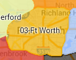 Team map area. Click image to open Waze Map Editor (WME) to this location #Slack Channel | |
| ArlenBystander(5) [PM [Help]] |
03 - Ft Worth | ||
| Ctpoole(5) [PM [Help]] |
03 - Ft Worth | ||
| Helgramite(5) [PM [Help]] |
03 - Ft Worth | ||
| PhantomSoul(5) [PM [Help]] |
03 - Ft Worth | ||
| PleaseDriveFast(4) [PM [Help]] |
03 - Ft Worth | ||
| AgentW4C(3) [PM [Help]] |
03 - Ft Worth | ||
| SAR85(3) [PM [Help]] |
03 - Ft Worth | ||
| aspherical1(2) [PM [Help]] |
03 - Ft Worth | ||
| Davisnado(2) [PM [Help]] |
03 - Ft Worth | ||
| lordmogra [PM [Help]] |
03 - Ft Worth | ||
| TXEMT(6) [PM [Help]] |
04 - Dallas |  Team map area. Click image to open Waze Map Editor (WME) to this location #Slack Channel | |
| Gasparfox(5) [PM [Help]] |
04 - Dallas | ||
| qwaletee(5) [PM [Help]] |
04 - Dallas | ||
| ialangford(4) [PM [Help]] |
04 - Dallas | ||
| yb6kos(4) [PM [Help]] |
04 - Dallas | ||
| adetia(3) [PM [Help]] |
04 - Dallas | ||
| hackmycomputer(2) [PM [Help]] |
04 - Dallas | ||
| Kinematic(2) [PM [Help]] |
04 - Dallas | ||
| kkarkid(2) [PM [Help]] |
04 - Dallas | ||
| wallydury(1) [PM [Help]] |
04 - Dallas | ||
| ply8808(5) [PM [Help]] |
05 - Mid Cities |  Team map area. Click image to open Waze Map Editor (WME) to this location #Slack Channel | |
| hardian_n(4) [PM [Help]] |
05 - Mid Cities | ||
| hitfactor(4) [PM [Help]] |
05 - Mid Cities | ||
| Poncewattle(3) [PM [Help]] |
05 - Mid Cities | ||
| voludu2(3) [PM [Help]] |
05 - Mid Cities | ||
| BarfmanTheGreat(2) [PM [Help]] |
05 - Mid Cities | ||
| ComstockMine(2) [PM [Help]] |
05 - Mid Cities | ||
| Gazoo4U(2) [PM [Help]] |
05 - Mid Cities | ||
| Tomskii(2) [PM [Help]] |
05 - Mid Cities | ||
| nightshadeNOLA(1) [PM [Help]] |
05 - Mid Cities | ||
| crazycaveman(5) [PM [Help]] |
06 - North Dallas |  Team map area. Click image to open Waze Map Editor (WME) to this location #Slack Channel | |
| dbwiddis(4) [PM [Help]] |
06 - North Dallas | ||
| t0cableguy(4) [PM [Help]] |
06 - North Dallas | ||
| faromasa(3) [PM [Help]] |
06 - North Dallas | ||
| JasonN899(3) [PM [Help]] |
06 - North Dallas | ||
| Young7Up(3) [PM [Help]] |
06 - North Dallas | ||
| DustinHetzel(2) [PM [Help]] |
06 - North Dallas | ||
| frankthetankk(2) [PM [Help]] |
06 - North Dallas | ||
| restless_in_nb(2) [PM [Help]] |
06 - North Dallas | ||
| SeekingSerenity(2) [PM [Help]] |
06 - North Dallas | ||
| TwoEightZero(2) [PM [Help]] |
06 - North Dallas | ||
| MojaveCactusMonkey(5) [PM [Help]] |
07 - Lewisville |  Team map area. Click image to open Waze Map Editor (WME) to this location #Slack Channel | |
| pumrum(5) [PM [Help]] |
07 - Lewisville | ||
| SkiDooGuy(5) [PM [Help]] |
07 - Lewisville | ||
| GS-1905(3) [PM [Help]] |
07 - Lewisville | ||
| jaywazin(3) [PM [Help]] |
07 - Lewisville | ||
| john-cole(3) [PM [Help]] |
07 - Lewisville | ||
| Joyriding(3) [PM [Help]] |
07 - Lewisville | ||
| SanzClew(3) [PM [Help]] |
07 - Lewisville | ||
| whoaitspete(3) [PM [Help]] |
07 - Lewisville | ||
| DashKS(2) [PM [Help]] |
07 - Lewisville | ||
| JButz2(2) [PM [Help]] |
07 - Lewisville | ||
| Ohmanrayman(2) [PM [Help]] |
07 - Lewisville | ||
| Trotskyist(2) [PM [Help]] |
07 - Lewisville | ||
| Rivermedic(5) [PM [Help]] |
08 - Lancaster |  Team map area. Click image to open Waze Map Editor (WME) to this location #Slack Channel | |
| coontex(4) [PM [Help]] |
08 - Lancaster | ||
| HuckD(4) [PM [Help]] |
08 - Lancaster | ||
| okladriver(3) [PM [Help]] |
08 - Lancaster | ||
| triage685(3) [PM [Help]] |
08 - Lancaster | ||
| banchormin(2) [PM [Help]] |
08 - Lancaster | ||
| DorahaMandi(2) [PM [Help]] |
08 - Lancaster | ||
| Rooksie(2) [PM [Help]] |
08 - Lancaster | ||
| UberGenius(2) [PM [Help]] |
08 - Lancaster | ||
| kyhtak(1) [PM [Help]] |
08 - Lancaster | ||
| manoeuvre(5) [PM [Help]] |
09 - Mesquite |  Team map area. Click image to open Waze Map Editor (WME) to this location #Slack Channel | |
| dmcrandall(4) [PM [Help]] |
09 - Mesquite | ||
| KuniaKid(4) [PM [Help]] |
09 - Mesquite | ||
| shadoh(4) [PM [Help]] |
09 - Mesquite | ||
| jbrianj(3) [PM [Help]] |
09 - Mesquite | ||
| qazxcvbnmm(3) [PM [Help]] |
09 - Mesquite | ||
| emdesigns(2) [PM [Help]] |
09 - Mesquite | ||
| kjg53(2) [PM [Help]] |
09 - Mesquite | ||
| Raiden38(2) [PM [Help]] |
09 - Mesquite | ||
| redspawn2k2(2) [PM [Help]] |
09 - Mesquite | ||
| orbitc(6) [PM [Help]] |
10 - Keller | 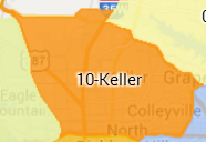 Team map area. Click image to open Waze Map Editor (WME) to this location #Slack Channel | |
| Machete808(5) [PM [Help]] |
10 - Keller | ||
| Jakflash(4) [PM [Help]] |
10 - Keller | ||
| ulle2(4) [PM [Help]] |
10 - Keller | ||
| OSUBigToe(3) [PM [Help]] |
10 - Keller | ||
| poweruser10(3) [PM [Help]] |
10 - Keller | ||
| e-sarge(2) [PM [Help]] |
10 - Keller | ||
| jr1982jr(2) [PM [Help]] |
10 - Keller | ||
| JustinS83(2) [PM [Help]] |
10 - Keller | ||
| mudge42(2) [PM [Help]] |
10 - Keller | ||
| spedracr(2) [PM [Help]] |
10 - Keller | ||
| karlcr9911(5) [PM [Help]] |
11 - Weatherford | 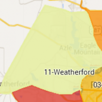 Team map area. Click image to open Waze Map Editor (WME) to this location #Slack Channel | |
| Olestas(5) [PM [Help]] |
11 - Weatherford | ||
| FzNk(4) [PM [Help]] |
11 - Weatherford | ||
| iamrioo(4) [PM [Help]] |
11 - Weatherford | ||
| Bluediemond(3) [PM [Help]] |
11 - Weatherford | ||
| kwrigh01(3) [PM [Help]] |
11 - Weatherford | ||
| autenil(2) [PM [Help]] |
11 - Weatherford | ||
| Doryphore_(2) [PM [Help]] |
11 - Weatherford | ||
| gunnargsd(2) [PM [Help]] |
11 - Weatherford | ||
| mkovnick(2) [PM [Help]] |
11 - Weatherford | ||