AnorestesX (talk | contribs) |
AnorestesX (talk | contribs) No edit summary |
||
| Line 3: | Line 3: | ||
All segments within an incorporated city or village should use the city or village name as the primary on all segments within city limits. | All segments within an incorporated city or village should use the city or village name as the primary on all segments within city limits. | ||
* The [https://greasyfork.org/en/scripts/40837-wme-cities-overlay WME Cities Overlay] script will place an overlay of city, village, and CDP boundaries on the map. Note that it does not distinguish between the types, so check to see whether a highlighted area is a city or CDP before naming. | *The [https://greasyfork.org/en/scripts/40837-wme-cities-overlay WME Cities Overlay] script will place an overlay of city, village, and CDP boundaries on the map. Note that it does not distinguish between the types, so check to see whether a highlighted area is a city or CDP before naming. | ||
All segments within a township should use the township name as primary except when meeting the CDP criteria outlined below. | All segments within a township should use the township name as primary except when meeting the CDP criteria outlined below. | ||
| Line 11: | Line 11: | ||
'''Exceptions''': Freeways and numbered State Highways should be named as found in [https://wazeopedia.waze.com/wiki/USA/Michigan#State_Numbered_Highway_Naming State Numbered Highway Naming]. | '''Exceptions''': Freeways and numbered State Highways should be named as found in [https://wazeopedia.waze.com/wiki/USA/Michigan#State_Numbered_Highway_Naming State Numbered Highway Naming]. | ||
==== CDPs (Census Designated Places): ==== | ====CDPs (Census Designated Places):==== | ||
CDPs are populated areas that generally include one officially designated but currently unincorporated community, for which the CDP is named. In some cases, these communities should be used as the primary name, based on the following criteria: | CDPs are populated areas that generally include one officially designated but currently unincorporated community, for which the CDP is named. In some cases, these communities should be used as the primary name, based on the following criteria: | ||
#If a CDP has a post office and is used for addressing within the area, it should be used as the primary name within the boundaries of the CDP. Any additional USPS/ZIP cities recognized in parts of the CDP should be added as alt city names. | #If a CDP has a post office and is used for addressing within the area, it should be used as the primary name within the boundaries of the CDP. Any additional USPS/ZIP cities recognized in parts of the CDP should be added as alt city names. | ||
#If a CDP meets at least 3 of the following 6 points, including Addressing and Local Usage, it should be used as the primary city name. | #If a CDP meets at least 3 of the following 6 points, including Addressing and Local Usage, it should be used as the primary city name. | ||
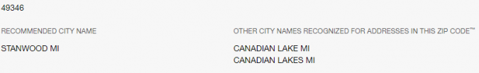
##'''Addressing''': Does the USPS recognize the CDP name for addressing as an alternate usage to the township name? | ##'''Addressing''': Does the USPS recognize the CDP name for addressing as an alternate usage to the township name? Use the [https://tools.usps.com/zip-code-lookup.htm?byaddress USPS ZIP Code Lookup] tool to check several addresses.[[File:CDP Alts MI.PNG|alt=Alternate CDP Zip Codes recognized by USPS|none|thumb|675x675px]] | ||
##'''Local Usage''': If possible, determine if the name is used locally to refer to the area. Is it generally used to refer to the area more than the Townships in which it is located? Is the name used in businesses and/or religious centers within the area? Is the name used in real estate listings for the area? | ##'''Local Usage''': If possible, determine if the name is used locally to refer to the area. Is it generally used to refer to the area more than the Townships in which it is located? Is the name used in businesses and/or religious centers within the area? Is the name used in real estate listings for the area? | ||
##'''Schools''': | ##'''Schools''': | ||
Revision as of 14:58, 19 March 2020
City Names on Segments
All segments within an incorporated city or village should use the city or village name as the primary on all segments within city limits.
- The WME Cities Overlay script will place an overlay of city, village, and CDP boundaries on the map. Note that it does not distinguish between the types, so check to see whether a highlighted area is a city or CDP before naming.
All segments within a township should use the township name as primary except when meeting the CDP criteria outlined below.
All USPS ZIP cities that differ from the primary name should be added for all names on all applicable segments. When a segment is on the boundary between two ZIP cities, add both. The WME US Government Boundaries script will allow you to see where different ZIP codes are used, and allows you to highlight postal routes to see where ZIP city names are used.
Exceptions: Freeways and numbered State Highways should be named as found in State Numbered Highway Naming.
CDPs (Census Designated Places):
CDPs are populated areas that generally include one officially designated but currently unincorporated community, for which the CDP is named. In some cases, these communities should be used as the primary name, based on the following criteria:
- If a CDP has a post office and is used for addressing within the area, it should be used as the primary name within the boundaries of the CDP. Any additional USPS/ZIP cities recognized in parts of the CDP should be added as alt city names.
- If a CDP meets at least 3 of the following 6 points, including Addressing and Local Usage, it should be used as the primary city name.
- Addressing: Does the USPS recognize the CDP name for addressing as an alternate usage to the township name? Use the USPS ZIP Code Lookup tool to check several addresses.
- Local Usage: If possible, determine if the name is used locally to refer to the area. Is it generally used to refer to the area more than the Townships in which it is located? Is the name used in businesses and/or religious centers within the area? Is the name used in real estate listings for the area?
- Schools:
- Does the CDP have its own school district?
- If there is no school district, is the CDP name used on a school within the CDP?
- Is the CDP a place of historical significance, with documented usage of the CDP name to refer to the area?
- Does the CDP have its name on official signage in the area (i.e. highway or freeway exit signs, roadside signage of "Entering [CDP]" or "Welcome to [CDP]")
- Is there an association or organization associated with promoting the CDP as a destination for travel, shopping, or residence? (i.e. https://canadianlakes.org)
- Addressing: Does the USPS recognize the CDP name for addressing as an alternate usage to the township name? Use the USPS ZIP Code Lookup tool to check several addresses.

Within CDPs used as primary cities, all segments should have the recognized USPS name as an alternate city (where different from the CDP name).