m (Copying text of wiki page for coparison with the "Minnesota/Special roads/Main" page) |
m (Copying text of wiki page for coparison with the "Tennessee/Speed Limit Mapraid" page) |
||
| Line 1: | Line 1: | ||
'''This page is still under construction, but will be ready soon!''' | |||
{{mbox|type=warning|text= | |||
{{Mapraid dates | |||
|raidname=TN Speed Limit Mapraid 2016 | |||
|formlink=//docs.google.com/forms/d/e/1FAIpQLScrKqWsXSARTPjEiS0t2tI2Rom3wRATQp1ajonhmTQMXe3aNw/viewform?c=0&w=1 | |||
|endreg=2016-09-09T2100 | |||
|startraid=2016-09-23T2100 | |||
|endraid=2016-10-03T2100}} | |||
}}<!-- | |||
The timed statement will automatically change if you put in the correct date/ UTC times. | |||
Remove the "under construction" notice when the page is ready to be read. | |||
--> | |||
<!-- | |||
Put the mapraid meme here. Something like: | |||
[[File:Mapraid JerseyShore meme3.jpg|frameless|550px|center]] | |||
<div style="width:550px;height:200px; margin-left:auto; margin-right:auto;border: 1px solid black;">Placeholder for mapraid meme</div> | |||
--> | |||
The '''Tennessee Speed Limit Mapraid''' | |||
will be '''23 September''' through '''3 October 2016'''. | |||
The participants will be divided into several | |||
groups, one for each section of the map. Each group will have both local and senior editors, one of which will be the "Group leader" - listed in blue below. Please direct all questions to your group leaders. The raid hosts will be available across all areas for added support. | |||
== Goals == | |||
# The primary goal of this mapraid is to set speed limits on {{Minor Highway}} and {{Primary Street}} segments throughout the state of Tennessee. Freeways and Major Highways should already have 100% of speed limits set, but if you come across one that is incorrect please bring it to your group leader's attention. | |||
# Roads with the {{Street}} type are also within the scope of the raid, but are considered low priority and editors should not expend significant time on them unless associated with an update request. Mass editing of speed limits on streets within urban areas based on local laws and regulations is discouraged during the raid. | |||
# Many minor Highways are state routes that need to have their names properly formatted (see below for details). Doing so is encouraged if this can be easily done when setting speed limits. | |||
# In light of the fact that many rural areas in Tennessee have significant amounts of basemap, please also make basic common-sense edits as you work on the mapraid goals -- fix bad turns and other obviously wrong information on the segments you are editing, but keep focused on the mapraid goals. If you see bigger problems that can be addressed later, or if fixing these issues would significantly impede progress on the other three goals, contact your group leader or[[File:Google form icon.PNG|frameless|15px|link=//docs.google.com/forms/d/e/1FAIpQLSffylnoHWzXgZV4PbZ5A0d16sUigAxwOVFvmidLahfF56_Gtg/viewform?c=0&w=1]][//docs.google.com/forms/d/e/1FAIpQLSffylnoHWzXgZV4PbZ5A0d16sUigAxwOVFvmidLahfF56_Gtg/viewform?c=0&w=1 record it in this form]. | |||
== | ==Hosts== | ||
(table here) | |||
== Communication == | |||
When you are editing in the raid area, please [[Waze_Map_Editor/Chat#Visible.2FInvisible|set yourself visible]] and enable the [[Map_Editor_Interface_and_Controls#Live_Users|Live Users]] layer. We will use [http://wazeusa.slack.com/messages/general Slack Channels] If you are not already part of the WazeUSA slack team, please look for your invitation to slack after mapraid registrations are processed. If you have trouble getting into the slack team or your group channel, please reach out to one of the MapRaid organizers. | |||
You can also use WME chat. The [http://www.waze.com/forum/viewtopic.php?f=819&t=95038 WME Chat addon] is recommended. | |||
==== | == Groups == | ||
(cool map widget goes here) | |||
[[File: | ==Important / Mapraid guidelines== | ||
[[File:Choose imperial units.png|thumb|right]]Please read the entire MapRaid wiki and familiarize yourself with the guidance on the [[Tennessee|Tennessee]] wiki page. If you are still uncertain what to do about something you see on the map, please ask your group leader '''Thank You for your help with the map.''' | |||
===Speed Limit Guidelines=== | |||
Use Waze Street View to find Speed Limit Signs. You may also get information from local drivers. You may use information from local ordinances posted on county or city websites. Do not rely on predicted speeds (with "verified" check box). | |||
Please set your WME preferences to '''imperial''' and enter speed limits in miles per hour. | |||
If | [[File:SpeedLimitReminders.png|frameless|right|400px]]Some segments have unverified speed limits. These speed limits were predicted by Waze. We must check each unverified speed limit. If it is correct, we can use the "Verified" check box. If it is not correct, we must replace the speed limit value. | ||
Tennessee follows the [[Speed_limits/USA|US guideline]] for speed limits, with a few exceptions listed below. | |||
==== | ====Summary of National Guidelines==== | ||
<div style="float:right;">[[File:Speed_Limit_70.png|50px|thumb|Right|Regulatory<br/>Yes]]<br/>[[File:Advisory Speed Plaque.png|50px|thumb|Advisory<br/>No]]</div> | |||
*Only map speeds found on '''regulatory''' white rectangular signs with black lettering. | |||
* Do not map '''advisory''' speed limits (generally an orange or amber rectangular sign with black lettering). | |||
* Where there are variable speed limits, map only the speed limit which is in effect most of the time during daylight hours (most hours of the day, days of the week). | |||
* Do not map special speed limits for special vehicles. Waze only supports speed limits for private passenger cars. | |||
* Where the speed limit changes, make it change in the map. A new junction may need to be added, but '''do not add a new junction for a speed limit if it will be within 200 feet of an existing junction.''' | |||
====Tennessee Specific Guidelines==== | |||
[ | According to Tennessee Code Annotated [http://law.justia.com/codes/tennessee/2010/title-55/chapter-8/55-8-152 55-8-152], the following '''maximum''' speed limits apply in Tennessee, with individual counties and municipalities setting lower speeds on individual roads as needed: | ||
* Interstates and limited access freeways (urban and rural): 70 MPH | |||
* Divided highways: 65 MPH | |||
* Undivided and two-lane roads: 55 MPH | |||
* Residential streets: 30 MPH | |||
Do NOT use the above to set speed limits on roads! However, if a UR reports a speed limit higher than one of those listed above, the report should be treated with skepticism. | |||
In addition, many counties and municipalities have enacted ordinances that establish default speeds for certain road classes. Use these data only as a last resort if you have exhausted all other options, and are able to confirm the absence of signage in street view. Even so, do not use this information to mass edit speed limits onto neighborhood streets, but instead focus on Primary Streets and above. | |||
'''DO NOT''' map the following speed limits: | |||
* Construction zones - contact a state or area manager instead | |||
* Variable speed limits based on digital signs - these can be found on several freeways | |||
* School zones or other time-based speed limits - map to the maximum speed | |||
===Base Map Areas=== | |||
There are still many areas in Tennessee which have not been touched by editors since the "base map" was imported in 2009. Only touch these areas if it is necessary to reach the objectives of this mapraid. If no information is available for setting Speed Limits, do not fix these parts of the map. These areas will be addressed at a later time. | |||
* Before setting speed limits on a segment, set the road direction correctly and correct all turns and other obviously incorrect information. | |||
** Please use the TDOT FC Maps (see link on the TN wiki page) to determine road numbers and format (SR-xxx or TN-xxx). | |||
** The FC maps list a large number of roads that had classifications upgraded in summer 2016. These roads are currently mapped as streets in Waze, but will be upgraded to Primary Street. Please do not fix these roads unless ALL other mapraid goals have been met in your area, as these will be addressed after the raid. | |||
* If roads are very bad and very difficult to fix, you may report the problem to your group leader. | |||
=== Edit Quality and Mass Editing === | |||
You are responsible for every edit you make, whether you make it by hand or use a script. Every edit you make should meet the goals of this mapraid AND make a noticeable improvement to the map. Do not make edits simply to gain points without improving the map. If a segment is "good enough" for the waze map, do not edit it. | |||
If it looks like you are making unnecessary edits or hunting for points, you may be banned from this mapraid and from future mapraids. In addition, Waze will throttle your edits and points if you use scripts excessively. | |||
Again, DO NOT mass edit speed limits onto neighborhood streets in urban/suburban areas. | |||
=== | === Update Requests (URs) === | ||
Some editors have made URs about speed limits they have seen on the road. These all contain the string "mph" or are tagged with [WSLM]. If you can find these URs, you can use them to help you set the correct speed limit on that segment. | |||
Do not just update the speed limit on one segment where the UR was and close the UR. Do your research and update the speed limit on that whole section of road where the user has driven. Additionally, add any speed limits on any easily correctable segments such as connecting roads with visible speed limit signs. After all of that has been completed, please follow correct procedure with closing speed limit URs with appropriate closing comments. If you have concerns about one that needs to be closed, please let your group leader know. | |||
Other types of URs are not a focus of this mapraid. If you spot a big problem which should be addressed, please let a group leader know. | |||
=== Road Types, Names, and Functional Classification (FC) === | |||
Road type classification is not a focus of this map raid. Freeways, Major Highways, and minor highways should already be classified correctly, while Primary Streets will be addressed after the raid. If you see and easily-fixable problem on the segments you are editing for speed limits, please consult with your group leader before fixing it. | |||
Road Names are not a primary focus of this map raid, but if you see an easily-fixable problem on the segments you are already editing, please fix it. State highway names need to be in either TN-xxx or SR-xxx format as per the TDOT FC maps. If you see any large problems with road naming, please let a group leader know. | |||
If a | ===Places=== | ||
Places are not a focus of this mapraid. If you see obviously incorrect places that will cause incorrect routing or a staff locked advertisement place that is wrong, please let your group leader know. | |||
==== | ===Issues to Address after the MapRaid=== | ||
Any major issues that need to be address will be followed up by local editors after the MapRaid conclusion. Issues such as city name merging, large scale naming (primary or alt), etc, will be handled after the fact. Remember, the concentration is speed limits and lock levels. | |||
==Mapping Resources== | |||
Use Street View and Satellite View from within Waze and the sources listed below. Do not use any unauthorized online mapping resources and if you have any questions on legitimacy of a resource, please talk to you group leader. | |||
{{red|Warning: If you copy information from unauthorized sources, you may be removed from this mapraid. Also, every segment or place you edited might be removed from the map. Copying information from copyrighted sources is illegal!}} | |||
==== | ===TN Mapping Resources=== | ||
* [http://www.tn.gov/tdot/topic/maps-functional-classification Long Range Planning Functional Classification Maps] | |||
* Several counties and cities have their own GIS sources. Please see the main page of the TN wiki for links. | |||
== Tools for this mapraid == | |||
=== Basic References === | |||
;[[Waze Map Editor/Welcome|New editor welcome page]] | |||
;[[Waze Map Editor]] | |||
;[[Best Map Editing Practice]] | |||
;[[Editing manual]] | |||
;[[Common editing mistakes]] | |||
;[[Permalink|How to make a Permalink]]; [//www.youtube.com/watch?v=xYmU6UPCiZs YouTube] | |||
;[[WME Chat|All about using the WME Chat]] | |||
;[http://drive.google.com/file/d/0B8WbeRGWGEOjQ1BvbHFtYlJSV2pIOVdyQlgtRmJzQUtHNjRz WME Reference Sheet<sup><small><nowiki>[PDF]</nowiki></small></sup>] | |||
:a printable double-sided tri-fold quick reference guide to some of the common topics used in WME. | |||
;[[Community Plugins, Extensions and Tools]] | |||
: links and descriptions to most of the editing scripts being used. Some of these are essential to good editing, and others make the editing process much easier. WME Validator, URO+, and WME Toolbox are highly recommended. | |||
;[//www.youtube.com/watch?v=7f3GNL0_La0 How to Install a Chrome Extension (YouTube)] | |||
=== Basic Scripts and Extensions === | |||
<!--;[//greasyfork.org/en/scripts/20147-wme-nc-mapraid-overlay Mapraid Overlay] | |||
:This script shows the boundaries of each mapraid group area. It may be useful to you if you have editable area in more than one mapraid group area.--> | |||
;[//www.waze.com/forum/viewtopic.php?t=40705#p369457 WME Color Highlights] | |||
: Install [//chrome.google.com/webstore/detail/wme-color-highlights/ijnldkoicbhinlgnoigchihmegdjobjc Chrome Extension] or [//greasyfork.org/scripts/3206-wme-color-highlights tampermonkey / greasemonkey script] | |||
: Check the option for "No Speed Limit" and Uncheck the other highlight options. | |||
: Segments with no speed limit or unverified speed limit will be highlighted orange. | |||
;[//greasyfork.org/scripts/13774-wme-speedhelper Speed Limit Helper] | |||
: Makes it easier to add the correct speed limits. | |||
: tampermonkey/greasemonkey required | |||
;[//greasyfork.org/en/scripts/12402-wme-speeds WME Speeds] | |||
:Adds colours to road segments to show their speeds. | |||
: tampermonkey/greasemonkey required | |||
;[//greasyfork.org/en/scripts/17112-wme-street-view-availability WME Street View Availability] | |||
:WME userscript that shows where you can expect to find Street View imagery. The information provided is quite basic, but this is all that is readily available to show. | |||
: tampermonkey/greasemonkey required | |||
;[//greasyfork.org/en/scripts/2103-wme-chat-addon WME Chat Addon] | |||
:a script that improves the WME chat interface. For a list of all the features check the thread [http://www.waze.com/forum/viewtopic.php?f=819&t=95038 here] -- Tampermonkey/Greasemonkey required | |||
===Advanced Scripts and Extensions=== | |||
; [//greasyfork.org/scripts/17087-wme-context-menu WME Context Menu] | |||
: Right-click pop-up menu that works with speed limit helper. | |||
: requires tampermonkey / greasemonkey. Works best alongside Speed Limit Helper. | |||
: Read more at [//www.waze.com/forum/viewtopic.php?f=819&t=178371 WME Context Menu][[File:URO+ MPH.PNG|thumb|right|100px|URO+ settings to find speed limit URs]] | |||
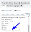
;[//greasyfork.org/en/scripts/1952-uroverview-plus-uro Search for mph URs using URO+] | |||
:In the "misc" tab, scroll down to custom markers, choose the last one, and type "mph" in the text box. | |||
:Speed Limit URs and elevation URs are the only ones we should be working with during this mapraid. | |||
;WME Toolbox | |||
:Now with a speed limit highlight option. | |||
:This script has lots of ways to help remove unnecessary nodes, cut segments, locate "Soft Nodes", or nodes with undefined directions. | |||
:* Install for [http://chrome.google.com/webstore/detail/wme-toolbox/ihebciailciabdiknfomleeccodkdejn?utm_source=chrome-app-launcher-info-dialog Chrome] | |||
:* Install for [http://gitlab.com/doctorkb/wme-toolbox-public/raw/master/Dist/Firefox/wmetoolbox.xpi Firefox]. | |||
;[http://www.waze.com/forum/viewtopic.php?t=76488 Validator] | |||
:highlights issues on the map and can generate a very detailed report with U.S. wiki references and possible solutions. | |||
:* [http://chrome.google.com/webstore/detail/wme-validator/baojhpeknpmkhplkcnpdcficcaaniaih For Chrome Browser] | |||
:* [http://greasyfork.org/scripts/1571-wme-validator GreasyFork.org for Firefox] -- Tampermonkey/Greasemonkey required | |||
== Mapraid edit lists == | |||
Spreadsheets and forms are being used to streamline management of various group efforts and track important edits. Below you can find links to use these these forms, sheets, and see the lists. | |||
== Results == | |||
{{Mbox | |||
| type = speculation | |||
| text = Check back here after the raid is completed to see the results and achievements}} | |||
== MapRaid Promotions == | |||
Some editors really let their bright side out, and let their community skills shine. This is even more evident in a concerted group effort with high-density editing like a MapRaid!. Editors of all ranks working closely with each other and the Champs, really lets us everyone get to know each other, and allows certain editors to be recognized for their skills and effort. | |||
When the Champs see someone consistently editing well, interacting well with the community, and knowledgeable of the various details from the Wiki, they can issue promotions. This can be anything from the size of a managed area, to a rank increase, or even a new role. | |||
{{mbox | {{mbox | ||
| type = | | type = speculation | ||
| text = | | text = Watch here for results of promotions during and after the raid. | ||
}} | }} | ||
[[Category:Mapraid]] | |||
Revision as of 17:35, 2 September 2016
This page is still under construction, but will be ready soon!
| TN Speed Limit Mapraid 2016 ended on 03 Oct 2016 21:00:00 UTC. Please check back here for results and check the Mapraid Forum for mapraid announcements. |
The Tennessee Speed Limit Mapraid will be 23 September through 3 October 2016. The participants will be divided into several groups, one for each section of the map. Each group will have both local and senior editors, one of which will be the "Group leader" - listed in blue below. Please direct all questions to your group leaders. The raid hosts will be available across all areas for added support.
Goals
- The primary goal of this mapraid is to set speed limits on Minor Highway and Primary Street segments throughout the state of Tennessee. Freeways and Major Highways should already have 100% of speed limits set, but if you come across one that is incorrect please bring it to your group leader's attention.
- Roads with the Street type are also within the scope of the raid, but are considered low priority and editors should not expend significant time on them unless associated with an update request. Mass editing of speed limits on streets within urban areas based on local laws and regulations is discouraged during the raid.
- Many minor Highways are state routes that need to have their names properly formatted (see below for details). Doing so is encouraged if this can be easily done when setting speed limits.
- In light of the fact that many rural areas in Tennessee have significant amounts of basemap, please also make basic common-sense edits as you work on the mapraid goals -- fix bad turns and other obviously wrong information on the segments you are editing, but keep focused on the mapraid goals. If you see bigger problems that can be addressed later, or if fixing these issues would significantly impede progress on the other three goals, contact your group leader or
 record it in this form.
Hosts
(table here)
Communication
When you are editing in the raid area, please set yourself visible and enable the Live Users layer. We will use Slack Channels If you are not already part of the WazeUSA slack team, please look for your invitation to slack after mapraid registrations are processed. If you have trouble getting into the slack team or your group channel, please reach out to one of the MapRaid organizers.
You can also use WME chat. The WME Chat addon is recommended.
Groups
(cool map widget goes here)
Important / Mapraid guidelines

Please read the entire MapRaid wiki and familiarize yourself with the guidance on the Tennessee wiki page. If you are still uncertain what to do about something you see on the map, please ask your group leader Thank You for your help with the map.
Speed Limit Guidelines
Use Waze Street View to find Speed Limit Signs. You may also get information from local drivers. You may use information from local ordinances posted on county or city websites. Do not rely on predicted speeds (with "verified" check box).
Please set your WME preferences to imperial and enter speed limits in miles per hour.

Some segments have unverified speed limits. These speed limits were predicted by Waze. We must check each unverified speed limit. If it is correct, we can use the "Verified" check box. If it is not correct, we must replace the speed limit value.
Tennessee follows the US guideline for speed limits, with a few exceptions listed below.
Summary of National Guidelines

Yes

No
- Only map speeds found on regulatory white rectangular signs with black lettering.
- Do not map advisory speed limits (generally an orange or amber rectangular sign with black lettering).
- Where there are variable speed limits, map only the speed limit which is in effect most of the time during daylight hours (most hours of the day, days of the week).
- Do not map special speed limits for special vehicles. Waze only supports speed limits for private passenger cars.
- Where the speed limit changes, make it change in the map. A new junction may need to be added, but do not add a new junction for a speed limit if it will be within 200 feet of an existing junction.
Tennessee Specific Guidelines
According to Tennessee Code Annotated 55-8-152, the following maximum speed limits apply in Tennessee, with individual counties and municipalities setting lower speeds on individual roads as needed:
- Interstates and limited access freeways (urban and rural): 70 MPH
- Divided highways: 65 MPH
- Undivided and two-lane roads: 55 MPH
- Residential streets: 30 MPH
Do NOT use the above to set speed limits on roads! However, if a UR reports a speed limit higher than one of those listed above, the report should be treated with skepticism.
In addition, many counties and municipalities have enacted ordinances that establish default speeds for certain road classes. Use these data only as a last resort if you have exhausted all other options, and are able to confirm the absence of signage in street view. Even so, do not use this information to mass edit speed limits onto neighborhood streets, but instead focus on Primary Streets and above.
DO NOT map the following speed limits:
- Construction zones - contact a state or area manager instead
- Variable speed limits based on digital signs - these can be found on several freeways
- School zones or other time-based speed limits - map to the maximum speed
Base Map Areas
There are still many areas in Tennessee which have not been touched by editors since the "base map" was imported in 2009. Only touch these areas if it is necessary to reach the objectives of this mapraid. If no information is available for setting Speed Limits, do not fix these parts of the map. These areas will be addressed at a later time.
- Before setting speed limits on a segment, set the road direction correctly and correct all turns and other obviously incorrect information.
- Please use the TDOT FC Maps (see link on the TN wiki page) to determine road numbers and format (SR-xxx or TN-xxx).
- The FC maps list a large number of roads that had classifications upgraded in summer 2016. These roads are currently mapped as streets in Waze, but will be upgraded to Primary Street. Please do not fix these roads unless ALL other mapraid goals have been met in your area, as these will be addressed after the raid.
- If roads are very bad and very difficult to fix, you may report the problem to your group leader.
Edit Quality and Mass Editing
You are responsible for every edit you make, whether you make it by hand or use a script. Every edit you make should meet the goals of this mapraid AND make a noticeable improvement to the map. Do not make edits simply to gain points without improving the map. If a segment is "good enough" for the waze map, do not edit it.
If it looks like you are making unnecessary edits or hunting for points, you may be banned from this mapraid and from future mapraids. In addition, Waze will throttle your edits and points if you use scripts excessively.
Again, DO NOT mass edit speed limits onto neighborhood streets in urban/suburban areas.
Update Requests (URs)
Some editors have made URs about speed limits they have seen on the road. These all contain the string "mph" or are tagged with [WSLM]. If you can find these URs, you can use them to help you set the correct speed limit on that segment.
Do not just update the speed limit on one segment where the UR was and close the UR. Do your research and update the speed limit on that whole section of road where the user has driven. Additionally, add any speed limits on any easily correctable segments such as connecting roads with visible speed limit signs. After all of that has been completed, please follow correct procedure with closing speed limit URs with appropriate closing comments. If you have concerns about one that needs to be closed, please let your group leader know.
Other types of URs are not a focus of this mapraid. If you spot a big problem which should be addressed, please let a group leader know.
Road Types, Names, and Functional Classification (FC)
Road type classification is not a focus of this map raid. Freeways, Major Highways, and minor highways should already be classified correctly, while Primary Streets will be addressed after the raid. If you see and easily-fixable problem on the segments you are editing for speed limits, please consult with your group leader before fixing it.
Road Names are not a primary focus of this map raid, but if you see an easily-fixable problem on the segments you are already editing, please fix it. State highway names need to be in either TN-xxx or SR-xxx format as per the TDOT FC maps. If you see any large problems with road naming, please let a group leader know.
Places
Places are not a focus of this mapraid. If you see obviously incorrect places that will cause incorrect routing or a staff locked advertisement place that is wrong, please let your group leader know.
Issues to Address after the MapRaid
Any major issues that need to be address will be followed up by local editors after the MapRaid conclusion. Issues such as city name merging, large scale naming (primary or alt), etc, will be handled after the fact. Remember, the concentration is speed limits and lock levels.
Mapping Resources
Use Street View and Satellite View from within Waze and the sources listed below. Do not use any unauthorized online mapping resources and if you have any questions on legitimacy of a resource, please talk to you group leader.
Warning: If you copy information from unauthorized sources, you may be removed from this mapraid. Also, every segment or place you edited might be removed from the map. Copying information from copyrighted sources is illegal!
TN Mapping Resources
- Long Range Planning Functional Classification Maps
- Several counties and cities have their own GIS sources. Please see the main page of the TN wiki for links.
Tools for this mapraid
Basic References
- New editor welcome page
- Waze Map Editor
- Best Map Editing Practice
- Editing manual
- Common editing mistakes
- How to make a Permalink; YouTube
- All about using the WME Chat
- WME Reference Sheet[PDF]
- a printable double-sided tri-fold quick reference guide to some of the common topics used in WME.
- Community Plugins, Extensions and Tools
- links and descriptions to most of the editing scripts being used. Some of these are essential to good editing, and others make the editing process much easier. WME Validator, URO+, and WME Toolbox are highly recommended.
- How to Install a Chrome Extension (YouTube)
Basic Scripts and Extensions
- WME Color Highlights
- Install Chrome Extension or tampermonkey / greasemonkey script
- Check the option for "No Speed Limit" and Uncheck the other highlight options.
- Segments with no speed limit or unverified speed limit will be highlighted orange.
- Speed Limit Helper
- Makes it easier to add the correct speed limits.
- tampermonkey/greasemonkey required
- WME Speeds
- Adds colours to road segments to show their speeds.
- tampermonkey/greasemonkey required
- WME Street View Availability
- WME userscript that shows where you can expect to find Street View imagery. The information provided is quite basic, but this is all that is readily available to show.
- tampermonkey/greasemonkey required
- WME Chat Addon
- a script that improves the WME chat interface. For a list of all the features check the thread here -- Tampermonkey/Greasemonkey required
Advanced Scripts and Extensions
- WME Context Menu
- Right-click pop-up menu that works with speed limit helper.
- requires tampermonkey / greasemonkey. Works best alongside Speed Limit Helper.
- Read more at WME Context Menu
URO+ settings to find speed limit URs - Search for mph URs using URO+
- In the "misc" tab, scroll down to custom markers, choose the last one, and type "mph" in the text box.
- Speed Limit URs and elevation URs are the only ones we should be working with during this mapraid.
- WME Toolbox
- Now with a speed limit highlight option.
- This script has lots of ways to help remove unnecessary nodes, cut segments, locate "Soft Nodes", or nodes with undefined directions.

- Validator
- highlights issues on the map and can generate a very detailed report with U.S. wiki references and possible solutions.
- For Chrome Browser
- GreasyFork.org for Firefox -- Tampermonkey/Greasemonkey required
Mapraid edit lists
Spreadsheets and forms are being used to streamline management of various group efforts and track important edits. Below you can find links to use these these forms, sheets, and see the lists.
Results
| Check back here after the raid is completed to see the results and achievements |
MapRaid Promotions
Some editors really let their bright side out, and let their community skills shine. This is even more evident in a concerted group effort with high-density editing like a MapRaid!. Editors of all ranks working closely with each other and the Champs, really lets us everyone get to know each other, and allows certain editors to be recognized for their skills and effort.
When the Champs see someone consistently editing well, interacting well with the community, and knowledgeable of the various details from the Wiki, they can issue promotions. This can be anything from the size of a managed area, to a rank increase, or even a new role.
| Watch here for results of promotions during and after the raid. |