Tunisiano18 (talk | contribs) (Created page with "Lane Guidance") |
WTranlatebot (talk | contribs) (Updating to match new version of source page) |
||
| (7 intermediate revisions by 3 users not shown) | |||
| Line 1: | Line 1: | ||
{{TopLine}} | {{TopLine}} | ||
<languages /> | <languages /> | ||
La possibilité de guider l'usager par bande, un expérience de conduite plus claire et plus fluide pour le conducteur. | |||
<br /> | <br /> | ||
Quand vous éditez, attention au différents types de jonctions. | |||
Si vous ne savez pas ajouter de bandes,''' plutôt que de hacker la carte''' ou de contourner le problème veuillez ajouter un feedback dans le [https://docs.google.com/spreadsheets/d/1sQYbeTZK0cGFkcFAbYRj7DqHINBNcVaQQLhkq1Eknso/edit spreadsheet], choisissez le type de feedback, et expliquez la raison. | |||
<br /> | <br /> | ||
= | <span id="How_does_it_look_in_the_app?"></span> | ||
Comment cela se présente-t-il dans l'application ? | |||
<div lang="en" dir="ltr" class="mw-content-ltr"> | |||
- The next turn indication will transition to a lane guidance for streets where the lanes have been added from the Waze Map Editors community. | - The next turn indication will transition to a lane guidance for streets where the lanes have been added from the Waze Map Editors community. | ||
</div> | |||
- | - Pour les rues principales et les autoroutes mineures, cela se produira ~500m avant la jonction. Pour les autoroutes et les routes principales, il se situe à environ 1,5 km. | ||
= | <span id="Important_to_know"></span> | ||
Important à savoir | |||
=== | <span id="What_is_currently_not_supported,_but_we_are_working_on?"></span> | ||
=== Ce qui n'est pas pris en charge actuellement, mais sur lequel nous travaillons === | |||
* | * Des types de jonctions plus complexes. Actuellement, nous ne supportons que les jonctions +, H et #. | ||
=== | <span id="What_is_currently_out_of_scope?"></span> | ||
=== Ce qui est actuellement hors de portée ? === | |||
* | * Les voies sur les ronds-points. | ||
* | * Voies de fusion | ||
* | * Voies sur AA, la plateforme entière est en train d'être restructurée et redessinée afin de faciliter l'ajout de fonctionnalités. | ||
* Guidage des voies sur la "route du serpent" à travers JB. | |||
* Voies réservées aux bus (et autres voies non autorisées). | |||
= | <span id="Known_issues"></span> | ||
Problèmes connus | |||
<div lang="en" dir="ltr" class="mw-content-ltr"> | |||
* Lanes are available on Carplay but are not centered, slightly aligned to the left. | * Lanes are available on Carplay but are not centered, slightly aligned to the left. | ||
* Editing segments with lane guidance, i.e: splitting them, will cause lanes data removal so make sure to add map comments where necessary. | * Editing segments with lane guidance, i.e: splitting them, will cause lanes data removal so make sure to add map comments where necessary. | ||
<br /> | <br /> | ||
</div> | |||
=== | <span id="Where_can_we_find_more_information_about_Lanes?"></span> | ||
=== Où peut-on trouver plus d'informations sur les couloirs ? === | |||
<div lang="en" dir="ltr" class="mw-content-ltr"> | |||
We created this '''[https://docs.google.com/document/d/1cXlvoKXLp9bnIp33Ito3KjmLaMqL7cWq5VDL8JBgXkg/edit#heading=h.82emqwgz41eb Lanes Knowledge Base]''' in order to help you start smoothly and have a snapshot of all the knowledge created during the alpha and beta stage. We’ll make sure to update it periodically with new content if needed. | We created this '''[https://docs.google.com/document/d/1cXlvoKXLp9bnIp33Ito3KjmLaMqL7cWq5VDL8JBgXkg/edit#heading=h.82emqwgz41eb Lanes Knowledge Base]''' in order to help you start smoothly and have a snapshot of all the knowledge created during the alpha and beta stage. We’ll make sure to update it periodically with new content if needed. | ||
<br /> | <br /> | ||
</div> | |||
== | <div lang="en" dir="ltr" class="mw-content-ltr"> | ||
== At-grade crossings == | == At-grade crossings == | ||
</div> | |||
<div lang="en" dir="ltr" class="mw-content-ltr"> | |||
[[File:At-grade crossing.jpg|right|500x500px]] | [[File:At-grade crossing.jpg|right|500x500px]] | ||
At intersections with a stop line, take all existing lanes. | At intersections with a stop line, take all existing lanes. | ||
| Line 70: | Line 68: | ||
Avoid to use at-grade connectors. See also the [https://wazeopedia.waze.com/wiki/Global/At-grade_connectors Global wiki] | Avoid to use at-grade connectors. See also the [https://wazeopedia.waze.com/wiki/Global/At-grade_connectors Global wiki] | ||
{{Clear}} | {{Clear}} | ||
</div> | |||
<div lang="en" dir="ltr" class="mw-content-ltr"> | |||
== '''H''' and '''#''' crossings == | == '''H''' and '''#''' crossings == | ||
</div> | |||
<div lang="en" dir="ltr" class="mw-content-ltr"> | |||
[[File:Heuristics.jpg|right|500px]] | [[File:Heuristics.jpg|right|500px]] | ||
</div> | |||
<div lang="en" dir="ltr" class="mw-content-ltr"> | |||
On those crossing the Lane Guidance instructions will be combined. (Heuristics) | On those crossing the Lane Guidance instructions will be combined. (Heuristics) | ||
</div> | |||
<div lang="en" dir="ltr" class="mw-content-ltr"> | |||
There are some conditions that must be taken into account. | There are some conditions that must be taken into account. | ||
* The intermediate segment must be less than 50m. | * The intermediate segment must be less than 50m. | ||
* Straight segments must be in a straight line (option for a 20° offset) | * Straight segments must be in a straight line (option for a 20° offset) | ||
* Left turn must be between 70° a 110°) You can Use "Micro Doglegs" | * Left turn must be between 70° a 110°) You can Use "Micro Doglegs" | ||
* The number of lanes entering the intersection is equal to the total number of lanes exiting the intersection (i.e., no new lanes are added in the median). | * The number of lanes entering the intersection is equal to the total number of lanes exiting the intersection (i.e., no new lanes are added or subtracted in the median). | ||
* All intermediate segments, having more than 1 allowed direction, must be configured with LG and number of lanes must not change withing that segment. | |||
</div> | |||
<div lang="en" dir="ltr" class="mw-content-ltr"> | |||
[[File:Heuristic-Angles.PNG|300px]] | [[File:Heuristic-Angles.PNG|300px]] | ||
</div> | |||
<div lang="en" dir="ltr" class="mw-content-ltr"> | |||
{{clear}} | {{clear}} | ||
</div> | |||
<div lang="en" dir="ltr" class="mw-content-ltr"> | |||
== Junction Box == | == Junction Box == | ||
</div> | |||
<div lang="en" dir="ltr" class="mw-content-ltr"> | |||
Lane Guidance can be added to segments which are part of a Junction Box just as they can be added to any other segment. All turn arrows inside a Junction Box must be green (unrestricted) in order for lane guidance to work. Use the Junction Box itself to restrict any necessary turns. | Lane Guidance can be added to segments which are part of a Junction Box just as they can be added to any other segment. All turn arrows inside a Junction Box must be green (unrestricted) in order for lane guidance to work. Use the Junction Box itself to restrict any necessary turns. | ||
</div> | |||
<div lang="en" dir="ltr" class="mw-content-ltr"> | |||
LG offers more options when applied to a segment entering a JB. This is documented in the page about the JB. | |||
</div> | |||
<div lang="en" dir="ltr" class="mw-content-ltr"> | |||
== Bus Lanes == | == Bus Lanes == | ||
</div> | |||
<div lang="en" dir="ltr" class="mw-content-ltr"> | |||
Normally bus lanes are not mapped. Except when you may use this lane on the next crossing to go Left or right. So they can only be marked with: [[File:Left.png]] [[File:Right.png]] | Normally bus lanes are not mapped. Except when you may use this lane on the next crossing to go Left or right. So they can only be marked with: [[File:Left.png]] [[File:Right.png]] | ||
</div> | |||
<div lang="en" dir="ltr" class="mw-content-ltr"> | |||
== Guidelines on when LG can be used == | |||
</div> | |||
<div lang="en" dir="ltr" class="mw-content-ltr"> | |||
With some exceptions, LG are used only on Freeway, Major Highway, Minor Highway. | |||
</div> | |||
<div lang="en" dir="ltr" class="mw-content-ltr"> | |||
In following cases, there is usually a possible confusion about which lane(s) to use, hence configure LG, unless the local situation is exceptional. | |||
</div> | |||
<div lang="en" dir="ltr" class="mw-content-ltr"> | |||
* On regular junctions where there are at least 2 lanes for 1 of the given directions. | |||
* On regular junctions where incoming lanes have a mandatory direction other than straight ahead. | |||
* On complex junctions. Example there are 2 segments on the right (first with an angle of <90° and the other one with an angle of > 90°[[File:Lanes052.png|thumb]] | |||
</div> | |||
<div lang="en" dir="ltr" class="mw-content-ltr"> | |||
== Guidelines on when '''NOT''' to use LG == | |||
</div> | |||
<div lang="en" dir="ltr" class="mw-content-ltr"> | |||
In following cases, there is generally no possible confusion about which lane(s) to use, hence do not configure LG, unless the local situation is exceptional. Our aim is indeed, to generate instructions only when they are necessary. | |||
</div> | |||
<div lang="en" dir="ltr" class="mw-content-ltr"> | |||
* On highways, for a simple 1 lane exit where the number of lanes before and after the exit remains the same. | |||
* On regular junctions where the pre-sorting lanes are rather short | |||
* On regular junctions with only 1 lane for each direction, unless some incoming lane cannot be used to continue straight ahead. | |||
</div> | |||
<div lang="en" dir="ltr" class="mw-content-ltr"> | |||
== Guidelines on when to use CS (Continue Straight) == | |||
Continue Straight lane's are not shown by default. This can be overruled. [[File:LG-CS.jpg|200px|thumb|right]] | |||
</div> | |||
<div lang="en" dir="ltr" class="mw-content-ltr"> | |||
=== view only === | |||
* If there can be confusion with another LG within the threshold distance (Freeway and Major Highway 1,5km, minor Highway 500m) before. | |||
</div> | |||
<div lang="en" dir="ltr" class="mw-content-ltr"> | |||
=== view and hear === | |||
* When some of the lanes before the junction are not anymore available after the junction | |||
{{clear}} | |||
</div> | |||
== | <div lang="en" dir="ltr" class="mw-content-ltr"> | ||
==Tools== | |||
* <b>Lane Tools</b> | |||
: [https://github.com/SkiDooGuy/WME-LaneTools/blob/master/WME-LaneTools.user.js Go to script ] And click on RAW | |||
</div> | |||
[[Category:Road attributes{{#translation:}}]] [[Category:Routing{{#translation:}}]] | <div lang="en" dir="ltr" class="mw-content-ltr"> | ||
[[Category:Road attributes{{#translation:}}]] [[Category:Routing{{#translation:}}]] | |||
</div> | |||
{{Bottomline}} | {{Bottomline}} | ||
Latest revision as of 17:15, 20 February 2024

La possibilité de guider l'usager par bande, un expérience de conduite plus claire et plus fluide pour le conducteur.
Quand vous éditez, attention au différents types de jonctions.
Si vous ne savez pas ajouter de bandes, plutôt que de hacker la carte ou de contourner le problème veuillez ajouter un feedback dans le spreadsheet, choisissez le type de feedback, et expliquez la raison.
Comment cela se présente-t-il dans l'application ?
- The next turn indication will transition to a lane guidance for streets where the lanes have been added from the Waze Map Editors community.
- Pour les rues principales et les autoroutes mineures, cela se produira ~500m avant la jonction. Pour les autoroutes et les routes principales, il se situe à environ 1,5 km.
Important à savoir
Ce qui n'est pas pris en charge actuellement, mais sur lequel nous travaillons
- Des types de jonctions plus complexes. Actuellement, nous ne supportons que les jonctions +, H et #.
Ce qui est actuellement hors de portée ?
- Les voies sur les ronds-points.
- Voies de fusion
- Voies sur AA, la plateforme entière est en train d'être restructurée et redessinée afin de faciliter l'ajout de fonctionnalités.
- Guidage des voies sur la "route du serpent" à travers JB.
- Voies réservées aux bus (et autres voies non autorisées).
Problèmes connus
- Lanes are available on Carplay but are not centered, slightly aligned to the left.
- Editing segments with lane guidance, i.e: splitting them, will cause lanes data removal so make sure to add map comments where necessary.
Où peut-on trouver plus d'informations sur les couloirs ?
We created this Lanes Knowledge Base in order to help you start smoothly and have a snapshot of all the knowledge created during the alpha and beta stage. We’ll make sure to update it periodically with new content if needed.
At-grade crossings

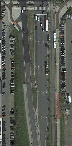
At intersections with a stop line, take all existing lanes.
In the example at the right this will give the following:
![]()
![]()
![]()
![]()
![]()
Avoid to use at-grade connectors. See also the Global wiki
H and # crossings
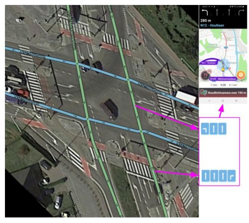
On those crossing the Lane Guidance instructions will be combined. (Heuristics)
There are some conditions that must be taken into account.
- The intermediate segment must be less than 50m.
- Straight segments must be in a straight line (option for a 20° offset)
- Left turn must be between 70° a 110°) You can Use "Micro Doglegs"
- The number of lanes entering the intersection is equal to the total number of lanes exiting the intersection (i.e., no new lanes are added or subtracted in the median).
- All intermediate segments, having more than 1 allowed direction, must be configured with LG and number of lanes must not change withing that segment.
Junction Box
Lane Guidance can be added to segments which are part of a Junction Box just as they can be added to any other segment. All turn arrows inside a Junction Box must be green (unrestricted) in order for lane guidance to work. Use the Junction Box itself to restrict any necessary turns.
LG offers more options when applied to a segment entering a JB. This is documented in the page about the JB.
Bus Lanes
Normally bus lanes are not mapped. Except when you may use this lane on the next crossing to go Left or right. So they can only be marked with: ![]()
![]()
Guidelines on when LG can be used
With some exceptions, LG are used only on Freeway, Major Highway, Minor Highway.
In following cases, there is usually a possible confusion about which lane(s) to use, hence configure LG, unless the local situation is exceptional.
- On regular junctions where there are at least 2 lanes for 1 of the given directions.
- On regular junctions where incoming lanes have a mandatory direction other than straight ahead.
- On complex junctions. Example there are 2 segments on the right (first with an angle of <90° and the other one with an angle of > 90°

Guidelines on when NOT to use LG
In following cases, there is generally no possible confusion about which lane(s) to use, hence do not configure LG, unless the local situation is exceptional. Our aim is indeed, to generate instructions only when they are necessary.
- On highways, for a simple 1 lane exit where the number of lanes before and after the exit remains the same.
- On regular junctions where the pre-sorting lanes are rather short
- On regular junctions with only 1 lane for each direction, unless some incoming lane cannot be used to continue straight ahead.
view only
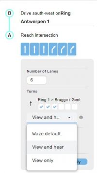
- If there can be confusion with another LG within the threshold distance (Freeway and Major Highway 1,5km, minor Highway 500m) before.
view and hear
- When some of the lanes before the junction are not anymore available after the junction
Tools
- Lane Tools
- Go to script And click on RAW

