Sin resumen de edición |
|||
| Línea 16: | Línea 16: | ||
Si el ferry no cumple con alguna de las condiciones anteriores, puede agregarse al mapa. | Si el ferry no cumple con alguna de las condiciones anteriores, puede agregarse al mapa. | ||
Si tiene alguna pregunta sobre si el ferry debe o no debe ser mapeado, contacte a | Si tiene alguna pregunta sobre si el ferry debe o no debe ser mapeado, contacte a sus Local[[Regional Coordinator| ]]Champs o publica en el [http://www.waze.com/forum/viewforum.php?f=8 forum.] | ||
== Cómo agregar == | == Cómo agregar == | ||
Revisión del 18:00 20 feb 2018

| Página principal | Quiénes Somos | Cómo Editar | Municipios de Colombia | Foro |
| Solo editores autorizados pueden realizar cambios o actualizaciones, por favor abstenerse de realizarlos, para contribuir en actualizaciones sugerirlas en Foro |
Los Ferrys son grandes embarcaciones acuáticas (embarcaciones) que transportan vehículos (y personas) desde un muelle de transbordadores a otro. Los ferries normalmente tienen salidas programadas y a menudo se ejecutan como parte del sistema de autopistas.
En algunos estados, los transbordadores son una parte clave del sistema de carreteras y son difíciles de evitar. En algunas áreas, es importante agregarlas al mapa porque a veces son la mejor opción y, en algunos casos, la única opción para llegar a un destino.
No todos los transbordadores deben ser mapeados sin embargo. Deben seguirse las siguientes pautas al considerar agregar un ferry al mapa de Waze.
Cuándo y cuándo no agregar
Los Ferrys que cumplan con 'cualquiera' 'de estas condiciones generalmente no debe' ser mapeado.
- Ferrys de pasajeros sin vehículos
- Ferrys que requieren reserva previa
- Ferrys privados no disponibles para el público en general
- Ferrys de más de dos horas de duración
Si el ferry no cumple con alguna de las condiciones anteriores, puede agregarse al mapa.
Si tiene alguna pregunta sobre si el ferry debe o no debe ser mapeado, contacte a sus Local Champs o publica en el forum.
Cómo agregar
La longitud total de la ruta del ferry y ambos puntos de atraque deben ser parte de su área editable. Puede ser necesario viajar en el ferry con Waze corriendo para agregar esa ruta a su área.
- Enciende el GPS Points Layer para ver el camino típico del ferry. Si no hay puntos de GPS visibles, puede estar bien dibujar una línea recta entre los dos muelles.
- Draw a segment de un muelle de ferry a otro siguiendo los puntos de GPS.Name and label the new segment with No City and with the road name of the ferry line. This is often the combined names of both sides of the Ferry. For example: Bainbridge Island - Seattle Ferry. The road type should match the road type on either side of ferry. Do not use Ferry, Freeway, Parking Lot, or Private Road Types. If the ferry is a part of the highway system, then it should be marked Minor or Major Highway. Be sure to set the time restrictions on the segment including the first ferry (opening time) and the last ferry (closing time).
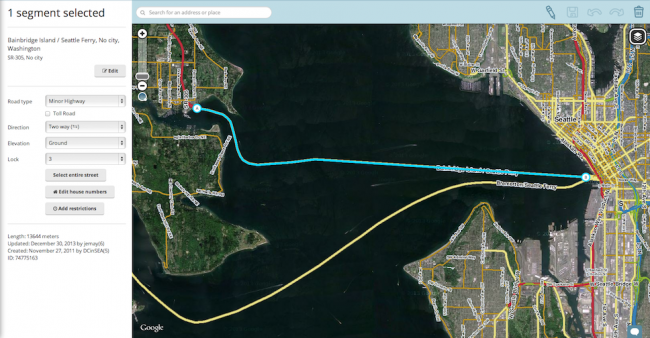
- Draw segments on both loading ramps using the same road type as the ferry. These should have the correct city name entered on each side and "Ferry Loading Ramp" in road name field for both. (Editor Note: This gives some separation from the ferry and the ferry's slow waiting lines, enabling better routing.)
- Draw a one-way segment connecting the loading ramp segment to the main road on both sides using the same road type as the ferry. Label it with the correct city name on each side and No Name in name field. If ferry has multiple exit routes and clear signs then you can label the exit road with the standard "to: X" and "to: Y". Example "to: Seattle" and "to: I-90 / I-5".
- Draw another one-way segment connecting the main roads to the loading ramp segment on both sides using the same road type as the ferry. Mark is as a toll road if it has a fee in the direction of this segment. It should be labeled with correct city name on each side and "to Bainbridge Island - Seattle Ferry". (Editor Note: some ferries charge riders going one direction and not the other. You commonly see this when ferries are going to an Island where the ferry is the only access, then the ferry going to the island is toll road and ferry going to main land is not tolled. Splitting exit and entrance ramps enable this flexibility).

Examples of properly mapped ferry docks


Road types
| The Ferry Road type is not to be used at this time. Do not use the Ferry Road type for any purpose. For more information see this forum for the latest information on this topic. |
Future ferry support
As of Feb 2014, there is no set schedule when Waze will add further support for ferry routes, but it is in the list of future features. See the talk page for more information.