This special page shows all uploaded files.
| Date | Name | Thumbnail | Size | Description | Versions |
|---|---|---|---|---|---|
| 23:44, 11 March 2020 | Avatar The look out.jpg (file) | 227 KB | copied from usa | 1 | |
| 23:20, 4 March 2018 | Raw GPS Arrow.png (file) | 32 KB | 1 | ||
| 02:56, 15 October 2017 | NY Discord names.jpg (file) |  |
310 KB | 1 | |
| 22:14, 26 April 2017 | Q&A.jpg (file) |  |
63 KB | 1 | |
| 21:55, 26 April 2017 | Agenda icon.jpg (file) | 1.51 MB | 1 | ||
| 21:49, 26 April 2017 | Presentation.png (file) |  |
1.19 MB | 1 | |
| 04:33, 25 April 2017 | Waze doubletree philadelphia.jpg (file) |  |
214 KB | 1 | |
| 03:34, 25 April 2017 | DoubleTree.gif (file) |  |
2 KB | 1 | |
| 03:13, 25 April 2017 | Fullybooked.gif (file) |  |
12 KB | 1 | |
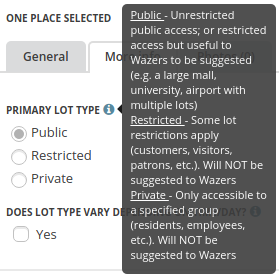
| 09:28, 2 April 2017 | Parking lot type.png (file) |  |
32 KB | Using the US English language translation in WME | 1 |
| 04:26, 28 March 2017 | Checkbox.png (file) |  |
2 KB | 1 | |
| 04:25, 28 March 2017 | Unpaved attribute.png (file) | 7 KB | 2 | ||
| 18:46, 27 March 2017 | Doctor Clinic Place Category.png (file) | 2 KB | 1 | ||
| 18:44, 27 March 2017 | Hospital Urgent Care Place Category.png (file) | 2 KB | 1 | ||
| 04:33, 23 March 2017 | Feedback.jpg (file) |  |
32 KB | 1 | |
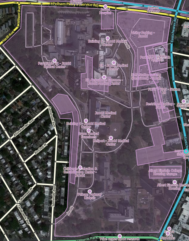
| 04:15, 9 March 2017 | Places medical center.png (file) |  |
836 KB | Medical center mapped with place points for ERs, buildings, and PLAs. Shown with Place Names for visualization. | 1 |
| 15:08, 8 March 2017 | UAE intersection.png (file) |  |
199 KB | copie from legacy wiki | 1 |
| 15:06, 8 March 2017 | UAE Regions.png (file) |  |
278 KB | 1 | |
| 07:58, 20 February 2017 | NA wazers black.jpg (file) |  |
552 KB | 1 | |
| 07:56, 20 February 2017 | NA wazers white.png (file) |  |
183 KB | 1 | |
| 02:02, 20 February 2017 | Wiki Canada@2x.png (file) |  |
19 KB | 1 | |
| 03:44, 16 February 2017 | Ground level lots spanning streets mapped separate.png (file) |  |
1.04 MB | 1 | |
| 03:43, 16 February 2017 | Elevated lot over street.png (file) |  |
1.96 MB | 1 | |
| 02:24, 16 February 2017 | RTC-CrossStreet-060n.png (file) |  |
32 KB | Updated version of File:RTC-CrossStreet-060.png | 1 |
| 02:23, 16 February 2017 | RTC-CrossStreet-030n.png (file) |  |
35 KB | updated version of File:RTC-CrossStreet-030.png | 1 |
| 09:19, 15 February 2017 | Live-wazers-PesachZf.png (file) |  |
7 KB | 1 | |
| 01:28, 5 December 2016 | WME parking lots layer on.png (file) |  |
32 KB | 1 | |
| 20:19, 1 December 2016 | Underground lot with multiple places.png (file) |  |
541 KB | 1 | |
| 19:49, 1 December 2016 | Underground lot with multiple access.png (file) |  |
543 KB | 1 | |
| 17:33, 30 November 2016 | Underground lot mapped to entrance.png (file) |  |
1.55 MB | Proper way to map an underground lot only above ground and ramp areas. | 1 |
| 17:31, 30 November 2016 | Underground lot mapped to perimeter.png (file) |  |
1.56 MB | This is the wrong way to map an underground lot estimating the underground footprint of the garage. | 1 |
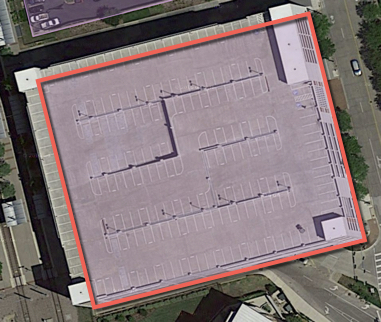
| 13:45, 15 August 2016 | Waze PLA Example.jpg (file) |  |
165 KB | 2 | |
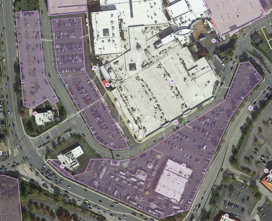
| 13:44, 15 August 2016 | Waze PLA Mall Example.jpg (file) |  |
828 KB | 2 | |
| 07:26, 31 July 2016 | Csastephen.jpg (file) |  |
35 KB | 1 | |
| 05:25, 2 May 2016 | Off button.png (file) |  |
144 KB | 1 | |
| 05:25, 2 May 2016 | On button.png (file) |  |
121 KB | 1 | |
| 23:28, 1 May 2016 | Debug Bee.png (file) |  |
19 KB | 2 | |
| 06:10, 28 April 2016 | Vn.png (file) |  |
9 KB | 1 | |
| 06:06, 28 April 2016 | Sg.png (file) |  |
4 KB | 1 | |
| 04:14, 25 April 2016 | Checklist.png (file) |  |
116 KB | 1 | |
| 03:46, 25 April 2016 | WME username level.png (file) |  |
16 KB | WME Username, avatar, level, and points | 1 |
| 05:14, 7 March 2016 | Speed limit RA sign.png (file) |  |
25 KB | 2 | |
| 04:18, 7 March 2016 | Speed limit RA same.png (file) |  |
28 KB | No SL on the RA, but all exits and approaches have identical limit | 1 |
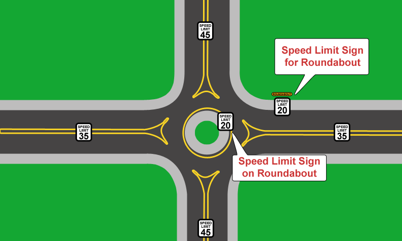
| 04:16, 7 March 2016 | Speed limit RA.png (file) |  |
38 KB | SPEED LIMITS ARE DIFFERENT FOR VARIOUS EXITS, BUT THE RA HAS AN ASSIGNED LIMIT | 3 |
| 02:40, 1 March 2016 | Median segment.png (file) |  |
40 KB | 6 | |
| 01:24, 1 March 2016 | Median segment SL sign.png (file) |  |
3 KB | 1 | |
| 01:24, 1 March 2016 | Median segment SL Int.png (file) |  |
3 KB | 1 | |
| 22:43, 21 February 2016 | Advisory Speed Plaque.png (file) |  |
21 KB | MUTCD W13-1P | 1 |
| 07:54, 12 February 2016 | Toggelis Waze Editor.png (file) |  |
5 KB | 1 | |
| 07:53, 12 February 2016 | Toggelis Waze Editor Screenshot.png (file) |  |
83 KB | 1 |