This special page shows all uploaded files.
| Date | Name | Thumbnail | Size | Description | Versions |
|---|---|---|---|---|---|
| 19:23, 12 January 2021 | PUR Detail.png (file) |  |
38 KB | 1 | |
| 11:15, 20 July 2020 | Chaussées séparées Hors Agglo.png (file) |  |
35 KB | Resize | 2 |
| 11:16, 20 July 2020 | 2x1 voie separateur beton.png (file) |  |
34 KB | Resize | 2 |
| 17:10, 27 April 2020 | Calque Lieux.png (file) |  |
34 KB | 3 | |
| 11:17, 20 July 2020 | 2x1 voie simple ligne.png (file) |  |
32 KB | Resize | 2 |
| 11:17, 20 July 2020 | 2x1 voie double ligne.png (file) |  |
31 KB | Resize | 2 |
| 13:51, 1 May 2020 | Orsay.png (file) |  |
31 KB | 1 | |
| 11:48, 28 April 2020 | Zone edition.png (file) |  |
30 KB | 1 | |
| 13:48, 1 May 2020 | D70Vesoul.png (file) |  |
30 KB | 1 | |
| 13:13, 28 April 2020 | Routes Proprietes.png (file) |  |
29 KB | 4 | |
| 20:25, 29 April 2020 | POI Points Lieux.png (file) |  |
29 KB | 1 | |
| 16:00, 27 April 2020 | FR Liste Calques.PNG (file) |  |
29 KB | Mise à jour visuel | 2 |
| 11:19, 20 July 2020 | 2x2 voies double ligne.png (file) | 29 KB | Resize | 2 | |
| 10:03, 22 May 2014 | Routes Limites Zone.png (file) |  |
28 KB | Limite de zone d'édition | 1 |
| 11:20, 20 July 2020 | 2x2 voies rail beton.png (file) |  |
27 KB | Resize | 2 |
| 18:40, 29 November 2020 | Fermeture.png (file) | 26 KB | 1 | ||
| 11:20, 20 July 2020 | 2x2 voies rail metal.png (file) | 26 KB | Resize | 2 | |
| 16:35, 5 May 2020 | Types.png (file) |  |
25 KB | 1 | |
| 15:53, 27 April 2020 | FR Zone Info.png (file) |  |
24 KB | 1 | |
| 21:54, 17 December 2020 | MP on map.png (file) |  |
22 KB | 1 | |
| 21:19, 13 February 2018 | Lieux-dits.png (file) |  |
22 KB | 2 | |
| 18:48, 8 March 2019 | Boite de Jonction.PNG (file) |  |
21 KB | 1 | |
| 20:22, 27 April 2020 | Red arrows.png (file) |  |
21 KB | 1 | |
| 20:04, 29 November 2020 | FR Renseigner MTE.png (file) |  |
20 KB | 1 | |
| 14:33, 27 April 2020 | 1 Flux.png (file) |  |
20 KB | 1 | |
| 11:55, 6 June 2020 | FR Chemin Cas1.PNG (file) |  |
18 KB | 2 | |
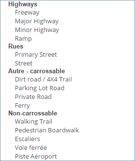
| 15:18, 24 February 2015 | Class types.png (file) |  |
18 KB | Classification : types de voie | 1 |
| 10:55, 26 April 2020 | Menu lieux.png (file) |  |
17 KB | 1 | |
| 16:31, 21 May 2023 | Waze France Main.png (file) |  |
17 KB | 1 | |
| 12:12, 6 June 2020 | FR Chemin Cas3.PNG (file) |  |
17 KB | 1 | |
| 10:07, 26 April 2020 | Menu home.png (file) |  |
17 KB | 1 | |
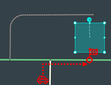
| 19:39, 9 December 2020 | Roundabout - ramp.png (file) |  |
17 KB | 4 | |
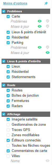
| 18:43, 8 March 2019 | Menu Calques.png (file) |  |
16 KB | 2 | |
| 22:37, 13 February 2019 | FR Menu Calques.PNG (file) |  |
16 KB | 1 | |
| 17:21, 8 March 2019 | Zone de recherche.png (file) |  |
16 KB | Version 2018 | 2 |
| 20:01, 5 February 2019 | FR Recherche.PNG (file) |  |
16 KB | 1 | |
| 12:04, 6 June 2020 | FR Chemin Cas2.PNG (file) |  |
16 KB | 1 | |
| 15:48, 5 April 2021 | Hello.png (file) |  |
16 KB | 1 | |
| 21:52, 17 December 2020 | MP Detail.png (file) |  |
16 KB | 1 | |
| 10:26, 11 October 2020 | FR PN Positionnement.png (file) |  |
16 KB | 1 | |
| 20:28, 5 February 2019 | FR Lieux.PNG (file) |  |
16 KB | 1 | |
| 14:18, 20 July 2020 | Intersection wme HH.png (file) |  |
15 KB | 1 | |
| 11:03, 26 April 2020 | Menu guidage.png (file) |  |
15 KB | 1 | |
| 11:40, 9 May 2020 | FR Guidage App.png (file) | 14 KB | 1 | ||
| 17:01, 17 December 2014 | Panneau D21a.png (file) |  |
14 KB | Panneau vert - Accès autoroute | 2 |
| 13:09, 19 May 2014 | Routes flèches.png (file) |  |
14 KB | Validation des flèches | 1 |
| 14:34, 27 April 2020 | 2 trajets.png (file) |  |
14 KB | 1 | |
| 14:38, 27 April 2020 | 4 Pref.png (file) |  |
14 KB | 1 | |
| 13:11, 28 April 2020 | Creer route.png (file) |  |
13 KB | 1 | |
| 13:09, 19 July 2020 | -FR-Commune INSEE.png (file) |  |
13 KB | 1 |