This special page shows all uploaded files.
| Date | Name | Thumbnail | Size | Description | Versions |
|---|---|---|---|---|---|
| 16:10, 9 September 2021 | 01 Champ Global Badge small.png (file) | 24 KB | 1 | ||
| 16:12, 9 September 2021 | 02 Local Champ Badge.png (file) | 14 KB | 1 | ||
| 16:12, 9 September 2021 | 03 Coordinator.png (file) |  |
10 KB | 1 | |
| 16:13, 9 September 2021 | 07 Emeritus local champs blue.png (file) |  |
20 KB | 1 | |
| 06:12, 22 February 2024 | AUS-PH-App Notification.jpeg (file) |  |
347 KB | A pop up message from the Waze application educating drivers about permanent hazard notifications. | 1 |
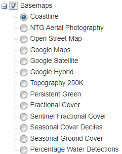
| 11:07, 10 February 2020 | AU NT Natural Resource Maps Caution Layers.png (file) |  |
26 KB | 1 | |
| 11:04, 10 February 2020 | AU NT Natural Resource Maps Enabled.png (file) |  |
65 KB | 1 | |
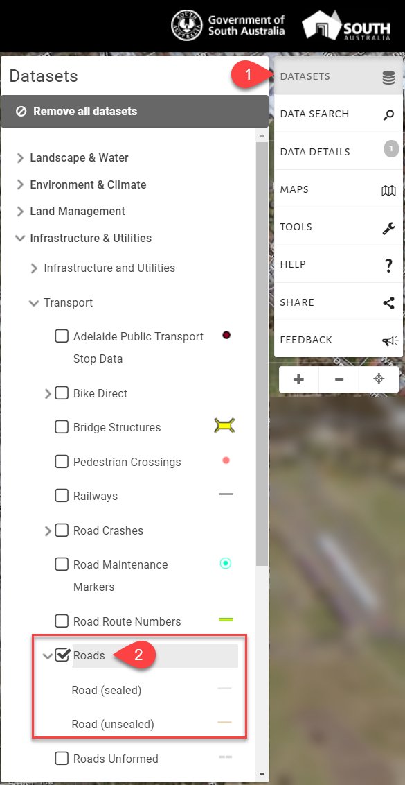
| 11:12, 10 February 2020 | AU SA Permitted Basemaps.png (file) |  |
377 KB | 1 | |
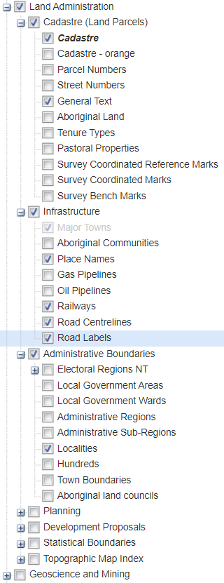
| 11:11, 10 February 2020 | AU SA Permitted Dataset.png (file) |  |
213 KB | 1 | |
| 03:53, 11 February 2020 | AU SA Permitted Dataset v2.png (file) |  |
216 KB | 1 | |
| 10:40, 10 February 2020 | AU video Load-PSMA-data-into-QGIS.jpg (file) |  |
8 KB | 1 | |
| 10:56, 10 February 2020 | AU video Load ACT Road Centrelines data into QGIS via API.jpg (file) |  |
6 KB | 1 | |
| 10:53, 10 February 2020 | AU video Load ACT Road Centrelines data into QGIS via File.jpg (file) |  |
7 KB | 1 | |
| 11:00, 10 February 2020 | AU video Load NSW Base Map data into QGIS via API.jpg (file) |  |
8 KB | 1 | |
| 12:00, 11 February 2020 | AU video Loading a screenshot into WME Image Overlays.jpg (file) |  |
11 KB | 1 | |
| 11:17, 10 February 2020 | AU video Preferred settings for mapping with MapShareVic.jpg (file) |  |
13 KB | 1 | |
| 11:20, 10 February 2020 | AU video Using the Main Roads Western Australia ArcGIS REST API road assets inside GQIS.jpg (file) |  |
10 KB | 1 | |
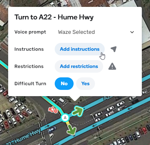
| 02:59, 29 August 2021 | Add-turn-instructions.png (file) |  |
233 KB | Add turn instructions | 1 |
| 06:17, 22 February 2024 | Aus-PH-Alerter01.png (file) |  |
86 KB | 1 | |
| 06:19, 22 February 2024 | Aus-PH-Alerter02.png (file) |  |
188 KB | 1 | |
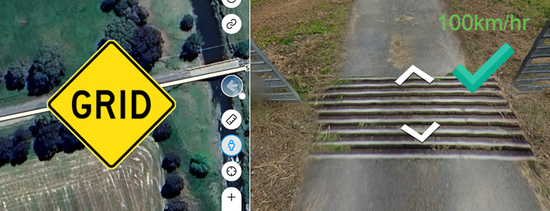
| 06:43, 22 February 2024 | Aus-PH-Grid01.png (file) |  |
478 KB | 1 | |
| 06:54, 22 February 2024 | Aus-PH-Not-A-Speed-bump01.png (file) |  |
506 KB | 1 | |
| 06:37, 22 February 2024 | Aus-PH-Pdestrian-crossing01.png (file) |  |
640 KB | 1 | |
| 06:46, 22 February 2024 | Aus-PH-Rasied-intersection01.png (file) |  |
422 KB | 1 | |
| 06:42, 22 February 2024 | Aus-PH-Rasied-pedestrian-crossing-40-zone-02.png (file) |  |
414 KB | 1 | |
| 06:41, 22 February 2024 | Aus-PH-Rasied-pedestrian-crossing01.png (file) |  |
391 KB | 1 | |
| 05:50, 22 February 2024 | Aus-PH-Sharp curve01.png (file) |  |
160 KB | An example of a hairpin turn/bend seen in Australia where the mapping of a sharp curve is acceptable. | 1 |
| 05:51, 22 February 2024 | Aus-PH-Sharp curve02.png (file) |  |
180 KB | An example of advisory signage where the speed drops by 50km/hr or more, where the mapping of a sharp curve is acceptable. | 1 |
| 05:51, 22 February 2024 | Aus-PH-Sharp curve03.png (file) |  |
645 KB | An example of advisory signage where the speed drops by 50km/hr or more, where the mapping of a sharp curve is acceptable. | 1 |
| 05:52, 22 February 2024 | Aus-PH-Sharp curve04.png (file) |  |
399 KB | An example of red reduce speed sign before a curve, where the mapping of a sharp curve is acceptable. | 1 |
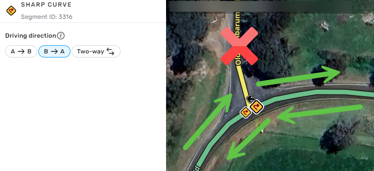
| 05:53, 22 February 2024 | Aus-PH-Sharp curve apex 01.png (file) |  |
225 KB | An example of an intersection at the apex of a sharp curve, where PH should be mapped as one way to avoid alerts to drivers joining from the apex. | 1 |
| 06:49, 22 February 2024 | Aus-PH-Speed-bump-before-shared-speed-zone-entry01.png (file) |  |
927 KB | 1 | |
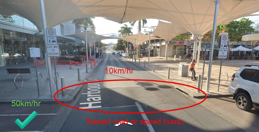
| 06:39, 22 February 2024 | Aus-PH-Speed-bump01.png (file) |  |
498 KB | 1 | |
| 14:32, 9 September 2021 | Beta-tile.png (file) |  |
14 KB | 1 | |
| 13:37, 13 July 2022 | Beta Leader.png (file) |  |
100 KB | Waze Beta Leader | 1 |
| 13:39, 13 July 2022 | Beta Leader 334.png (file) |  |
63 KB | Waze Beta Leader | 1 |
| 13:40, 13 July 2022 | Beta Leader 50.png (file) |  |
5 KB | Waze Beta Leader | 1 |
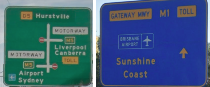
| 02:58, 29 August 2021 | Bgs-green-blue.png (file) |  |
222 KB | Big green signs can also be blue in some states | 1 |
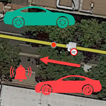
| 10:27, 30 May 2019 | Camera-shutter-direction.png (file) |  |
194 KB | Depicts how Waze will alert based on the direction of the camera shutter. | 1 |
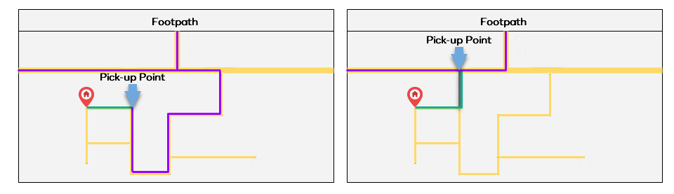
| 01:36, 1 September 2021 | Carpool-pickup-with-footpath.png (file) |  |
11 KB | 1 | |
| 14:32, 9 September 2021 | Carpool-tile.png (file) |  |
25 KB | 1 | |
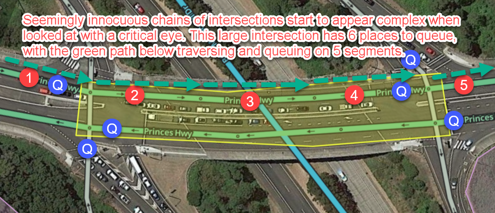
| 01:25, 26 September 2021 | Complex-intersection-for-junction-box.png (file) |  |
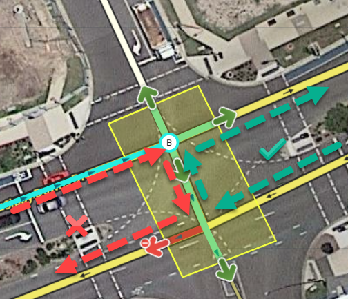
581 KB | An example of a complex intersection that would benefit from a junction box. How long it takes a driver to transition each individual segment inside this complex intersection isn't very useful. It is much more useful for Waze to see this as "one intersection" by adding a junction box, and understand the transitions times for specific routes through it. | 1 |
| 07:57, 29 August 2021 | Complex-intersections-helped-by-junction-box.png (file) |  |
737 KB | Complex intersections should have a junction box | 1 |
| 07:55, 29 August 2021 | Control-uturns-one-way-with-junction-box.png (file) |  |
399 KB | Control u-turns one way and not the other with junction boxes | 1 |
| 15:32, 9 September 2021 | Dino mood 50.png (file) |  |
3 KB | 1 | |
| 07:58, 29 August 2021 | Disable-turn-roundabout-breaks-traffic.png (file) |  |
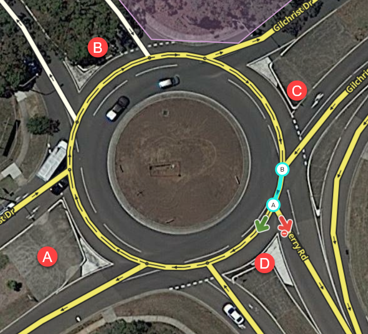
781 KB | You should never disable a turn on a roundabout, use a junction box to disable the path instead | 1 |
| 08:48, 29 August 2021 | Divide-roads-physical-barriers-separate.png (file) |  |
670 KB | Divide roads where there is a physical barrier separating two-way traffic | 1 |
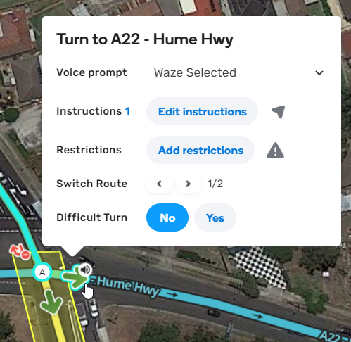
| 02:59, 29 August 2021 | Edit-turn-instructions-on-junction-box.png (file) |  |
232 KB | Edit turn instructions on junction box | 1 |
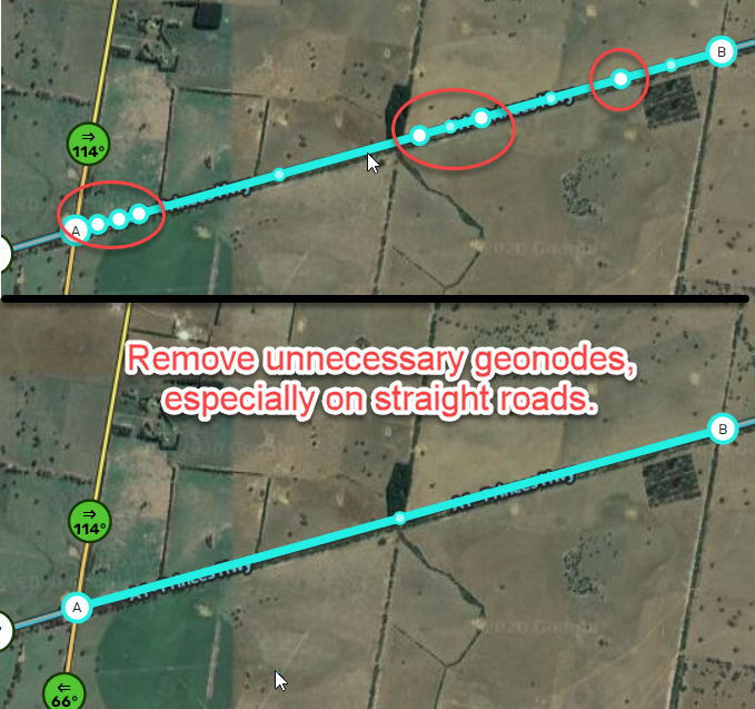
| 08:00, 28 August 2021 | Excess-geo-nodes.png (file) |  |
580 KB | 1 | |
| 01:35, 1 September 2021 | Footpath-Australia.png (file) |  |
24 KB | How footpath segments are routed to | 1 |