This special page shows all uploaded files.
| Date | Name | Thumbnail | Size | Description | Versions |
|---|---|---|---|---|---|
| 11:31, 22 May 2019 | Car-park-uk.png (file) |  |
1 MB | better example | 3 |
| 15:36, 2 April 2020 | RLSE camera Black Dyke.jpg (file) |  |
983 KB | Red Light Safety Enforcement camera at Black Dyke level crossing | 1 |
| 13:11, 29 September 2017 | Shopping-village-uk.png (file) |  |
962 KB | Example of UK Shopping centre mapping. | 2 |
| 14:50, 1 December 2017 | Uk-turn-lane-5.png (file) |  |
954 KB | UK example of turn lane mapped due to segregation. | 1 |
| 15:52, 29 November 2017 | Uk-turn-lane-4.png (file) |  |
905 KB | cleaned up image | 2 |
| 12:50, 29 November 2017 | Uk-complex-junction.png (file) |  |
870 KB | Example of a complex junction | 1 |
| 13:34, 3 December 2017 | Uk-no-turn-lane-1.png (file) |  |
789 KB | removed script highlighting | 3 |
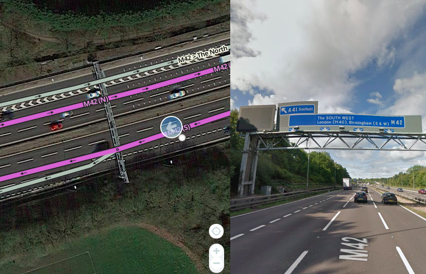
| 15:39, 8 February 2019 | 0-mile gantry.png (file) |  |
782 KB | Example of 0-mile gantry at exit ramp of UK motorway. | 1 |
| 13:40, 3 December 2017 | Uk-no-turn-lane-2.png (file) |  |
716 KB | updated red cross | 2 |
| 13:44, 3 December 2017 | Uk-no-turn-lanes-3.png (file) |  |
712 KB | updated red cross | 2 |
| 16:59, 21 May 2020 | Uk-lg-single-lane.png (file) |  |
677 KB | Example of a single lane for all directions at a junction. | 1 |
| 16:51, 21 May 2020 | Uk-lg-filter-lane.png (file) |  |
661 KB | Example of UK filter lane in WME | 2 |
| 15:23, 2 April 2020 | Cctv-camera-uk.jpg (file) |  |
582 KB | CCTV camera in the UK | 1 |
| 11:18, 28 April 2020 | Uk-box-junction-2.png (file) |  |
531 KB | 3 | |
| 11:17, 28 April 2020 | Uk-box-junction-1.png (file) |  |
530 KB | 3 | |
| 11:20, 28 April 2020 | Uk-box-junction-5.png (file) |  |
524 KB | 3 | |
| 11:19, 28 April 2020 | Uk-box-junction-4.png (file) |  |
523 KB | 3 | |
| 11:20, 28 April 2020 | Uk-box-junction-6.png (file) |  |
522 KB | 1 | |
| 11:21, 28 April 2020 | Uk-box-junction-7.png (file) |  |
520 KB | 1 | |
| 11:19, 28 April 2020 | Uk-box-junction-3.png (file) |  |
519 KB | 3 | |
| 15:28, 2 April 2020 | Cctv-camera-uk-2.jpg (file) |  |
516 KB | Traffic light mounted CCTV camera in the UK | 1 |
| 17:43, 21 May 2020 | Uk-restricted-lane.png (file) |  |
505 KB | Example of UK restricted lane | 2 |
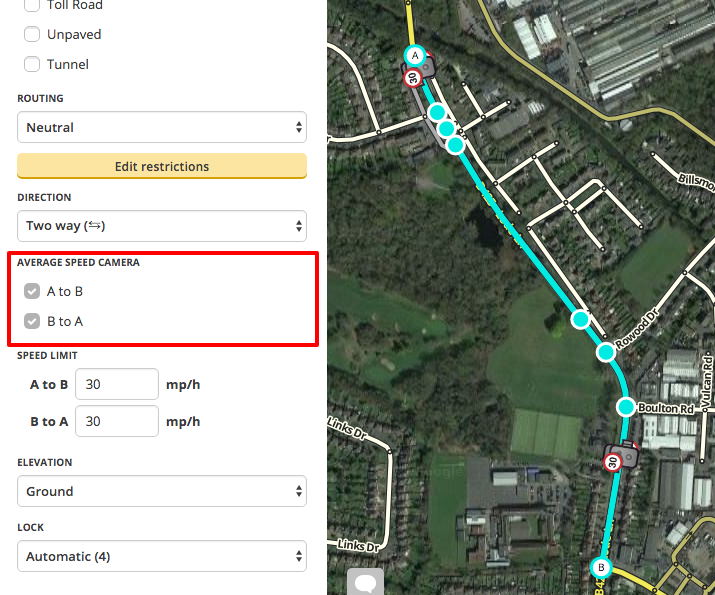
| 11:11, 17 March 2017 | Asc.png (file) |  |
493 KB | Screenshot of WME average speed camera checkboxes. | 1 |
| 20:47, 17 June 2021 | ULEV.png (file) |  |
492 KB | Corrected wording | 2 |
| 15:18, 2 April 2020 | Vector-camera-uk.jpg (file) |  |
490 KB | VECTOR camera used in average speed check in the UK. | 1 |
| 12:41, 22 May 2019 | Bad-car-park-uk.png (file) |  |
486 KB | Example of bad car park mapping in the UK. | 1 |
| 12:41, 22 May 2019 | Good car park uk.png (file) |  |
486 KB | Example of good car park mapping in the UK. | 1 |
| 17:20, 29 September 2017 | Services-uk.png (file) |  |
478 KB | Example of UK service area mapping. | 1 |
| 12:57, 29 September 2017 | Petrol-station-uk.png (file) |  |
452 KB | Example of UK petrol station mapping. | 1 |
| 17:08, 21 May 2020 | Uk-lg-single-direction.png (file) |  |
452 KB | Example of a multiple lane with only one possible direction | 1 |
| 13:02, 13 March 2017 | WME SL.png (file) |  |
404 KB | Screenshot of WME showing Speed Limit entry. | 1 |
| 11:12, 26 April 2020 | Uk-h-junction-1.png (file) |  |
402 KB | 1 | |
| 11:12, 26 April 2020 | Uk-h-junction-2.png (file) |  |
402 KB | 1 | |
| 11:01, 19 November 2017 | Superstore-uk.png (file) |  |
398 KB | now shows correct category | 3 |
| 11:13, 26 April 2020 | Uk-h-junction-4.png (file) |  |
391 KB | 1 | |
| 11:13, 26 April 2020 | Uk-h-junction-3.png (file) |  |
389 KB | 1 | |
| 15:47, 10 September 2018 | Pedestrian area.png (file) |  |
345 KB | Example of Pedestrian Area mapping in the UK. | 1 |
| 19:32, 24 April 2020 | Uk-lane-guidance-add.gif (file) |  |
344 KB | 1 | |
| 14:41, 10 September 2018 | Footpath.png (file) |  |
338 KB | Example of Footpath mapping in the UK. | 1 |
| 15:12, 10 September 2018 | Footpath 2-end.png (file) |  |
327 KB | Example of a footpath connected at both ends in the UK. | 1 |
| 10:43, 2 July 2017 | Bhx-airport.png (file) |  |
313 KB | PLR segment at Birmingham (BHX) airport to improve routing due to Google Maps location. | 1 |
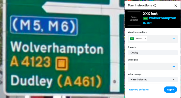
| 20:37, 26 May 2021 | UK-turn-instruction.png (file) |  |
301 KB | Larger image size | 2 |
| 08:30, 27 November 2019 | Add-toll-interface.png (file) |  |
280 KB | Screenshot of the toll tool interface. | 1 |
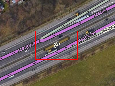
| 10:56, 2 July 2017 | Triangle-junction.png (file) |  |
252 KB | Example of turn restrictions at a triangle junction. | 1 |
| 11:06, 2 July 2017 | Road-shield-marker.png (file) |  |
213 KB | Example of a road shield segment. | 1 |
| 11:51, 13 March 2017 | Report-hazard.jpeg (file) |  |
189 KB | Screenshot of report hazard screen (iOS 4.20.0.1) | 1 |
| 17:40, 28 November 2019 | Add-sections-interface.png (file) |  |
139 KB | Screenshot of toll tool interface. | 2 |
| 11:55, 13 March 2017 | Report-map-issue-2.jpeg (file) |  |
122 KB | Screenshot of report map issue screen 2 (iOS 4.20.0.1) | 1 |
| 12:09, 13 March 2017 | Report-speed-limit-1-2.jpeg (file) |  |
118 KB | Screenshot of reporting speed limit (iOS 4.20.0.1) | 1 |
| 11:58, 13 March 2017 | Report-speed-limit-2.jpeg (file) |  |
106 KB | Screenshot of speed limit issue screen (iOS 4.20.0.1) | 1 |