This special page shows all uploaded files.
| Date | Name | Thumbnail | Size | Description | Versions |
|---|---|---|---|---|---|
| 17:29, 16 May 2014 | Topic read.gif (file) |  |
679 bytes | 1 | |
| 12:30, 28 July 2015 | Point.png (file) |  |
728 bytes | The WME top bar selector for a Point Place. Category:WME Category:Top Bar Category:Add Place Category:Place | 1 |
| 12:27, 28 July 2015 | Area.png (file) |  |
752 bytes | The WME top bar selector for an Area Place. | 1 |
| 14:56, 28 April 2017 | Area place stop point.png (file) |  |
906 bytes | {{As of|2017|04}} The stop point symbol for a Area Place. | 1 |
| 15:44, 17 July 2015 | Junction uneditable.png (file) |  |
1 KB | New Road Layer Colors Duplicate of Junction uneditable.png | 2 |
| 21:15, 16 July 2015 | Uneditable junction.png (file) |  |
1 KB | New road layer colors | 2 |
| 15:39, 17 July 2015 | Junction normal.png (file) |  |
1 KB | New road layer colors | 2 |
| 23:47, 13 September 2017 | Discord-Logo-Color.png (file) | 2 KB | 1 | ||
| 13:55, 28 April 2017 | Wme venue selected2.png (file) |  |
2 KB | New Point Place w/ drag area & stop point. | 1 |
| 21:20, 16 July 2015 | Junction unsaved.png (file) |  |
2 KB | New road layer colors | 3 |
| 21:10, 16 July 2015 | Junction selected.png (file) |  |
2 KB | New road layer colors | 3 |
| 19:37, 10 November 2015 | EditHouseNumbers.png (file) | 3 KB | 1 | ||
| 20:45, 8 February 2018 | R4 wazer.png (file) |  |
4 KB | 1 | |
| 20:48, 8 February 2018 | R3 wazer.png (file) |  |
4 KB | 1 | |
| 20:48, 8 February 2018 | R2 wazer.png (file) |  |
4 KB | 1 | |
| 20:47, 8 February 2018 | R1 wazer.png (file) |  |
4 KB | 1 | |
| 15:17, 25 March 2014 | Twitter-bird-white-on-blue.png (file) |  |
4 KB | Twitter Bird Logo | 1 |
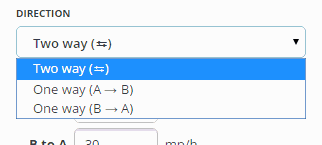
| 17:05, 10 November 2015 | RoadDirectionCB1.png (file) |  |
4 KB | 2 | |
| 15:40, 8 February 2018 | SpecialProperties2015.png (file) |  |
5 KB | Includes HOV and headlights attributes | 2 |
| 20:49, 8 February 2018 | R5 wazer.png (file) |  |
5 KB | 1 | |
| 19:24, 10 November 2015 | RoadLock.png (file) |  |
5 KB | The road lock menu as of the Nov 2015 WME update. | 1 |
| 18:20, 11 November 2015 | Avatar BugLaden.jpg (file) | 5 KB | 1 | ||
| 19:26, 2 May 2020 | Lanes result.png (file) |  |
6 KB | 1 | |
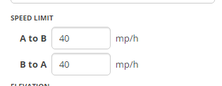
| 17:43, 10 November 2015 | SpeedLimit.png (file) |  |
6 KB | The speed limit fields in the Nov 2015 WME update | 1 |
| 20:50, 8 February 2018 | R6 wazer.png (file) |  |
6 KB | 1 | |
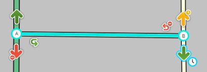
| 20:03, 16 July 2015 | Lotsa turns.jpg (file) |  |
6 KB | New road layer colors. Missing unconfirmed "?", as adjusting one turn confirms all turns at junction. | 4 |
| 16:40, 11 November 2015 | AvatarTerryPurdue.jpg (file) | 7 KB | 1 | ||
| 20:15, 16 July 2015 | Wme turn arrows horizontal 1x1way.jpg (file) | 8 KB | New WME Road Layer Colors | 3 | |
| 19:13, 16 July 2015 | Incomplete.jpg (file) |  |
9 KB | New Road Layer Colors | 2 |
| 19:15, 10 November 2015 | RoadElevation.png (file) |  |
9 KB | The nov 2015 WME elevation menu | 1 |
| 20:19, 16 July 2015 | Wme turn arrows horizontal 1x2way.jpg (file) | 9 KB | New WME road layer colors | 2 | |
| 01:44, 29 May 2020 | Lanes node.png (file) |  |
9 KB | 1 | |
| 14:17, 28 March 2014 | Waze wiki.jpg (file) |  |
10 KB | Reverted to version as of 21:21, 29 September 2013 | 3 |
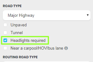
| 15:24, 8 February 2018 | Headlights required.png (file) |  |
10 KB | Enabled checkbox | 2 |
| 03:02, 13 February 2016 | School Speed Sign.gif (file) |  |
12 KB | 1 | |
| 03:24, 13 February 2016 | Speed Limit.gif (file) |  |
13 KB | 1 | |
| 03:16, 13 February 2016 | Exit Sign Speed Plaque.gif (file) |  |
13 KB | 1 | |
| 03:16, 13 February 2016 | Exit Speed Sign.png (file) |  |
14 KB | 1 | |
| 03:15, 13 February 2016 | Advisory Plaque.jpg (file) |  |
14 KB | 1 | |
| 16:51, 11 November 2015 | Avatar JasonN899.jpg (file) | 16 KB | 1 | ||
| 15:50, 11 November 2015 | Avatar nzahn1.png (file) | 16 KB | 2 | ||
| 21:50, 29 July 2016 | Wme landmark address details.png (file) |  |
16 KB | 3 | |
| 21:02, 16 October 2018 | PerpendicularParking.jpg (file) |  |
16 KB | 1 | |
| 20:37, 7 October 2015 | MD RL1.gif (file) |  |
16 KB | Red Light Camera Example, Howard County, Maryland | 1 |
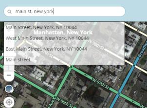
| 15:22, 20 July 2015 | Wme31 main st newyork search results.jpg (file) |  |
17 KB | New road layer colors | 2 |
| 03:15, 13 February 2016 | Right Turn Advisory.jpg (file) |  |
17 KB | 1 | |
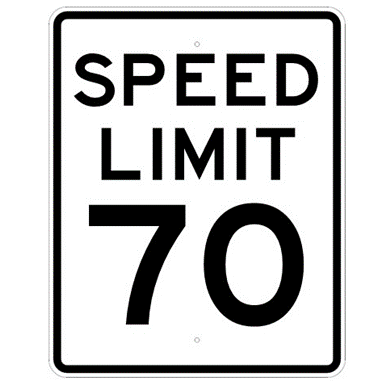
| 03:29, 13 February 2016 | Speed Limit 70.png (file) |  |
17 KB | 1 | |
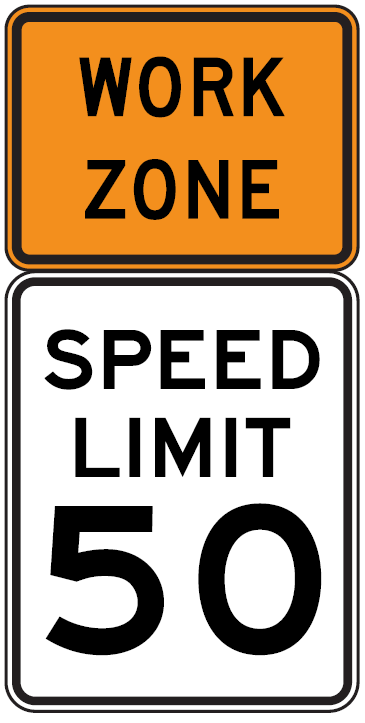
| 15:37, 22 February 2016 | Work zone SL.png (file) |  |
17 KB | Higher Quality | 2 |
| 21:06, 16 October 2018 | OneWayPairPLR.jpg (file) |  |
19 KB | 1 | |
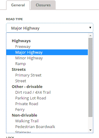
| 16:47, 10 November 2015 | RoadType2015.png (file) |  |
19 KB | The Road Type menu as designed in the Nov 2015 WME revision. | 1 |