 (642 × 574 (639 KB)) - 16:59, 4 November 2015
 (687 × 280 (25 KB)) - 11:17, 11 January 2014
 (354 × 295 (13 KB)) - 11:18, 11 January 2014
 (107 × 95 (10 KB)) - 11:28, 11 January 2014
 Importing file...(360 × 322 (231 KB)) - 12:56, 14 February 2017
 Importing file...(120 × 107 (30 KB)) - 12:56, 14 February 2017
 Importing file...(180 × 161 (65 KB)) - 12:56, 14 February 2017
 Importing file...(270 × 241 (138 KB)) - 12:56, 14 February 2017
 (363 × 527 (36 KB)) - 15:32, 21 January 2021
 (407 × 161 (71 KB)) - 11:12, 15 January 2022
 Importing file...(180 × 150 (5 KB)) - 13:01, 14 February 2017
 Importing file...(120 × 100 (3 KB)) - 13:01, 14 February 2017
 Importing file...(120 × 49 (3 KB)) - 13:23, 14 February 2017
 Importing file...(180 × 73 (5 KB)) - 13:23, 14 February 2017
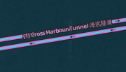 copied from https://wazeopedia.waze.com/wiki/HongKong/File:1_Cross_Harbour_Tunnel_海底隧道.png...(308 × 177 (36 KB)) - 22:52, 11 March 2020
- Road" should have tunnel spelt in full, as it refers to a tunnel. While "Queen Tunnel-Road" could have tunnel abbreviated, as tunnel refers to the type of roadway...2 KB (356 words) - 15:07, 11 May 2015
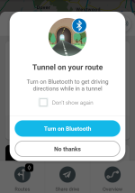 App screenshot of the tunnel warning to turn on bluetooth, provided for routes with waze beacons when the device's bluetooth is off at the start of navigation...(1,080 × 1,539 (184 KB)) - 17:05, 12 October 2021
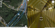 (1,269 × 654 (1.32 MB)) - 16:47, 14 August 2014
 (582 × 574 (32 KB)) - 14:22, 1 October 2018
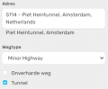 (297 × 244 (10 KB)) - 16:13, 21 January 2021


- regions tunnels are mapped right: Portals of tunnels are aligned with the segment (Many tunnels have a tunnel segment continuing outside the tunnel) Correlationwould normally be at-grade - ground level.. A road going underneath in a tunnel would be below grade. A road going over would be above grade. At complicated