 | Don't map left u-turns. Split road when u-turns are required to properly make turns that are blocked by a median. (https://world.waze.com/editor/?lon=-44... (718 × 566 (382 KB)) - 14:38, 5 October 2012 |
| An example of when to split a junction-based road... 01:40, 20 August 2011 |
be drawn as split roads when it has legal divider. The roads can be drawn as undivided two-way roads when it has legal divider. The roads must be drawn...
2 KB (350 words) - 13:20, 9 August 2016
When creating roundabouts, if the roads are physically "split" then the roads should be split just prior to the roundabout, and flared. https://descartes...
266 bytes (37 words) - 00:01, 13 August 2011
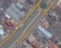
times when it makes sense, however. Here is a Error creating thumbnail: File missing Split? Yes! good example of when to split a junction-based road. This...
4 KB (545 words) - 04:00, 20 August 2011
general the roads in the Waze Map Editor do not need to exactly match the visual appearance on the aerial maps. When it comes to split one-way roads, there...
3 KB (442 words) - 04:17, 17 March 2015
only freeways or major highways are split into two one-way roads. When initially reviewing whether to split or "un-split" (merge back together) a roadway...
25 KB (4,089 words) - 13:32, 30 March 2015
type of road creates problems when people turn from the middle lane because there is no road for the navigation to follow. It is possible and legal to make...
5 KB (572 words) - 22:50, 21 December 2015
unless it is never planned to be reopened. E.g. converted to pedestrian plaza, or demolished roads. Changing the road direction to "Unknown" will not prevent...
12 KB (2,113 words) - 13:38, 30 March 2015
freeway may split into two separate freeways. In order to provide navigation to drivers, it may be necessary to create short segments on the freeway to show the...
4 KB (342 words) - 22:26, 3 March 2016
GPS Track(s), or aerial imagery - Split to 2 one-way roads where appropriate - Addition or Removal of segment nodes when necessary for proper alignment or...
1 KB (135 words) - 20:01, 4 September 2010
are connected to locked segments. Do not split (undivide) roads, even when there lanes are physically split. Do not add non-drivable roads, like pedestrian...
30 KB (3,792 words) - 01:31, 8 March 2020
map and adds to your workload when the time comes to check connectivity, direction, name, etc. Although sometimes referred to as ramps, to Waze these are...
4 KB (642 words) - 06:40, 4 November 2015
5.1 When to use ramps 5.2 Ramp and interchange style 6 Special Cases 6.1 Transitions 6.2 Roads to Nowhere 6.2.1 Actual 6.2.2 Fake 6.3 Offset Roads When...
28 KB (4,630 words) - 17:04, 31 May 2014
connected to locked segments. Do not split roads, even when there lanes are physically split. Do not add non-drivable roads, like pedestrian boardwalks, cycle...
37 KB (4,913 words) - 13:58, 1 February 2020
Metroplex When not to split a two-way road Divided Roads Carpool, HOV, Transit lanes Roundabouts and Traffic Circles Cul-de-sac's FM Roads are to be set to...
21 KB (1,197 words) - 16:14, 24 March 2015
Mode]. back to the Table of Content Most starting editors at first try to match the map of Waze perfectly to the satellite image. They split roads, add bicycle...
22 KB (2,891 words) - 16:05, 3 June 2020
Mode. back to the Table of Content Most starting editors at first try to match the map of Waze perfectly to the satellite image. They split roads, add bicycle...
26 KB (2,795 words) - 21:42, 1 June 2015
direction to 1-way into the complex and road type to Private. On the outbound: change to 1-way going towards the public roads, but leave road type as street...
3 KB (519 words) - 05:36, 30 January 2016
first try to match the map of Waze perfectly to the satellite image. They split roads, add bicycle paths and walking trails, make the roads very fluently...
23 KB (2,767 words) - 22:14, 3 April 2015
