
¡Bienvenido a Waze El Salvador!
¿Qué es Waze?
Waze es una aplicación para navegación móvil por GPS empleada en teléfonos móviles y tablets. Waze cuenta con soporte de voz, actualizaciones gratuitas de mapas; y se basa en información de tráfico en tiempo real y en los reportes de sus usuarios. Usuarios como tú! Con Waze puedes compartir tu experiencia de manejo, conectarte con amigos, enviar tu ETA para compartir el tiempo de llegada a tu destino... o simplemente puedes evadir embotellamientos de tráfico.
- Waze cuenta con la aplicación, comúnmente conocida como cliente o simplemente app. Puedes leer más de la aplicación en las páginas globales de wiki.
- También Waze cuenta con un mapa; el cual es creado y actualizado constantemente por sus usuarios, por medio del Editor de Mapa Waze / Waze Map Editor (WME).
Waze es crowd-sourced pues es administrado por sus usuarios; quienes forman una comunidad que trabaja junta a nivel local, como internacional.
Esta página está enfocada en la comunidad y en la edición de mapas Waze en El Salvador.
Comunidad
La comunidad mantiene el Mapa Waze y se asegura que esté operando lo mejor posible. Como comunidad, se acuerdan las líneas de acción que son específicas del país local, mientras simultáneamente colabora en tareas de Waze Global. La Comunidad Waze El Salvador tiene el mapa completo en un gran porcentaje. Sin embargo, la ayuda de todos los usuarios es importante y necesaria; especialmente en el envío de reportes de errores o inconsistencias, en la actualización de información de los lugares, y editando el mapa.
Para más información, por favor consulte a cualquiera de los líderes locales.
| Comunidad Waze El Salvador | |||
|---|---|---|---|
| Editor | Área | Rol | |
| CM | País |
| |
| AM |
polordonez (PM) |
Zonas Paracentral y Norte |
|
| AM | Zonas Occidental y Sur |
| |
| AM | Zona Norte |
| |
| AM | Zona Oriental |
| |
Comunicación
How can I contact Waze? Where can I find more information? Where can I post my questions? Currently, the Country Managers (CM) are responsible for Waze in Turkey. Please contact them for questions or assistance.
Agréganos en facebook y entérate del tráfico, red vial, y demás temas de interés para conductores de vehículos.
Síguenos en [YYZ twitter]! Podrás blah, blah blah-
Foro
The forum of your own country is a good starting point for finding more information. You can read the latest information, learn from questions of other editors or ask a question yourself. Ingresa al foro salvadoreño using your standard Waze login and password you use in the app and the editor. In the forum you can also make use of Private Messages (PM). This is a kind of inbox, like your e-mail. When you receive a PM, you will also receive a message to your regular e-mail to inform you of the new message. How you can handle your PM's is described here.
Chat

While you are editing, you can directly request help en WME chat. It shows you the level of the editor you are talking to. Please keep in mind that most editors are willing to help, but not all of them have the technical knowledge or editing experience to give you the best answer. Because the built-in chat does not always work as desired, we also tenemos Google Hangouts© en Slack©. Most editors, especially the higher level ones, have an account on both Hangouts and Slack.
Wiki Latinoamérica
Mucha información está disponible en wiki latinoamérica. There are global pages with information applicable to all regions in the World. There are local pages as well. Turkey just started with this Wiki page. Because we have many tourists helping update our maps, this page is available in English too. At the bottom of each Wiki page, the last update is shown. If this is more than half a year ago, please take into consideration that the information might be outdated.
Edición
As the community is starting to grow, we now start to provide some guidelines for editors. We all try to help each other and learn from each other. We hope to be able to help you too.
¿Quieres también ayudar?... Sigue leyendo, y únete a nuestra comunidad de Editores Waze El Salvador.
Cómo comenzar
First of all, read the whole paragraph of this Wiki about editing in Turkey and make yourself acquainted with the basic editing technics described en la página para Editor de Mapas Waze. Then, start improving your home area. You know best how to drive in your area. Ask the community on how things can be handled if Waze acts differently than you expect. If you are satisfied with your home area, check the connecting roads from your town to the nearest towns and, subsequently, to Major Highways and Freeways (links). This is also the moment to consider applying for Area Management (link).
Vías
Nomenclatura
We are depending on local editors for the naming of the roads. As far as we are aware, there are no [El uso de cualquier fuente externa protegida por derechos de autor, sea para agregar información a la base de datos de Waze o a los mapas, no está permitido. Se considera información externa protegida por derechos de autor cualquier información on-line o de mapa impreso aquella que Waze no provea a través de la interface del Editor de Mapas.
Con la adquisición reciente de Waze por parte de Google, Inc. se han ido incorporado imágenes aereas actualizadas e imágenes del street view de Google al Editor de Mapas. Estas las consideramos como fuentes internas y son perfectamente aceptables para ser usadas para crear información del mapa de Waze. Las condiciones de uso de Google limitan el uso de la información de sus mapas a condiciones específicas, para la cual Waze tiene la licencia adecuada para hacer uso de lo que puedes ver dentro del Editor de Mapas, pero nada más.
La utilización de cualquier fuente de información protegida por derechos de autor pone a Waze en la situación de ser forzado a revertir TODOS los cambios realizados en el mapa de tu área/país.
Si algún usuario llegase a hacer tal cosa, perjudicaría todo el trabajo que esa misma persona realizó en los mapas y Waze tendría que revertir todas esas ediciones, aparte de otros efectos adversos. En una ocasión, Waze tuvo que eliminar todos los mapas de Chile y de otros países sudamericanos porque la fuente de esos datos de mapa no tenían licencia (no por acción de Waze).
Cualquier usuario podría negociar con oficiales gubernamentales el acceso a imágenes satelitales que pueda ser de uso para Waze. Se debe procurar evitar dar la impresión de estar actuando en representación de Waze. Más bien, como cuidadano interesado, se puede hablar con una autoridad local, en la lengua local, y explicarle los beneficios que resultan de poner las imágenes satelitales a disposición del público para el bien común.
Debe notarse que una información externa protegida por derechos de autor no incluye cualquier fuente de información que Waze provea a través de las herramientas internas del Editor online o de la aplicación. También, es aceptable cualquier información desarrollada de manera independiente por un usuario que esté físicamente presente en un sitio para ser agregado al mapa, siempre y cuando sea provista sin derechos de autor. fuentes de información externas válidas] available that we could use as a reference. If you don't know the name of the road, check the None boxes after the street name in the edit menu. Specific information for some road types are explained in the paragraph on road types.
Abbreviaciones
We use the Turkish national standards for abbreviations of the roads, according to TDK. Most used abbreviations for WME are:
| name | abbreviation |
|---|---|
| Sokak | Sok |
| Cadde | Cad |
| Kavsak | Kvş |
| Mahalle | Mah |
| Bulvar | Blv |
| Yolu | Yolu |
| Çevreyolu | Çvy |
Categoría de Vías
Roads in WME can be added as street segments or roundabout segments. We can assign typics to each segment in the menu left. We use Functional Classification to choose what kind of segment and road type to use, depending on its use and the needed routing instructions.
Tipos de Vías
- The main roads in a district or town should at least be set to primary.
- If segments will be used for through-going traffic or for longer distances connecting districts or towns, they should at least be mH (minor Highway)
- Main interconnecting roads with fast traffic should be MH (major Highway)
Always make sure a road is at least connected to a same level of road type or higher. Thus, Waze should be able to route from primary to primary (or higher), from minor to minor (or higher), from major to major (or higher), and from Freeway to Freeway. Another way of explaining this, is that you should be able to continuously drive on the same type of segments for the routing engine to use that road type in the calculations.
This means we need to sometimes make small roads mH, for the possibility of calculating long distance routing. Please discuss with the local champs if anything is unclear.
Segmentos Transitables
Autopistas
- Freeways are motorways designed for high speed traffic, connected to other roads exclusively by ramps. All motorways in Turkey are toll roads and numbered O-x or O-xx, where x is the road number. If the road connects to the International E-road network in Europe, it is assigned an E-XX number as well.
- In the main name of the road, only use the road number like O-xx, no city name. If the road has an E-x number as well, use it in the main name with spaces and a dash, like:
- O-4 - E-80
- All other names can be put as an alternative name. However, make sure not to change road names at intersections without consulting this page (to add) or a senior editor, for they affect the routing instructions.
- Major Highways are express roads that are not freeways, and always starts with DXXX. Similar to freeways, there might be alternative name with E-X
- Minor Highways are mostly maintained by local authorities. There is no standard for road naming. We use this road type for through-going traffic or for longer distances connecting cities or towns.
- Ramps are entrance and exit roads to highways and have special functions for routing instructions. See the explanation on Interchanges and other connecting segments for detailed information.
Otras Vías Transitables
- Calles Primarias are main roads in a district or town
- Caminos de Tierra / 4x4 are, contrary to what is seems like, only those roads that need a 4x4 to drive on. Non-paved roads that are drivable for normal cars (and there are many in Turkey) should be typed normal “street”.
- In Turkey, dirt roads are often applied for rivers when dried up. People use those to drive, so we need to map them. To enable dirt roads in routing, you need to specify that in the settings in the client.
- Vías de Paequeos (to be added)
- Calles Privadas' (to be added)
All other drivable roads should be set to Street.
Redondeles / Rotondas
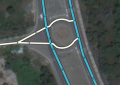
Roundabouts, rotaries, or traffic circles, are unique segments in the Waze routing engine. When a driver approaches a roundabout segment, a specific icon is displayed in the turn direction area of the display with a number corresponding to the exit count from the driver's entry into the roundabout. Manually creating a circular road will not tell Waze to navigate the area as a roundabout. A roundabout gives you instructions like: "On the roundabout, take the 3rd exit" or, "On the roundabout, go left" depending on the way of drawing (link to explanation). A roundabout should be assigned the same road type of the highest classified, ongoing connected road.
However, be careful with roundabouts. In Turkey, many roundabouts should NOT be drawn as a roundabout, to avoid confusing instructions.

Always ask yourself, what kind of instruction will you hear or see in the app? Do that for every road into every direction. In the picture, if you are at segment 3, and want to go to segment 5, you would now get "On the roundabout, take the 2nd exit". That is not conform the actual situation for the driver, who just drives straight. In this case, a roundabout would thus yield confusing instructions.
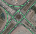
Some alternative solutions for such junctions are the following:
-
Solution to the example
-
Simplified junction, for smaller roads. This still yields the right instructions
-
Looks like a roundabout, but acts like a normal junction.
-
Alway make sure the corners yield the right instructions


Intersections that could cause confusion like described above, should be locked to level 3. If you have any doubt, please ask a senior editor or local champ for advise.
Segmentos No-Transitables
to be added
Estándar de Bloqueo
As the map of Turkey still needs a lot of improvement, we don't want to lock too much that could block starting editors. However, to ensure routing, especially over larger distances, we do use locks for some roads according to the table below. Roads that need more protection because of special situations (construction, complicated design, frequent editing errors) may be locked higher.
| Segment Type | Urban Zone | Rural Zone | |||||||||
|---|---|---|---|---|---|---|---|---|---|---|---|
| Freeway | 5 | ||||||||||
| Ramp | 4 | ||||||||||
| Major Highway | 3 | 4 | |||||||||
| Minor Highway | 3 | ||||||||||
| Primary Street | 2 | ||||||||||
| Street | 1 | ||||||||||
| |-|-|-|-|-|-|-|-|-| Railroad |-|-|-|-|-|-|-|-|-| | 2 | ||||||||||
| • • • • Ferry • • • • | 5 | ||||||||||
Make sure to thoroughly check the routing, before you lock the roads.

Also, in urban areas that are mostly under construction, try to make stubs to the roads: making a short low-level segment for each exit that a low-level editor can attach to. If you need to edit a road above your lock level, ask an unlock (link to?) or ask a higher level editor to do the edit for you.
Límites de Velocidad
Although speed limits are not shown in the app yet, they can be entered via WME. Standard speed limits in Turkey are:
| Road Type | default speed |
|---|---|
| Freeway | 120 |
| Rural road, double lane | 100 |
| Rural road, single two-way lane | 90 |
| Urban road | 50 |
(source: http://www.kgm.gov.tr/Sayfalar/KGM/SiteTr/Trafik/HizSinirlari.aspx)
Please be aware that areas or parts of roads can have different limits. We need local editors to confirm these.
Solicitudes de Actualización / Update Requests (URs)
![]()
![]()
![]()
![]()
Many areas are still not maintained well, and we have very old Update Requests open. As the map currently is not in very good shape, the URs signals where we have to work. Also, it provides a possibility to get into contact with our users. To answer the Update Requests, we have prepared some standard responses; the doc is linked in the Turkish Slack channel too, to easily find it back.
Here is a first guideline for response times, based on the current situation:
for recent URs (<1 month):
- Start with thanking the reporter for reporting the issue.
- If the report is clear and you can solve the issue directly, please do and explain to the reporter what you have done. The reporter receives a message of your comment, and will feel valued for his/her addition. In addition, other editors can learn from your solution and it can help solving other issues in the neighborhood. You can close the UR as solved (standard response).
- When the issue is not clear, ask the reporter politely for more information (standard response).
- If the reporter doesn´t respond to your question within 7 days, you may send a reminder message. It often happens the reporters do respond only after a reminder (standard response).
- When the reporter also does not respond to your reminder within another 2 weeks, you can close the UR as "Not identified", with a comment in the conversation why you closed it (standard response). Meanwhile, there is some time to improve the area, and for the mapupdates to come live.
For reports between 1 and 6 months old, use your best judgement as to how to handle them. You may follow the guidelines above, and use the standard response asking for more info, that includes an excuse for responding late. Again, always try to improve the area before closing the UR.
For older reports (half a year or more), our main focus is to inform the reporter that we are working on the map and they can help if they want (see default response for very old URs). Allow at least two weeks before closing. In addition, before you close the report, try to figure out what the problem was. Always improve the area before you close the UR. Use the "Closing an UR after no feedback" text from the standard responses.
Elaborate information on URs can be read in the general Wiki page on Update Requests. Be aware, that if guidelines differ from what is written above, the Turkish guidelines precede.