Stelling28 (talk | contribs) (Vertaald in het Engels) |
|||
| (86 intermediate revisions by 3 users not shown) | |||
| Line 1: | Line 1: | ||
== Improve your skills == | |||
=Introduction= | =Introduction= | ||
Welcome to this Wiki page. You probably got the advice from another editor to read this page, or a specific part of this page. This advice is given to increase the quality of your edits. The edits for which you were referenced might have been deleted or adjusted in the mean | Welcome to this Wiki page. You probably got the advice from another editor to read this page, or a specific part of this page. This advice is given to increase the quality of your edits. The edits for which you were referenced might have been deleted or adjusted in the mean time. This might be inconvenient, because you miss a specific example. However, realize that the main goal of this advice is to improve your editing skills, while keeping the map up to date. If there is no specific subject that led to the referral of this Wiki page, just globally read the information. Once you need it, come back to the specific section of the subject. We advise you not to try to understand this whole Wiki page with all the details in one go, for it might be overwhelming.<br /> | ||
<br /> | <br /> | ||
Every editor has made mistakes and also everyone, now and then, still does. That's the way most people learn. And most of the times they are not even mistakes. The editing guidelines have developed over several years. So, something that was according to the regulations a year ago, might today be ready for improvement.<br /> | |||
<br /> | <br /> | ||
This Wiki page is not supposed to be a full manual of how to edit the Waze Map. It is an overview of subjects that are often confusing for starting editors, because they did not know the guidelines yet and their own logic tells them differently. This is not | This Wiki page is not supposed to be a full manual of how to edit the Waze Map. It is an overview of subjects that are often confusing for starting editors, because they did not know the guidelines yet and their own logic tells them differently. This is not surprising because many of the guidelines have changed over the years and if you don't know the history, you don't always see the logic. All (starting) editors had this issue. And because guidelines are still changing and will keep changing, this will also happen to more experienced editors. In addition, the technical working of Waze changes often.<br /> | ||
On this Wiki page, we have tried to combine technical knowledge of Waze with the users guidelines in the BeNeLux. To keep duplicate texts to a minimum, we also | <!--On this Wiki page, we have tried to combine technical knowledge of Waze with the users guidelines in the BeNeLux. To keep duplicate texts to a minimum, we also refer to other Wiki pages. <br /><br /> | ||
--> | |||
The best advice we can give to starting editors is to just start and make | The best advice we can give to starting editors is to just start and try to make contact with the community of the country you are editing in. Things will become clear in the process of learning. If something is unclear to you, first try to find it in one of the Wiki pages. If you can't find it, ask your community; Other editors are very willing to help. While reading the information in the Wiki or getting it from other editors, please keep in mind that, like in real life, also in Waze things are not always black and white. That is why we say we don't have rules or regulations, but guidelines. You may receive several opinions from two experienced editors and both can be correct, although a different interpretation. In addition, exceptions to guidelines are always possible and not a problem, provided you have good arguments. <br /> | ||
<br /> | <br /> | ||
=Waze is not a map, but a navigation system= | =Waze is not a map, but a navigation system= | ||
Most mistakes are because of a misunderstanding of the overall principle: 'Waze is not a topographic map, but a navigation tool'. Many starting editors try to make the map in Waze an exact copy of the actual situation. Roads are split; pedestrian boarding walks and cycle paths are added; perfect rounded corners and area places are exactly drawn. The actual goal of Waze is to get the best routing instructions. The less detail on the map, the easier and faster a map can be interpreted during driving, especially on small smartphone screens. <br /> | |||
<br /> | <br /> | ||
Another reason to keep the detail as low as possible is speed. The less details the less bandwidth the downloading of the map requires. Also the less junctions there are, the faster the route calculation is. The number of junctions that Waze can handle in one route is limited. So keeping the number of junctions as low as possible allows for a longer route.<br /> | |||
<br /> | <br /> | ||
To help you Waze has created a number guidelines. That is what this page is about. | To help you Waze has created a number guidelines. That is what this page is about. | ||
| Line 36: | Line 27: | ||
=Editing mistakes are inevitable= | =Editing mistakes are inevitable= | ||
Everybody, without the need of any prior knowledge or practice, can start editing the Waze map. Therefore, Waze accepts the risk that users make edits that seems logical to them, but lead to undesired results. The Waze community is enthousiastic and active, so the mistake will quickly be noticed. A more experienced editor will contact you to correct the mistake or do the correction himself. It is not meant as criticism, but an encouragement to learn more about editing.<br /> | Everybody, without the need of any prior knowledge or practice, can start editing the Waze map. Therefore, Waze accepts the risk that users make edits that seems logical to them, but lead to undesired results. The Waze community is enthousiastic and active, so the mistake will often quickly be noticed. A more experienced editor will contact you to correct the mistake or do the correction himself. It is not meant as criticism, but comes from the drive to have a good map. Take it is an encouragement to learn more about editing.<br /> | ||
Mistakes are often the result of a misunderstood or unknown guideline, or a lack of technical knowledge. In fact, there is only one true "mistake" you can make, which is withholding from communication with other editors.<br /> | Mistakes are often the result of a misunderstood or unknown guideline, or a lack of technical knowledge. In fact, there is only one true "mistake" you can make, which is withholding from communication with other editors.<br /> | ||
=Make sure that other editors can contact you= | =Make sure that other editors can contact you= | ||
The only true mistake you can make as an editor, is being unreachable to other editors. If editors | The only true mistake you can make as an editor, is being unreachable to other editors. If editors spot your edits with an undesired result, or if they don't understand the reason why you made this edit, they will try to contact you. They want to increase the quality of the map and at the same time help you to become a better editor. If other editors cannot reach you, they cannot help you! Moreover, they will probably change your edits according to their own interpretation of the situation.<br /> | ||
Therefore, make sure that you can receive e-mails from Waze by providing a valid mail address. | Therefore, make sure that you can receive e-mails from Waze by providing a valid mail address. Check your mailbox regularly. Also check whether e-mails from Waze are not delivered to your spam- or junkfolder. You might want to make a filter to move the e-mails from Waze to a specific folder, or even create a separate mailbox for Waze. If needed, Adjust your [https://www.waze.com/forum/ucp.php?i=165 Waze settings].<br /> | ||
=Communication= | |||
=Communication | How can I contact Waze? Where can I find more information? Where can I post my questions. The local champs are responsible for Waze in your local community. Please contact one of more of them for questions or assistance. | ||
How can I contact Waze? Where can I find more information? Where can I post my questions. The local champs are responsible | |||
==Forum== | ==Forum== | ||
The forum of your own country is a good starting point for finding more information. You can meet other editors | The forum of your own country is a good starting point for finding more information. You can meet other editors; read the latest information; learn from questions of other editors; or ask a question yourself. You can log in using your standard Waze login and password you use in the app and the editor. In the forum you can also make use of Private Messages (PM), this is a kind of inbox, like your e-mail. When you receive a PM you will also receive a regular e-mail to inform you of the new message. Also if you have installed the 'WME toolbox' you get a message in the editor of new PM's. How you can handle your PM's you can read [[Private_message|here]]. | ||
==Chat== | ==Chat== | ||
When you are editing you can directly request help in [https:// | When you are editing you can directly request help in [https://wazeopedia.waze.com/wiki/Global/Waze_Map_Editor/Chat Waze Map Editor/Chat]. When asking for help you can see the level of the editor you are talking to. Please keep in mind that most editors are willing to help, but not all of them have the technical knowledge or editing experience to give you the best answer. Because the built-in chat does not always work as desired, we also have Google Hangouts© en [https://bit.ly/SlackInvInt/ Slack]©. Most editors, especially the higher level ones, have an account on both Hangouts and Slack. | ||
==Wiki== | ==Wiki== | ||
A lot of information is available in the Wiki of your country. There is one Wiki | A lot of information is available in the Wiki of your country. There is one global Wiki, but at this moment it is not very much up to date | ||
At the bottom of each Wiki page, the date of the last update is shown. If this is more than half a year ago, please take into consideration that the information might be outdated. If a Wiki page is available in several languages, you can select the language at the top of the page. <br /> | |||
<br /> | <br /> | ||
= | <div style="text-align: right; direction: ltr; margin-left: 1em;">[[#TOC|<small>''go back to the table of content''</small>]]</div> | ||
Many misunderstandings have their origin in the fact that the fundamental principles of Waze are not clear. Waze is developed for | |||
=Basic principles of Waze= | |||
Many misunderstandings have their origin in the fact that the fundamental principles of Waze are not clear. Waze is developed for drivers of cars and motorcycles and should not be used for other means of transportation like pedestrians, pedal cyclists, public transport or taxi's, or commercial transport. Also, Waze is not meant to include your personal favorite places, historic railways and illegal shortcuts. | |||
== | ==Usability== | ||
When it comes to the map, the first and foremost goal of editing is to provide the driver with a map that is easy to follow on a small display, and to produce sensible verbal instructions when (and only when) they are needed. | |||
==Simplicity== | ==Simplicity== | ||
It is not a goal to model the physical roadway lane-by-lane. Doing so often leads to unnecessary complexity--which means a cluttered map, confusing verbal directions, and lots and lots (and lots!) of extra map maintenance. | |||
== | ==Retention== | ||
As a result of people driving over them, road segments retain certain information (e.g., average speed) that is used in route optimization. When a segment is deleted, that information is deleted too. Given a choice between deleting a tangle of segments and creating new ones in their place, vs. untangling them and reusing them, it is often better to "recycle". | |||
<br /> | |||
<br /> | <br /> | ||
Another reason to be cautious with deleting segments is that another editor had a reason to add it. And when he or she sees that the segment is deleted without getting notified, this can be very demotivating. Everybody can make a mistake, or guidelines can be changed over time. Preferably consult with the editor who added the segment, rather than change the segment yourself. | |||
<div style="text-align: right; direction: ltr; margin-left: 1em;">[[#TOC|<small>''go back to the table of content''</small>]]</div> | |||
<div style="text-align: right; direction: ltr; margin-left: 1em;">[[#TOC|<small>'' | |||
<br /> | <br /> | ||
=Common functional | =Common functional problems= | ||
Incorrect or incomplete data can have a negative effect on the navigation or make it | Incorrect or incomplete data can have a negative effect on the navigation or even make it impossible to navigate to a specific location. We call these functional mistakes and they should be corrected as soon as possible. Functional mistakes are, if noticed by an other editor, often directly corrected because of the great impact to the functionality of the App. | ||
<!-- Ik heb hier het stuk over het doorlezen van het hele stuk bewust weggelaten. Dit omdat dit feitelijk ook al in de inleiding staat. --> | <!-- Ik heb hier het stuk over het doorlezen van het hele stuk bewust weggelaten. Dit omdat dit feitelijk ook al in de inleiding staat. --> | ||
{{anchor|Red_Roads}} | |||
== | ==Unnamed roads== | ||
[[File:Redroad.png|thumb|left| | [[File:Redroad.png|thumb|left|x323px|Example of an unnamed road]] | ||
[[File:Redroad_fixed.png|thumb|right| | [[File:Redroad_fixed.png|thumb|right|x323px|The road is corrected]] | ||
{{clear}} | |||
When a road does not have a city- or street name it will | When a road does not have a city- or street name, it will get a red outline in WME and it won't be used for navigation. These roads can originate from <br /> | ||
# Paving roads, who have not been confirmed in the WME. | # Paving roads, who have not been confirmed in the WME. | ||
# an editor added a road, but forgot to give it a name. | # an editor added a road, but forgot to give it a name. | ||
<br /> | <br /> | ||
Fill in the city and street name by selecting the segment, than click | |||
[[File:WME_menu_edit_streetname_pencil.PNG]] in the top left of the menu. If you don't know the name of the street or the city, check ''None''.<br /> | |||
<br /> | <br /> | ||
Before you delete a segment, first consult the editor who added it. If you think the segment is an improvement to the map, fill in the missing data. Also check the junction arrows; when an editor has forgotten to fill in the name, probably the junction arrows are not set either. | |||
Read more information in: [[User:Moweez/WME_Quick-Start#Create_a_Road|Create a road]].<br /> | |||
<div style="text-align: right; direction: ltr; margin-left: 1em;">[[#TOC|<small>''go back to the table of content''</small>]]</div> | |||
== | ==Junction Arrows (JA)== | ||
Junction arrows used to be called Turn Restrictions. Junction Arrows are the red, green en orange arrows when you select a segment. They control which turns are allowed. Green is allowed, red is not allowed and orange is [[Partial_restrictions|partially restricted]]. Restrictions can be set in time, vehicle type or passes if applicable. | |||
[[File:CorruptedTurn.png|left|thumb|310px|'''Incorrect:''' An editor | [[File:CorruptedTurn.png|left|thumb|310px|'''Incorrect:''' An editor forgot to correct the junction arrows. Once you drive on the selected segment Waze does not know which instruction to give.]] | ||
[[File:CorruptedTurn_fixed.png|right|thumb|310px|'''Correct:''' you cannot turn left, but you can take a right turn.]] | [[File:CorruptedTurn_fixed.png|right|thumb|310px|'''Correct:''' you cannot turn left, but you can take a right turn.]] | ||
{{clear}} | {{clear}} | ||
When you change the driving direction of a segment always | When you change the driving direction of a segment always remember to check the junction arrows. The WME does not adjust them automatically based on the driving direction. The quickest way to correct hem is to select the junction and press q and w or click on the button 'Allow all turns'. When creating a new road by default all JA's are red. In the advanced settings of the editor check the option 'Draw new roads with all turns allowed'. If you select this option, it is advised to also check the option 'Draw new roads as two-way'. | ||
<!-- Ik heb er bewust voor gekozen om het stuk over de hoeken hierin niet op te nemen. Het heeft m.i. weinig te maken met de functionele fout van een afslagbeperking. Het bepaalt alleen welke instructie er wordt gesproken. --> | <!-- Ik heb er bewust voor gekozen om het stuk over de hoeken hierin niet op te nemen. Het heeft m.i. weinig te maken met de functionele fout van een afslagbeperking. Het bepaalt alleen welke instructie er wordt gesproken. --> | ||
An easy way to check incorrect red | An easy way to check incorrect red junction arrows is Shift-Z. This will show all the red arrows in the area on your screen, also for the not selected segments. Of course these are not all incorrect, but you can check them. It is advised to before you do the correction, you press Shift-Z again and select the segment with the red arrow. Otherwise you can not see which segment has the red arrow. | ||
<div style="text-align: right; direction: ltr; margin-left: 1em;">[[#TOC|<small>''go back to the table of content''</small>]]</div> | <div style="text-align: right; direction: ltr; margin-left: 1em;">[[#TOC|<small>''go back to the table of content''</small>]]</div> | ||
== | ==Disconnected segments== | ||
Even when segments appear to be connected on your screen, it does not necessarily mean they actually are properly connected. The fastest way to check this is to select one of the segments. When you don't see the Junction Arrow(s) light up, it is not connected. | |||
[[File:Failed_attach_shown.png|left|thumb|320px|No visible arrows | [[File:Failed_attach_shown.png|left|thumb|320px|No visible arrows, thus not connected. The selected road will be handled as a dead-end road.]] | ||
[[File:Failed_attach_fixed.png|right|thumb|320px|You see the arrows, | [[File:Failed_attach_fixed.png|right|thumb|320px|You see the arrows, thus the roads are connected.]] | ||
{{clear}} | {{clear}} | ||
When a road should be connected, please check the [[User:Moweez/WME_Quick-Start#Junction_Arrows|Junction Arrows]]. If it is not connected, move the end node away from where it should connect, and drop it somewhere else. Than pick it up again and drag it to where you want the junction to be. WME now automatically creates a junction. Again, check the [[User:Moweez/WME_Quick-Start#Junction_Arrows|Junction Arrows]]. | |||
If you cannot connect a segment using the above described method, one of the segments could have a lock level higher than your editing level. In that case you cannot solve this functional mistake yourself and you might want to ask for an [[User:Moweez/Improve_your_skills#Locked_segments|unlock]]. If the segment is a pedestrian boardwalk, check whether this segment should be connected anyway. If you are unable to connect the segment and cannot get a hold of a more senior editor that can make the connection, leave a gap between the 2 segments. That makes it clear to other editors that this segment still needs to be connected. If you place it onto the other segment it will look ok at first glance but routing instructions will not function properly. | |||
<div style="text-align: right; direction: ltr; margin-left: 1em;">[[#TOC|<small>''go back to the table of content''</small>]]</div> | |||
==Locked segments== | |||
[[File:WME_SegmentLock.JPG|thumb|upright=1.4]] | |||
To protect the map from unwanted errors, some segments are secured with a lock. Important main roads will show higher locks than small side streets. Locked roads can only be changed by editors with a rank the same or higher than the lock level. Even if you succeed to edit such a segment, you won't be able to save your changes. Also, you will not be able to connect other roads to locked roads. If you try to do that, it will result in [[User:Moweez/Improve_your_skills#Disconnected_segments|disconnected segments]], like described in the previous paragraph.<br /> | |||
When you want to change a segment with a higher lock level than your own rank, propose your changes to a higher rank editor, or ask a temporary decrease in lock level. You always need to make a [[User:Moweez/WME_Quick-Start#How_to_make_a_permalink|permalink]], and specify the region or city, and the needed rank. | |||
Use one of the following methods: | |||
* Use the appropriate channel in one of the [[User:Moweez/Improve_your_skills#Chat|chat platforms]]. | |||
* Use a private message (DM or PM, in forum, Slack, or Hangouts) to ask the last editor, who is visible at the bottom left of your screen when selecting the segment. If you do not get a response, you can also ask the Area manager or one of the Local Champs of your country instead. | |||
<!--* Place your request in the map modification forum of [http://bit.ly/forummapmod_Be Belgium], [http://bit.ly/forummapmod_Nl the Netherlands], or [http://bit.ly/forummapmod_Lux Luxembourg]. --> | |||
<div style="text-align: right; direction: ltr; margin-left: 1em;">[[#TOC|<small>''go back to the table of content''</small>]]</div> | |||
==Incorrect use of roundabouts== | |||
When approaching a roundabout specific instructions are given. For a standard roundabout (4 exits) the instruction is 'Turn left at the roundabout'. For other roundabouts the instruction will be 'Take the third exit at the roundabout'. If these instructions are not correct for the situation, please don't use a roundabout. A dead-end street should not have a roundabout at the end. If there is no road sign for a roundabout don't use a roundabout. This will give incorrect instructions, where a driver thinks he is approaching a roundabout, when this is not the case. for more information about how to create a roundabout see [User:Moweez/WME_Quick-Start#Create_a_roundabout Quick Start Guide]. | |||
<div style="text-align: right; direction: ltr; margin-left: 1em;">[[#TOC|<small>''go back to the table of content''</small>]]</div> | |||
<div style="text-align: right; direction: ltr; margin-left: 1em;">[[#TOC|<small>''go back to the table of content''</small>]]</div> | |||
==Private access roads that distort routing== | |||
Many new editors enthusiastically start mapping all small streets, alleys, driveways, parking lot roads, etc. They think "if I can drive on it, I should map it". But this can have some negative effects. Of course it means a lot of extra data (bandwidth) and extra calculations. Also it can make the map less clear on small screens. But the biggest disadvantage is that it can distort the routing. | |||
The way Waze works is that is it finds your destination based on GPS coordinates, in a lot of cases from Google. Based on those coordinates it pins your destination. Then it looks for the closest drivable road, without looking at the name of that road. So that means if the driveway of the rear neighbors is closer to the pin of your destination then you will be lead to the wrong road. And when this is a long road, it can be far of from your actual destination. | |||
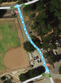
[[File:AccessRoad_distorts_routing.png|thumb|left|450px|'''An access road that will distort routing.''']] | |||
[[File: | {{clear}} | ||
<div style="text-align: right; direction: ltr; margin-left: 1em;">[[#TOC|<small>''go back to the table of content''</small>]]</div> | |||
== Too much or incorrect geometry nodes== | |||
This section is moved to the heading 'Too_much_geometry_nodes'. | |||
< | =Local agreements (that are not logical at first glance)= | ||
<!-- Ik zou hier een aparte kop van maken en redelijk bovenaan zetten. En de uitleg die op meerdere plaatsen hierover staat verwijderen, wellicht als het op die plaats heel relevant is, een link plaatsen. Wellicht zelfs dit stuk verplaatsen naar de Starters guide. Hierom heb ik dit stuk niet vertaald. | |||
Mo: Tja, dat is een hele ingreep. Voorlopig maar even zo houden, dan hebben we het in ieder geval ergens staan.--> | |||
Waze users have gathered to make agreements on how to best implement Waze's functions and features. In addition, every country has different laws, habits and regulations. Therefore, agreements within local communities of Waze also can vary. These agreements may not always seem logical at first. However, they exist to ensure the best navigation possible, with the features Waze offers, and the with the least amount of data used. If you have made edits that were not in accordance with these agreements, you might have been asked to update them. Here is where you can read why. | |||
== | ==The relation between the satellite view and map== | ||
Starting editors often tend to draw the map exactly like the satellite view shows. However, the Waze map should be as simple as possible, in a way that yield the best navigation instructions, with a clear and simple map on screen. This implies that sometimes roads or parts of roads are even NOT drawn, or drawn differently from the satellite view. In addition, the satellite view may be outdated or doesn´t show everything. For example, a road in a forest is probably not visible on the satellite view. Thus, use the satellite view as a source, not as a goal to copy. In case the road is mapped differently, please consult the previous editor or the area manager.<br /> | |||
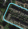
[[File:TryingTooHard.png|thumb|left|320px|'''Roads added according to Satellite View.''' ]] | |||
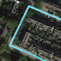
[[File:TryingTooHard_fixed.jpg|thumb|right|320px|'''Waze Map:''' A single segment yields a simple and clear routing, that is easy to maintain.]] | |||
{{clear}} | |||
Many examples can be found in [[Benelux_Advanced_Guide|Advanced editing Guide]]. | |||
= | <div style="text-align: right; direction: ltr; margin-left: 1em;">[[#TOC|<small>''go back to the table of content''</small>]]</div> | ||
[[ | |||
== Too many geometry nodes== | |||
Too many geometry points can slow down the build of your screen. Also, it is harder to maintain the map. Therefore, we use as few nodes as possible, even if that means that a road in Waze does not exactly follow the road in the Satellite View. If a segment has too many nodes, please remove them by hovering your mouse over the nodes, and press 'd'. | |||
<gallery> | <gallery> | ||
File:GeometryNodes_excessive.png|<small><span style="color:#FF0000"><translate> | File:GeometryNodes_excessive.png|<small><span style="color:#FF0000"><translate>Too many geometry nodes (13 nodes)</translate></span></small> | ||
File:GeometryNodes_efficient.png|<small><span style="color:#008000"><translate> | File:GeometryNodes_efficient.png|<small><span style="color:#008000"><translate>This is efficiënt (3 nodes)</translate></span></small> | ||
</gallery> | </gallery> | ||
<gallery> | <gallery> | ||
File:WME geometry corner toomanynodes.PNG|<small><span style="color:#FF0000"><translate> | File:WME geometry corner toomanynodes.PNG|<small><span style="color:#FF0000"><translate>Too many geometry nodes</translate></span></small> | ||
File:WME geometry cornerminimumnodes.PNG|<small><span style="color:#008000"><translate> | File:WME geometry cornerminimumnodes.PNG|<small><span style="color:#008000"><translate>This give excelent navigation instructions</translate></span></small> | ||
File:WME geometry cornerreducednodes.PNG|<small><span style="color:#008000"><translate> | File:WME geometry cornerreducednodes.PNG|<small><span style="color:#008000"><translate>If you prefer rounded corners you can use this as an intermediate solution</translate></span></small> | ||
</gallery> | </gallery> | ||
For more information see [https://wiki.waze.com/wiki/Benelux_WME_Quick-Start#Create_a_Road Create a road]. | |||
<div style="text-align: right; direction: ltr; margin-left: 1em;">[[#TOC|<small>''go back to the table of content''</small>]]</div> | |||
==Simplify an intersection== | |||
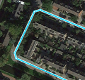
[[File:TryingTooHard.png|thumb|left|320px|'''The actual situation of the intersection.''' In this example, when you draw the roads exactly as the actual situation you will end up with lots of segments and junctions. This will result in a lot of maintenance. Also the driver will get a lot of navigation instructions where one instruction, e.g. "turn left", should be sufficient and is much clearer.]] | |||
[[File:TryingTooHard_fixed.jpg|thumb|right|320px|'''This is the preferred way to draw this intersection.''' This way the driver gets only one navigation instruction and also the map is easy and quick to read on a small screen.]] | |||
{{clear}} | {{clear}} | ||
More examples of drawing complex situations can be found in [https://wiki.waze.com/wiki/Benelux_Advanced_Guide#KISS_-_Keep_It_Stupidly_Simple Advanced guide]. <!-- Deze link is naar het Engels, maar de tekst is dus nog niet vertaald. --> | |||
<div style="text-align: right; direction: ltr; margin-left: 1em;">[[#TOC|<small>''go back to the table of content''</small>]]</div> | |||
==Road types== | |||
<!-- | |||
ST: Ik vind dit eigenlijk niet onder dit kopje horen. Maar om teveel verwarring te voorkomen laat ik het voor nu staan. | |||
In het algemene stuk heb ik de stukken bewust niet vertaald, die even verder op nog een keer staan. Bijvoorbeeld de Walking trails. Het gaat mij in dit geval niet om het dubbele werk, maar ik vind het persoonlijk irritant lezen als ik op zo'n korte termijn inhoudelijk twee keer hetzelfde lees. Alsof de schrijver denkt dat ik de eerste keer niet opgelet of zoiets. | |||
Mo: Ik snap je punt. Denk aan hoe het gebruikt wordt: je geeft een link naar het specifieke topic, waarmee je het 'probleem' wil tackelen | |||
--> | |||
Starting editors often tend to change the road type of a segment.Choosing the type of a road segment has many implications, due to the consequences for visibility, routing and such. These typics can vary across countries and you will see some of these differences when choosing another language in WME. Thus, some road types are differently used than expected at first sight, and some are even not used. If you think a road type should be changed, please consult the last editor or the Area or Region Manager. | |||
= | <div style="text-align: right; direction: ltr; margin-left: 1em;">[[#TOC|<small>''go back to the table of content''</small>]]</div> | ||
===Freeway / Highway=== | |||
[[File: | <!-- Mo: is dit een vertaalprobleem??? niet mee eens hoor ;). Dat heeft er indirect wel mee te maken tav het begrip in het Nederlands, maar dat is dan weer minder relevant op de Engelse pagina. Het is mi in ieder geval niet de kern boodschap van deze alinea. | ||
ST: This is a typical translation issue as menthioned above. Freeway, major highway and minor highway are all translated as 'snelweg' into Dutch. But all tree are used for different purposes or types of roads. | |||
--> | |||
Freeway and Major or minor Highway are road types that are mainly applied based on the amount of traffic they bear compared to other roads in the neighbourhood, the distance they serve in routing, and the passage possibilities. Therefore, a small local road can be defined as minor highway, and a normal street in a city that serves ongoing traffic as a major highway. This way of dealing with Road types is referred to as Functional Classification (FC). Most of the roads that serve ongoing traffic, will be [[User:Moweez/Improve_your_skills#Locked_segments|locked]]. Changes to these segments can only be made by experienced editors with a rank similar or higher than the lock level. If you think a change to a locked segment is needed, ask an editor with the appropriate rank, or place your request in one of the communication channels of the country. | |||
<!-- stuk over locks een aanpassingen staat feitelijk al eerder op deze pagina, dat is hier niets nieuws. Vandaar dat ik het hier heb weggelaten. | |||
Mo: Haha, je bent al heel erg in de pagina opgegaan. Ook hier geldt, als helper geef je een link naar een alinea met het onderwerp, dat het duidelijk moet maken. We raden juist af om de hele pagina in een keer te lezen--> | |||
===Pedestrian boardwalks and cycle paths=== | |||
In general both Pedestrian boardwalks and cycle paths should not be added to the map of Waze, because Waze should only be used by motorvehicles. There are some exceptions and they may be differently applied in countries. <!--[[Pedestrian Boardwalk]] and [[Walking trail]] pages. In the Benelux Pedestrian boardwalks are used for non-drivable roads without destinations, important to connect a parking place with possible destinations and also for public transport (except taxis). Walking trails are used for walking path with destinations. | |||
Both non-drivable road types should be connected to the other roads.--> | |||
===Parking Lots=== | |||
<!-- MO: dit stuk uit intro eventueel hier verwerken? ST: be very careful with changing the type of a road. For example when you change a segment from street to parking lot road (PLR) it can result in drivers needed to drive X extra kilometers, because a PLR has a high penalty. This is done because you don't that drivers use a parking lot as a shortcut to avoid a small traffic jam. Changing the type into PLR is only an example, almost for all types there can be a big influence. --> | |||
Also parking lots should be drawn as simple as possible with the aim at good navigation instructions. There is no value added to draw every lane on a parking lot and with the inaccruarcy of GPS Waze probably does not know on which lane you are exactly, resulting in wrong instructions. Roads on parking lots generally have no name, excepts when the road has a housenumber of an official address that can not be linked to regular street. | |||
[[File:WME_ParkingLot_excessiveroads.PNG|left|thumb|330px|<span style="color:#FF0000"><translate>To much detail</translate></span>]] | |||
[[File:WME_ParkingLot_corrects.PNG|right|thumb|310px|<span style="color:#008000"><translate>Much better</translate></span>]] | |||
{{clear}} | {{clear}} | ||
<!--See [[Benelux_Parking_Lot_Road|Parking Lot Roads]] for more information.--> | |||
<div style="text-align: right; direction: ltr; margin-left: 1em;">[[#TOC|<small>''go back to the table of content''</small>]]</div> | |||
<div style="text-align: right; direction: ltr; margin-left: 1em;">[[#TOC|<small>'' | |||
== | ==Splitting up/dividing roads== | ||
Splitting roads into two single segment for both lanes should only be done when it is needed for navigation. Both splitting/dividing and undividing/merging have advantages and disadvantages. It is hard to give a very clear guideline when is best and when not. It all depends on time and capacity available, the level of the editor, the width of the road, if there are other roads next to it, if there are destinations on one side , possible u-turns and the amount of connecting segments when there is a solid divider. | |||
The fact that a road is physically splitted, is most of the times not a very good ground. With Junction arrows you can make sure that physically impossible turns are restricted. Splitting (or unsplitting) an existing road should only be done after consulting with the region manager or senior editor. Be aware that unsplitting a road takes about the same effort as splitting it. See this videos for the best way to [https://youtu.be/PYtg38iMbog split/divide] or [https://youtu.be/F7CzQZgRf28 merge] segments. | |||
<div style="text-align: right; direction: ltr; margin-left: 1em;">[[#TOC|<small>''go back to the table of content''</small>]]</div> | |||
<!-- TOT HIER--> | |||
==Update request (UR)== | |||
[[File:UR_inconsiderate_closure.png|thumb|left|323px|'''Undesirable''': Most UR's were filed as closed without reason]] | |||
<div style="text-align: right; direction: ltr; margin-left: 1em;">[[#TOC|<small>'' | [[File:UR_healthy_closure.png|thumb|right|323px|'''Desired''': A region where the UR’s have been properly responded to and issues addressed]] | ||
{{clear}} | |||
While driving, a driver can report a problem by submitting an Update Request (UR). Often there is not enough time to fully describe the issue. Therefore, Waze developed the possibility to start a conversation in the UR. Whenever you respond to an UR, you should take this seriously. The user does not report if he or she doesn't encounter a problem! It is your task to solve the problem as best as you can, or find the help needed to solve it. By solving the user's problem, we can improve Waze to serve the needs of all Wazers. Never just close a UR, even if you think it is bogus. Some general guidelines (your country may use different guidelines; always follow the guidelines of the country you are editing in): | |||
[[File:WME UR Window.png|thumb|right|upright=1.4|start a conversation. Be aware that the reporter probably is not an editor.]]<br /> | |||
* Start with thanking the reporter for reporting the issue. | |||
* If the report is clear and you can solve this issue directly, please do and explain to the reporter what you have done. The reporter receives a message of your comment, and will feel valued for his/her addition. In addition, other editors can learn from your solution and it can help solving other issues in the neighborhood. You can close the UR as solved. | |||
* When the issue is not clear, ask the reporter politely for more information. | |||
* If the reporter doesn´t respond to your question within 5 days, you may send a reminder message. It often happens the reporters do respond only after a reminder. | |||
* When the reporter also does not respond to your reminder within 8 days, you can close the UR as "Not identified", with a comment in the conversation why you closed it. | |||
Officially, nobody ´owns´ a UR. However, if another editor is already handling the problem, don't close or take over without consulting this editor. If the editor does not react withing two weeks after the initial response, you may close it as "Not identified".<br /> | |||
[[ | Samples of comments can be found in the script [[Scripts#URComments|WME URComments]]. | ||
< | |||
Elaborate information on URs can be read in the US Wiki page [[Update_Requests_in_Waze_Map_Editor|Update Requests]]. Be aware, that if guidelines differ from what is written above, the guidelines of the country you are editing in take precedence. | |||
<div style="text-align: right; direction: ltr; margin-left: 1em;">[[#TOC|<small>''go back to the table of content''</small>]]</div> | |||
=Starting editors: what they can do and what not= | |||
Everywhere you have driven using Waze you can edit. In the Benelux the maps are quite good, so there is not much to do for a starting editor. Altough at first you might think there is not much to do for you, please zoom in and you can almost always find something to improve. Even in areas with a lot of editors you will find missing parking lot roads or a part of a street is missing. Also sometimes streetnames are missing or misspelled. Most work you can do is to remove unnessary geonometry nodes, see [[#Too_much_or_incorrect_geometry_nodes]]. Read the Wiki and just start editing, that way you will learn to use the editor and earn points to get to a higher level. | |||
Because the maps in the Benelux are already quite good, there is also a risk with editing. You can break things that are working fine. Please be aware that some things might look incorrect or not logical to you, but can be correct based on the [[#The_principles_of_Waze]]. Be carefull with changing and deleting work of other editors. In case of the slighest doubt, first contact the previous editor. | |||
To make this more clear we have made two lists, one of things you can do as a starting editor and one you should not do or be extremly caustious. | |||
<div style="text-align: right; direction: ltr; margin-left: 1em;">[[#TOC|<small>''go back to the table of content''</small>]]</div> | |||
< | |||
== | ==Things a starting Waze-editor can do== | ||
* | * Read the [https://wiki.waze.com/wiki/Benelux_WME_Quick-Start Quick Start Guide]. | ||
* | * Check if streetnames are filled in and spelled correctly. Use [https://wazeopedia.waze.com/wiki/Global/Using_external_sources sources], that we are allowed to use, to check. | ||
* Check if the city is filled in correctly. | |||
* | * Check the driving direction of streets. You can base this on Google Streetview from within Waze, your own local knowledge or other allowed [https://wazeopedia.waze.com/wiki/Global/Using_external_sources sources]. When the source is older than the last edit on the segment, assume that Waze is more up-to-date than your other source and don't change it. | ||
* | * Check if Junction Arrows are set correctly. With Shift-Z you will see all the red arrows. When you suspect a red junction arrow to be incorrect, first do Shift-Z again and select the segment connected to the junction. That way you can see which segment has the red junction arrow. | ||
* | * Check the category, name and address of [[Places|places]]. The name should be the official name of the place. If you know this place is locally called a different name, please add that name as an alternative. It will improve the search. Also check if this place is visible on the live map, if not, please convert it to a point place, when applicable. | ||
* Inform your area or region manager of possible issues. See the section [[#Communication]] how to do that. | |||
* Monitor road-closures in your neighborhood, and communicate them on the forum or via one of the [[#Communication|communication]] channels available for your country. | |||
* | <!--* Help with keeping the Wiki up-to-date and make it better. For example with suggestion to improved existing text or help with translations. See [https://www.waze.com/forum/viewforum.php?f=1415 this forum] how you can help.--> | ||
* Help | |||
<div style="text-align: right; direction: ltr; margin-left: 1em;">[[#TOC|<small>''go back to the table of content''</small>]]</div> | |||
<div style="text-align: right; direction: ltr; margin-left: 1em;">[[#TOC|<small>'' | |||
==Risky activities for starting editors== | |||
Unless you work together with a more experienced editor be very careful with doing one of the following activities. | |||
* Deleting road-segments. This also deletes the historic traffic information, e.g. the historic average speed. | |||
* Do not change or delete segments that are connected to locked segments. | |||
* Do not split roads, even when there lanes are physically split. | |||
* Do not add non-drivable roads, like pedestrian boardwalks, cycle paths, railways, runways and bus lanes. This seems harmless, but they can result in a wrong navigation advice. It will also clutter the map and increase the amount of bandwidth used. | |||
* Do not add parking lots roads when there are alreay roads on the parking lot. See [https://wiki.waze.com/wiki/Benelux_Parking_Lot_Road Wiki PLR]. | |||
* Do change the roadtype, this has a big influence on the navigation. | |||
* Be careful with adding roads, especially private roads and driveways. The same risks as for non-drivable roads apply. | |||
* Do not close update requests or make changes based on them. If you want to help, because you have local knowledge, please make a comment that can help a more experienced editor. | |||
<div style="text-align: right; direction: ltr; margin-left: 1em;">[[#TOC|<small>''go back to the table of content''</small>]]</div> | |||
Latest revision as of 13:58, 1 February 2020
Improve your skills
Introduction
Welcome to this Wiki page. You probably got the advice from another editor to read this page, or a specific part of this page. This advice is given to increase the quality of your edits. The edits for which you were referenced might have been deleted or adjusted in the mean time. This might be inconvenient, because you miss a specific example. However, realize that the main goal of this advice is to improve your editing skills, while keeping the map up to date. If there is no specific subject that led to the referral of this Wiki page, just globally read the information. Once you need it, come back to the specific section of the subject. We advise you not to try to understand this whole Wiki page with all the details in one go, for it might be overwhelming.
Every editor has made mistakes and also everyone, now and then, still does. That's the way most people learn. And most of the times they are not even mistakes. The editing guidelines have developed over several years. So, something that was according to the regulations a year ago, might today be ready for improvement.
This Wiki page is not supposed to be a full manual of how to edit the Waze Map. It is an overview of subjects that are often confusing for starting editors, because they did not know the guidelines yet and their own logic tells them differently. This is not surprising because many of the guidelines have changed over the years and if you don't know the history, you don't always see the logic. All (starting) editors had this issue. And because guidelines are still changing and will keep changing, this will also happen to more experienced editors. In addition, the technical working of Waze changes often.
The best advice we can give to starting editors is to just start and try to make contact with the community of the country you are editing in. Things will become clear in the process of learning. If something is unclear to you, first try to find it in one of the Wiki pages. If you can't find it, ask your community; Other editors are very willing to help. While reading the information in the Wiki or getting it from other editors, please keep in mind that, like in real life, also in Waze things are not always black and white. That is why we say we don't have rules or regulations, but guidelines. You may receive several opinions from two experienced editors and both can be correct, although a different interpretation. In addition, exceptions to guidelines are always possible and not a problem, provided you have good arguments.
Most mistakes are because of a misunderstanding of the overall principle: 'Waze is not a topographic map, but a navigation tool'. Many starting editors try to make the map in Waze an exact copy of the actual situation. Roads are split; pedestrian boarding walks and cycle paths are added; perfect rounded corners and area places are exactly drawn. The actual goal of Waze is to get the best routing instructions. The less detail on the map, the easier and faster a map can be interpreted during driving, especially on small smartphone screens.
Another reason to keep the detail as low as possible is speed. The less details the less bandwidth the downloading of the map requires. Also the less junctions there are, the faster the route calculation is. The number of junctions that Waze can handle in one route is limited. So keeping the number of junctions as low as possible allows for a longer route.
To help you Waze has created a number guidelines. That is what this page is about.
Editing mistakes are inevitable
Everybody, without the need of any prior knowledge or practice, can start editing the Waze map. Therefore, Waze accepts the risk that users make edits that seems logical to them, but lead to undesired results. The Waze community is enthousiastic and active, so the mistake will often quickly be noticed. A more experienced editor will contact you to correct the mistake or do the correction himself. It is not meant as criticism, but comes from the drive to have a good map. Take it is an encouragement to learn more about editing.
Mistakes are often the result of a misunderstood or unknown guideline, or a lack of technical knowledge. In fact, there is only one true "mistake" you can make, which is withholding from communication with other editors.
Make sure that other editors can contact you
The only true mistake you can make as an editor, is being unreachable to other editors. If editors spot your edits with an undesired result, or if they don't understand the reason why you made this edit, they will try to contact you. They want to increase the quality of the map and at the same time help you to become a better editor. If other editors cannot reach you, they cannot help you! Moreover, they will probably change your edits according to their own interpretation of the situation.
Therefore, make sure that you can receive e-mails from Waze by providing a valid mail address. Check your mailbox regularly. Also check whether e-mails from Waze are not delivered to your spam- or junkfolder. You might want to make a filter to move the e-mails from Waze to a specific folder, or even create a separate mailbox for Waze. If needed, Adjust your Waze settings.
Communication
How can I contact Waze? Where can I find more information? Where can I post my questions. The local champs are responsible for Waze in your local community. Please contact one of more of them for questions or assistance.
Forum
The forum of your own country is a good starting point for finding more information. You can meet other editors; read the latest information; learn from questions of other editors; or ask a question yourself. You can log in using your standard Waze login and password you use in the app and the editor. In the forum you can also make use of Private Messages (PM), this is a kind of inbox, like your e-mail. When you receive a PM you will also receive a regular e-mail to inform you of the new message. Also if you have installed the 'WME toolbox' you get a message in the editor of new PM's. How you can handle your PM's you can read here.
Chat
When you are editing you can directly request help in Waze Map Editor/Chat. When asking for help you can see the level of the editor you are talking to. Please keep in mind that most editors are willing to help, but not all of them have the technical knowledge or editing experience to give you the best answer. Because the built-in chat does not always work as desired, we also have Google Hangouts© en Slack©. Most editors, especially the higher level ones, have an account on both Hangouts and Slack.
Wiki
A lot of information is available in the Wiki of your country. There is one global Wiki, but at this moment it is not very much up to date
At the bottom of each Wiki page, the date of the last update is shown. If this is more than half a year ago, please take into consideration that the information might be outdated. If a Wiki page is available in several languages, you can select the language at the top of the page.
Basic principles of Waze
Many misunderstandings have their origin in the fact that the fundamental principles of Waze are not clear. Waze is developed for drivers of cars and motorcycles and should not be used for other means of transportation like pedestrians, pedal cyclists, public transport or taxi's, or commercial transport. Also, Waze is not meant to include your personal favorite places, historic railways and illegal shortcuts.
Usability
When it comes to the map, the first and foremost goal of editing is to provide the driver with a map that is easy to follow on a small display, and to produce sensible verbal instructions when (and only when) they are needed.
Simplicity
It is not a goal to model the physical roadway lane-by-lane. Doing so often leads to unnecessary complexity--which means a cluttered map, confusing verbal directions, and lots and lots (and lots!) of extra map maintenance.
Retention
As a result of people driving over them, road segments retain certain information (e.g., average speed) that is used in route optimization. When a segment is deleted, that information is deleted too. Given a choice between deleting a tangle of segments and creating new ones in their place, vs. untangling them and reusing them, it is often better to "recycle".
Another reason to be cautious with deleting segments is that another editor had a reason to add it. And when he or she sees that the segment is deleted without getting notified, this can be very demotivating. Everybody can make a mistake, or guidelines can be changed over time. Preferably consult with the editor who added the segment, rather than change the segment yourself.
Common functional problems
Incorrect or incomplete data can have a negative effect on the navigation or even make it impossible to navigate to a specific location. We call these functional mistakes and they should be corrected as soon as possible. Functional mistakes are, if noticed by an other editor, often directly corrected because of the great impact to the functionality of the App.
Unnamed roads


When a road does not have a city- or street name, it will get a red outline in WME and it won't be used for navigation. These roads can originate from
- Paving roads, who have not been confirmed in the WME.
- an editor added a road, but forgot to give it a name.
Fill in the city and street name by selecting the segment, than click
![]() in the top left of the menu. If you don't know the name of the street or the city, check None.
in the top left of the menu. If you don't know the name of the street or the city, check None.
Before you delete a segment, first consult the editor who added it. If you think the segment is an improvement to the map, fill in the missing data. Also check the junction arrows; when an editor has forgotten to fill in the name, probably the junction arrows are not set either.
Read more information in: Create a road.
Junction Arrows (JA)
Junction arrows used to be called Turn Restrictions. Junction Arrows are the red, green en orange arrows when you select a segment. They control which turns are allowed. Green is allowed, red is not allowed and orange is partially restricted. Restrictions can be set in time, vehicle type or passes if applicable.


When you change the driving direction of a segment always remember to check the junction arrows. The WME does not adjust them automatically based on the driving direction. The quickest way to correct hem is to select the junction and press q and w or click on the button 'Allow all turns'. When creating a new road by default all JA's are red. In the advanced settings of the editor check the option 'Draw new roads with all turns allowed'. If you select this option, it is advised to also check the option 'Draw new roads as two-way'.
An easy way to check incorrect red junction arrows is Shift-Z. This will show all the red arrows in the area on your screen, also for the not selected segments. Of course these are not all incorrect, but you can check them. It is advised to before you do the correction, you press Shift-Z again and select the segment with the red arrow. Otherwise you can not see which segment has the red arrow.
Disconnected segments
Even when segments appear to be connected on your screen, it does not necessarily mean they actually are properly connected. The fastest way to check this is to select one of the segments. When you don't see the Junction Arrow(s) light up, it is not connected.


When a road should be connected, please check the Junction Arrows. If it is not connected, move the end node away from where it should connect, and drop it somewhere else. Than pick it up again and drag it to where you want the junction to be. WME now automatically creates a junction. Again, check the Junction Arrows.
If you cannot connect a segment using the above described method, one of the segments could have a lock level higher than your editing level. In that case you cannot solve this functional mistake yourself and you might want to ask for an unlock. If the segment is a pedestrian boardwalk, check whether this segment should be connected anyway. If you are unable to connect the segment and cannot get a hold of a more senior editor that can make the connection, leave a gap between the 2 segments. That makes it clear to other editors that this segment still needs to be connected. If you place it onto the other segment it will look ok at first glance but routing instructions will not function properly.
Locked segments

To protect the map from unwanted errors, some segments are secured with a lock. Important main roads will show higher locks than small side streets. Locked roads can only be changed by editors with a rank the same or higher than the lock level. Even if you succeed to edit such a segment, you won't be able to save your changes. Also, you will not be able to connect other roads to locked roads. If you try to do that, it will result in disconnected segments, like described in the previous paragraph.
When you want to change a segment with a higher lock level than your own rank, propose your changes to a higher rank editor, or ask a temporary decrease in lock level. You always need to make a permalink, and specify the region or city, and the needed rank.
Use one of the following methods:
- Use the appropriate channel in one of the chat platforms.
- Use a private message (DM or PM, in forum, Slack, or Hangouts) to ask the last editor, who is visible at the bottom left of your screen when selecting the segment. If you do not get a response, you can also ask the Area manager or one of the Local Champs of your country instead.
Incorrect use of roundabouts
When approaching a roundabout specific instructions are given. For a standard roundabout (4 exits) the instruction is 'Turn left at the roundabout'. For other roundabouts the instruction will be 'Take the third exit at the roundabout'. If these instructions are not correct for the situation, please don't use a roundabout. A dead-end street should not have a roundabout at the end. If there is no road sign for a roundabout don't use a roundabout. This will give incorrect instructions, where a driver thinks he is approaching a roundabout, when this is not the case. for more information about how to create a roundabout see [User:Moweez/WME_Quick-Start#Create_a_roundabout Quick Start Guide].
Private access roads that distort routing
Many new editors enthusiastically start mapping all small streets, alleys, driveways, parking lot roads, etc. They think "if I can drive on it, I should map it". But this can have some negative effects. Of course it means a lot of extra data (bandwidth) and extra calculations. Also it can make the map less clear on small screens. But the biggest disadvantage is that it can distort the routing.
The way Waze works is that is it finds your destination based on GPS coordinates, in a lot of cases from Google. Based on those coordinates it pins your destination. Then it looks for the closest drivable road, without looking at the name of that road. So that means if the driveway of the rear neighbors is closer to the pin of your destination then you will be lead to the wrong road. And when this is a long road, it can be far of from your actual destination.

Too much or incorrect geometry nodes
This section is moved to the heading 'Too_much_geometry_nodes'.
Local agreements (that are not logical at first glance)
Waze users have gathered to make agreements on how to best implement Waze's functions and features. In addition, every country has different laws, habits and regulations. Therefore, agreements within local communities of Waze also can vary. These agreements may not always seem logical at first. However, they exist to ensure the best navigation possible, with the features Waze offers, and the with the least amount of data used. If you have made edits that were not in accordance with these agreements, you might have been asked to update them. Here is where you can read why.
The relation between the satellite view and map
Starting editors often tend to draw the map exactly like the satellite view shows. However, the Waze map should be as simple as possible, in a way that yield the best navigation instructions, with a clear and simple map on screen. This implies that sometimes roads or parts of roads are even NOT drawn, or drawn differently from the satellite view. In addition, the satellite view may be outdated or doesn´t show everything. For example, a road in a forest is probably not visible on the satellite view. Thus, use the satellite view as a source, not as a goal to copy. In case the road is mapped differently, please consult the previous editor or the area manager.


Many examples can be found in Advanced editing Guide.
Too many geometry nodes
Too many geometry points can slow down the build of your screen. Also, it is harder to maintain the map. Therefore, we use as few nodes as possible, even if that means that a road in Waze does not exactly follow the road in the Satellite View. If a segment has too many nodes, please remove them by hovering your mouse over the nodes, and press 'd'.
-
Too many geometry nodes (13 nodes)
-

This is efficiënt (3 nodes)


-
Too many geometry nodes
-
This give excelent navigation instructions
-
If you prefer rounded corners you can use this as an intermediate solution


For more information see Create a road.
Simplify an intersection
More examples of drawing complex situations can be found in Advanced guide.
Road types
Starting editors often tend to change the road type of a segment.Choosing the type of a road segment has many implications, due to the consequences for visibility, routing and such. These typics can vary across countries and you will see some of these differences when choosing another language in WME. Thus, some road types are differently used than expected at first sight, and some are even not used. If you think a road type should be changed, please consult the last editor or the Area or Region Manager.
Freeway / Highway
Freeway and Major or minor Highway are road types that are mainly applied based on the amount of traffic they bear compared to other roads in the neighbourhood, the distance they serve in routing, and the passage possibilities. Therefore, a small local road can be defined as minor highway, and a normal street in a city that serves ongoing traffic as a major highway. This way of dealing with Road types is referred to as Functional Classification (FC). Most of the roads that serve ongoing traffic, will be locked. Changes to these segments can only be made by experienced editors with a rank similar or higher than the lock level. If you think a change to a locked segment is needed, ask an editor with the appropriate rank, or place your request in one of the communication channels of the country.
Pedestrian boardwalks and cycle paths
In general both Pedestrian boardwalks and cycle paths should not be added to the map of Waze, because Waze should only be used by motorvehicles. There are some exceptions and they may be differently applied in countries.
Parking Lots
Also parking lots should be drawn as simple as possible with the aim at good navigation instructions. There is no value added to draw every lane on a parking lot and with the inaccruarcy of GPS Waze probably does not know on which lane you are exactly, resulting in wrong instructions. Roads on parking lots generally have no name, excepts when the road has a housenumber of an official address that can not be linked to regular street.


Splitting up/dividing roads
Splitting roads into two single segment for both lanes should only be done when it is needed for navigation. Both splitting/dividing and undividing/merging have advantages and disadvantages. It is hard to give a very clear guideline when is best and when not. It all depends on time and capacity available, the level of the editor, the width of the road, if there are other roads next to it, if there are destinations on one side , possible u-turns and the amount of connecting segments when there is a solid divider.
The fact that a road is physically splitted, is most of the times not a very good ground. With Junction arrows you can make sure that physically impossible turns are restricted. Splitting (or unsplitting) an existing road should only be done after consulting with the region manager or senior editor. Be aware that unsplitting a road takes about the same effort as splitting it. See this videos for the best way to split/divide or merge segments.
Update request (UR)


While driving, a driver can report a problem by submitting an Update Request (UR). Often there is not enough time to fully describe the issue. Therefore, Waze developed the possibility to start a conversation in the UR. Whenever you respond to an UR, you should take this seriously. The user does not report if he or she doesn't encounter a problem! It is your task to solve the problem as best as you can, or find the help needed to solve it. By solving the user's problem, we can improve Waze to serve the needs of all Wazers. Never just close a UR, even if you think it is bogus. Some general guidelines (your country may use different guidelines; always follow the guidelines of the country you are editing in):

- Start with thanking the reporter for reporting the issue.
- If the report is clear and you can solve this issue directly, please do and explain to the reporter what you have done. The reporter receives a message of your comment, and will feel valued for his/her addition. In addition, other editors can learn from your solution and it can help solving other issues in the neighborhood. You can close the UR as solved.
- When the issue is not clear, ask the reporter politely for more information.
- If the reporter doesn´t respond to your question within 5 days, you may send a reminder message. It often happens the reporters do respond only after a reminder.
- When the reporter also does not respond to your reminder within 8 days, you can close the UR as "Not identified", with a comment in the conversation why you closed it.
Officially, nobody ´owns´ a UR. However, if another editor is already handling the problem, don't close or take over without consulting this editor. If the editor does not react withing two weeks after the initial response, you may close it as "Not identified".
Samples of comments can be found in the script WME URComments.
Elaborate information on URs can be read in the US Wiki page Update Requests. Be aware, that if guidelines differ from what is written above, the guidelines of the country you are editing in take precedence.
Starting editors: what they can do and what not
Everywhere you have driven using Waze you can edit. In the Benelux the maps are quite good, so there is not much to do for a starting editor. Altough at first you might think there is not much to do for you, please zoom in and you can almost always find something to improve. Even in areas with a lot of editors you will find missing parking lot roads or a part of a street is missing. Also sometimes streetnames are missing or misspelled. Most work you can do is to remove unnessary geonometry nodes, see #Too_much_or_incorrect_geometry_nodes. Read the Wiki and just start editing, that way you will learn to use the editor and earn points to get to a higher level.
Because the maps in the Benelux are already quite good, there is also a risk with editing. You can break things that are working fine. Please be aware that some things might look incorrect or not logical to you, but can be correct based on the #The_principles_of_Waze. Be carefull with changing and deleting work of other editors. In case of the slighest doubt, first contact the previous editor.
To make this more clear we have made two lists, one of things you can do as a starting editor and one you should not do or be extremly caustious.
Things a starting Waze-editor can do
- Read the Quick Start Guide.
- Check if streetnames are filled in and spelled correctly. Use sources, that we are allowed to use, to check.
- Check if the city is filled in correctly.
- Check the driving direction of streets. You can base this on Google Streetview from within Waze, your own local knowledge or other allowed sources. When the source is older than the last edit on the segment, assume that Waze is more up-to-date than your other source and don't change it.
- Check if Junction Arrows are set correctly. With Shift-Z you will see all the red arrows. When you suspect a red junction arrow to be incorrect, first do Shift-Z again and select the segment connected to the junction. That way you can see which segment has the red junction arrow.
- Check the category, name and address of places. The name should be the official name of the place. If you know this place is locally called a different name, please add that name as an alternative. It will improve the search. Also check if this place is visible on the live map, if not, please convert it to a point place, when applicable.
- Inform your area or region manager of possible issues. See the section #Communication how to do that.
- Monitor road-closures in your neighborhood, and communicate them on the forum or via one of the communication channels available for your country.
Risky activities for starting editors
Unless you work together with a more experienced editor be very careful with doing one of the following activities.
- Deleting road-segments. This also deletes the historic traffic information, e.g. the historic average speed.
- Do not change or delete segments that are connected to locked segments.
- Do not split roads, even when there lanes are physically split.
- Do not add non-drivable roads, like pedestrian boardwalks, cycle paths, railways, runways and bus lanes. This seems harmless, but they can result in a wrong navigation advice. It will also clutter the map and increase the amount of bandwidth used.
- Do not add parking lots roads when there are alreay roads on the parking lot. See Wiki PLR.
- Do change the roadtype, this has a big influence on the navigation.
- Be careful with adding roads, especially private roads and driveways. The same risks as for non-drivable roads apply.
- Do not close update requests or make changes based on them. If you want to help, because you have local knowledge, please make a comment that can help a more experienced editor.