Stelling28 (talk | contribs) m (Placed comment) |
Stelling28 (talk | contribs) (Vertaald naar het Engels) |
||
| Line 179: | Line 179: | ||
<div style="text-align: right; direction: ltr; margin-left: 1em;">[[#TOC|<small>''ga terug naar de Inhoudsopgave''</small>]]</div> | <div style="text-align: right; direction: ltr; margin-left: 1em;">[[#TOC|<small>''ga terug naar de Inhoudsopgave''</small>]]</div> | ||
<!-- Ik zou hier een aparte kop van maken en redelijk bovenaan zetten. En de uitleg die op meerdere plaatsen hierover staat verwijderen, wellicht als het op die plaats heel relevant is, een link plaatsen. Wellicht zelfs dit stuk verplaatsen naar de Starters guide. --> | |||
=The relation between the satelite view and the map= | |||
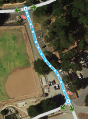
The Waze map should not be an exact copy of the satelite view. The Waze map should be as simple as possible, so that the navigation instructions are correct and the map should be easy to read while driving. Almost everybody tends to make the map an accurate copy of the satelite view, this is not what you should do. This means even that sometimes roads or parts of roads are not drawn or different then in the satelite view. An other pitfall with the satelite view is that they can be outdated. Also you can't see everything from above. For example a road in the woods is probably not vissible on the satelite view. Use the satelite view as a source, but not a a goal to copy. In case the road is mapped different then the view consult the previous editor or the area manager. | |||
[[File:TryingTooHard.png|thumb|left|320px|''' | == Too much geometry nodes== | ||
[[File:TryingTooHard_fixed.jpg|thumb|right|320px|''' | Too much geometry points can slow down the build of your screen and also it makes a segment harder to maintain. For those reasons we use as less nodes as possible. Even if that means that a road in Waze does not exactly follow the road in the satelite view. When you see that a segment had too much nodes, please remove them by hoover with your mouse over the nodes and press 'd'. | ||
<gallery> | |||
File:GeometryNodes_excessive.png|<small><span style="color:#FF0000"><translate>Too much geometry nodes (13 nodes)</translate></span></small> | |||
File:GeometryNodes_efficient.png|<small><span style="color:#008000"><translate>This is efficiënt (3 nodes)</translate></span></small> | |||
</gallery> | |||
<gallery> | |||
File:WME geometry corner toomanynodes.PNG|<small><span style="color:#FF0000"><translate>Too much geometry nodes</translate></span></small> | |||
File:WME geometry cornerminimumnodes.PNG|<small><span style="color:#008000"><translate>This give excelent navigation instructions</translate></span></small> | |||
File:WME geometry cornerreducednodes.PNG|<small><span style="color:#008000"><translate>If you prefer rounded corners you can use this as the intermediate solution</translate></span></small> | |||
</gallery> | |||
For more information see [https://wiki.waze.com/wiki/Benelux_WME_Quick-Start#Create_a_Road Create a road]. | |||
==Simplify a cross section== | |||
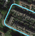
[[File:TryingTooHard.png|thumb|left|320px|'''The actual situation of the cross section.''' When you draw in this example the roads exactly as the actual situation you will lots of segments and junctions. Which result in a lot of maintenance. Also the driver will get lots of navigation instructions, where one instruction, e.g. turn left, should be sufficient and much clearer.]] | |||
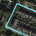
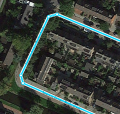
[[File:TryingTooHard_fixed.jpg|thumb|right|320px|'''This is the prefered way to draw this cross section.''' This way the driver gets only one navigation instruction and also the map is easy and quick to read also on a small screen.]] | |||
{{clear}} | {{clear}} | ||
<div style="text-align: right; direction: ltr; margin-left: 1em;">[[#TOC|<small>'' | More examples of drawing complex situations can be found in [https://wiki.waze.com/wiki/Benelux_Advanced_Guide#KISS_-_Keep_It_Stupidly_Simple Advance guide]. <!-- Deze link is naar het Engels, maar de tekst is dus nog niet vertaald. --> | ||
<div style="text-align: right; direction: ltr; margin-left: 1em;">[[#TOC|<small>''go back to the table of content''</small>]]</div> | |||
==Wegtypen== | ==Wegtypen== | ||
Revision as of 09:13, 10 April 2015

| This new page is currently undergoing modifications. The information presented should be considered a draft, not yet ready for use. This content is open to changes from anyone during construction. If you would like to make changes or have questions, please send a private message to this user. |
Common errors: Improve your skills!
Introduction
Welcome to this Wiki page. You probably got the advice from another editor to read this page, or a specific part of this page. This advice is given to increase the quality of your edits. The edits for which you were referenced might have been deleted or adjusted in the mean while. This might be unhandy, because you miss a specific example. However, realize that the main goal of this advice is to improve your editing skills. If there is no specific subject why you are reading this Wiki page, just consume the information and when you need it, come back to the specific section of your need. Do not try to understand this whole Wiki page with all the details in once, for it might be overwhelming.
You are not the only editor who makes mistakes. All editors made mistakes and also all, now and then, still do. That's the way most people learn. And most of the times it are not even mistakes. The editing guidelines have developed over several years. So, something that was according to the regulations a year ago, might today be ready for improvement.
This Wiki page is not supposed to be a full manual of how to edit the Waze Map. It is an overview of subjects that are often confusing for starting editors, because they did not know the guidelines yet and their own logic tells them differently. This is not strange, because many of the guidelines have changed over the years and if you don't know the history, you don't always see the logic. All (starting) editors had this issue. And because guidelines are still changing and will keep changing, this will also happen to more experienced editors. In addition, the technical working of Waze changes often.
On this Wiki page, we have tried to combine technical knowledge of Waze with the users guidelines in the BeNeLux. To keep duplicate texts to a minimum, we also reference to other Wiki pages.
The best advice we can give to starting editors is to just start and make use of the community. Things will become clear in the process of learning. If something is unclear to you, first try to find it in one of the Wiki pages {overzicht van wiki pagina's, nog te maken}. If you can't find it, [ask your community]; Other editors are very willing to help. While reading the information in the Wiki or getting it from other editors, please keep in mind that, like in real live, also in Waze it is not always black and white. That is why we say we don't have rules or regulations, but guidelines. You may receive several opinions from two experienced editors and both can be correct, although a different interpretation. In addition, exceptions to guidelines are always possible and no problem, provided you have good arguments.
The most made mistakes are because of the overall principle, this is 'Waze is not a topographic map, but a navigation tool'. Many starting editors try to make the map in Waze an exact copy of the actual situation. Roads are split, add pedestrian boarding walks and cycle paths, draw perfect rounded corners and area places are exactly drawn. The actual goal of Waze is to get the best instructions. The less detail on the map, the easier and faster a map can be interpreted, during driving. Especially on small smartphone screens.
An other reason to keep the detail as low as possible is speed. The less details the less bandwidth the downloading of the map requires. Also the less junctions there are, the faster the route calculation is. The number of junctions that Waze handle in one route is limited. So keeping the number of junctions as low as possible, the longer a route can become.
To help you Waze has created a number guidelines. That is what this page is about.
Editing mistakes are inevitable
Everybody, without the need of any prior knowledge or practice, can start editing the Waze map. Therefore, Waze accepts the risk that users make edits that seems logical to them, but lead to undesired results. The Waze community is enthousiastic and active, so the mistake will quickly be noticed. A more experienced editor will contact you to correct the mistake or do the correction himself. It is not meant as criticism, but an encouragement to learn more about editing.
Mistakes are often the result of a misunderstood or unknown guideline, or a lack of technical knowledge. In fact, there is only one true "mistake" you can make, which is withholding from communication with other editors.
Make sure that other editors can contact you
The only true mistake you can make as an editor, is being unreachable to other editors. If editors remark your edits with an undesired result, or if they don't understand the reason why you made this edit, they will try to contact you. They want to increase the quality of the map and meanwhile help you to become a better editor. If other editors cannot reach you, they cannot help you! Moreover, they will probably change your edits according to their own interpretation of the situation.
Therefore, make sure that you can receive e-mails from Waze by providing a valid mail address. Ccheck your mailbox regularly. Also check whether e-mails from Waze are not delivered to your spam- or junkfolder. You might want to make a filter to move the e-mails from Waze to a specific folder, or even create a separate mailbox for Waze. If needed, Adjust your Waze settings.
Communication
How can I contact Waze? Where can I find more information? Where can I post my questions. The local champs are responsible of the goings of your local community. Please contact one of more of them for questions or assistance.
Forum
The forum of your own country is a good starting point for finding more information. You can meet other editors. Read the latest information. Learn from questions of other editors. Or ask a question yourself. You can login using your standard login and password of Waze, which you also use in the app and the editor. In the forum you can also make use Private Messages (PM), this is a kind of inbox, like your e-mail. When you receive a PM you will also receive a regular e-mail to inform you. Also if you have installed the 'WME toolbox' you get a message in the editor of new PM's. How you can handle your PM's you can read here.
Chat
When you are editing you can directly request help in WME chat. When asking for help you can see the level of the colleague you are talking to. Please keep in mind that most editors are willing to help, but not all of them have the technical knowledge or editing experience to give you the best answer. Besides the Chat, which does not work always as desired, we also have Hangouts and Slack. Most editors, especially the higher level ones, have an account on both Hangouts and Slack.
Hangouts
For Hangouts you need a Google account and install the extension in Chrome and/or an app on your smart phone or tablet. Hangouts works with groups and also you can contact users individually. For Waze Benelux several groups are available. There is one per country and one per area (Provence) of the tree countries. If you want to be added in one of the groups send your Google account to your mentor or another L4+ editor.
Slack
If you want to use Slack your first need to request an account on slack.com and them when you logged in type '-invite wazebenelux' and you should receive a link to proceed. In Slack there are Channels, Direct Messages (DM) and Private groups. The channels are split up by subject, please try to use the correct Channel for your question or remark.
Wiki
A lot of information is available in the Wiki of your country. There is one Wiki for the Benelux, of course representing the countries Belgium, Luxembourg and the Netherlands. At the moment a group of people is bringing the Benelux Wiki up-to-date again. The Wiki can be maintained by everybody. Because the are guidelines applying to the whole of the Benelux changes need to be approved in the forum by one of the local champs. In this forum everybody can also do suggestions for new/adjusted guidelines or textual improvements.
At the bottom of each page you can see the date the page is updated. If this is longer than half a year ago please take into consideration that the information is outdated. So if you have seen newer guidelines or technical information in one of the other communication channels, assume that that is more up-to-date. When a Wiki page is available in an other language you can select that at the top of the page. Please keep in mind that the pages are maintained per language. So it is possible that the information is not exactly the same. Also an other language can be older or newer.
A good start with the Wiki is the Benelux Beginnersgids.
The principles of Waze
Many misunderstandings have their origin in the fact that the fundamental principles of Waze are not clear. Waze is developed for motor vehicles and should not be used for other means of transport, like pedestrians, pedal cyclists, public transport or taxi's. you should also not use it for personal favourite places, historic railways and illegal shortcuts.
User friendliness
Waze offers drivers a navigation system based on a map that is easily to see on a small screen. Supported with clear and understandable verbal instructions at the moments it is needed.
Simplicity
A lot of things are not added to the map, because we want the map to be as simple and efficient as possible. Unless a object contributes to the navigation as a landmark, it should not be added. Only roads where you can drive with a normal car should be added to the map. When you want to be able to navigate easily to a place (e.g. a supermarket) you can add it as a point place. This way it won't be visible, but you can navigate to it, without knowing the address. Adding too much objects make the map less easier to read and also increase the workload of maintaining the map. If you are not sure whether to add a specific object, please contact the area or region manager.
Cautious
All segments contain information that is used to calculate the optimal route, like average historic speed or average delay at a junction. When you are deleting that segment, you will also delete this information. So be cautious with that. You can better adjust existing segment, then delete the old one and create a new one.
An other reason to be cautious with deleting segments is that an other editor had a reason to add it. And when he or she sees that the segment is removed again without getting a notice that can be demotivating. Everybody can make a mistake or guidelines could have been changed over time. Therefore it is better to consult the editor who added the segment then to change the segment yourself.
Locked segments
To protect the map segments have a lock level based on the importance of the road. These roads can only be edited by very experienced editors. Connecting roads and high volume roads have a higher lock level then streets. Most editing options are not available, but when you succeed to edit such a segment you can't save your changes. When you try to connect a segment to a road with a higher lock level you will get an not connected segment.
When you want to make an edit on a segment with a higher lock level, you can request a temporary decrease of the lock level. You can ask this to your area or region manager or the last editor via a Direct or Personal message via one of the Communication methods we have. Please provide a permalink where you have selected all segments where you are requesting the temporary decrease for. You van also post this request in this forum. Before you do please read first this topic.
Common functional mistakes
Incorrect or incomplete data can have a negative effect on the navigation or make it even impossible to navigate to a specific location. We call these functional mistakes and they should be corrected as soon as possible. Functional mistakes are, if noticed by an other editor, often directly corrected, because of the great impact.
Red roads


When a road does not have a city- or street name it will be red in the WME and it won't be drawn on the map or used for navigation. These roads can originate from
- Paving roads, who have not been confirmed in the WME.
- an editor added a road, but forgot to give it a name.
You fill in these two names by selecting the segment or segments and click 'Edit' on the top left of the screen. If you don't know the name of the street and/or city name check None.
Never delete a segment without first consult the editor who added it. If you think the segment is an improvement to the map, fill in the missing data. Also check the junction arrows, because when an editor has forgotten to fill in the name, most of the time the junction arrows are also not set correctly.
Here you can find more information: Create a road.
Junction Arrows (JA)
Junction arrows used to be called Turn Restrictions. Junction Arrows are the red, green en orange arrows when you select a segment and they control which turns are allowed. Green is allowed, red is not allowed and orange is partial restricted, based on time. You can limit based on type of vehicle, but that does not work in the route calculation.


When you change the driving direction of a segment always also check the junction arrows. The WME does not adjust them automatically based on the driving direction. The quickest way to correct hem is to select the junction and press q and w or click on the button 'Allow all turns'. While creating a new road by default all TR's are red. In the advanced settings of the editor check the option 'Draw new roads with all turns allowed'. If you select this option, it is advised to also check the option 'Draw new roads as two-way'.
An easy way to check incorrect red junction arrows is Ctrl-Z. This will show all the red arrows in the area on your screen, also for the not selected segments. Of course these are not all incorrect, but you can check them. It is advised to before you do the correction, you press Ctrl-Z again and select the segment with the red arrow. Otherwise you can not see which segment has the red arrow.
Disconnected segments
Just because segments appear to intersect on your display, they sometimes do not for real. The fasted way to check this, is to select one of the segments. When you don't see the Junction Arrow(s) light up, it is not connected.


When a road should be connected, please check the Junction Arrows. If it is not connected, move the end node away from where it should connect, and drop it somewhere else. Than pick it up again and drag it to where you want the junction to be. WME now automatically creates a junction. Again, check the Junction Arrows.
If you cannot connect a segment using the above described method, one of the segments could have a lock level higher than your editing level. In that case you cannot solve this functional mistake yourself and you might want to ask for an unlock. If the segment is a pedestrian boardwalk, check whether this segment should be connected anyway on the Benelux Pedestrian Boardwalks page. More information is to be found on connecting roads.
Incorrect use of roundabouts
When approaching a roundabout specific instructions are given. For a standard roundabout (4 exits) the instruction is 'Turn left at the roundabout'. For other roundabouts the instruction will be 'Take the third exit at the roundabout'. If these instructions are not correct for the situation, please don't use a roundabout. A dead-end street should not have a roundabout at the end. If there is no road sign for a roundabout don't use a roundabout. This will give incorrect instructions, where a driver thinks he is approaching a roundabout, when this is not the case. for more information about how to create a roundabout see Quick Start Guide.
![]() ToDo: Translate into English
ToDo: Translate into English
Private access roads that distort routing
Many new editors enthusiastic start mapping all small streets, alleys, driveways, parking lot roads, etcetera. They think if you can drive on it, you can map it. But this can have some negative effects. Of course it means a lot of extra data (bandwidth) and extra calculations. Also it can make the map less clear on small screens. But the biggest disadvantage is that is can distort the routing.
The way Waze works is that is it finds your destination based on GPS coordinates. In a lot of cases from Google. Based on those coordinates it pins your destination. Then it looks for the closed drive-able road, without looking at the name of that road. So that means if the driveway of the rear neighbors is closer to the pin of your destination then you will be lead to the wrong road. And when this is a long road, it can be far of from your actual destination.

Too much or incorrect geometry noded
Too much geometry points can slow down the refresh of your screen and also it makes a segment harder to maintain. For those reasons we use a less nodes as possible. Even if that means that a road in Waze does not exactly follow the road in the satelite view. When you see that a segment had too much nodes, please remove them by hoover with your mouse over the nodes and press 'd'.
-
Too much geometry nodes (13 nodes)
-

This is efficiënt (3 nodes)


-
Too much geometry nodes
-
This give excelent navigation instructions
-
If you prefer rounded corners you can use this as the intermediate solution


For more information see Create a road.
<!== Ik heb ervoor gekozen om dit stuk niet te vertalen, omdat we dit volgens mij in de inleiding moeten opnemen/integreren. ==>
Onderlinge afspraken
Omdat elk land andere wetten en gebruiken kent, worden ook binnen de Waze gemeenschap in elk land verschillende afspraken gemaakt. Daarnaast worden ook afspraken gemaakt tussen de gebruikers van Waze in verschillende landen. Dit zijn afspraken die niet altijd even logisch lijken als je er voor het eerst mee te maken krijgt, maar die door de jaren heen zijn ontstaan om de beste navigatie met zo min mogelijke data in jouw omgeving te genereren.
Heb je edits gemaakt die de afspraken niet volgen, dan kan je worden gevraagd om deze bij te werken; Zelfs al lijken ze niet fout in jouw ogen, lees de informatie en verbeter je vaardigheden als Waze editor in jouw omgeving. Zo kun je ook een voorbeeld zijn voor anderen en vermijden we problemen.
Het kan intimiderend zijn om de hele lijst in één keer door te lezen. Wees gerust, er wordt echt niet verwacht dat je meteen alles goed doet. Begin gewoon. Dat kun je het beste doen door je eerst de kaartbewerking eigen te maken waarvoor je deze link hebt gekregen. Dit artikel bevat ook een lijst van bewerkingen die over het algemeen veilig en gemakkelijk zijn voor beginnende editors.
The relation between the satelite view and the map
The Waze map should not be an exact copy of the satelite view. The Waze map should be as simple as possible, so that the navigation instructions are correct and the map should be easy to read while driving. Almost everybody tends to make the map an accurate copy of the satelite view, this is not what you should do. This means even that sometimes roads or parts of roads are not drawn or different then in the satelite view. An other pitfall with the satelite view is that they can be outdated. Also you can't see everything from above. For example a road in the woods is probably not vissible on the satelite view. Use the satelite view as a source, but not a a goal to copy. In case the road is mapped different then the view consult the previous editor or the area manager.
Too much geometry nodes
Too much geometry points can slow down the build of your screen and also it makes a segment harder to maintain. For those reasons we use as less nodes as possible. Even if that means that a road in Waze does not exactly follow the road in the satelite view. When you see that a segment had too much nodes, please remove them by hoover with your mouse over the nodes and press 'd'.
-
Too much geometry nodes (13 nodes)
-
This is efficiënt (3 nodes)
-
Too much geometry nodes
-
This give excelent navigation instructions
-
If you prefer rounded corners you can use this as the intermediate solution
For more information see Create a road.
Simplify a cross section


More examples of drawing complex situations can be found in Advance guide.
Wegtypen
Het gebeurt vaak dat beginnende editors het wegtype van een segment willen veranderen. Zoals een spoorlijn, die in de BeNeLux als “Walking Trail” wordt afgebeeld, terwijl de optie “Railroad” ook in de lijst staat. Wegtypen hebben verschillende betekenis met verschillende functies, die ook in verschillende landen anders worden gebruikt. Zo leidden spoorlijnen (Railroad) in het verleden tot problemen op de kaart en in de navigatie. Daarom is in de BeNeLux gekozen om ze aan te leggen als “walking trail” (en op hoog niveau te locken). Sommige wegtypen worden helemaal niet meer gebruikt (Zie wegtype voor een uitgebreid overzicht).
Snelweg
Ondanks dat de naam anders doet vermoeden, is een snelweg meestal geen snelweg zoals we die in het wegennet kennen. Voor de Waze kaart betekent het alleen maar dat deze weg meer verkeer draagt dan de nabijgelegen alternatieven. Zo kan een nauwelijks onderhouden, één-baans landweggetje als "Minor Highway" zijn getypeerd, en een doorgaande straat in een klein dorp als "Major Highway". Het beoordelen van een weg door zijn betekenis ten opzichte van nabijgelegen alternatieven te bekijken, heet "functionele classificatie", ofwel FC. De meeste segmenten die voor doorgaand verkeer zorgen krijgen dan ook een vergrendeling (lock) krijgen. Aanpassingen aan zulke wegen kunnen alleen door editors gedaan worden van dezelfde of een hogere rang dan het locklevel. Denk je dat een aanpassing nodig is, overleg dan met een ervaren editor met een hoog genoeg level, of plaats een vraag op het forum Kaartaanpassingen (NL).
Voetgangers- en fietspaden
Omdat Waze alleen gebruikt wordt voor autonavigatie laten we in het kader van een zo simpel mogelijk kaart zoveel mogelijk niet-navigeerbare delen weg, tenzij ze belangrijk zijn bij het navigeren (als oriëntatiepunt bijv.). Als we besluiten ze toch toe te voegen, dan gebruiken we “Pedestrian Boardwalk” als wegtype met rijrichting onbekend en sluiten we ze in principe niet aan op de navigeerbare wegen. Walking Trails worden in de Benelux niet gebruikt voor wandelpaden, maar voor openbaar vervoer. Zie de Wiki voor uitgebreide informatie.
Parkeerplaatsen


Ook Parkeerplaatsen worden eenvoudig maar effectief ingetekend; Alleen de hoogst noodzakelijke wegen om er op en er af te rijden worden gebruikt. Bij zeer grote parkeerplaatsen worden ook de onderlinge verbindingswegen ingetekend. De wegen op Parkeerplaatsen krijgen in principe geen straatnaam (kruis "geen" aan achter de straatnaam). Zie Parking Lot Roads voor meer informatie.
Wegen splitsen
Als een een weg in werkelijkheid is verdeeld door een middenberm, hoeft dat nog geen reden te zijn om deze ook te splitsen in WME! Splitsen van wegen draagt niet bij aan het KISS-principe en kan zelfs problemen veroorzaken. Denk je dat een weg toch gesplitst zou moeten worden, stem dit dan af met de lokale Area Manager of leg het voor aan een ervaren editor via het forum of chat. Volg de Best map editing practice. Het ongedaan maken van gesplitste wegen kost minstens net zoveel moeite als het splitsen zelf.
Update Requests (UR´s)


Bij het melden van een kaartprobleem hebben bestuurders zelden voldoende tijd om het probleem duidelijk te maken. Daarom heeft Waze de mogelijkheid ontwikkeld om bij de Update Request (UR) een gesprek te starten.
Het behandelen van UR’s vraagt de nodige aandacht. De melder probeert te helpen door een probleem melden. Door het probleem zo goed mogelijk op te lossen, kunnen we Waze steeds beter aanpassen aan de verwachtingen van alle gebruikers. We nemen dus alle meldingen serieus en ze worden nooit zomaar gesloten. Zeker als een andere editor al met de melding aan de slag is, geldt dat je de UR-etiquette (Engels) in acht houdt. In het kort:

- Als je een UR kunt oplossen, leg dan in het gesprek uit wat je hebt gedaan. De melder voelt zich serieus genomen en hier leren ook andere editors van. Bovendien kan het handige informatie zijn voor het oplossen van andere meldingen in de buurt.
- Als de melding onduidelijk is, vraag dan op een beleefde manier om meer informatie
- Als er al een gesprek gaande is, sluit dan niet zelf de melding zonder overleg met de eerste editor die de UR behandelt!
- Als er al om meer informatie is gevraagd en er komt geen reactie binnen 5 dagen, dan kun je een herinnering plaatsen. Het kan zijn dat de editor hem uit het oog is verloren. Wat je ook vaak ziet is dat een melder pas na een herinnering antwoord geeft.
- Gebeurt er daarna nog 2 dagen niets meer en het is een vage melding, sluit hem dan af als niet geïdentificeerd, met een opmerking in het gesprek.
Voorbeeldreacties vind je in het script WME UR Comments. Voor meer informatie over dit onderwerp, zie de uitgebreide beschrijving in de Amerikaanse Wiki pagina over Update Requests.
Wat kan ik wel bewerken?
Overal waar je hebt gereden mag je editen. In zwaar bevolkte gebieden zullen er veel editors zijn en kun je er vanuit gaan dat de kaart al op behoorlijk niveau is. Je kunt er misschien overtollige geometriepunten verwijderen, kleine afwijkingen corrigeren en afslaginstructies controleren. Als je andere dingen wil editen, dan kun je je energie het beste richten op de minder drukke gebieden. In afgelegen gebieden is vaak weinig aandacht geweest voor verbetering van de kaart sinds de oorspronkelijke basis- import. Je ziet er vaak een overvloed aan wegen zonder naam, onverharde wegen die ten onrechte ingesteld zijn als gewone straat, onbekende rijrichting etc.. Door ook deze gebieden op een hoger niveau te krijgen wordt Waze steeds betrouwbaarder.
Mocht je toch in een zwaar bewerkt gebied gaan editen, wees je er dan van bewust dat er zich al veel editors hebben bezig gehouden met de kaart. Dingen die misschien op het eerste gezicht niet juist lijken, kunnen bewust zo zijn ingetekend, na zorgvuldige overweging van de basisprincipes en werking van Waze. Wees voorzichtig met het wijzigen van het werk van andere editors. Vraag liever even na of jouw idee klopt (via het forum, chat of een PM aan de laatste editor).
Constructieve werkzaamheden voor startende editors
- Lees de Quick-Start!
- Controleer de straatnamen op spelling en afkorting. Kijk of stadsnamen consistent zijn binnen de grenzen van de gemeenten. Gebruik daarvoor de beschikbare gegevens van bronnen die gebruikte mogen worden.
![]() ToDo: toevoegen link voor meer info
ToDo: toevoegen link voor meer info
- Controleer de rijrichting van de wegen, mbv streetview en beschikbare bronnen. Bedenkt wel, indien er recente edits hebben plaatsgevonden, kan het zijn dat de gegevens in Waze nieuwer zijn dan bijv. streetview.
- Controleer de afslaginstructies. Tip: gebruik ⇧ Shift+z hiervoor.
- Voeg recent aangelegde wegen toe die nog niet staan aangegeven op de kaarten, zoals een nieuwe wijk. Lees eerst meer over een straat aanleggen
- Informeer Area Managers en/of senior editors over problemen.
- Controleer toegevoegde Plaatsen in jouw omgeving; is de juiste categorie toegewezen, klopt de naam en locatie etc.. Controleer ook of het een Area of Punt moet zijn.
- Hou de wegwerkzaamheden in de buurt bij. Hoe je deze kunt verwerken lees je in het forumtopic mogelijkheden voor afsluitingen.
- Help mee om de Wiki begrijpelijk en up to date te houden. Zie het forum.
- Help mee met het vertalen van Waze teksten. Een uitleg staat in de Benelux Wiki Guide. Meld je graag ook aan in het forum en/of bij Slack©, waar we een apart onderdeel voor Wiki-Benelux hebben. Daar bespreken we altijd eerst de voorgestelde wijzigingen.
Risicovolle werkzaamheden voor startende editors
Tenzij je samenwerkt met een ervaren editor, wees dan terughoudend met de volgende activiteiten:
- Verwijder geen straten of delen van straten zonder overleg. Dit verwijdert namelijk ook de verkeersinformatie die daar bij hoort.
- Verander geen wegen die aangesloten zijn op vergrendelde segmenten.
- Geen wegen splitsen, al zijn het in het echt meer rijstroken.
- Voeg geen niet-berijdbare wegen toe, zoals wandel- en fietspaden, spoorwegen, start- en landingsbanen, busbanen, etc.. Het lijkt misschien onschuldig, maar door de manier waarop Waze ze implementeert kunnen ze de navigatie negatief beïnvloeden en zelfs voor verkeerde routes zorgen.
- Verander nooit het wegtype, zoals Minor Highway, en Major Highway. Ook dit beïnvloedt de navigatie sterk. Zie Misverstand mbt het wegtype "snelweg" voor meer informatie.
- Vermijd het toevoegen van wegen op (risico op overdrijven waardoor de kaart onduidelijk wordt, op het verstoren van de routing naar nabijgelegen bestemmingen, het creëren van foutieve afslaginstructies, of de kans op niet aangesloten segmenten).
![]() ToDo: toevoegen info parkeerplaatsen
ToDo: toevoegen info parkeerplaatsen
- Verander geen grote kruispunten, opritten of snelwegen (waarbij je zeer waarschijnlijk vergrendelde segmenten zult tegenkomen). Er is een groot risico op verstoring van belangrijke doorgaande routes.
- Het bewerken of zomaar sluiten van de door gebruikers gemelde kaartproblemen (Update Requests-URs). Dit vereist uitgebreide kennis van de UR etiquette en van de (on)mogelijkheden van Waze. Je kunt uiteraard wel suggesties geven in de conversatie.
Dank voor je aandacht!
| Benelux | Community | Roads | Places | Forum | WME |