(→Raid Areas: added image map) |
|||
| (29 intermediate revisions by 3 users not shown) | |||
| Line 2: | Line 2: | ||
<big><center>'''MegaMapRaid! Venezuela 2015'''</center></big> | <big><center>'''MegaMapRaid! Venezuela 2015'''</center></big> | ||
{{mbox|type=information|text= | {{mbox|type=information|text= | ||
'''<translate>Please see [[Venezuela| | '''<translate>Please see the [[Venezuela|Venezuelan wiki page]] (Spanish) for more information on editing in Venezuela.</translate>''' | ||
{{#ifexpr:{{#time:xNU|2015-11-26T0430}}>{{#time:xNU|}} <!-- registration end date 24:00,midnight 26-11-15 HLV--> | {{#ifexpr:{{#time:xNU|2015-11-26T0430}}>{{#time:xNU|}} <!-- registration end date 24:00,midnight 26-11-15 HLV--> | ||
| '''<translate>Registration for MegaMapRaid Venezuela 2015 is open now! Please fill in this [https://docs.google.com/forms/d/1qy_GVgVTNZ2R0uVep-wsXXHrQvnLx3PrlVM8OXt7rEY/viewform form] before 2015-11-26 midnight, Venezuelan time | | '''<translate>Registration for MegaMapRaid Venezuela 2015 is open now! Please fill in this [https://docs.google.com/forms/d/1qy_GVgVTNZ2R0uVep-wsXXHrQvnLx3PrlVM8OXt7rEY/viewform form] before 2015-11-26 midnight, Venezuelan time, which is 2015-11-27 04:30 UTC.''' | ||
|Registration for the MapRaid is closed. To learn about future MapRaids, please follow the [http://wazemapraid.slack.com MapRaid Slack]. If you are not a member, you may [http://bit.ly/GetWazeSlackInvite request an invitation].</translate>}} | |Registration for the MapRaid is closed. To learn about future MapRaids, please follow the [http://wazemapraid.slack.com MapRaid Slack]. If you are not a member, you may [http://bit.ly/GetWazeSlackInvite request an invitation].</translate>}} | ||
}} | }} | ||
| Line 12: | Line 12: | ||
<translate> | <translate> | ||
== ¡Welcome to MMR Venezuela 2015! == | == ¡Welcome to MMR Venezuela 2015! == | ||
There will be 6 teams in this Mapraid. Each team has rank 4 or 5 editor who will provide guidance on the assigned objectives. | There will be 6 teams in this Mapraid. Each team has a rank 4 or 5 editor who will provide guidance on the assigned objectives. | ||
== Mission == | == Mission == | ||
| Line 19: | Line 19: | ||
* Check road connectivity, direction and house numbers. | * Check road connectivity, direction and house numbers. | ||
** We must name the roads in the correct format. | ** We must name the roads in the correct format. Add house numbers if you know them. Please go to the [[Venezuela|Wiki page of Venezuela]] (Spanish) for more details. | ||
* Be careful when you delete a segment | * Be careful when you delete a segment. If you have any doubts, please contact your group leader. Delete segments only when you are absolutely sure that they do not exist. | ||
* If part of a road is a bridge, add it. See the "elevation" (link) section of this page. | * If part of a road is a bridge, add it. See the "elevation" (link) section of this page. | ||
* Add the PLR (Parking Lot Roads) of the shopping malls and drive-thrus. | * Add the PLR (Parking Lot Roads) of the shopping malls and drive-thrus. | ||
| Line 40: | Line 40: | ||
== {{red|¡Important!}}== | == {{red|¡Important!}}== | ||
'''Please do not''' lower the road type of any segment without first consulting a local editor. You may raise the road type to meet the road type guidelines. | '''Please do not''' lower the road type of any segment without first consulting a local editor. You may raise the road type to meet the road type guidelines of the country. | ||
'''{{red | PLEASE DO NOT MAKE | '''{{red | PLEASE DO NOT MAKE MASS EDITS !!}}''' Please do not make edits affecting a large number of segments simultaneously. Historical values stored in each segment are very valuable in the process of resolving URs. Mass edits also massively erase those values permanently. We ask that all necessary bulk edits are reported to the raid hosts, in order to be reviewed and implemented by the local team after the end of the Mega Map Raid, including the edits made with the "Select Entire Street" feature. | ||
'''''Be aware that we will monitor edits, so avoid unnecessary edits and hunting for points. Sanctions are strict, being banned for this and future MR and MMR.''''' | '''''Be aware that we will monitor edits, so avoid unnecessary edits and hunting for points. Sanctions are strict, being banned for this and future MR and MMR.''''' | ||
Don't come later and say "I didn't know" or "I did not intend to damage the map". If you are using | Don't come later and say "I didn't know" or "I did not intend to damage the map". If you are using a tool or script, you are fully responsible for its use and its consequences. There will be no second chances. | ||
You can go to the script's forum topic and read all about what they do. | You can go to the script's forum topic and read all about what they do. | ||
# | # Lack of information is no excuse. | ||
# If you are unsure about something, please ask. | # If you are unsure about something, please ask. | ||
# Check and triple check. | # Check and triple check. | ||
# We have great leaders here who can help you. | # We have great leaders here who can help you. | ||
# Let's make sure we do it right the first time, and set a great example for the rest of the world. | # Let's make sure we do it right the first time, and set a great example for the rest of the world. | ||
There is no problem if you use scripts to help with your editing. But please | There is no problem if you use scripts to help with your editing. But please note that you are responsible if the use of a script causes problems or damage to the map. Please make sure that you understand completely the features you are using. You will be held accountable for any side effects. | ||
''' Locked segments? '''<br /> | ''' Locked segments? '''<br /> | ||
| Line 59: | Line 59: | ||
'''Difficult-to-spot geometry nodes'''<br /> | '''Difficult-to-spot geometry nodes'''<br /> | ||
We often use "doglegs" to force a '"turn" instruction instead of "keep" or "exit". his involves carefully placing the node very close to the intersection to achieve the correct angle, so it will be necessary to zoom in to see them. If you make a change, be sure to leave them with the same angle. | |||
'''{{red|City boundaries | '''{{red|City boundaries}}'''.<br /> | ||
Improving the city boundaries is | Improving the city boundaries is not a priority. Leave the City/Town field as you find it. When adding new streets, add a city only if you are 100% sure which city it belongs to. In rural areas, leave the city field empty (check the ''None'' box). The same rule applies to all major roads that connect cities (highway/Troncal). | ||
== Local Guide == | == Local Guide == | ||
| Line 68: | Line 68: | ||
=== Road Types === | === Road Types === | ||
The current rules are rather new to our country, and many areas still need to upgrade for route continuity. Therefore, do not decrease road types without consulting a local editor. Also, all unpaved roads should be classified as "dirt road / 4x4".<br /> | The current rules are rather new to our country, and many areas still need to upgrade for route continuity. Therefore, do not decrease road types without consulting a local editor. Road types are explained on [[Venezuela#Clasificaci.C3.B3n_de_v.C3.ADas|the Venezuelan wiki page]] (Spanish). Also, all unpaved roads should be classified as "dirt road / 4x4".<br /> | ||
If you find an area that seems unfinished, please ask a local editor to look at it before you start editing. | If you find an area that seems unfinished, please ask a local editor to look at it before you start editing. | ||
</translate> | </translate> | ||
{{Locking Standard | {{Locking Standard|lede=In our country we have a minimum locking standard for segments according to road type. Any road should be locked to at least the locking level in the table below. Roads that need more protection because of special situations (construction, inaccurate images, complicated design, frequent editing errors) may be locked higher. Do not leave roads locked lower than the minimum values below. | ||
|caption=Minimum Lock Level|title=<translate>Urban Zone</translate>|Fwy=5|Ramp=4|MH=5|mH=3|PS=2|Street=1|title2=<translate>Rural Zone</translate>|Fwy2=5|Ramp2=4|MH2=4|mH2=2|PS2=1|Street2=1}} | |||
<translate> | <translate> | ||
| Line 81: | Line 82: | ||
=== Elevation === | === Elevation === | ||
In Venezuela, elevation levels are like they are in | In Venezuela, elevation levels are like they are in reality. This sometimes requires the use of extra segments. It makes the LiveMap looks more real too. More importantly, it will be easier to close a bridge or tunnel without affecting traffic into nearby homes or businesses. | ||
If you see any elevation you think is abnormal, but do not know the area, contact a Champ or a local editor. If you see a bridge with the same elevation as the segments that precede and follow, please cut the segment | If you see any elevation you think is abnormal, but do not know the area, contact a Champ or a local editor. If you see a bridge with the same elevation as the segments that precede and follow, please cut the bridge segment at the beginning and end of the bridge. Then, raise the elevation of the bridge by 1 (+1). | ||
</translate> | </translate> | ||
[[File:MXPuente.png|550px|center|border]] | [[File:MXPuente.png|550px|center|border]] | ||
<translate> | <translate> | ||
=== Editing Places === | === Editing Places === | ||
Map editors and trusted App users both make mistakes or omit information while editing places. Incorrect names and categories, incorrect or missing addresses (all businesses should have an address!), incorrect location, and photos that don't match are all over the map. You must use the '' 'Place Browser [https://w-tools.org/PlaceBrowser?group=MegaMapRaidVenezuela Place Browser]' '' to correct these errors. | Map editors and trusted App users both make mistakes or omit information while editing places. Incorrect names and categories, incorrect or missing addresses (all businesses should have an address!), incorrect location, and photos that don't match are all over the map. You must use the '' 'Place Browser [https://w-tools.org/PlaceBrowser?group=MegaMapRaidVenezuela Place Browser]' '' to correct these errors. | ||
| Line 94: | Line 96: | ||
Examples: | Examples: | ||
;If you are inside a Mall, add the Mall name to the retail. | |||
:For example: '''Mc Donalds - CC Sambil Maracaibo'''. | |||
;If not within a Mall, the name gives the location of that branch of a chain. | |||
:For example: '''Farmatodo - Alta Vista'''. | |||
To know whether a place should be point or area, check the [[places | places]] page. | |||
<!--[[Lugares|Lugares ]]--> | |||
To know whether a place should be point or area, check [[places | places]]<!--[[Lugares|Lugares ]]--> | |||
==== Gas Stations ==== | ==== Gas Stations ==== | ||
Check if a gas station has the correct details. The name format is E/S XXXX, where XXXX represents the name of the Gas station.<br /> | |||
When | When gas stations have an interior street, it must be a PLR (Parking Lot Road).<br /> | ||
'''{{red |DO NOT DELETE GAS STATION PLRs}}'''. | |||
When checked and complete, gas stations in Venezuela should be locked to level 4. | |||
If you find any problems with a gas station, contact a local editor. | |||
If | === Left turns at intersections without traffic signs=== | ||
If there are no traffic signs, and the road does not have a solid middle line: left turns are always allowed. | |||
=== | === Drawing two-way streets === | ||
In the | In normal two-way streets (double lanes, not divided) with no exclusive lanes between the directions, with simple geometries and no reversible sections, the logic to draw them is as shown in the following flow chart. | ||
* If there is no median, use a 2-way segment | |||
* If there is a median wider than 12 meters, use a divided roadway | |||
* If there is a median less than 12 meters wide, | |||
** but there is a special lane between the two directions (bicycle lane, emergency vehicle lane, ** and there are no special lanes between the two directions, but there are cross streets or u-turns every 300m or closer, then use a divided roadway | |||
** otherwise, use a 2-way segment | |||
(Christopher -- please check that this is a correct translation of the flow chart below) | |||
</translate> | </translate> | ||
| Line 125: | Line 131: | ||
=== U turns === | === U turns === | ||
[[File:UturnDobleSeg.png|300px|right|border]]<translate>In case '''the road is divided into two''' (one segment for each direction, as shown in [[MapRaidPUE#Trazo_de_v.C3.ADas_de_doble_sentido| | [[File:UturnDobleSeg.png|300px|right|border]]<translate>In case '''the road is divided into two''' (one segment for each direction, as shown in [[MapRaidPUE#Trazo_de_v.C3.ADas_de_doble_sentido|the previous section]]), a U-Turn must be a segment connecting both directions, and it should measure 16 meters or more. | ||
{{clear}} | {{clear}} | ||
[[File: UturnOK.png | 300px | right | border]] | [[File: UturnOK.png | 300px | right | border]] When the segments are '''divided in reality, but drawn as a single segment in Waze''' (as shown in the [[MapRaidPUE # Trazo_de_v.C3.ADas_de_doble_sentido | diagram of the previous section]]), U-turns should be activated at each intersection where it is not specifically prohibited. | ||
{{clear}} | {{clear}} | ||
[[File: Uturnundiv.png | 300px | right | border]] '''Undivided Roads''': U-turns are permitted, if the | [[File: Uturnundiv.png | 300px | right | border]] '''Undivided Roads''': U-turns are permitted, if the road is wide enough to allow the driver to make a normal U-turn safely, '''and''' when U-turns are not specifically prohibited. Use your logic. Do you think a car can make a U-turn safely? Activate! | ||
{{clear}} | {{clear}} | ||
[[File: | [[File: UturnPLR.png | 250px | right | border]] '''Parking Lot Roads''' simply connected to two different roads. For PLR's made of one segment connected to two different roads (as at many gas stations), you must allow U-turns at both ends of the segment. This will allow Waze to give the faster route out, rather than assuming the driver must continue straight through the parking lot. | ||
{{clear}} | |||
=== Parking lot Roads (PLRs) === | === Parking lot Roads (PLRs) === | ||
Add PLRs for medium to large | Add PLRs for medium to large shopping centers. Please follow the guidelines for <!-- [[Buenas_prácticas_de_edición_del_mapa#Parking | Parking]]-->[[Best_practices#Parking_Lots|Parking Lots]]. Add PLR's in other parking lots and drive thru shops where it would be useful for routing. Also, when a place is closer to another segment than to the one which gives access to it, map the driveway with a PLR. | ||
=== Guide to URs & MPs === | === Guide to URs & MPs === | ||
Many of the URs we have in Venezuela are very old. But nothing is harmed if we try to communicate with the reporter. If a UR is over 3 months old, communicate with the reporter. if there is no response after three days, close the UR as Not Identified if you cannot solve it. You can use one of the Spanish URComments lists. If you don't speak Spanish, you can use a [https://docs.google.com/document/d/1iOBrd7XVIkPgnlmm3CnOdI5mjanr1TyD7R0QW8gTiwI/edit?usp=sharing double language comment]. If the reporter responds in Spanish, ask help from a local editor or use the translation channel in Slack. | |||
Many of the URs we have in Venezuela are very old. But nothing is harmed if we try to communicate with the reporter. If a UR is over 3 months old, communicate with the reporter. if there is no response after three days, close the UR as Not Identified if you cannot solve it. [ | |||
Before closing a UR "Not Identified", make sure it really cannot be solved. The information in the UR (even forbidden turn with no additional messages) may be sufficient to resolve it, so do not close before checking. | Before closing a UR "Not Identified", make sure it really cannot be solved. The information in the UR (even forbidden turn with no additional messages) may be sufficient to resolve it, so do not close before checking. | ||
| Line 148: | Line 154: | ||
== Editing Resources == | == Editing Resources == | ||
Only use sources that are allowed by Waze, like Streetview from within WME. Websites from businesses are considered allowed sources. Other informative pages are: | |||
*[[Venezuela#Clasificación_de_vías|Clasificatión of roads]] (Spanish) | |||
*[[Venezuela#Clasificación_de_vías|Clasificatión of roads]] | *[[Venezuela#Desbloqueos_y_dudas|Unlocks and Concerns]] (Spanish) | ||
*[[Venezuela#Desbloqueos_y_dudas|Unlocks and Concerns]] | |||
== Basic reference links== | == Basic reference links== | ||
| Line 164: | Line 169: | ||
== Highly Recommended Tools == | == Highly Recommended Tools == | ||
Many tools are essential for good editing and others make the editing process much easier. Highly recommended are: | Many tools are essential for good editing and others make the editing process much easier. Highly recommended are:<br /> | ||
'''Validator''' | '''Validator''' | ||
* This is a script that validates a map area in the Waze Map Editor, highlights issues and generates a very detailed report with U.S. wiki references and possible solutions. Keep in mind that guidelines of Venezuela (if available on the subject) precede over the guidelines of the U.S.. | * This is a script that validates a map area in the Waze Map Editor, highlights issues and generates a very detailed report with U.S. wiki references and possible solutions. Keep in mind that guidelines of Venezuela (if available on the subject) precede over the guidelines of the U.S.. | ||
** Install for [ | ** Install for [http://chrome.google.com/webstore/detail/wme-validator/baojhpeknpmkhplkcnpdcficcaaniaih Chrome] via Web Store. | ||
** Install for [https://greasyfork.org/scripts/1571-wme-validator Firefox]. [https://addons.mozilla.org/en-US/firefox/addon/greasemonkey Greasemonkey] | ** Install for [https://greasyfork.org/scripts/1571-wme-validator Firefox]. Needs [https://addons.mozilla.org/en-US/firefox/addon/greasemonkey Greasemonkey] to install and use. | ||
'''WME Toolbox''' | '''WME Toolbox''' | ||
* This is a script that facilitate the process of editing maps in the WME. It has a toolbar that facilitates the process of removing unnecessary nodes, cut segments, locate "Soft Nodes", or nodes with undefined directions | * This is a script that facilitate the process of editing maps in the WME. It has a toolbar that facilitates the process of removing unnecessary nodes, cut segments, locate "Soft Nodes", or nodes with undefined directions. | ||
** Install for [https://chrome.google.com/webstore/detail/wme-toolbox/ihebciailciabdiknfomleeccodkdejn?utm_source=chrome-app-launcher-info-dialog Chrome] | ** Install for [https://chrome.google.com/webstore/detail/wme-toolbox/ihebciailciabdiknfomleeccodkdejn?utm_source=chrome-app-launcher-info-dialog Chrome] | ||
** Install for [http://gitlab.com/doctorkb/wme-toolbox-public/raw/master/Dist/Firefox/wmetoolbox.xpi Firefox]. [https://addons.mozilla.org/en-US/firefox/addon/greasemonkey Greasemonkey] | ** Install for [http://gitlab.com/doctorkb/wme-toolbox-public/raw/master/Dist/Firefox/wmetoolbox.xpi Firefox]. | ||
'''URComments''' | |||
*a time and labor saving tool for responding to URs. Read the [[User:Moweez/URComments_new#Installation|documentation]]. Needs [https://chrome.google.com/webstore/detail/tampermonkey/dhdgffkkebhmkfjojejmpbldmpobfkfo TamperMonkey] (Chrome) or [https://addons.mozilla.org/en-US/firefox/addon/greasemonkey Greasemonkey] (Firefox) to install and use. | |||
'''UR Overview Plus''' | '''UR Overview Plus''' | ||
* Provides a variety of features for '''URs''' (Update Requests), '''MPs'''(Map Problems) and Speed Cameras: | * Provides a variety of features for '''URs''' (Update Requests), '''MPs'''(Map Problems) and Speed Cameras: | ||
** URs MPs and Speed Cameras can be filtered according to a list of parameters | ** URs MPs and Speed Cameras can be filtered according to a list of parameters | ||
** URs may be increased [?] to show the number of comments for that UR | ** URs may be increased [?] to show the number of comments for that UR | ||
*** For Chrome and Firefox: [https://greasyfork.org/scripts/1952-uroverview-plus-uro Install URO+]. Needs [https://chrome.google.com/webstore/detail/tampermonkey/dhdgffkkebhmkfjojejmpbldmpobfkfo TamperMonkey] (Chrome) or [https://addons.mozilla.org/en-US/firefox/addon/greasemonkey Greasemonkey] (Firefox) to install and use. | *** For Chrome and Firefox: [https://greasyfork.org/scripts/1952-uroverview-plus-uro Install URO+]. Needs [https://chrome.google.com/webstore/detail/tampermonkey/dhdgffkkebhmkfjojejmpbldmpobfkfo TamperMonkey] (Chrome) or [https://addons.mozilla.org/en-US/firefox/addon/greasemonkey Greasemonkey] (Firefox) to install and use. | ||
| Line 192: | Line 200: | ||
===Specific tools for this MapRaid=== | ===Specific tools for this MapRaid=== | ||
* '''[https://j.mp/MRaidMTY The teams overlay for the Venezuela MapRaid]''' | * '''[https://j.mp/MRaidMTY The teams overlay for the Venezuela MapRaid]:''' Serves to indicate the group editing areas in WME. To use it, you need to have [https://chrome.google.com/webstore/detail/tampermonkey/dhdgffkkebhmkfjojejmpbldmpobfkfo TamperMonkey] (Chrome) or [https://addons.mozilla.org/en-US/firefox/addon/greasemonkey Greasemonkey] (Firefox) installed. | ||
* '''[Https://w-tools.org/PlaceBrowser?group=MegaMapRaidVenezuela PLACE BROWSER]''': In combination with the list of Harmonization places [?], this is a valuable tool for working with existing places. Make sure to click on the ''About'' section to get an idea of how this tool works. | * '''[Https://w-tools.org/PlaceBrowser?group=MegaMapRaidVenezuela PLACE BROWSER]''': In combination with the list of Harmonization places [?], this is a valuable tool for working with existing places. Make sure to click on the ''About'' section to get an idea of how this tool works. | ||
| Line 200: | Line 208: | ||
== HALL OF FAME (HOF) == | == HALL OF FAME (HOF) == | ||
Will be | Will be posted on forums. | ||
== Map Raid Promotions == | == Map Raid Promotions == | ||
| Line 210: | Line 218: | ||
== Raid Areas == | == Raid Areas == | ||
This Mega Map Raid will be divided into 6 areas. Raid areas are shown on the map | This Mega Map Raid will be divided into 6 areas. Raid areas are shown on the map, with links to each area. | ||
</translate> | |||
<div style="float:right;"> | |||
<!-- | |||
Do you want to learn to make an imagemap for a mapraid? | |||
https://wiki.waze.com/wiki/User:Voludu2/How_to_make_an_imagemap_for_a_mapraid | |||
Online Image Map Editor (http://www.maschek.hu/imagemap/index) | |||
The imagemap will look something like this: | |||
--> | |||
=== | <imagemap>Image:Venezuela_map.png|thumb|300px|alt=Map of Mapraid area with groups shown | ||
</ | poly 217 16 147 40 123 84 63 128 22 270 57 291 111 343 124 313 148 317 166 295 182 302 227 275 188 197 189 133 206 67 [https://www.waze.com/editor/?env=row&lon=-71.92227&lat=10.57971&layers=517&zoom=0 group 1 - Maracaibo] | ||
poly 205 413 221 390 262 354 294 301 266 275 233 259 180 314 169 350 209 377 [https://www.waze.com/editor/?env=row&lon=-71.14190&lat=8.58544&layers=5&zoom=0 group 4 - Merida] | |||
poly 262 153 262 183 279 211 254 230 230 226 211 178 194 120 200 93 239 101 [https://www.waze.com/editor/?env=row&lon=-71.32077&lat=10.39192&layers=517&zoom=0 group 3 - Cabimas] | |||
poly 144 441 96 411 124 322 169 314 160 354 192 392 201 436 [https://www.waze.com/editor/?env=row&lon=-72.24877&lat=7.74774&layers=517&zoom=0 group 2 - Tachiba] | |||
poly 347 216 281 169 269 184 285 215 264 235 232 238 237 255 271 265 274 273 303 278 326 273 [https://www.waze.com/editor/?env=row&lon=-70.44023&lat=9.35643&zoom=0 group 5 - Trujillo] | |||
poly 556 380 515 310 435 349 328 275 294 287 278 346 213 406 206 431 284 440 393 381 [https://www.waze.com/editor/?env=row&lon=-70.19673&lat=8.62176&layers=5&zoom=0 group 6 - Barinas] | |||
#<!-- Created by Online Image Map Editor (http://www.maschek.hu/imagemap/index) --> | |||
</imagemap></div> | |||
<div style="width:350px;height:1500px; border: solid black 2px;">Placeholder for group list</div> | |||
[[Category:Mapraid]] | [[Category:Mapraid]] | ||
Latest revision as of 19:51, 21 November 2015
| Please see the Venezuelan wiki page (Spanish) for more information on editing in Venezuela. Registration for the MapRaid is closed. To learn about future MapRaids, please follow the MapRaid Slack. If you are not a member, you may request an invitation. |

¡Welcome to MMR Venezuela 2015!
There will be 6 teams in this Mapraid. Each team has a rank 4 or 5 editor who will provide guidance on the assigned objectives.
Mission
Our main goal is adding new roads, improving connectivity of highways and local roads, and name them according to the guidelines.
Other missions are: solve URs and PURs, approve places, and general map verification.
- Check road connectivity, direction and house numbers.
- We must name the roads in the correct format. Add house numbers if you know them. Please go to the Wiki page of Venezuela (Spanish) for more details.
- Be careful when you delete a segment. If you have any doubts, please contact your group leader. Delete segments only when you are absolutely sure that they do not exist.
- If part of a road is a bridge, add it. See the "elevation" (link) section of this page.
- Add the PLR (Parking Lot Roads) of the shopping malls and drive-thrus.
- Add U-turns where needed.
This is not an exhaustive list. If you see any further problem, please fix it!
Hosts
¡Important!
Please do not lower the road type of any segment without first consulting a local editor. You may raise the road type to meet the road type guidelines of the country.
PLEASE DO NOT MAKE MASS EDITS !! Please do not make edits affecting a large number of segments simultaneously. Historical values stored in each segment are very valuable in the process of resolving URs. Mass edits also massively erase those values permanently. We ask that all necessary bulk edits are reported to the raid hosts, in order to be reviewed and implemented by the local team after the end of the Mega Map Raid, including the edits made with the "Select Entire Street" feature.
Be aware that we will monitor edits, so avoid unnecessary edits and hunting for points. Sanctions are strict, being banned for this and future MR and MMR.
Don't come later and say "I didn't know" or "I did not intend to damage the map". If you are using a tool or script, you are fully responsible for its use and its consequences. There will be no second chances. You can go to the script's forum topic and read all about what they do.
- Lack of information is no excuse.
- If you are unsure about something, please ask.
- Check and triple check.
- We have great leaders here who can help you.
- Let's make sure we do it right the first time, and set a great example for the rest of the world.
There is no problem if you use scripts to help with your editing. But please note that you are responsible if the use of a script causes problems or damage to the map. Please make sure that you understand completely the features you are using. You will be held accountable for any side effects.
Locked segments?
For segments locked at levels 4 or 5, please check with a local editor before making changes.
Difficult-to-spot geometry nodes
We often use "doglegs" to force a '"turn" instruction instead of "keep" or "exit". his involves carefully placing the node very close to the intersection to achieve the correct angle, so it will be necessary to zoom in to see them. If you make a change, be sure to leave them with the same angle.
City boundaries.
Improving the city boundaries is not a priority. Leave the City/Town field as you find it. When adding new streets, add a city only if you are 100% sure which city it belongs to. In rural areas, leave the city field empty (check the None box). The same rule applies to all major roads that connect cities (highway/Troncal).
Local Guide
Road Types
The current rules are rather new to our country, and many areas still need to upgrade for route continuity. Therefore, do not decrease road types without consulting a local editor. Road types are explained on the Venezuelan wiki page (Spanish). Also, all unpaved roads should be classified as "dirt road / 4x4".
If you find an area that seems unfinished, please ask a local editor to look at it before you start editing.
In our country we have a minimum locking standard for segments according to road type. Any road should be locked to at least the locking level in the table below. Roads that need more protection because of special situations (construction, inaccurate images, complicated design, frequent editing errors) may be locked higher. Do not leave roads locked lower than the minimum values below.
| Segment Type | Urban Zone | Rural Zone | |||||||||
|---|---|---|---|---|---|---|---|---|---|---|---|
| Freeway | 5 | ||||||||||
| Ramp | 4 | ||||||||||
| Major Highway | 5 | 4 | |||||||||
| Minor Highway | 3 | 2 | |||||||||
| Primary Street | 2 | 1 | |||||||||
| Street | 1 | ||||||||||
| |-|-|-|-|-|-|-|-|-| Railroad |-|-|-|-|-|-|-|-|-| | 2 | ||||||||||
| • • • • Ferry • • • • | 5 | ||||||||||
It is important that Freeways, Ramps, and Major Highways are locked according to the table above. Minor Highways, Primary streets, and Streets will be locked only in mature areas.
Note: These are minimum lock levels. To protect certain segments, they may be locked higher. If you find roads locked at higher levels than their minimum, leave them locked at least at the same level you found them.
Elevation
In Venezuela, elevation levels are like they are in reality. This sometimes requires the use of extra segments. It makes the LiveMap looks more real too. More importantly, it will be easier to close a bridge or tunnel without affecting traffic into nearby homes or businesses.
If you see any elevation you think is abnormal, but do not know the area, contact a Champ or a local editor. If you see a bridge with the same elevation as the segments that precede and follow, please cut the bridge segment at the beginning and end of the bridge. Then, raise the elevation of the bridge by 1 (+1).

Editing Places
Map editors and trusted App users both make mistakes or omit information while editing places. Incorrect names and categories, incorrect or missing addresses (all businesses should have an address!), incorrect location, and photos that don't match are all over the map. You must use the 'Place Browser Place Browser' to correct these errors.
Remember that for retails that have many departments throughout a major city's metropolitan area, the different locations must be identified.
Examples:
- If you are inside a Mall, add the Mall name to the retail.
- For example: Mc Donalds - CC Sambil Maracaibo.
- If not within a Mall, the name gives the location of that branch of a chain.
- For example: Farmatodo - Alta Vista.
To know whether a place should be point or area, check the places page.
Gas Stations
Check if a gas station has the correct details. The name format is E/S XXXX, where XXXX represents the name of the Gas station.
When gas stations have an interior street, it must be a PLR (Parking Lot Road).
DO NOT DELETE GAS STATION PLRs.
When checked and complete, gas stations in Venezuela should be locked to level 4. If you find any problems with a gas station, contact a local editor.
Left turns at intersections without traffic signs
If there are no traffic signs, and the road does not have a solid middle line: left turns are always allowed.
Drawing two-way streets
In normal two-way streets (double lanes, not divided) with no exclusive lanes between the directions, with simple geometries and no reversible sections, the logic to draw them is as shown in the following flow chart.
- If there is no median, use a 2-way segment
- If there is a median wider than 12 meters, use a divided roadway
- If there is a median less than 12 meters wide,
- but there is a special lane between the two directions (bicycle lane, emergency vehicle lane, ** and there are no special lanes between the two directions, but there are cross streets or u-turns every 300m or closer, then use a divided roadway
- otherwise, use a 2-way segment
(Christopher -- please check that this is a correct translation of the flow chart below)

U turns

In case the road is divided into two (one segment for each direction, as shown in the previous section), a U-Turn must be a segment connecting both directions, and it should measure 16 meters or more.

When the segments are divided in reality, but drawn as a single segment in Waze (as shown in the diagram of the previous section), U-turns should be activated at each intersection where it is not specifically prohibited.

Undivided Roads: U-turns are permitted, if the road is wide enough to allow the driver to make a normal U-turn safely, and when U-turns are not specifically prohibited. Use your logic. Do you think a car can make a U-turn safely? Activate!

Parking Lot Roads simply connected to two different roads. For PLR's made of one segment connected to two different roads (as at many gas stations), you must allow U-turns at both ends of the segment. This will allow Waze to give the faster route out, rather than assuming the driver must continue straight through the parking lot.
Parking lot Roads (PLRs)
Add PLRs for medium to large shopping centers. Please follow the guidelines for Parking Lots. Add PLR's in other parking lots and drive thru shops where it would be useful for routing. Also, when a place is closer to another segment than to the one which gives access to it, map the driveway with a PLR.
Guide to URs & MPs
Many of the URs we have in Venezuela are very old. But nothing is harmed if we try to communicate with the reporter. If a UR is over 3 months old, communicate with the reporter. if there is no response after three days, close the UR as Not Identified if you cannot solve it. You can use one of the Spanish URComments lists. If you don't speak Spanish, you can use a double language comment. If the reporter responds in Spanish, ask help from a local editor or use the translation channel in Slack.
Before closing a UR "Not Identified", make sure it really cannot be solved. The information in the UR (even forbidden turn with no additional messages) may be sufficient to resolve it, so do not close before checking.
Additionally, do not forget to leave a closing comment.
Editing Resources
Only use sources that are allowed by Waze, like Streetview from within WME. Websites from businesses are considered allowed sources. Other informative pages are:
- Clasificatión of roads (Spanish)
- Unlocks and Concerns (Spanish)
Basic reference links
- New editor welcome page
- Waze Map Editor
- Best Map Editing Practice
- Editing manual
- Common editing mistakes
- How to make a Permalink
- All about using the WME Chat
- Community Plugins, Extensions and Tools where you'll find links and descriptions to most of the editing scripts available. Some of these are essential to good editing, and others make the editing process much easier. See the next section.
Highly Recommended Tools
Many tools are essential for good editing and others make the editing process much easier. Highly recommended are:
Validator
- This is a script that validates a map area in the Waze Map Editor, highlights issues and generates a very detailed report with U.S. wiki references and possible solutions. Keep in mind that guidelines of Venezuela (if available on the subject) precede over the guidelines of the U.S..
- Install for Chrome via Web Store.
- Install for Firefox. Needs Greasemonkey to install and use.
WME Toolbox
- This is a script that facilitate the process of editing maps in the WME. It has a toolbar that facilitates the process of removing unnecessary nodes, cut segments, locate "Soft Nodes", or nodes with undefined directions.
URComments
- a time and labor saving tool for responding to URs. Read the documentation. Needs TamperMonkey (Chrome) or Greasemonkey (Firefox) to install and use.
UR Overview Plus
- Provides a variety of features for URs (Update Requests), MPs(Map Problems) and Speed Cameras:
- URs MPs and Speed Cameras can be filtered according to a list of parameters
- URs may be increased [?] to show the number of comments for that UR
- For Chrome and Firefox: Install URO+. Needs TamperMonkey (Chrome) or Greasemonkey (Firefox) to install and use.
WME Colour Highlights
- Add colors to road segments to show their status. Places/areas can be highlighted according to their type.
- For Chrome and Firefox: Install. Needs TamperMonkey (Chrome) or Greasemonkey (Firefox) to install and use.
WME Chat Addon
- WME Chat Addon is a script that improves the WME chat. For a list of all its features: click here. Needs TamperMonkey (Chrome) or Greasemonkey (Firefox) to install and use.
¡¡PLEASE DO NOT MAKE BULK EDITS AND REMEMBER THAT YOU ARE RESPONSIBLE FOR THE USE OF ALL SCRIPTS!!
Specific tools for this MapRaid
- The teams overlay for the Venezuela MapRaid: Serves to indicate the group editing areas in WME. To use it, you need to have TamperMonkey (Chrome) or Greasemonkey (Firefox) installed.
- PLACE BROWSER: In combination with the list of Harmonization places [?], this is a valuable tool for working with existing places. Make sure to click on the About section to get an idea of how this tool works.
- WME-closest-segment: This script helps you determine the closest segment to the stopping point of a place, which will be used in navigation. A line is drawn from a selected location (for places) or waypoint (to areas) to the nearest segment. Needs TamperMonkey (Chrome) or Greasemonkey (Firefox) to install and use.

HALL OF FAME (HOF)
Will be posted on forums.
Map Raid Promotions
Some editors really let their bright side out, and let their community skills shine. This is even more evident in a concerted group effort with high-density editing like a MapRaid!. Editors of all ranks working closely with each other and the Champs, really lets us everyone get to know each other, and allows certain editors to be recognized for their skills and effort.
When the Champs see someone consistently editing well, interacting well with the community, and knowledgeable of the various details from the Wiki, they can issue promotions. This can be anything from the size of a managed area, to a rank increase, or even a new role.
The following editors have earned our respect and gratitude for a job well done. Not all have received a promotion, but all will be recognized and we are grateful for their help.
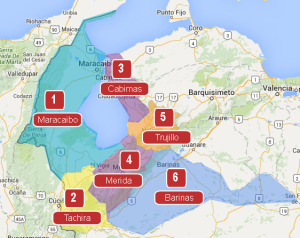
Raid Areas
This Mega Map Raid will be divided into 6 areas. Raid areas are shown on the map, with links to each area.