imported>PesachZ |
imported>PesachZ |
| Line 1: |
Line 1: |
| | <!--Do not change heading names without understanding the pages that may currently be linked to those sections.--> |
| | {{mbox|type=construction|text={{red|This page is currently being worked for a '''major revision''' in a separate user page.}} |
| | |
| | Click here to see the [[User:PesachZ/Glossary|revision in-progress]], and here to participate in the [http://www.waze.com/forum/viewtopic.php?f=276&t=125960 forum discussion about this revision].}} |
| {{SelectionBar}} | | {{SelectionBar}} |
| | The following terms are defined on this page to clarify the meaning of each of them as they relate to Waze. The are provided alphabetically for your convenience. |
| | {{Template:Compact_ToC}} |
|
| |
|
| {{Mbox|type=important|text=This page is updated from an external source.<br /> {{Red|'''Any changes made here may be overwritten.}}<br /> If you have suggested changes please contact one of the authors ({{username|GizmoGuy411}}, or {{username|PesachZ}}), or fill out [http://j.mp/GlossaryEntry this form].'''}} | | {{anchor|A}} |
| {{mbox|type=notice|text=This glossary page has been redesigned, and majorly overhauled on April 26th, 2015. Please see the [[Talk:Glossary|Talk page]] for details about the redesign, credits, forum links, and more.
| |
| }} | |
|
| |
|
| {{mbox|type=important|text=You must [https://wiki.waze.com/wiki/index.php?title=Special:UserLogin&returnto={{FULLPAGENAME}} login] above to ensure that you are viewing the latest revision of this page.
| | ====AGC - At Grade Connector==== |
| <small><small>You are seeing revisions only up toː {{#time: Y-m-d hːmːs e |{{REVISIONTIMESTAMP}}}}</small></small>
| | :Segments that interconnects roads at the same grade elevation. |
| }}
| | :See [[At-grade_connectors|At-grade connectors]] |
| | <!-- Added 2014-10-12 --> |
|
| |
|
| | ====AM - Area Manager==== |
| | :An assigned role to help manage a given geographical area. See [[Area_Manager|Area Manager]] |
| | <!-- Added 2012-10-11 --> |
|
| |
|
| This comprehensive Glossary has been designed to function as a glossary, an index and a cross reference by means of sorting features and a table of context index.<br /> | | ====AMGR - Waze AM Layers, AM Layers Editor for Country Managers==== |
| | :This third party web tool is used by Country Managers and Regional Coordinators to visualized managed areas for assignments. One of several tools from WME-TOOLS. |
| | :See [http://www.wme-tools.com/home/ WME-TOOLS] |
| | <!-- Added 2014-10-11 --> |
|
| |
|
| It attempts to include all of the many abbreviations, acronyms and terms that we may see in the various Waze communication mediums.<br />
| | ===={{anchor|angles}}Angle==== |
| | :There are three different types of angles: |
| | :* [[#Junction angle|Junction angle]] |
| | :* [[#Roundabout angle|Roundabout angle]] |
| | :* [[#Turn angle|Turn angle]] |
|
| |
|
| Some existed before Waze, while others were officially coined by Waze. Many evolved naturally within the various Waze communication mediums used by Wazers and staff alike. Regardless of origin, all are important to help understand Waze Speak!<br />
| | ====ASR - Automatic Speech Recognition==== |
| | :The ability of a smartphone to translate a user's voice commands into actions on the device |
|
| |
|
| Please carefully consider your use of the abbreviations and acronyms in your conversations, since
| | {{anchor|B}} |
| they can be unfamiliar when not used in conjunction with other terms or without defining context.<br />
| | ====BC - Best Continuation==== |
| | :The segment that Waze determines is what drivers would consider the "no turning path" or "going straight" through the intersection. This segment will get a 'continue' instruction, which is ignored by the client app. See [[Best continuation]] for more details. |
|
| |
|
| Many terms apply globally, however, this glossary is North American English centric.<br />
| | ===={{anchor|green}}BGS - Big Green Sign==== |
| | :A large green sign is the US standard road signage for exits and other information. |
|
| |
|
| The descriptions within this Glossary attempt to merely resolve ambiguity of terms, and reference other Wiki pages, articles, and sections, along with other Waze and external sources. This intentional lack of description content helps avoid duplication of source content, and facilitates future maintenance when source content changes.<br />
| | ====BM - Bookmarklet==== |
| | :A Javascript stored as a web browser bookmark. See [[Bookmarklets]] |
| | <!-- Added 2014-10-11 --> |
|
| |
|
| | {{anchor|C}} |
|
| |
|
| =====Usage hints===== | | ====Candies, bonus candies==== |
| | :Small candy shaped icons that appear on the Waze client app. Drive over them to collect the points associated. See [[Your_Rank_and_Points#Road_candies|Road candies]] for more information. |
|
| |
|
| * Sort on the date column to see the latest changes.
| | ====Carpool, carpool lane==== |
| * You can link directly to any item in the glossary table by putting the term name or any of its listed aliases, or abbreviations as a section link.
| | :A vehicle with 2 or more occupants. Also known as HOV Lanes and Transit Lanes, are lanes restricted for the use of cars carrying a specified number of occupants. See [[Carpool%2C_HOV%2C_Transit_lanes|Carpool lanes]] for more information. |
| **For example: you can link to the Wayfinder listing using [[{{FULLPAGENAME}}#WF]] or [[{{FULLPAGENAME}}#Wayfinder]]
| |
| ** If you link to a term or alias which is listed multiple times in the table, the link will go to the first one listed. To be certain the link goes to the correct entry make sure the term or alias you choose is not duplicated on any other entries. (E.g. a link to [[{{FULLPAGENAME}}#SM]] will go to the Self Management entry and not the State Manager entry)<br />
| |
| * When looking at any entry in this Glossary, you will see the main term followed by several other terms showing various relations to this term.
| |
| ** The second column lists any common aliases or abbreviations, telling you that all these terms have the same definition.
| |
| ** At the bottom of the description there may be links to other entries which help explain the current term. You will also find links to the relevant wiki pages and other sources here. Browsing these links is essential to understanding the current term properly.<br />
| |
| ** Listed underneath the link at the bottom of the description column are any other glossary entries which link to this entry as part of their description. These are entries which do not define the current term, rather the current term is used to help define them. These are listed in small text as <sub><sup>"Related Entries"</sup></sub>. Browsing these entries may give you a fuller understanding of the current topic.
| |
| {{Compact_ToC|center=yes|symnum=yes|name=Glossary Term Table of Contents<br><small><small>(Sort by "Glossary Term" before using this ToC)</small></small>}}
| |
|
| |
|
| ===Glossary Table=== | | ====CDP - Census Designated Place==== |
| <small>
| | :A United States Census Bureau term for a concentration of population that lack a separate municipal government, but otherwise resemble incorporated places. It is sometimes added to a city name with that classification if there are multiple cities in the same state with that name. |
| <!--######################################
| |
|
| |
|
| Please add entries in alphabetical ordered by the "Glossary Term"
| | ====Central reservation==== |
| | :Strip of land or barrier separating a dual carriageway. Also known as a median. |
|
| |
|
| New entries should be placed in alphabetical order sorted by the glossary term using the {{/Glossary item}} template, you can find instructions for use on the template page.
| | ====CM - Country Manager==== |
| | :An assigned role to help manage an entire country. |
| | :See [[Roles and responsibilities#Country_Manager|Country Manager]] |
| | <!-- Added 2014-12-07 --> |
|
| |
|
| ∆∆∆!!! CAUTION !!!∆∆∆
| | ====Cookie munching, cookies==== |
| Do not modify an existing entry's term or aliases without first checking for and correcting any other pages which may be linking to them.
| | :Cookies are the dots on unconfirmed roads (sometimes called pacman roads). Cookie munching (or road munching) is driving over such roads and earns [[Your_Rank_and_Points#How_are_points_calculated.3F|points]]. It also confirms the road is drive-able for the Waze server. See [[FAQ#What_are_those_dots_on_some_of_the_roads.3F|What are those dots...]] for more information. |
|
| |
|
| | {{anchor|D}} |
| | ====Dead-end node==== |
| | :[[Image:Segments Nodes Junctions.png|right|110px]]This is an [[#Endpoint node|endpoint node]] found at the end of a segment without another segment connected to its end, when the other endpoint node of the segment is connected to one or more other segments. |
| | {{Clear}} |
|
| |
|
| This following is the table configuration and header - Please do not edit
| | ====Directionality==== |
| | :Whether a road is one-way, two-way or Unknown. |
|
| |
|
| #######################################-->
| | ====Divided highway==== |
| {| class="wikitable sortable" border="1"
| | :See dual carriageway |
| !colspan="5"|<font size="5">Waze Glossary</font><br>(With sortable entries!)
| |
| |-
| |
| !Glossary Term!!Abbreviation<br />Acronym<br />Alias!!class="unsortable"|Description!!width="10"|Dates<br /><small>Updated (U)<br />Added (A)</small><!--
| |
| ----------------------------------------------------------------------------------------------
| |
|
| |
|
| The following is the first entry in the table.
| | ====Dogleg==== |
| See /Glossary_item template for adding entries.
| | :A dogleg is a shift in a road. Normally, when Road A meets Road B, both segments of Road A are at the same junction. In a dogleg, they don't match up. To cross road B on Road A, you must turn briefly onto Road B and turn back onto Road A short distance later. It is called a dogleg because it has the characteristic shape of a dog's leg. |
|
| |
|
| >>>>>When importing list replace everything between the two ---###---### lines
| | :See also micro-dogleg (mDL), a technique with a similar appearance to a dogleg, used for altering the angle Waze sees at a junction, which affects turn instructions. |
|
| |
|
| ---###---###---###---###---###---###---###---###---###---###---###---###---###---###---### -->
| | ====Dual carriageway==== |
| <!-- ##################################################################################### -->
| | :A road or highway in which the two directions of traffic are separated by a barrier, strip of land, or other obstruction (known as a central reservation or median). In Waze, such roads may be represented by parallel segments, one for each direction, but this should only be done under certain specific conditions. |
| {{anchor|!–9}}
| |
| <!-- ##################################################################################### -->
| |
| {{/Glossary_item|term=#WazeWin|WazeWin|anchor1=wazewin|anchor2=Waze Win|anchor3=waze win|anchor4=#wazewin|desc=A hashtag in various social media used to indicate posts related Waze saving Wazers time, and avoiding traffic. Usually attached to screenshots or descriptions of Waze routing users around heavy traffic using detours the driver would not have thought of on their own.<br><br>Also see the [http://en.wikipedia.org/wiki/Hashtag hashtag] Wikipedia|updated=2015-02-25|added=2015-02-23}}
| |
| <!-- ##################################################################################### -->
| |
| {{anchor|A}}
| |
| <!-- ##################################################################################### -->
| |
| {{/Glossary_item|term=AASHTO|(abbr.)|desc=See the [[#American Association of State Highway and Transportation Officials|American Association of State Highway and Transportation Officials]] Glossary Term|added=2015-04-09|noanchor=yes}}
| |
| {{/Glossary_item|term=Abbreviations|Acronyms|Big List|anchor1=The Big TTS Test List|desc=List of Abbreviations used in Waze.<br><br>See the [[Abbreviations and acronyms]] Wiki Page<br>Also see the [http://goo.gl/jmhW00 Text-to-Speech (TTS) Abbreviations in Waze Clients - Test List for North America "The Big List")] External page<br>Also see the [http://www.waze.com/forum/viewtopic.php?f=10&t=15178 Test of Text-to-Speech (TTS) Abbreviations in Waze Clients] Waze forum|added=2015-02-23}}
| |
| {{/Glossary_item|term=Acronyms|(alias)|desc=See the [[#Abbreviations|Abbreviations]] Glossary Term|added=2015-02-23|noanchor=yes}}
| |
| {{/Glossary_item|term=Advertisers Dashboard|anchor1=Waze Advertisers Dashboard|desc=See the [http://biz.waze.com biz.waze.com] Waze Site|added=2015-02-26}}
| |
| {{/Glossary_item|term=AGC|(abbr.)|desc=See the [[#At-Grade Connectors|At-Grade Connectors]] Glossary Term|added=2014-10-12|noanchor=yes}}
| |
| {{/Glossary_item|term=Alternative Intersections|desc=Many intersection and interchange styles exist with various names depending location. (Additional Waze links to be added later.)<br><br>See the [http://www.alternativeintersections.org/ Alternative Intersections] External page|related1=Loon|added=2015-04-01}}
| |
| {{/Glossary_item|term=American Association of State Highway and Transportation Officials|desc=American Association of State Highway and Transportation Officials<br><br>See the [http://www.transportation.org/ AASHTO] External page|added=2015-04-09}}
| |
| {{/Glossary_item|term=AMGR|(abbr.)|desc=See the [[#Waze AM Layers|Waze AM Layers]] Glossary Term|updated=2015-02-23|added=2014-08-11|noanchor=yes}}
| |
| {{/Glossary_item|term=Angle|anchor1=angles|desc=There are various types of angles used in Waze mapping.
| |
| Please choose the relevant Glossary Term:<br><br>See the [[#Junction angle|Junction angle]] Glossary Term<br>See the [[#Roundabout angle|Roundabout angle]] Glossary Term<br>See the [[#Turn angle|Turn angle]] Glossary Term<br>Also see the [[#Junction Angle Info|Juntion Angle Info]] Glossary Term|jump1=Junction angle|jump2=Roundabout angle|jump3=Turn angle|jump4=Junction Angle Info|added=2014-10-12}}
| |
| {{/Glossary_item|term=Area|desc=A "Place Area" is a Waze POI '''with''' an associated polygon displayed on the map, as opposed to the "Place Point".
| |
|
| |
|
| (Not the same as "Points" as used in Points Ranking)<br><br>See the [[#Places|Places]] Glossary Term<br>Also see the [[#Point|Point]] Glossary Term|related1=Point|jump1=Places|jump2=Point|added=2015-02-22}}
| | {{anchor|E}} |
| {{/Glossary_item|term=Area Manager|AM|anchor1=AM - Area Manager|desc=An assigned role to help manage and maintain the map of a given geographical area. | | ====Editable Area==== |
| <br><br>See the [[Area_Manager|Area Manager]] Wiki Page<br>Also see the [[#Editing Roles|Editing Roles]] Glossary Term|related1=Waze AM Layers|jump2=Editing Roles|updated=2015-02-08|added=2014-08-11}}
| | :A defined distance around the drives you have taken with Waze running within which you have rights to edit unlocked objects. See [[Waze_Map_Editor#Editable_Area|editable area]] for more information. |
| {{/Glossary_item|term=ASR|(abbr.)|desc=See the [[#Automatic Speech Recognition|Automatic Speech Recognition]] Glossary Term|added=2012-08-18|noanchor=yes}}
| |
| {{/Glossary_item|term=At-Grade Connectors|AGC|Connector|anchor1=At Grade Connector|anchor2=At Grade Connectors|anchor3=At-Grade Connector|anchor4=AGC - At Grade Connector|desc=Segments that interconnect roads at the same grade elevation.<br><br>See the [[At-grade connectors]] Wiki Page|added=2014-10-12}}
| |
| {{/Glossary_item|term=Automatic Speech Recognition|ASR|anchor1=ASR - Automatic Speech Recognition|desc=The ability of a smartdevice to convert voice commands into actions on the device.<br><br>See the [[#Voice Commands|Voice Commands]] Glossary Term|related1=Voice|jump1=Voice Commands|jump4=#Junction Angle Info|added=2012-08-18}}
| |
| {{/Glossary_item|term=Avatar|desc={{Minor Highway|''content for this entry is still in progress''}}|added=2015-02-23}}
| |
| <!-- ##################################################################################### -->
| |
| {{anchor|B}}
| |
| <!-- ##################################################################################### -->
| |
| {{/Glossary_item|term=Badges|desc={{Minor Highway|''content for this entry is still in progress''}}|added=2015-02-23}}
| |
| {{/Glossary_item|term=BBCode|desc=BBCode is a special implementation of HTML to enhance forum posts. In addition to the standard BBCodes as described in the guide linked below, Waze has added custom BBCodes, including: Table, Hide, and YouTube. The use of the Hide and YouTube codes are obvious when applied from the foum posting toolbar. The Table code however requires additional explanation.
| |
|
| |
|
| Table code tags:
| | ====Endpoint node==== |
| [table] starts a table with borders | | :[[Image:Segments Nodes Junctions.png|right|110px]]Also called an '''end node''' is found at both ends of a [[#Segment|segment]], is visible only after selecting a segment while in [[WME]], and when joined to other endpoint nodes create a [[#Junction|junction]]. |
| [tr] starts a row | | {{Clear}} |
| [td] open a cell | |
| [/td] closes a cell | |
| [/tr] closes a row
| |
| [/table] closes the table
| |
|
| |
|
| No other table tags or tag attributes are available. Nested tables are not permitted, and new lines are redered correctly within cells, as all other new lines within the table tags will merely appear above the table.<br><br>See the [http://www.waze.com/forum/faq.php?mode=bbcode Forum BBCode Guide] Waze forum|added=2015-02-25}}
| | ====Express lane==== |
| {{/Glossary_item|term=BC|(abbr.)|desc=See the [[#Best Continuation|Best Continuation]] Glossary Term|added=2014-09-14|noanchor=yes}}
| | :See [[Glossary#HOV.2C_HOV_Lane_-_High_Occupancy_Vehicle|HOV]] |
| {{/Glossary_item|term=BDP|(abbr.)|desc=See the [[#Big Detour Prevention|Big Detour Prevention]] Glossary Term|added=2015-01-30|noanchor=yes}}
| |
| {{/Glossary_item|term=Best Continuation|BC|anchor1=BC - Best Continuation|desc=The segment that Waze determines is what drivers would consider the "no turning path" or "going straight" through the intersection. This segment will get a 'continue' instruction, which is ignored by the client app.<br><br>See the [[Best continuation]] Wiki Page|added=2014-09-14}}
| |
| {{/Glossary_item|term=Best Map Editing Practice|Best Practices|desc=See the [[Best map editing practice]] Wiki Page|updated=2015-03-02|added=2015-01-30}}
| |
| {{/Glossary_item|term=Best Practices|(alias)|desc=See the [[#Best Map Editing Practice|Best Map Editing Practice]] Glossary Term|added=2015-03-02|noanchor=yes}}
| |
| {{/Glossary_item|term=Beta|desc=Typically the last software version before being released to the publc as a production version.<br><br>See the [[#Beta Testers|Beta Testers]] Glossary Term<br>Also see the [http://en.wikipedia.org/wiki/Beta#Computing Beta] Wikipedia|related1=Descartes|jump1=Beta Testers|added=2015-01-30}}
| |
| {{/Glossary_item|term=Beta Testers|desc=See the [[Roles and responsibilities#Beta_Testers|Roles and responsibilities]] Wiki Page|related1=Beta|related2=Center Code|added=2015-02-25}}
| |
| {{/Glossary_item|term=BGS|(abbr.)|desc=See the [[#Big Green Sign|Big Green Sign]] Glossary Term|added=2015-03-25|noanchor=yes}}
| |
| {{/Glossary_item|term=Big Detour Prevention|BDP|desc=A system designed to prevent routing off, and then back on to the same Freeway/Highway for a small savings in time.<br><br>See the [[Detour Prevention Mechanisms#Big Detours|Detour Prevention Mechanisms]] Wiki Page<br>Also see the [[#Small Detour Prevention|Small Detour Prevention]] Glossary Term|related1=Small Detour Prevention|jump2=Small Detour Prevention|added=2015-01-30}}
| |
| {{/Glossary_item|term=Big Green Sign|BGS|anchor1=green|anchor2=BGS - Big Green Sign|desc=A Big Green Sign is the US standard road signage for exits and other information.<br><br>Also see the [[#Manual on Uniform Traffic Control Devices|Manual on Uniform Traffic Control Devices]] Glossary Term|jump1=Manual on Uniform Traffic Control Devices|added=2012-08-18}}
| |
| {{/Glossary_item|term=Big List|(alias)|desc=See the [[#Abbreviations|Abbreviations]] Glossary Term|added=2015-02-23|noanchor=yes}}
| |
| {{/Glossary_item|term=Blog|desc=The Waze Blog<br><br>See the [http://blog.waze.com/ Waze Blog] Waze Blog|added=2015-01-30}}
| |
| {{/Glossary_item|term=BM|(abbr.)|desc=See the [[#Bookmarklets|Bookmarklets]] Glossary Term|added=2014-10-11|noanchor=yes}}
| |
| {{/Glossary_item|term=Bonus Candies|(alias)|desc=See the [[#Bonus points and road goodies|Bonus points and road goodies]] Glossary Term|added=2015-01-30|noanchor=yes}}
| |
| {{/Glossary_item|term=Bonus points and road goodies|Bonus Candies|Candies|Goodies|Road Goodies|anchor1=Candies, bonus candies|desc=Special items that appear on the Waze client app map to achive bonus points. Drive over them to collect the assciated points. These may be candy shaped, or other special shapes for various occaasions.<br><br>See the [[Your_Rank_and_Points#Road_candies|Road candies]] Wiki Page|added=2015-02-10}}
| |
| {{/Glossary_item|term=Bookmark|(alias)|desc=Place markers in your web browser store the link to websites. Scripts can be inserted instead of URLs to create Bookmarklets.|added=2015-01-30|noanchor=yes}}
| |
| {{/Glossary_item|term=Bookmarklets|BM|Bookmark|anchor1=BM - Bookmarklet|anchor2=Bookmarklet|desc=A Javascript stored as a web browser bookmark.<br><br>See the [[Bookmarklets]] Wiki Page|added=2014-10-11}}
| |
| {{/Glossary_item|term=BugZilla|desc=A third party "Defect Tracking System" or "Bug-Tracking System" '''previously used''' by Waze. Use of Bugzilla by Waze has been discontiued.<br><br>The [[Bugzilla|''archived'' previous usage of Bugzilla]] Wiki Page|added=2015-01-30}}
| |
| {{/Glossary_item|term=Bulb|(alias)|desc=See the [[#Loon|Loon]] Glossary Term|added=2015-04-01|noanchor=yes}}
| |
| {{/Glossary_item|term=Bulb-out|(alias)|desc=See the [[#Loon|Loon]] Glossary Term|added=2015-04-01|noanchor=yes}}
| |
| <!-- ##################################################################################### -->
| |
| {{anchor|C}}
| |
| <!-- ##################################################################################### -->
| |
| {{/Glossary_item|term=Camera Watch List|CWL|desc=Term used within the URO+ script extension.|added=2015-01-30}}
| |
| {{/Glossary_item|term=Candies|(alias)|desc=See the [[#Bonus points and road goodies|Bonus points and road goodies]] Glossary Term|added=2013-05-11|noanchor=yes}}
| |
| {{/Glossary_item|term=CAR|(abbr.)|desc=See the [[#Community Action Request|Community Action Request]] Glossary Term|added=2015-01-30|noanchor=yes}}
| |
| {{/Glossary_item|term=Car Pool Lane|Express Lane|HOV Lane|Transit Lane|anchor1=Carpool, carpool lane|anchor2=Express lane|anchor3=Transit lane|desc=A lane restricted to use exclusively by vehicles carrying the minimum number of paasengers to meet the local HOV regulation.<br><br>See the [[Carpool, HOV, Transit lanes]] Wiki Page|related1=High Occupancy Toll|related2=High Occupancy Vehicle|added=2013-03-12}}
| |
| {{/Glossary_item|term=Carriageway|desc=UK English term for Highway.<br><br>Also see the [[#Dual Carriageway|Dual Carriageway]] Glossary Term|jump1=Dual Carriageway|added=2015-01-30}}
| |
| {{/Glossary_item|term=Cartouche|desc=Name of Waze map editor system prior to the Waze Map Editor.<br><br>See the [[#Waze Map Editor|Waze Map Editor]] Glossary Term|related1=Descartes|jump1=Waze Map Editor|added=2015-01-30}}
| |
| {{/Glossary_item|term=CC|(abbr.)|desc=See the [[#Connected Citizens Program|Connected Citizens Program]] Glossary Term<br>See the [[#Center Code|Center Code]] Glossary Term|updated=2015-02-22|added=2015-01-30|noanchor=yes}}
| |
| {{/Glossary_item|term=CCP|(abbr.)|desc=See the [[#Connected Citizens Program|Connected Citizens Program]] Glossary Term|added=2015-02-22|noanchor=yes}}
| |
| {{/Glossary_item|term=CDP|(abbr.)|desc=See the [[#Census Designated Place|Census Designated Place]] Glossary Term|added=2013-09-10|noanchor=yes}}
| |
| {{/Glossary_item|term=Census Designated Place|CDP|anchor1=CDP - Census Designated Place|desc=A United States Census Bureau term for a concentration of population that lack a separate municipal government, but otherwise resemble incorporated places. It is sometimes added to a city name with that classification if there are multiple cities in the same state with that name.<br><br>See the [http://en.wikipedia.org/wiki/CDP CDP] Wikipedia|added=2013-09-10}}
| |
| {{/Glossary_item|term=Center Code|CC|desc=Third party Beta Test Management Solutions used by Waze<br><br>See the [http://waze.centercode.com/signup/ Waze CenterCode.com] External page<br>Also see the [[#Beta Testers|Beta Testers]] Glossary Term|jump2=Beta Testers|added=2015-01-30}}
| |
| {{/Glossary_item|term=Central Reservation|anchor1=Central reservation|desc=British English term for the strip of land or barrier separating a Dual Carriageway. ''Dual Carriageway is also a British term, for a Divided Highway''.<br><br>See the [[#Median|Median]] Glossary Term|jump1=Median|added=2010-10-11}}
| |
| {{/Glossary_item|term=CFI|(abbr.)|desc=See the [[#Continuous Flow Intersection|Continuous Flow Intersection]] Glossary Term|added=2015-01-30|noanchor=yes}}
| |
| {{/Glossary_item|term=CH|(abbr.)|desc=See the [[#WME Color Highlighter|WME Color Highlighter]] Glossary Term|added=2013-06-03|noanchor=yes}}
| |
| {{/Glossary_item|term=Champ|desc=See the [[#Community Roles|Community Roles]] Glossary Term|jump1=Community Roles|added=2015-01-30}}
| |
| {{/Glossary_item|term=Chat|(alias)|desc=See the [[#WME Chat|WME Chat]] Glossary Term<br>See the [[#Map Chat|Map Chat]] Glossary Term|updated=2015-02-26|added=2015-01-30|noanchor=yes}}
| |
| {{/Glossary_item|term=City Smudge|(alias)|desc=See the [[#Smudged City|Smudged City]] Glossary Term|added=2015-02-24|noanchor=yes}}
| |
| {{/Glossary_item|term=Client|desc={{Minor Highway|''content for this entry is still in progress''}}|added=2015-01-30}}
| |
| {{/Glossary_item|term=CM|(abbr.)|desc=See the [[#Country Manager|Country Manager]] Glossary Term<br>See the [[#Community Manager|Community Manager]] Glossary Term|updated=2015-02-20|added=2014-12-07|noanchor=yes}}
| |
| {{/Glossary_item|term=Codes|(alias)|desc=See the [[#Search Codes|Search Codes]] Glossary Term|added=2015-01-30|noanchor=yes}}
| |
| {{/Glossary_item|term=Community Action Request|CAR|desc={{Minor Highway|''content for this entry is still in progress''}}|added=2015-01-30}}
| |
| {{/Glossary_item|term=Community Forum|Forum|Waze Forum|desc={{Minor Highway|''content for this entry is still in progress''}}|added=2015-01-30}}
| |
| {{/Glossary_item|term=Community Manager|CM|desc=A Waze employee assigned as a liason between Waze staff and the leadership of a local editing community. Usually assigned to an entire country or region of countries.<br><br>See the [[#Community Roles|Community Roles]] Glossary Term|jump1=Community Roles|added=2015-01-30}}
| |
| {{/Glossary_item|term=Community Roles|desc=Roles, Champ, CM, GC, LC, RC, SM<br><br>See the [[Roles and responsibilities]] Wiki Page<br>Also see the [[#Roles|Roles]] Glossary Term|related1=Champ|related2=Community Manager|related3=Coordinator|related4=Country Coordinator|related5=Global Champ|related6=Local Champ|related7=Mentor|related8=Regional Coordinator|related9=State Manager|jump2=Roles|added=2015-01-30}}
| |
| {{/Glossary_item|term=Community Wiki|(alias)|desc=See the [[#Waze Wiki|Waze Wiki]] Glossary Term|added=2015-01-30|noanchor=yes}}
| |
| {{/Glossary_item|term=Connected Citizens|(alias)|desc=See the [[#Connected Citizens Program|Connected Citizens Program]] Glossary Term|added=2015-01-30|noanchor=yes}}
| |
| {{/Glossary_item|term=Connected Citizens NYC Meet-Up.|W10|desc=The W10 are the first 10 international cities, United States Departments of Transportation (DOTs), and municipal organizations whom Waze has empowered to serve their citizens in the Connected Citizens program.<br><br>See the [[#Connected Citizens Program|Connected Citizens Program]] Glossary Term<br>Also see the [http://www.prnewswire.com/news-releases/waze-launches-connected-citizens-program-debuts-inaugural-w10-277867931.html PR Newswire article] External page|jump1=Connected Citizens Program|added=2015-01-30}}
| |
| {{/Glossary_item|term=Connected Citizens Program|CC|CCP|Connected Citizens|desc=The Waze Connected Citizens Program
| |
| <br><br>See the [[Connected Citizens Program]] Wiki Page<br>Also see the [http://blog.waze.com/p/connected-citizens.html Connected Citizens] Waze Blog|related1=Connected Citizens NYC Meet-Up.|updated=2015-03-17|added=2015-01-30}}
| |
| {{/Glossary_item|term=Connectivity Score|desc=A number used to define how well the map of region is developed. Measured by Waze staff, the higher the percentage, the better. It rates how well roads are interconnected, when searcching for routes to and from various points in the region.|added=2015-02-24}}
| |
| {{/Glossary_item|term=Connector|(alias)|desc=See the [[#At-Grade Connectors|At-Grade Connectors]] Glossary Term|added=2015-01-30|noanchor=yes}}
| |
| {{/Glossary_item|term=Connector|desc={{Minor Highway|''content for this entry is still in progress''}}|added=2015-01-30}}
| |
| {{/Glossary_item|term=Continuous Flow Intersection|CFI|desc=A general category type of intersectiion<br><br>See the [[#Displaced Left Turn|Displaced Left Turn]] Glossary Term<br>Also see the [http://en.wikipedia.org/wiki/Continuous-flow_intersection Continuous Flow Intersection] Wikipedia|jump1=Displaced Left Turn|added=2015-01-30}}
| |
| {{/Glossary_item|term=Cookie Munching|Cookies|anchor1=Cookie munching, cookies|desc=Cookies are the dots on unconfirmed roads (sometimes called pacman roads). Cookie munching (or road munching) is driving over such roads, and earns points. It also confirms the road is drive-able for the Waze server.<br><br>See the [[Your_Rank_and_Points#How_are_points_calculated.3F|Points]] Wiki Page<br>See the [[FAQ#What_are_those_dots_on_some_of_the_roads.3F|What are those dots ... ? FAQ]] Wiki Page|related1=Road Munching|related2=Pacman Roads|related3=Munching|added=2010-10-11}}
| |
| {{/Glossary_item|term=Coordinator|desc=Coordinators are experts who coordinate between the local community and Waze Team, as community ambassadors. Usually Champs.<br><br>See the [[Roles_and_responsibilities#Coordinators|Coordinators]] Wiki Page<br>See the [[#Community Roles|Community Roles]] Glossary Term<br>Also see [[#Regional Coordinator|Regional Coordinator]] Glossary Term|related1=Country Coordinator|jump2=Community Roles|jump3=Regional Coordinator|added=2015-01-30}}
| |
| {{/Glossary_item|term=Country Coordinator|CC|desc=This is an uncommon term sometimes used to refer to Coordinators.<br><br>See the [[#Community Roles|Community Roles]] Glossary Term<br>See the [[#Coordinator|Coordinator]] Glossary Term|related1=Regional Coordinator|jump1=Community Roles|jump2=Coordinator|added=2015-01-30}}
| |
| {{/Glossary_item|term=Country Manager|CM|desc=An assigned role to help manage and maintain the map of an entire country.<br><br>See the [[Roles and responsibilities#Country_Manager|Country Manager]] Wiki Page<br>Also see the [[#Editing Roles|Editing Roles]] Glossary Term|jump2=Editing Roles|updated=2015-02-14|added=2014-12-07}}
| |
| {{/Glossary_item|term=Crowd Source|desc={{Minor Highway|''content for this entry is still in progress''}}|added=2015-01-30}}
| |
| {{/Glossary_item|term=Cul-de-sac|anchor1=culdesac|desc={{Minor Highway|''content for this entry is still in progress''}}|added=2015-01-30}}
| |
| {{/Glossary_item|term=Curve Point|(alias)|desc=As used in the Waze Map Editor Guide Full Clip Video. Term not commonly used otherwise.<br><br>See the [[#Geometry Node|Geometry Node]] Glossary Term<br>Also see the [http://www.youtube.com/watch?v=HVksbb1Z4SQ Waze Map Editor Guide Full Clip Video] External page|added=2015-01-30|noanchor=yes}}
| |
| {{/Glossary_item|term=Cut|anchor1=cut|anchor2=cutting|desc=To separate a single segment into two smallaer segments, by adding a junction node along the segment.<br><br>See the [[Map_Editing_Quick-start_Guide#Cutting_a_segment|Cut a segment]] Wiki Page|related1=Split|added=2015-03-22}}
| |
| {{/Glossary_item|term=CWL|(abbr.)|desc=See the [[#Camera Watch List|Camera Watch List]] Glossary Term|added=2015-01-30|noanchor=yes}}
| |
| <!-- ##################################################################################### -->
| |
| {{anchor|D}}
| |
| <!-- ##################################################################################### -->
| |
| {{/Glossary_item|term=DAB|(abbr.)|desc=See the [[#Disambigution|Disambigution]] Glossary Term|added=2015-01-30|noanchor=yes}}
| |
| {{/Glossary_item|term=Dashboard|desc=See the [[Dashboard]] Wiki Page|added=2015-01-30}}
| |
| {{/Glossary_item|term=Data Base|DB|desc={{Minor Highway|''content for this entry is still in progress''}}|added=2015-01-30}}
| |
| {{/Glossary_item|term=Data Waze|datawaze|anchor1=data-waze|desc=See the [http://data-waze.com/ Data Waze] Waze Blog|added=2015-02-24}}
| |
| {{/Glossary_item|term=datawaze|(alias)|desc={{Minor Highway|''content for this entry is still in progress''}}|added=2015-02-24|noanchor=yes}}
| |
| {{/Glossary_item|term=DB|(abbr.)|desc=See the [[#Data Base|Data Base]] Glossary Term|added=2015-01-30|noanchor=yes}}
| |
| {{/Glossary_item|term=DB|(abbr.)|desc=See the [[#Dashboard|Dashboard]] Glossary Term|added=2015-01-30|noanchor=yes}}
| |
| {{/Glossary_item|term=DB|(abbr.)|desc=See the [[#Dropbox|Dropbox]] Glossary Term|added=2015-02-23|noanchor=yes}}
| |
| {{/Glossary_item|term=Dead End Loops|desc={{Minor Highway|''content for this entry is still in progress''}}|added=2015-01-30}}
| |
| {{/Glossary_item|term=Dead End Node|anchor1=Dead-end node|desc=This is an Endpoint Node found at the end of a segment with no other segment connected to its end. When the other endpoint node of the segment is connected to one or more other segments.
| |
|
| |
|
| A Dead End Node should be visible at the end of a dead-end road, and should be corrected if not visible.<br><br>See the [[#End Point Node|End Point Node]] Glossary Term<br>Also see the [[#Node|Node]] Glossary Term<br>Also see the [[Creating_and_editing_road_segments#Fix_the_end-node_on_cul-de-sacs_and_dead-ends|Fixing Dead End Nodes]] Wiki Page|related1=Junction|jump1=End Point Node|jump2=Node|added=2012-08-18}}
| |
| {{/Glossary_item|term=Department of Transportation|DOT|desc={{Minor Highway|''content for this entry is still in progress''}}|added=2015-01-30}}
| |
| {{/Glossary_item|term=Descartes|desc=Working name for the previous Cartouche map editing system beta versions. (The term can still seen in the certain Waze URLs.)<br><br>See the [[#Cartouche|Cartouche]] Glossary Term<br>Also see the [[#Beta|Beta]] Glossary Term|jump1=Cartouche|jump2=Beta|added=2015-04-09}}
| |
| {{/Glossary_item|term=Destination|desc=Destination point for a driving route, with the origin being the starting point.
| |
| (This term may later be combined with "Ending Point".)<br><br>See the [[#Ending Point|Ending Point]] Glossary Term<br>Also see the [[#Origin|Origin]] Glossary Term|jump1=Ending Point|jump2=Origin|added=2015-04-01}}
| |
| {{/Glossary_item|term=Detour Prevention Mechanism|desc={{Minor Highway|''content for this entry is still in progress''}}|added=2015-01-30}}
| |
| {{/Glossary_item|term=Directionality|desc=Whether a segment is set to allow routing traffic across it in one-way, two-way or Unknown. For one-way you mus specify if it is in the direction strting from the "A" node to the "B" node, or vice versa.<br><br>See the [[Creating and editing road segments#Set_Road_Type.2C_Direction.2C_and_Elevation|Creating and editing road segments]] Wiki Page|added=2010-09-16}}
| |
| {{/Glossary_item|term=Dirt Road|DR|desc={{Road|style=background-color:tan;|Dirt Road}} is a road type in Waze, typically used to represent any dirt roads. The Road Types entry lists all the road types in order.<br>{{RoadType|Dirt Road / 4X4 Trail}}<br><br>See the [[#Road Types|Road Types]] Glossary Term|jump2=Road Types|updated=2015-02-15|added=2015-01-30}}
| |
| {{/Glossary_item|term=Disambigution|DAB|desc={{Minor Highway|''content for this entry is still in progress''}}|added=2015-01-30}}
| |
| {{/Glossary_item|term=Displaced Left Turn|DLT|desc=At specfic type of a Continuous Flow Intersection.<br><br>See the [[At-grade_connectors#Displaced_left_turn_.28DLT.29_intersection| Displaced Left Turn]] Wiki Page<br>The [Continuous Flow Intersection] Glossary Term links here<br>Also see the [http://en.wikipedia.org/wiki/Continuous-flow_intersection Continuous Flow Intersection] Wikipedia|related1=Continuous Flow Intersection|added=2015-01-30}}
| |
| {{/Glossary_item|term=Divide|Dividing|anchor1=divide|desc=The method to convert a single two-way segment, into two parallel one-way segments in opposite directions.<br><br>See the [[Best_map_editing_practice#When to divide a two-way road (and when not to)|Dividing a two-way road]] Wiki Page|related1=Divided Highway|related2=Split|added=2015-03-22}}
| |
| {{/Glossary_item|term=Divided Highway|Dual Carriageway|anchor1=Dual carriageway|anchor2=divided|desc=A road or highway in which the two directions of traffic are separated by a barrier, strip of land, or other obstruction (known as a median or central reservation). In Waze, such roads may be represented by parallel segments, one for each direction, but this should only be done under certain specific conditions. Dual Carriageway is a common term used for Divided Highway in UK English.<br><br>See the [[Junction_Style_Guide/Intersections#Divided road intersections|Divided road intersections]] Wiki Page<br>Also see the [[#Divide|Dividing a two-way road]] Glossary Term<br>Also see the [[#Un-Divide|Un-Dividing a divided highway]] Glossary Term<br>Also see the [[#Median|Median]] Glossary Term|related1=Split|jump2=Divide|jump3=Un-Divide|jump4=Median|updated=2015-03-22|added=2010-10-11}}
| |
| {{/Glossary_item|term=DLT|(abbr.)|desc=A specific type of Cotinous Flow Intersection.<br><br>See the [[#Displaced Left Turn|Displaced Left Turn]] Glossary Term|added=2015-01-30|noanchor=yes}}
| |
| {{/Glossary_item|term=Dogleg|anchor1=Dog Leg|desc=A dogleg is a shift in a road. Normally, when Road A meets Road B, both segments of Road A are at the same junction. In a dogleg, they don't match up. To cross road B on Road A, you must turn briefly onto Road B and turn back onto Road A short distance later. It is called a dogleg because it has the characteristic shape of a dog's leg.<br>
| |
| ''A micro-dogleg (mDL), is a technique with a similar appearance to a dogleg, used for altering the angle Waze sees at a junction, which affects turn instructions.''<br><br>Also see the [[#Micro-dogleg|Micro-dogleg]] Glossary Term|jump1=Micro-dogleg|added=2015-01-12}}
| |
| {{/Glossary_item|term=DOT|(abbr.)|desc=See the [[#Department of Transportation|Department of Transportation]] Glossary Term|added=2015-01-30|noanchor=yes}}
| |
| {{/Glossary_item|term=Down-Lock|anchor1=downlock|desc=Term used to descibe the process of adjusting the Segment Lock level in WME down to match the Rank of an editor to allow them to edit the segment(s).<br><br>See the [[#Segment Lock|Segment Lock]] Glossary Term<br>Also see the [[#Up-Lock|Up-Lock]] Glossary Term|related1=Up-Lock|jump1=Segment Lock|jump2=Up-Lock|added=2015-02-25}}
| |
| {{/Glossary_item|term=DR|(abbr.)|desc="Dr" is also used as an abbreviaion for "Drive" and "Dr." for "Doctor" in segment naming.<br><br>See the [[#Dirt Road|Dirt Road]] Glossary Term|added=2015-01-30|noanchor=yes}}
| |
| {{/Glossary_item|term=Drive|(alias)|desc=See the [[#Google Drive|Google Drive]] Glossary Term|added=2015-02-23|noanchor=yes}}
| |
| {{/Glossary_item|term=Driven Area|desc=Also see the [[#Editable Area|Editable Area]] Glossary Term|related1=Editable Area|jump2=Editable Area|added=2015-01-30}}
| |
| {{/Glossary_item|term=Drives|desc=See the [[#Road Types|Road Types]] Glossary Term|jump1=Road Types|added=2015-01-30}}
| |
| {{/Glossary_item|term=Drives Tab Enhancer|DTE|desc={{Minor Highway|''content for this entry is still in progress''}}|added=2015-01-30}}
| |
| {{/Glossary_item|term=Dropbox|DB|anchor1=Drop Box|desc={{Minor Highway|''content for this entry is still in progress''}}|added=2015-02-23}}
| |
| {{/Glossary_item|term=DTE|(abbr.)|desc=See the [[#Drives Tab Enhancer|Drives Tab Enhancer]] Glossary Term|added=2015-01-30|noanchor=yes}}
| |
| {{/Glossary_item|term=Dual Carriageway|(alias)|desc=The British English term for a Divided Highway.<br><br>See the [[#Divided Highway|Divided Highway]] Glossary Term|related1=Carriageway|added=2010-10-11|noanchor=yes}}
| |
| {{/Glossary_item|term=Duplicate Cities|desc={{Minor Highway|''content for this entry is still in progress''}}|added=2015-01-30}}
| |
| <!-- ##################################################################################### -->
| |
| {{anchor|E}}
| |
| <!-- ##################################################################################### -->
| |
| {{/Glossary_item|term=Editable Area|desc=The entire area within which you area able to edit items in the Waze Map Editor. This includes your driven, and managed areas.<br>
| |
| Also a WME Layer which highlights this area on the map. The WME "Editable Area" Layer does not however highlight the entire country if you are a Country Manager.<br><br>See the [[Waze_Map_Editor#Editable_Area|Editable Area]] Wiki Page<br>Also see the [[#Driven Area|Driven Area]] Glossary Term<br>Also see the [[#Managed Area|Managed Area]] Glossary Term|related1=Driven Area|jump2=Driven Area|jump3=Managed Area|updated=2015-04-16|added=2013-01-23}}
| |
| {{/Glossary_item|term=Editing Roles|desc=These are assigned roles given to users who request them, and show they are qualified. They exist to enable users to help manage and maintain the map.<br><br>See the [[Roles_and_responsibilities|Roles and responsibilities]] Wiki Page<br>Also see the [[#Roles|Roles and responsibilities]] Glossary Term|related1=Area Manager|related2=Country Manager|jump2=Roles|added=2015-02-15}}
| |
| {{/Glossary_item|term=Elevation|Level|desc=The vertical position of a road relative to other roads it crosses, starting from ground level.<br><br>See the [[Creating and editing road segments#Road elevation|Road elevation]] Wiki Page<br>Also see the [[Level (disambiguation)]] Wiki Page|related1=Grade|added=2015-01-30}}
| |
| {{/Glossary_item|term=End Point Node|anchor1=Endpoint node|desc=An End Point Node ''(AKA '''end node''')'' is found at both ends of a segment. Its' appearance is emphasized after selecting a segment while in WME. When joined to other endpoint nodes it creates a junction.<br><br>See the [[#Node|Node]] Glossary Term<br>Also see the [[#Junction|Junction]] Glossary Term|related1=Dead End Node|jump1=Node|jump2=Junction|added=2013-05-06}}
| |
| {{/Glossary_item|term=Ending Point|desc=Destination point for a driving route, with the origin being the starting point.
| |
| (This term may later be combined with "Destination".)|related1=Origin|related2=Destination|related3=Starting Point|added=2015-04-01}}
| |
| {{/Glossary_item|term=ERL|(abbr.)|desc=See the [[#Experimental Road Layer|Experimental Road Layer]] Glossary Term|added=2015-04-17|noanchor=yes}}
| |
| {{/Glossary_item|term=Estimated Time of Arrival|ETA|desc={{Minor Highway|''content for this entry is still in progress''}}|added=2015-01-30}}
| |
| {{/Glossary_item|term=ETA|(abbr.)|desc=See the [[#Estimated Time of Arrival|Estimated Time of Arrival]] Glossary Term|added=2015-01-30|noanchor=yes}}
| |
| {{/Glossary_item|term=Event|desc={{Minor Highway|''content for this entry is still in progress''}}|added=2015-01-30}}
| |
| {{/Glossary_item|term=Events|desc={{Minor Highway|''content for this entry is still in progress''}}|added=2015-04-01}}
| |
| {{/Glossary_item|term=Experimental Road Layer|ERL|desc=A new layer in the WME with updated graphic display of the roads. It is eventually planned to replace the existing road layer.<br><br>See the [ announcement] Waze forum|added=2015-04-17}}
| |
| {{/Glossary_item|term=Expert|(alias)|desc=See the [[#Waze Expert|Waze Expert]] Glossary Term|updated=2015-02-26|added=2015-01-30|noanchor=yes}}
| |
| {{/Glossary_item|term=Express Lane|(alias)|desc=See the [[#Car Pool Lane|Car Pool Lane]] Glossary Term|added=2012-08-18|noanchor=yes}}
| |
| {{/Glossary_item|term=Extension|desc=Usually refers to a browser extension script|added=2015-01-30}}
| |
| <!-- ##################################################################################### -->
| |
| {{anchor|F}} | | {{anchor|F}} |
| <!-- ##################################################################################### -->
| | ====Fw - Freeway==== |
| {{/Glossary_item|term=FAQ|(abbr.)|desc=See the [[#Frequently Asked Questions|Frequently Asked Questions]] Glossary Term|added=2015-01-30|noanchor=yes}}
| | :Motorway; the major road system in your country. {{RoadType|Freeway}} |
| {{/Glossary_item|term=FC|(abbr.)|desc={{Minor Highway|''content for this entry is still in progress''}}|added=2015-01-30|noanchor=yes}}
| |
| {{/Glossary_item|term=FE |(abbr.)|desc=See the [[#Ferry|Ferry]] Glossary Term|added=2015-01-30|noanchor=yes}}
| |
| {{/Glossary_item|term=Federal Highway Administration|FHWA|desc=The Federal Highway Administration is an agency within the U.S. Department of Transportation that supports State and local governments in the design, construction, and maintenance of the Nation’s highway system (Federal Aid Highway Program) and various federally and tribal owned lands (Federal Lands Highway Program).<br><br>See the [http://www.fhwa.dot.gov/ FHWA] External page<br>Also see the [http://en.wikipedia.org/wiki/Federal_Highway_Administration previous FHWA names] Wikipedia|related1=Manual on Uniform Traffic Control Devices|added=2015-01-30}}
| |
| {{/Glossary_item|term=Feed The Waze|desc={{Minor Highway|''content for this entry is still in progress''}}|added=2015-02-23}}
| |
| {{/Glossary_item|term=Ferry|FE|desc={{Private|Ferry}} is a road type in Waze used to represent ferry routes which can be taken with a vehicle.<br>{{RoadType|Ferry}}<br><br>See [[#Road Types|Road Types]] Glossary Term|jump3=Road Types|added=2015-01-30}}
| |
| {{/Glossary_item|term=FHWA|(abbr.)|desc=See the [[#Federal Highway Administration|Federal Highway Administration]] Glossary Term|added=2015-01-30|noanchor=yes}}
| |
| {{/Glossary_item|term=FM|(abbr.)|desc=See the [[#Formal Mentoring|Formal Mentoring]] Glossary Term|added=2015-01-30|noanchor=yes}}
| |
| {{/Glossary_item|term=Fork|anchor1=fork|desc=A point in a road where the road diverges to separate roads. This is common where a new Freeway diverges off an existing freeway, and also where a frontage road (aka service road) starts off of a main road.
| |
|
| |
|
| This is the MUTCD definition of "Split", and has been refered to as a "split in the road" in the past. However use of the word "split" has been ddepracated in the Waze vernacular.<br><br>See the [[Junction_Style_Guide/Interchanges#Freeway.2Fhighway_splits|Freeway forks]] Wiki Page<br>Also see the [[#MUTCD|MUTCD]] Glossary Term|related1=Split|jump2=MUTCD|added=2015-03-22}}
| |
| {{/Glossary_item|term=Formal Mentoring|FM|desc=The process of rapidly advancing editors skills and knowledge through an assigned mentor, in a formal arrangement with set expectations and time limits.<br><br>See the [[Mentoring/Formal|Formal Mentoring]] Wiki Page|related1=Mentor|related2=Mentoring|added=2015-01-30}}
| |
| {{/Glossary_item|term=Forms|desc=See the [[Forms]] Wiki Page|added=2015-01-30}}
| |
| {{/Glossary_item|term=Forum|(alias)|desc=See the [[#Community Forum|Community Forum]] Glossary Term|added=2015-01-30|noanchor=yes}}
| |
| {{/Glossary_item|term=Freeway|FW|Fwy|Motorway|anchor1=FWY|anchor2=Fw - Freeway|desc=Motorway; the major road system in your country.<br>{{Freeway}} is the highest of the road types in the Waze hierarchy. The Road Types entry lists all the road types in order.<br>{{RoadType|Freeway}}<br><br>See the [[#Road Types|Road Types]] Glossary Term|jump1=Road Types|added=2010-09-15}}
| |
| {{/Glossary_item|term=Frequently Asked Questions|FAQ|desc={{Minor Highway|''content for this entry is still in progress''}}|added=2015-01-30}}
| |
| {{/Glossary_item|term=Frontage Road|desc={{Minor Highway|''content for this entry is still in progress''}}|added=2015-02-23}}
| |
| {{/Glossary_item|term=Functional Classifiction|FC|desc={{Minor Highway|''content for this entry is still in progress''}}|added=2015-01-30}}
| |
| {{/Glossary_item|term=FW|(abbr.)|desc=See the [[#Freeway|Freeway]] Glossary Term|added=2010-09-15|noanchor=yes}}
| |
| {{/Glossary_item|term=Fwy|(abbr.)|desc=See the [[#Freeway|Freeway]] Glossary Term|added=2015-02-26|noanchor=yes}}
| |
| {{/Glossary_item|term=g|(abbr.)|desc=See the [[#Google Streetview|Google Streetview]] Glossary Term|added=2015-01-30|noanchor=yes}}
| |
| <!-- ##################################################################################### -->
| |
| {{anchor|G}} | | {{anchor|G}} |
| <!-- ##################################################################################### -->
| |
| {{/Glossary_item|term=GC|(abbr.)|desc=See the [[#Global Champ|Global Champ]] Glossary Term|added=2015-01-30|noanchor=yes}}
| |
| {{/Glossary_item|term=Geo-node|(alias)|desc=See the [[#Geometry Node|Geometry Node]] Glossary Term|added=2012-08-17|noanchor=yes}}
| |
| {{/Glossary_item|term=Geo-Ops|desc={{Minor Highway|''content for this entry is still in progress''}}|added=2015-02-21}}
| |
| {{/Glossary_item|term=Geographic Information System|GIS|desc=Commonly used by various governmental entities such as county auditors to provide parcel information along with maps.|added=2015-01-30}}
| |
| {{/Glossary_item|term=Geometry|desc=The layout or shape of a segment, or place area. Each road is made up of one or more segments. Segments, and Place Areas are made up of one or more straight line sections. These sections can be short, effectively allowing curves to be created in a segment. See Editing existing roads for more information.<br><br>See the [[Creating_and_editing_road_segments#Adjusting road geometry (nodes)|Adjusting road geometry (nodes)]] Wiki Page<br>See the [[Places#Area Place|Area Place]] Wiki Page|related1=Geometry Handle|added=2010-09-15}}
| |
| {{/Glossary_item|term=Geometry Handle|Handle|desc=Any object that can be used to adjust the geometry of a segment or node placement.<br><br>See the [[#Inter-geometry node|Inter-geometry node]] Glossary Term<br>Also see the [[#Geometry|Geometry]] Glossary Term|jump1=Inter-geometry node|jump2=Geometry|added=2015-01-30}}
| |
| {{/Glossary_item|term=Geometry Node|Geo-node|Geonode|Curve Point|anchor1=Geometry node|desc=[[Image:Segments Nodes Junctions.png|right|thumb|110px]][[Image:Segment_geometry_node.png|left|Segment geometry node]][[Image:Landmark_node.png|left|Landmark geometry node]]When editing a segment or Area Place, large white circles appear where the segment changes direction ultimately altering its shape. Click and drag them individually to alter the geometry of the segment or landmark. Press the {{key press|d}} key while the mouse is hovered over them to delete the geometry node. Alternately hold the {{key press|d}} key and then move the mouse over the nodes you want to delete.
| |
|
| |
|
| [[Image:Segment_intergeometry_node.png|left]][[Image:Landmark_intergeometry_node.png|left]]The smaller white circles between the geometry nodes are "inter"-geometry nodes. When you click and drag an inter-geometry node, it becomes a larger geometry node and two more inter-geometry nodes appear halfway between each side again.<br><br>See the [[#Node|Node]] Glossary Term<br>See the [[Creating and editing road segments#Editing existing roads|Editing existing roads]] Wiki Page|related1=Inter-geometry node|jump1=Node|added=2012-08-17}} | | ====Geometry==== |
| {{/Glossary_item|term=Geonode|(alias)|desc=See the [[#Geometry Node|Geometry Node]] Glossary Term|added=2012-08-17|noanchor=yes}} | | :The layout or shape of a [[#Segment|segment]]. Each road is made up of one or more segments. The segments are made up of one or more straight line sections. These sections can be short, effectively allowing curves to be created in a segment. See [[Creating and editing road segments#Editing existing roads|Editing existing roads]] for more information. |
| {{/Glossary_item|term=GHO|(abbr.)|desc=See the [[#Google Hangouts|Google Hangouts]] Glossary Term|updated=2015-02-26|added=2015-01-30|noanchor=yes}}
| | |
| {{/Glossary_item|term=GIS|(abbr.)|desc=See the [[#Geographic Information System|Geographic Information System]] Glossary Term|added=2015-01-30|noanchor=yes}}
| | ====Geometry node==== |
| {{/Glossary_item|term=Global Champ|GC|Waze Global Champ|anchor1=Global Champ (GC)|desc=An editor selected by Waze management to be part of the world community leadership of Waze. These are editors that show long standing contributions to the entire global Waze community.<br><br>See the [[Roles_and_responsibilities#Global_Champs|Global Champs]] Wiki Page<br>Also see the [[#Community Roles|Community Roles]] Glossary Term|jump2=Community Roles|updated=2015-03-04|added=2015-01-30}}
| | :[[Image:Segments Nodes Junctions.png|right|110px]][[Image:Segment_geometry_node.png|left|Segment geometry node]][[Image:Landmark_node.png|left|Landmark geometry node]]When editing a segment or Area Place, large white circles appear where the segment changes direction ultimately altering its shape. Click and drag them individually to alter the geometry of the segment or landmark. Press the '''d''' key while the mouse is hovered over them to delete the geometry node. Alternately hold the '''d''' key and then move the mouse over the nodes you want to delete. |
| {{/Glossary_item|term=Global Positioning System|GPS|anchor1=GPS - Global Positioning System|desc=The Global Positioning System is a satellite based system used by navigation devices to locate the device anywhere on the globe. Applications like Waze use this information to provide turn-by-turn information.<br><br>See the [[GPS (disambiguation)]] Wiki Page|added=2014-02-17}}
| | |
| {{/Glossary_item|term=GLR|(abbr.)|desc=See the [[#Great Lakes Region|Great Lakes Region]] Glossary Term|added=2015-03-25|noanchor=yes}}
| | :[[Image:Segment_intergeometry_node.png|left]][[Image:Landmark_intergeometry_node.png|left]]The smaller white circles between the geometry nodes are "inter"-geometry nodes. When you click and drag an inter-geometry node, it becomes a larger geometry node and two more inter-geometry nodes appear halfway between each side again. |
| {{/Glossary_item|term=GM|(abbr.)|desc=See the [[#Greasemonkey|Greasemonkey]] Glossary Term|added=2015-01-30|noanchor=yes}}
| | |
| {{/Glossary_item|term=GMAP|(abbr.)|desc=See the [[#Google Maps|Google Maps]] Glossary Term|added=2015-01-30|noanchor=yes}}
| | :See [[Creating and editing road segments#Editing existing roads|Editing existing roads]] for more information. |
| {{/Glossary_item|term=GMM|(abbr.)|desc=See the [[#Google Map Maker|Google Map Maker]] Glossary Term|added=2015-01-30|noanchor=yes}}
| | {{Clear}} |
| {{/Glossary_item|term=Goodies|(alias)|desc=See the [[#Bonus points and road goodies|Bonus points and road goodies]] Glossary Term|added=2015-01-30|noanchor=yes}}
| | |
| {{/Glossary_item|term=Google Drive|Drive|desc={{Minor Highway|''content for this entry is still in progress''}}|added=2015-02-23}}
| | ====Global Champ (GC)==== |
| {{/Glossary_item|term=Google Forms|desc={{Minor Highway|''content for this entry is still in progress''}}|added=2015-01-30}}
| | :A '''Global Champ''' is an editor selected by Waze management that shows long standing contributions to the entire global Waze community. Typically requires having been a Local Champ for some period of time. See: [[Your_Rank_and_Points#Forum_badges|Your_Rank_and_Points - Forum_badges]] <!-- Added 2015-03-04 --> |
| {{/Glossary_item|term=Google Hangouts|GHO|Hangout|HO|HoG|anchor1=Hangouts|desc={{Minor Highway|''content for this entry is still in progress''}}|added=2015-01-30}}
| | |
| {{/Glossary_item|term=Google Map Maker|GMM|desc={{Minor Highway|''content for this entry is still in progress''}}|added=2015-01-30}}
| | ====Gore==== |
| {{/Glossary_item|term=Google Maps|GMAP|desc={{Minor Highway|''content for this entry is still in progress''}}|added=2015-01-30}}
| | :A small triangular piece of land. The (typically) grassy area where the exit sign is placed. It also describes the area of land where the ramp merges with the highway. |
| {{/Glossary_item|term=Google Sheets|desc={{Minor Highway|''content for this entry is still in progress''}}|added=2015-01-30}}
| | <!-- Added 2014-11-02 --> |
| {{/Glossary_item|term=Google Streetview|SV|GSV|Street View|anchor1=StreetView|anchor2=Streetview|anchor3=SV - Street View|anchor4=Google StreetView|desc=Google Maps provides the ability to see local roads from the driver's perspective using the Map Editor Interface and Controls Street View icon below.<br><br>See the [[Map_Editor_Interface_and_Controls#StreetView|Streetview]] Wiki Page|related1=Waze Streetview|updated=2015-02-25|added=2015-01-30}}
| | |
| {{/Glossary_item|term=Gore|(alias)|desc=See the [[#Gore Point|Gore Point]] Glossary Term|added=2015-02-26|noanchor=yes}}
| | ====GPS - Global Positioning System==== |
| {{/Glossary_item|term=Gore Point|Gore|desc=A small triangular piece of land. The (typically) grassy area where the exit sign is placed. It also describes the area of land where the ramp merges with the highway.|updated=2015-02-26|added=2014-11-02}}
| | :The Global Positioning System is a satellite based system used by navigation devices to locate the device anywhere on the globe. Applications like Waze use this information to provide turn-by-turn information. |
| {{/Glossary_item|term=GPS|(abbr.)|desc=See the [[#Global Positioning System|Global Positioning System]] Glossary Term|added=2014-02-17|noanchor=yes}}
| | :See the [[GPS]] disambiguation page for links to the various related Waze topics. |
| {{/Glossary_item|term=Grade|desc=The elevation of a road with respect to surrounding roads. So a road would normally be at-grade - ground level.. A road going underneath in a tunnel would be below grade. A road going over would be above grade. At complicated junctions such as freeway interchanges there can be many grade levels.<br>
| | |
| In WME on a flat map we assign Elevations to show that while the roads cross, they do not connect because they are at different heights (or grades). Ground level = "Ground", below grade = a negative elevation, above grade = a positive elevation.<br><br>See the [[Creating and editing road segments#Road elevation|Road elevation]] Wiki Page<br>See the [[At-grade connectors]] Wiki Page<br>Also see the [[Junction Style Guide/Interchanges|Interchange Style Guide]] Wiki Page<br>Also see the [[#Elevation|Elevation]] Glossary Term|updated=2015-04-16|added=2010-09-15}}
| | ====Grade==== |
| {{/Glossary_item|term=Greasemonkey|GM|anchor1=Grease Monkey|desc=See the [[#Community Plugins, Extensions and Tools|Community Plugins, Extensions and Tools]] Glossary Term<br>Also see the [[#Tampermonkey|Tampermonkey]] Glossary Term|related1=Tampermonkey|jump1=Community Plugins, Extensions and Tools|jump2=Tampermonkey|added=2015-01-30}}
| | :The level or elevation of a road with respect to surrounding roads. So a road would normally be at level grade. A road going underneath in a tunnel would be a -1 grade. A road going over would be a +1 grade. At complicated junctions such as freeway interchanges there can be many levels. So on a flat map we assign levels to show that while the roads cross, they do not connect because they are at different heights or elevations. See [[At-grade connectors]] for more information. |
| {{/Glossary_item|term=Great Lakes Region|GLR|desc=One of the regions the USA is broken into. It includes the states of Illinois, Indiana, Michigan, Ohio, and Wisconsin.<br><br>See the [[USA/Great Lakes|Great Lakes]] Wiki Page|added=2015-03-25}}
| | |
| {{/Glossary_item|term=Groups|desc={{Minor Highway|''content for this entry is still in progress''}}|added=2015-01-30}}
| |
| <!-- ##################################################################################### -->
| |
| {{anchor|H}} | | {{anchor|H}} |
| <!-- ##################################################################################### -->
| | ====HOT, HOT Lane - High Occupancy Toll==== |
| {{/Glossary_item|term=Hall of Fame|HoF|desc=A scoreboard showing the editors with the most editing achievements in a project. These area posted after each MapRaid.<br><br>See the [[MapRaid#MapRaid Hall of Fame|MapRaid Hall of Fame]] Wiki Page|added=2015-04-17}}
| | |
| {{/Glossary_item|term=Handle|(alias)|desc=See the [[#Geometry Handle|Geometry Handle]] Glossary Term|added=2015-01-30|noanchor=yes}}
| | :A lane that permits single passenger vehicles who choose to pay a toll to take advantage of a lane that generally moves faster than the other lanes in the same direction. See [[Carpool%2C_HOV%2C_Transit_lanes|Carpool lanes]] for more information. |
| {{/Glossary_item|term=Hangouts|(alias)|desc=See the [[#Google Hangouts|Google Hangouts]] Glossary Term|updated=2015-02-26|added=2015-01-30|noanchor=yes}}
| | |
| {{/Glossary_item|term=Hazardous Materials|HM|desc=[[File:2015-04-09_15h48_54.png|100px]] MUTCD - Hazardous Materials sign examples.<br><br>See the [http://mutcd.fhwa.dot.gov/htm/2003r1/part2/fig2b-21_longdesc.htm MUTCD - Hazardous Materials] External page|added=2015-04-09}}
| | ====HOV, HOV Lane - High Occupancy Vehicle==== |
| {{/Glossary_item|term=HC|(abbr.)|desc=See the [[#Help Center|Help Center]] Glossary Term|added=2015-02-25|noanchor=yes}}
| | :A vehicle with 2 or more occupants. HOV Lanes, also known as Carpool Lanes and Transit Lanes, are lanes restricted for the use of cars carrying a specified number of occupants. See [[Carpool%2C_HOV%2C_Transit_lanes|Carpool lanes]] for more information. |
| {{/Glossary_item|term=Help|(alias)|desc=See the [[#Help Center|Help Center]] Glossary Term|updated=2015-02-26|added=2015-01-30|noanchor=yes}}
| | |
| {{/Glossary_item|term=Help Center|HC|Help|Support|desc=An interactive help site with FAQs, common support topics, tutorials, and the ability to submit support requests directly to Waze staff. This site is maintained by Waze staff.<br><br>See the [http://www.waze.com/support Support] Waze Help Center article|related1=nanoRep|updated=2015-02-25|added=2015-02-25}}
| |
| {{/Glossary_item|term=High Occupancy Toll|HOT|HOT Lane|anchor1=HOT, HOT Lane - High Occupancy Toll|desc=A lane that permits single passenger vehicles who choose to pay a toll to take advantage of an HOV lane that generally moves faster than the other lanes in the same direction.<br><br>See the [[#Car Pool Lane|Car Pool Lane]] Glossary Term|jump1=Car Pool Lane|updated=2015-02-27|added=2014-08-11}}
| |
| {{/Glossary_item|term=High Occupancy Vehicle|HOV|anchor1=HOV, HOV Lane - High Occupancy Vehicle|desc=A vehicle with a minimum number of passangers, at least two. Local regulations can specify HOV to mean at least two, three, or four passenger in the vehicle. Vehicles meeting these specifications may be entitled to special privileges.<br><br>See the [[#Car Pool Lane|Car Pool Lane]] Glossary Term|jump1=Car Pool Lane|added=2010-09-16}}
| |
| {{/Glossary_item|term=HM|(abbr.)|desc=See the [[#Hazardous Materials|Hazardous Materials]] Glossary Term|added=2015-04-09|noanchor=yes}}
| |
| {{/Glossary_item|term=HN|(abbr.)|desc=See the [[#House Numbers|House Numbers]] Glossary Term|added=2015-01-30|noanchor=yes}}
| |
| {{/Glossary_item|term=HO|(abbr.)|desc=Less dersireable abbreviation for Google Hangouts.<br><br>See the [[#Google Hangouts|Google Hangouts]] Glossary Term|updated=2015-02-26|added=2015-01-30|noanchor=yes}}
| |
| {{/Glossary_item|term=HoF|(abbr.)|desc=See the [[#Hall of Fame|Hall of Fame]] Glossary Term|added=2015-04-17|noanchor=yes}}
| |
| {{/Glossary_item|term=HoGs|(abbr.)|desc=Humorous abbreviaion occasionally used for "Hangout Groups".<br><br>See the [[#Google Hangouts|Google Hangouts]] Glossary Term|updated=2015-02-26|added=2015-01-30|noanchor=yes}}
| |
| {{/Glossary_item|term=HOT|(abbr.)|desc=See the [[#High Occupancy Toll|High Occupancy Toll]] Glossary Term|added=2014-08-11|noanchor=yes}}
| |
| {{/Glossary_item|term=HOT Lane|(alias)|desc=See the [[#High Occupancy Toll|High Occupancy Toll]] Glossary Term|added=2014-08-11|noanchor=yes}}
| |
| {{/Glossary_item|term=House Numbers|HN|desc={{Minor Highway|''content for this entry is still in progress''}}|added=2015-01-30}}
| |
| {{/Glossary_item|term=HOV|(abbr.)|desc=See the [[#High Occupancy Vehicle|High Occupancy Vehicle]] Glossary Term|added=2010-09-16|noanchor=yes}}
| |
| {{/Glossary_item|term=HOV Lane|(alias)|desc=See the [[#Car Pool Lane|Car Pool Lane]] Glossary Term|added=2014-08-11|noanchor=yes}}
| |
| <!-- ##################################################################################### -->
| |
| {{anchor|I}} | | {{anchor|I}} |
| <!-- ##################################################################################### -->
| | ====IGN==== |
| {{/Glossary_item|term=IGN|(abbr.)|desc=See the [[#IGN Editors|IGN Editors]] Glossary Term<br>Also see the [[#Inter-geometry node|Inter-geometry node]] Glossary Term|added=2013-03-11|noanchor=yes}}
| | :Editors paid by Waze to make updates to the map. Not to be confused with inter-geometry node. See [[IGN]] for more information. |
| {{/Glossary_item|term=IGN Editors|IGN|desc=Editors contracted by Waze to make updates to the map. (Not to be confused with inter-geometry node.)<br><br>See the [[IGN]] Wiki Page<br>Also see the [[#Inter-geometry node|Inter-geometry node]] Glossary Term|jump2=Inter-geometry node|added=2013-03-11}}
| |
| {{/Glossary_item|term=IL|(abbr.)|desc=See the [[#Israel Waze server|Israel Waze server]] Glossary Term<br>See the [[#Illinois USPS code|Illinois USPS code]] Glossary Term|added=2014-05-17|noanchor=yes}}
| |
| {{/Glossary_item|term=Illinois USPS code|desc=IL is the USPS postal code for the state of Illinois. It is easily confused with the Waze abbreviation for te Israel Waze Server.
| |
|
| |
|
| (This term is only included in glossary to compare with "IL" for Israel.)<br><br>Also see the [[#Israel Waze server|Israel Waze server]] Glossary Term|jump1=Israel Waze server|added=2015-02-21}}
| | ====IL==== |
| {{/Glossary_item|term=IM|(abbr.)|desc=See the [[#Informal Mentoring|Informal Mentoring]] Glossary Term|added=2015-01-30|noanchor=yes}}
| | :Israel. Standard two-letter ISO code, which also refers to the routing and editor infrastructures which is distinct from Rest Of World and North America. |
| {{/Glossary_item|term=Indentifer|ID:|anchor1=ID|anchor2=id|desc="ID:" is used within Permalinks to identify various objects within WME including, Cameras (unknown), Nodes (nodes=), Places (venues=), PURs (unknown), Segments (segments=), URs (mapUdateRequest=) Some ids are also visible in the left WME panel.|added=2015-02-25}}
| |
| {{/Glossary_item|term=Informal Mentoring|IM|desc=The process of helping editors advance their knowledge and skills as questions or issues arise, without any preexisting arrangement or expectations. This can be performed by anyone.|related1=Mentoring|added=2015-01-30}}
| |
| {{/Glossary_item|term=Inter-geometry node|desc=[[Image:Segment_intergeometry_node.png|left]][[Image:Landmark_intergeometry_node.png|left]]A "grab handle" that allows you to create a new geometry node. When you drag an inter-geometry node, it bends the segment at that point; when you release it, the inter-geometry node will become a new geometry node.
| |
|
| |
|
| Inter-geometry nodes appear on road segments and area places ''(previously landmarks)''. They will only appear when the segment/place is selected '''''and''''' the mouse is hovering over it. They appear midway between each existing pair of adjacent geometry nodes, allowing you to bend the shape midway between existing bends. In the case of segments, they also appear midway between the endpoints and the first existing geometry node, or, if there are no existing geometry nodes, midway in the segment.<br><br>See the [[#Geometry Node|Geometry Node]] Glossary Term<br>See the [[#Node|Node]] Glossary Term|related1=Geometry Handle|related2=IGN Editors|jump1=Geometry Node|jump2=Node|added=2014-07-29}}
| | :Illinois. Standard postal code for the state of Illinois in North America. |
| {{/Glossary_item|term=Interactive junction instruction algorithm|desc=A clickable interactive guide to determine what instruction, if any, will be given at the junction between any 2 segments.<br><br>See the [[Interactive junction instruction algorithm]] Wiki Page|added=2015-04-01}}
| |
| {{/Glossary_item|term=International |Intl|anchor1=Intl or INTL - International|desc=Commonly used in Waze to refer to the ROW server infrastructure and location.<br><br>See the [[#Rest Of World|Rest Of World]] Glossary Term<br>Also see the [[Banks of Servers]] Wiki Page|jump1=Rest Of World|added=2012-10-04}}
| |
| {{/Glossary_item|term=Internet Relay Chat|IRC|desc={{Minor Highway|''content for this entry is still in progress''}}|added=2015-01-30}}
| |
| {{/Glossary_item|term=IRC|(abbr.)|desc=See the [[#Internet Relay Chat|Internet Relay Chat]] Glossary Term|added=2015-01-30|noanchor=yes}}
| |
| {{/Glossary_item|term=Island|(alias)|desc=See the [[#Median|Median]] Glossary Term|added=2015-02-27|noanchor=yes}}
| |
| {{/Glossary_item|term=ISO-8601|ISO-8601|desc=See the [http://en.wikipedia.org/wiki/ISO_8601 ISO-8601] Wikipedia<br>Also see the [http://www.waze.com/forum/ucp.php?i=165 Time preference profile settings for forum] Waze forum<br>Also see the [[Special:Preferences#mw-prefsection-datetime|Time preference profile settings for Wiki]] Wiki Page|added=2015-01-30}}
| |
| {{/Glossary_item|term=Israel Waze server|IL|desc=One of the three separate sets of servers (infrastructure) containing Waze mapping and navigation systems. The three are Israel, North America (Canada and United States only), and the "Rest of the World," (ROW) or simply, "World."
| |
|
| |
|
| The Israel Server contains only the country of Israel, commonly reffered to as just "Israel" or the standard two-letter ISO code "IL".
| | ====Inter-geometry node==== |
| | :[[Image:Segment_intergeometry_node.png|left]][[Image:Landmark_intergeometry_node.png|left]]A "grab handle" that allows you to create a new [[#Geometry node|geometry node]]. When you drag an inter-geometry node, it bends the segment at that point; when you release it, the inter-geometry node will become a new geometry node. |
| | |
| | :Inter-geometry nodes appear on road [[#Segment|segments]] and [[#Area place|area places]] (previously landmarks). They will only appear when the segment/place is selected '''''and''''' the mouse is hovering over it. They appear midway between each existing pair of adjacent geometry nodes, allowing you to bend the shape midway between existing bends. In the case of segments, they also appear midway between the endpoints and the first existing geometry node, or, if there are no existing geometry nodes, midway in the segment. |
| | |
| | ====Intl or INTL - International==== |
| | :International abbreviation used to refer to the non-North America [[Servers|server]] infrastructure and location. See also [[#ROW|ROW]] |
|
| |
|
| All editing, driving, and reporting must take place on the correct server. This usually happens automatically, except for the editor, where switching to a specific destination may prompt you to change infrastructure.|related1=Illinois USPS code|added=2014-05-17}}
| |
| <!-- ##################################################################################### -->
| |
| {{anchor|J}} | | {{anchor|J}} |
| <!-- ##################################################################################### -->
| | |
| {{/Glossary_item|term=JAI|(abbr.)|desc=See the [[#Junction Angle Info|Junction Angle Info]] Glossary Term|added=2015-01-30|noanchor=yes}}
| | ==== {{Anchor|Junctions|Junction|Junction Point}}Junction ==== |
| {{/Glossary_item|term=JB|(abbr.)|desc=See the [[#Junction Box|Junction Box]] Glossary Term|added=2015-02-26|noanchor=yes}} | | :[[Image:Segments Nodes Junctions.png|right|120px|border]][[Image:Junction_normal.png|left|border]]The point where two or more road segments connect at their ends. It is sometimes called a 'junction node' or 'junction point', but should not be confused with other types of [[#Node|node]]. |
| {{/Glossary_item|term=JNF|(abbr.)|desc=See the [[#Junction Node Fixer|Junction Node Fixer]] Glossary Term|added=2015-03-18|noanchor=yes}}
| | |
| {{/Glossary_item|term=JSG|desc=See the [[#Junction Style Guide|Junction Style Guide]] Glossary Term|jump1=Junction Style Guide|added=2015-03-18}}
| | :Junctions look different depending on the situation:<br/> |
| {{/Glossary_item|term=Jturn|desc={{Minor Highway|''content for this entry is still in progress''}}|added=2015-02-23}}
| | :[[Image:Junction_selected.png|border|42px]] Selected and editable segment junction<br/> |
| {{/Glossary_item|term=Jughandle|desc=Also see the [http://en.wikipedia.org/wiki/Jughandle Jughandle] Wikipedia|added=2015-02-26}}
| | :[[Image:Junction_uneditable.png|border|42px]] Selected and uneditable segment junction (no permissions to change due to locks)<br/> |
| {{/Glossary_item|term=Junction|Junction Node|Junction Point|anchor1=Junctions|desc=[[Image:Segments Nodes Junctions.png|right|120px|border]][[Image:Junction_normal.png|left|border]]The point where two or more road segments connect at their ends. It is sometimes called a 'junction node' or 'junction point', but should not be confused with other types of nodes.<br><br>Junctions look different depending on the situation:<br/>[[Image:Junction_selected.png|border|42px]] Selected and editable segment junction<br/>[[Image:Junction_uneditable.png|border|42px]] Selected and uneditable segment junction (no permissions to change due to locks)<br/>[[Image:junction_unsaved.png|border|42px]] Changed, unsaved junction<br><br>A node should be visible at the end of a dead end road, and should be corrected if not visible.<br><br>See the [[Junction Style Guide]] Wiki Page<br>Also see the [[#Node|Nodes]] Glossary Term<br>Also see [[#Dead End Node|Dead End Node]] Glossary Term|related1=End Point Node|jump2=Node|jump3=Dead End Node|updated=2015-02-08|added=2010-09-16}}
| | :[[Image:junction_unsaved.png|border|42px]] Changed, unsaved junction |
| {{/Glossary_item|term=Junction angle|anchor1=Junction angles|desc=The measured angle between any two segments connected at a junction.<br><br>Also see the [[#Junction Angle Info|Junction Angle Info]] Glossary Term|related1=Angle|jump1=Junction Angle Info|updated=2015-02-08|added=2014-09-02}} | | :See [[Junction_Style_Guide|Junction Style Guide]] for more information. |
| {{/Glossary_item|term=Junction Angle|Angle|desc=The measured angle between any two segments connected at a junction.<br><br>See the [[Junction_Style_Guide/Controlling_turn_instructions|Junction Style Guide/Controlling turn instructions]] Wiki Page|related1=Angle|updated=2015-02-08 (U)|added=2014-09-02}}
| | |
| {{/Glossary_item|term=Junction Angle Info|JAI|desc=A browser extension script which displays Junction Angles or Turn Angles in WME. It can also estimate what a turn instruction will be for a given turn.<br><br>See the [[Community Plugins, Extensions and Tools#WME_Junction_Angle_info|WME Junction Angle Info]] Wiki Page|related1=Angle|related2=Junction angle|related3=Turn angle|updated=2015-02-08|added=2015-01-30}}
| | :A junction should be visible at the end of a dead end road, and [[Creating and editing road segments#Fix the end-node on cul-de-sacs and dead-ends|should be corrected]] if not visible.<br/>{{Clear}} |
| {{/Glossary_item|term=Junction Box|anchor1=Big Junctions|desc=Temporarily named Big Junctions in the following blog article that describes the concept.<br><br>See the [http://community-blog.waze.com/2014/12/big-junctions-are-coming-to-wme.html Big Junctions] Waze Blog|added=2015-02-26}}
| | |
| {{/Glossary_item|term=Junction Node|(alias)|desc=See the [[#Junction|Junction]] Glossary Term|added=2015-02-08|noanchor=yes}}
| | ===={{anchor|Junction angles}}Junction angle==== |
| {{/Glossary_item|term=Junction Node Fixer|JNF|desc={{Minor Highway|''content for this entry is still in progress''}}|added=2015-01-30}}
| | :The measured angle between any two segments connected at a junction. |
| {{/Glossary_item|term=Junction Point|(alias)|desc=See the [[#Junction|Junction]] Glossary Term|added=2015-02-08|noanchor=yes}}
| | :See [[#Angle|Angle]] for other similar terms. |
| {{/Glossary_item|term=Junction Style Guide|JSG|desc={{Minor Highway|''content for this entry is still in progress''}}|related1=JSG|added=2015-01-30}}
| | |
| <!-- ##################################################################################### -->
| |
| {{anchor|K}} | | {{anchor|K}} |
| <!-- ##################################################################################### -->
| |
| <!-- ##################################################################################### -->
| |
| {{anchor|L}} | | {{anchor|L}} |
| <!-- ##################################################################################### -->
| | |
| {{/Glossary_item|term=Landmark|(alias)|desc=The previously used term "Landmarks" has been deprecated in favor of the term "Places".<br><br>See the [[#Places|Places]] Glossary Term|added=2015-01-30|noanchor=yes}}
| | ====Level==== |
| {{/Glossary_item|term=LC|(abbr.)|desc=See the [[#Local Champ|Local Champ]] Glossary Term|added=2015-01-30|noanchor=yes}}
| | :May refer to road elevation or the WME [[Map_Editor_Interface_and_Controls#Zoom_Control|Zoom Control]]. See [[Level (disambiguation)|Level]] for other similar uses of the term. |
| {{/Glossary_item|term=Level|(alias)|desc=The disambiguation page lists other deprecated uses.<br><br>See the [[#Elevation|Elevation]] Glossary Term<br>Also see the [[Level (disambiguation)]] Wiki Page|added=2013-10-17|noanchor=yes}}
| | |
| {{/Glossary_item|term=Live Map|LM|anchor1=Livemap|desc={{Minor Highway|''content for this entry is still in progress''}}|added=2015-01-30}}
| | ====Local Champ (LC)==== |
| {{/Glossary_item|term=Live Map UR Overlay|LMUR|desc={{Minor Highway|''content for this entry is still in progress''}}|added=2015-01-30}}
| | :A '''Local Champ''' is an editor selected by Waze management that shows long standing contributions to the Waze community for their country. Typically Local Champs have been a Country Manager for some period of time. See: [[Your_Rank_and_Points#Forum_badges|Your_Rank_and_Points - Forum_badges]] <!-- Added 2015-03-04 --> |
| {{/Glossary_item|term=LM|(abbr.)|desc=See the [[#Live Map|Live Map]] Glossary Term|added=2015-01-30|noanchor=yes}}
| | |
| {{/Glossary_item|term=Local Champ|LC|Waze Local Champ|anchor1=Local Champ (LC)|desc=An editor selected by Waze management or the local community leadership to join the local community leadership of a specific country. These are editors that show long standing contributions to the Waze community for their country.<br><br>See the [[Roles_and_responsibilities#Local_Champs|Local Champs]] Wiki Page<br>Also see the [[#Community Roles|Community Roles]] Glossary Term|jump2=Community Roles|updated=2015-03-04|added=2015-01-30}}
| |
| {{/Glossary_item|term=Lock|desc=See the [[#Segment Lock|Segment Lock]] Glossary Term|jump1=Segment Lock|added=2015-01-30}}
| |
| {{/Glossary_item|term=Loon|Bulb|Bulb-out|desc=A widened section of road to accomodate a U-Turn type of intersection, as used in many types of Alternative Intersection types including Michigan Left Turns, a type of Median U-Turn Intersection.
| |
| (Links are pending additional entry edits)<br><br>Also see the [[#Alternative Intersections|Alternative Intersections]] Glossary Term|jump1=Alternative Intersections|added=2015-04-01}}
| |
| {{/Glossary_item|term=Loops|desc={{Minor Highway|''content for this entry is still in progress''}}|added=2015-01-30}}
| |
| <!-- ##################################################################################### -->
| |
| {{anchor|M}} | | {{anchor|M}} |
| <!-- ##################################################################################### -->
| | ====Map issue==== |
| {{/Glossary_item|term=Major Events|(alias)|desc=See the [[#Major Traffic Events|Major Traffic Events]] Glossary Term|added=2015-03-16|noanchor=yes}}
| | :A button on the Waze client app to indicate there is a problem with the map. See [[#Update_Request_.28UR.29|Update Requests]] for more information. |
| {{/Glossary_item|term=Major Highway|MH|anchor1=MH - Major Highway|desc={{Major Highway}} is one of three highway types used in Waze. The Road Types entry lists all the road types in order.<br>{{RoadType|Major Highway}}<br>Note that when abbreviated to MH, the "M" must be capitalized to differentiate from "mH - Minor Highway".<br><br>See the [[#Road Types|Road Types]] Glossary Term|jump1=Road Types|added=2014-08-11}} | | |
| {{/Glossary_item|term=Major Traffic Events|MTE|Major Events|anchor1=Mega Events|desc=See the [[Real time closures#Major traffic events|Major Traffic Events]] Wiki Page|added=2015-03-16}}
| | ====Micro-dogleg==== |
| {{/Glossary_item|term=Managed Area|desc={{Minor Highway|''content for this entry is still in progress''}}|related1=Editable Area|added=2015-01-30}}
| | :{{anchor|micro-doglef|mDL}}A micro-dogleg, abbreviated mDL, is a one or two geometry nodes at the end of a segment, which change the true angle at which the segment meets its junction, without changing the appearance of the junction. The geometry nodes are very short, and nearly or completely invisible at the zoom levels available on the client (app). An mDL is frequently used to force Turn instructions instead of Keep/Exit instructions and vice-versa. They have a shape similar to a [[#Dogleg|dogleg junction]]. |
| {{/Glossary_item|term=Manual on Uniform Traffic Control Devices|MUTCD|desc=National source of road, sign, and abbreviation guidelines, published by the Federal Highway Administration
| | |
| | :For example, if the angle at which a local road meets a highway is 20 degrees, Waze will instruct a user turning off the highway to "EXIT RIGHT" (assuming right hand drive countries). If we consider this a turnoff (at grade junction), and not an 'exit,' we will want to force Waze to treat it as a turn. By making a tiny crook (the micro-dogleg) within less than 2.5 meters of the local segment, we can have the final piece of the segment meet the highway at 90 degrees, and cause a turn instruction. For more details, see the [[Junction Style Guide]] and the [[PROMPTS|technical paper on Waze instructions]]. |
| | |
| | ====MP - Map Problem==== |
| | :An automated report from the Waze servers that identifies a possible problem with the map. See [[Map problem]] for more information. |
| | |
| | ====Map tile, tile==== |
| | :The Waze map is divided into a grid using 1km-square areas which are called tiles or map tiles. Changes to the map are processed on a per-tile basis. Changes to any part of a map tile causes Waze to mark the tile as changed and it will be rebuilt in the next map update cycle. |
| | |
| | ====MapRaid==== |
| | :A collaborative effort by many editors to fix the map and resolve the majority of reports in an area. Details at the [[MapRaid]] entry. |
| | |
| | ====Median, median barrier==== |
| | :Strip of land or barrier separating a divided highway or motorway. Also known as a central reservation. See [[#Dual carriageway|Dual carriageway]]. |
|
| |
|
| Individual states often have their own guidelines expaned from the MUTCD.<br><br>See the [http://mutcd.fhwa.dot.gov MUTCD] External page<br>Also see the [[#Federal Highway Administration|FHWA]] Glossary Term|related1=Big Green Sign|jump2=Federal Highway Administration|added=2015-01-30}}
| | ====MH - Major Highway==== |
| {{/Glossary_item|term=Map Chat|Chat|desc={{Minor Highway|''content for this entry is still in progress''}}|added=2015-02-23}} | | :One of many road types. {{RoadType|Major Highway}} Note that when abbreviated to MH, the "M" must be capitalized to differentiate from "mH - Minor Highway." |
| {{/Glossary_item|term=Map Issue|anchor1=Map issue|anchor2=MI|desc=A button on the Waze client app Report menu to indicate there is a problem with the map by means of an Update Request.
| |
|
| |
|
| | ====mH - Minor Highway==== |
| | :One of many road types. {{RoadType|Minor Highway}} Note that when abbreviated to mH, the "m" must '''''not''''' be capitalized, to differentiate from "MH - Major Highway." |
|
| |
|
| <br><br>See the [http://support.google.com/waze/answer/6080884 Create a report] Waze Help Center article|related1=Update Request|added=2013-02-25}}
| | ====Motorway==== |
| {{/Glossary_item|term=Map Problem|MP|anchor1=MP - Map Problem|desc=An automated report from the Waze servers that identifies a possible problem with the map. See [[Map problem]] for more information.<br><br>See the [[Map_Problems_in_Waze_Map_Editor|Map Problem]] Wiki Page|added=2014-08-11}}
| | :[[#Freeway|Freeway]]; the major road system in your country. |
| {{/Glossary_item|term=Map Protection|desc=Methods to protect and uphold the quality of the Waze map from both intentional and unintentional harm.<br><br>See the [[Map Protection]] Wiki Page|related1=Throttling|related2=Regression Checker|added=2015-02-09}}
| | |
| {{/Glossary_item|term=Map Team|desc={{Minor Highway|''content for this entry is still in progress''}}|added=2015-02-21}}
| | ====Munching==== |
| {{/Glossary_item|term=Map Tile|Tile|anchor1=Map tile, tile|desc=The Waze map is divided into a grid using 1km-square areas which are called tiles or map tiles. Changes to the map are processed on a per-tile basis. Changes to any part of a map tile causes Waze to mark the tile as changed and it will be rebuilt in the next map update cycle.<br><br>See the [[Map tiles]] Wiki Page|added=2012-02-08}}
| | :Driving over roads which have not previously been driven (pacman roads). See [[#Cookie_munching.2C_cookies|cookie munching]] for more information. |
| {{/Glossary_item|term=Map-A-Thon|anchor1=Mapathon|anchor2=MapAThon|anchor3=Map-a-Thon|anchor4=Map-a-thon|desc=See the [] Waze Blog|added=2015-02-24}}
| |
| {{/Glossary_item|term=MapRaid|MR|Raid|anchor1=Map Raid|anchor2=Mapraid|desc=A collaborative effort by many editors update the mapin a defined area. A MapRaid may focus on different aspects of the map.<br><br>See the [[MapRaid]] Wiki Page|related1=Raid Leader|added=2014-11-10}}
| |
| {{/Glossary_item|term=mDL|(abbr.)|desc=See the [[#Micro-dogleg|Micro-dogleg]] Glossary Term|added=2015-04-15|noanchor=yes}}
| |
| {{/Glossary_item|term=Median|Median Barrier|Median Divider Island|Median Strip|Island|anchor1=Median, median barrier|desc=Strip of land or barrier separating a Divided Highway. This is known as a Central Reservation in British English.<br><br>See the [http://en.wikipedia.org/wiki/Median_strip Median strip] Wikipedia|related1=Central Reservation|related2=Divided Highway|updated=2015-02-27|added=2010-10-11}}
| |
| {{/Glossary_item|term=Median Barrier|(alias)|desc=See the [[#Median|Median]] Glossary Term|added=2010-10-11|noanchor=yes}}
| |
| {{/Glossary_item|term=Median Divider Island|(alias)|desc=See the [[#Median|Median]] Glossary Term|added=2015-02-27|noanchor=yes}}
| |
| {{/Glossary_item|term=Median Strip|(alias)|desc=See the [[#Median|Median]] Glossary Term|added=2015-02-27|noanchor=yes}}
| |
| {{/Glossary_item|term=Median U-Turn Intersection|MUTI|desc={{Minor Highway|''content for this entry is still in progress''}}|related1=Michigan Left Turn|added=2015-01-30}}
| |
| {{/Glossary_item|term=MediaWiki|desc={{Minor Highway|''content for this entry is still in progress''}}|added=2015-01-30}}
| |
| {{/Glossary_item|term=Mega MapRiad|MMR|desc={{Minor Highway|''content for this entry is still in progress''}}|added=2015-04-01}}
| |
| {{/Glossary_item|term=Mentor|desc=An experienced and knowledgeable editor, assigned the role to teach others, and help them become better editors.<br><br>See the [[Mentoring/Formal#Become_a_Mentor_or_Mentee|Becoming a Mentor]] Wiki Page<br>See the [[#Formal Mentoring|Formal Mentoring]] Glossary Term<br>See the [[#Community Roles|Community Roles]] Glossary Term|jump2=Formal Mentoring|jump3=Community Roles|added=2015-02-20}}
| |
| {{/Glossary_item|term=Mentoring|desc=Experienced editors passing on their knowledge and skills to others. There are different categories of mentoring.<br><br>See the [[Mentoring]] Wiki Page<br>Also see the [[#Formal Mentoring|Formal Mentoring]] Glossary Term<br>Also see the [[#Informal Mentoring|Informal Mentoring]] Glossary Term|jump2=Formal Mentoring|jump3=Informal Mentoring|added=2015-01-30}}
| |
| {{/Glossary_item|term=MH|(abbr.)|desc=See the [[#Major Highway|Major Highway]] Glossary Term|added=2014-08-11|noanchor=yes}}
| |
| {{/Glossary_item|term=mH|(abbr.)|desc=See the [[#Minor Highway|Minor Highway]] Glossary Term|added=2014-08-11|noanchor=yes}}
| |
| {{/Glossary_item|term=Michigan Left Turn|MLT|anchor1=Michigan Left|desc=A type of Median U-Turn Intersection commonly used in Michigan and adopted by other states.
| |
| <br><br>See the [[User:Davielde/Michigan_left|Michigan Left]] Wiki Page<br>Also see the [[#Median U-Turn Intersection|Median U-Turn Intersection]] Glossary Term|jump2=Median U-Turn Intersection|added=2015-04-01}}
| |
| {{/Glossary_item|term=Micro-dogleg|mDL|μDL|anchor1=micro-dogleg|anchor2=micro dogleg|anchor3=Micro Dogleg|anchor4=Micro-Dogleg|desc=A one or two geometry nodes at the end of a segment, which change the true angle at which the segment meets its junction, without changing the appearance of the junction. The geometry nodes are very close to the junction, and nearly or completely invisible at the zoom levels available on the client (app). An mDL is frequently used to force "Turn" instructions instead of "Keep/Exit" instructions and vice-versa. They have a shape similar to a dogleg junction.
| |
|
| |
|
| For example, if the angle at which a local road meets a highway is 20 degrees, Waze will instruct a user turning off the highway to "EXIT RIGHT" (assuming right hand drive countries). If we consider this a 'turnoff' ''(at grade junction)'', and not an 'exit', we will want to force Waze to treat it as a 'turn'. By making a tiny crook (the micro-dogleg) at the very start of the local segment, we can have the final piece of the segment meet the highway at 90 degrees, and cause a turn instruction.<br><br>See the [[Junction Style Guide]] Wiki Page<br>See the [[#How Waze determines turn / keep / exit maneuvers|How Waze determines turn / keep / exit maneuvers]] Glossary Term|related1=Dogleg|jump2=How Waze determines turn / keep / exit maneuvers|updated=2015-04-15|added=2015-01-12}}
| |
| {{/Glossary_item|term=Minimum Bounding Box|desc=The AMGR tool used by Regional Coordinators reduces irregular multipoint polygons as used for Area Managers, and State Managers to a four point rectangle aligned along longitude and latitude lines using a minimum bounding box formula.|added=2015-01-30}}
| |
| {{/Glossary_item|term=Minor Highway|mH|anchor1=mH - Minor Highway|desc={{Minor Highway}} is one of three highway types used in Waze. The Road Types entry lists all the road types in order.<br>{{RoadType|Minor Highway}}<br>Note that when abbreviated to mH, the "m" must '''not''' be capitalized to differentiate from "MH - Major Highway".<br><br>See the [[#Road Types|Road Types]] Glossary Term|jump1=Road Types|added=2014-08-11}}
| |
| {{/Glossary_item|term=MLT|(abbr.)|desc=See the [[#Michigan Left Turn|Michigan Left Turn]] Glossary Term|added=2015-01-01|noanchor=yes}}
| |
| {{/Glossary_item|term=MMR|(abbr.)|desc=See the [[#Meg MapRaid|Meg MapRaid]] Glossary Term|added=2015-04-01|noanchor=yes}}
| |
| {{/Glossary_item|term=Moods|desc={{Minor Highway|''content for this entry is still in progress''}}|added=2015-01-30}}
| |
| {{/Glossary_item|term=Motorway|(alias)|desc=See the [[#Freeway|Freeway]] Glossary Term|added=2010-09-15|noanchor=yes}}
| |
| {{/Glossary_item|term=MP|(abbr.)|desc=See the [[#Map Problem|Map Problem]] Glossary Term|added=2014-08-11|noanchor=yes}}
| |
| {{/Glossary_item|term=MR|(abbr.)|desc=See the [[#MapRaid|MapRaid]] Glossary Term|added=2015-02-21|noanchor=yes}}
| |
| {{/Glossary_item|term=MTE|(abbr.)|desc=See the [[#Major Traffic Events|Major Traffic Events]] Glossary Term|added=2015-03-16|noanchor=yes}}
| |
| {{/Glossary_item|term=Multiuse Lanes|desc={{Minor Highway|''content for this entry is still in progress''}}|added=2015-01-30}}
| |
| {{/Glossary_item|term=Munching|desc=See the [[#Cookie Munching|Cookie Munching]] Glossary Term|jump1=Cookie Munching|added=2010-10-11}}
| |
| {{/Glossary_item|term=MUTCD|(abbr.)|desc=See the [[#Manual on Uniform Traffic Control Devices|Manual on Uniform Traffic Control Devices]] Glossary Term|related1=Fork|added=2015-01-30|noanchor=yes}}
| |
| {{/Glossary_item|term=MUTI|(abbr.)|desc=See the [[#Median U-Turn Intersection|Median U-Turn Intersection]] Glossary Term|added=2015-01-30|noanchor=yes}}
| |
| {{/Glossary_item|term=My Car|desc={{Minor Highway|''content for this entry is still in progress''}}|added=2015-02-23}}
| |
| {{/Glossary_item|term=My Waze|anchor1=MyWaze|desc={{Minor Highway|''content for this entry is still in progress''}}|added=2015-02-23}}
| |
| <!-- ##################################################################################### -->
| |
| {{anchor|N}} | | {{anchor|N}} |
| <!-- ##################################################################################### -->
| | ====NA - North America==== |
| {{/Glossary_item|term=NA|(abbr.)|desc=See the [North American] Glossary Term links here|added=2012-10-04|noanchor=yes}}
| | :Abbreviation used for the [[servers]] that cover the USA and Canada maps. It does not include Mexico. |
| {{/Glossary_item|term=Name Normalization|NN|NormName|anchor1=NameNorm|desc=The process of inspecting all the segment names in an area, correcting common errors, and ensuring they conform to local naming standards. |added=2015-01-30}}
| |
| {{/Glossary_item|term=nanoRep|desc={{As of|2014|11|18}}, Waze has retired the use of nanoRep in favor of a Google product - the Google Help Center.
| |
|
| |
|
| nanoRep was an automated support system managed by Waze directly. It provided information and basic troubleshooting information on Waze. It was accesible from the web and the Waze client app, with a characteristic "Ask a question..." box. The page has since been removed from the Waze site.<br><br>See the [[#Help Center|Help Center]] Glossary Term|jump1=Help Center|updated=2015-04-19|added=2013-06-01}}
| | ====nanoRep==== |
| {{/Glossary_item|term=National Functional Class|NFC|desc={{Minor Highway|''content for this entry is still in progress''}}|added=2015-01-30}}
| | :As of 2014-11-18, Waze has retired the use of Nanorep favor of a Google product. This section will need to be revised accordingly. |
| {{/Glossary_item|term=Navigation Guidance|desc={{Minor Highway|''content for this entry is still in progress''}}|added=2015-02-23}}
| |
| {{/Glossary_item|term=NFC|(abbr.)|desc=See the [[#National Functional Class|National Functional Class]] Glossary Term|added=2015-01-30|noanchor=yes}}
| |
| {{/Glossary_item|term=NI |(abbr.)|desc=See the [[#Not Identified|Not Identified]] Glossary Term|added=2015-01-30|noanchor=yes}}
| |
| {{/Glossary_item|term=No-Name Segment|anchor1=No Name Segment|desc=A segment with no name (the "none" check-box for street name is checked) <br><br>See the [[Interactive junction instruction algorithm]] Wiki Page<br>See the [[User:PesachZ/Road name inheritance|Road name inheritance]] Wiki Page|added=2015-04-01}}
| |
| {{/Glossary_item|term=Node|anchor1=Nodes|desc=There are five different types of nodes:
| |
|
| |
|
| [[Image:Segments Nodes Junctions.png|Center|300px]]|related1=Junction|related2=Dead End Node|related3=End Point Node|related4=Geometry Node|related5=Inter-geometry node|added=2010-09-16}}
| | :The automated support system managed by Waze directly. It provides information and basic troubleshooting information on Waze. It may have newer information not yet updated in the Wiki. See the [http://www.waze.com/support/question nanoRep support site] for answers to Waze questions. |
| {{/Glossary_item|term=NormName|(alias)|desc=See the [[#Name Normalization|Name Normalization]] Glossary Term|added=2015-01-30|noanchor=yes}}
| |
| {{/Glossary_item|term=North America|NA|anchor1=NA - North America|desc=One of the three separate sets of servers (infrastructure) containing Waze mapping and navigation systems. The three are Israel, North America (Canada and United States only), and the "Rest of the World," (ROW) or simply, "World."
| |
|
| |
|
| NA contains Canada, and the United States of America. ''Note that Mexico is part of the ROW infrastructure, not North America.''
| | ===={{anchor|Nodes}}Node==== |
| | :[[Image:Segments Nodes Junctions.png|right|480px]]There are five different types of nodes: |
| | :* [[#Dead-end_node|Dead-end node]] |
| | :* [[#Endpoint_node|Endpoint node]] |
| | :* [[#Geometry_node|Geometry node]] |
| | :* [[#Junction|Junction node]] |
| | :* [[#Geometry_node|Inter-geometry node]] |
| | |
| | {{Clear}} |
|
| |
|
| All editing, driving, and reporting must take place on the correct server. This usually happens automatically, except for the editor, where switching to a specific destination may prompt you to change infrastructure.|added=2012-10-04}}
| |
| {{/Glossary_item|term=Not Identified|NI|desc={{Minor Highway|''content for this entry is still in progress''}}|added=2015-01-30}}
| |
| {{/Glossary_item|term=Nuance ®|desc=Third party Text to Speech voice products used by Waze.<br><br>See the [[#Voices|Voices]] Glossary Term|related1=Vocalizer ®|jump1=Voices|added=2015-01-30}}
| |
| <!-- ##################################################################################### -->
| |
| {{anchor|O}} | | {{anchor|O}} |
| <!-- ##################################################################################### -->
| | |
| {{/Glossary_item|term=Opening Post|OP|desc={{Minor Highway|''content for this entry is still in progress''}}|added=2015-01-30}}
| | ====Origin==== |
| {{/Glossary_item|term=Origin|desc=Starting point for a driving route, with the destination being the ending point.
| | :Starting point for a driving route, with the destination being the ending point. |
| (This term may later be combined with "Starting Point".)
| | |
| <br><br>See the [[#Starting Point|Starting Point]] Glossary Term<br>Also see the [[#Ending Point|Ending Point]] Glossary Term|related1=Destination|jump1=Starting Point|jump2=Ending Point|added=2010-09-16}}
| |
| {{/Glossary_item|term=Overlapping|desc=See the [[https://wiki.waze.com/wiki/Map_Editing_Quick-start_Guide#Overlapping_road_junction|Overlapping road junction]] Wiki Page<br>See the [[Interactive junction instruction algorithm#Definitions|Interactive junction instruction algorithm, Overlapping segments]] Wiki Page|added=2015-04-01}}
| |
| <!-- ##################################################################################### -->
| |
| {{anchor|P}} | | {{anchor|P}} |
| <!-- ##################################################################################### -->
| | ====Pacman roads==== |
| {{/Glossary_item|term=Pacman Roads|anchor1=Pacman roads|desc=Unconfirmed roads marked with dots (cookies) that have not been driven upon since being created or significantly edited in the Waze Map Editor. Driving over these roads earns you points and turns your car icon into a Pacman-type character that "munches the dots".<br><br>See the [[Your_Rank_and_Points#How_are_points_calculated.3F|Points]] Wiki Page<br>See the [[#Cookie Munching|Cookie Munching]] Glossary Term|jump2=Cookie Munching|added=2010-09-24}}
| | :Unconfirmed roads marked with dots (cookies) that have not been driven upon since being created or significantly edited in the [[Waze Map Editor]]. Driving over these roads earns you [[Your_Rank_and_Points#How_are_points_calculated.3F|points]] and turns your car icon into a Pacman-type character that "munches the dots." See [[#Cookie_munching.2C_cookies|cookie munching]] for more information. |
| {{/Glossary_item|term=Papyrus|desc=Old working name for the Waze Map Editor.<br><br>See the [[#Waze Map Editor|Waze Map Editor]] Glossary Term|jump1=Waze Map Editor|added=2015-01-30}}
| | |
| {{/Glossary_item|term=Parking Lot Road|PLR|anchor1=PLR - Parking Lot Road|desc={{Private|Parking Lot Road}} is a road type used in Waze for the internal roads of parking lots and driveways. Not all internal parking lot roads, and driveways are supposed to be on the map. Not to be confused with the Area Place called Parking Lot.<br>{{RoadType|Parking Lot Road}}<br><br>See the [[#Road Types|Road Types]] Glossary Term|jump2=Road Types|updated=2015-02-15|added=2013-06-03}}
| | ====Pathfinder==== |
| {{/Glossary_item|term=Pathfinder|(alias)|desc=See the [[#Wayfinder|Wayfinder]] Glossary Term|added=2012-08-17|noanchor=yes}}
| | :See [[#Wayfinder|Wayfinder]] |
| {{/Glossary_item|term=PB|(abbr.)|desc=See the [[#Pedestrial Boardwalk|Pedestrial Boardwalk]] Glossary Term|added=2015-01-30|noanchor=yes}}
| |
| {{/Glossary_item|term=Pedestrial Boardwalk|PB|desc={{Private|Pedestrian Boardwalk}} is a non-routable road type in Waze used to represent paths which should not be driven on, but which the routing server does not see these roads as an option.<br>{{RoadType|Pedestrian Boardwalks}}<br><br>See [[#Road Types|Road Types]] Glossary Term|jump3=Road Types|added=2015-01-30}}
| |
| {{/Glossary_item|term=Permalink|PL|anchor1=PL - Permalink|anchor2=PermaLink|desc=A URL aka browser link<nowiki>(http://...)</nowiki> that shows the map with the same view as the user who created the Permalink (PL). Location, zoom, layers, and selected segments will be the same. You can find the icon for the Permalink in the lower right corner of the WME screen (two chains linked together). When the mouse is hovered over the icon, press Control-C to copy the Permalink to the clipboard (or right-click it and choose copy). You can then paste the PL into an e-mail or forum message so others can access what you are seeing.
| |
|
| |
|
| Note that you should not copy the URL from the browser address bar as a Permalink, as it does not change as you work on the screen. The Permalink icon always has the current Permalink. You can also click the Permalink icon to completely reload your current window without changing the view.<br><br>See the [[Permalink]] Wiki Page<br>Also see the [http://en.wikipedia.org/wiki/Permalink Permalink definition] External page|related1=Super Permalink|added=2014-08-04}} | | ===={{anchor|PL|Permalink|PermaLink}}PL - Permalink==== |
| {{/Glossary_item|term=phpBB ®|anchor1=phpbb|anchor2=phpBB|desc=See the [[#Waze Forum|Waze Forum]] Glossary Term<br>Also see the [[https://www.phpbb.com/|phpBB software site]] Wiki Page|jump1=Waze Forum|added=2015-01-30}} | | :A browser link <nowiki>(http://...)</nowiki> that shows the map with the same view as the user who created the [[Waze Map Editor#Permalink|Permalink]] (PL). Location, zoom, layers, and selected segments will be the same. You can find the icon for the Permalink in the lower right corner of the WME screen (two chains linked together). When the mouse is hovered over the icon, press Control-C to copy the Permalink to the clipboard or right-click it and choose copy). You can then paste the PL into an e-mail or forum message so others can access what you are seeing. |
| {{/Glossary_item|term=Place Update|(alias)|desc=See the [[#Place Update Request|Place Update Request]] Glossary Term|added=2015-01-30|noanchor=yes}}
| | |
| {{/Glossary_item|term=Place Update Request|PUR|Place Update|anchor1=PUR - Place Update Request|desc=A Place Update Request is displayed in WME on its own layer. It is produced either from the client app similar to an Update Request, reported by a user from the requesting a new Place or an update to photo or details of an existing Place which the user doesn't have permision to update. It can also be produced in WME when an editor attempts to modify a Place locked above their rank.<br><br>See the [[#Places|Places]] Glossary Term|jump2=Places|added=2014-10-05}} | | :Note that you should not copy the URL from the browser address bar as a Permalink, as it does not change as you work on the screen. The Permalink icon always has the current Permalink. You can also click the Permalink icon to completely reload your current window without changing the view. |
| {{/Glossary_item|term=Places|Venue|Landmark|anchor1=Landmarks|desc=Waze's implementation of a POI system. Places can be either an Area or a Point which affects their display on the map, but not any other features.<br><br>See the [[Places]] Wiki Page|related1=Point of Interest|related2=Point|related3=Area|related4=Points|related5=Place Update Request|updated=2015-02-22|added=2015-01-30}}
| | |
| {{/Glossary_item|term=PLR|(abbr.)|desc=See the [[#Parking Lot Road|Parking Lot Road]] Glossary Term|added=2013-06-03|noanchor=yes}}
| | ====PLR - Parking Lot Road==== |
| {{/Glossary_item|term=PM|(abbr.)|desc=See the [[#Private Message|Private Message]] Glossary Term|added=2013-04-30|noanchor=yes}}
| | :Not to be confused with the Area Place called Parking Lot. {{RoadType|Parking Lot Road}} |
| {{/Glossary_item|term=POI|(abbr.)|desc=See the [[#Point of Interest|Point of Interest]] Glossary Term|added=2015-01-30|noanchor=yes}}
| | |
| {{/Glossary_item|term=Point|desc=A "Place Point" is a Waze POI '''without''' associated polygon displayed on the map, as opposed to the "Place Area".
| | ====PM - Private Message==== |
| | :Every Waze user has a personal mail account inside the Waze forums for the purpose of communicating with each other. See [[Private message]] for more information. |
| | |
| | ====Pothole==== |
| | :Also called a kettle or chuckhole, is a type of disruption in the surface of a roadway where a portion of the road material has broken away, leaving a hole. The Waze client allows users to report this as a [http://support.google.com/waze/answer/6080884 road hazard]. |
| | |
| | ====PS - Primary Street==== |
| | :Primary street is a road type that is typically a collector road in a city. {{RoadType|Primary Street}} |
| | |
| | ====PUR - Place Update Request==== |
| | :A Place Update Request is similar to an Update Request, reported by a user from the Waze client app, requesting a new Place or an update to photo or details of an existing Place. It is also a layer in the Waze Map Editor. |
|
| |
|
| (Not the same as "Points" as used in Points Ranking)<br><br>See the [[#Places|Places]] Glossary Term<br>Also see the [[#Area|Area]] Glossary Term<br>Also see the [[#Points|Points]] Glossary Term|related1=Area|jump1=Places|jump2=Area|jump3=Points|updated=2015-02-22|added=2015-01-30}}
| |
| {{/Glossary_item|term=Point of Interest|POI|desc=A specific location of interest, usually with accompanying details. Used by many GPS and mapping softwares for indentifying businesses, etc. on the map.<br>
| |
| Waze uses the "Places" for it's implementation of "Points of Interest" in it's maps.<br><br>See the [[#Places|Places]] Glossary Term|jump1=Places|added=2015-01-30}}
| |
| {{/Glossary_item|term=Points|anchor1=Point|desc="Points" as used with rank and edits. (not the same as "Point" as used in Area Point)<br><br>See the [[#Rank|Rank]] Glossary Term<br>Also see the [[#Places|Places]] Glossary Term|related1=Point|jump1=Rank|jump2=Places|added=2015-01-30}}
| |
| {{/Glossary_item|term=Pothole|anchor1=Kettle|anchor2=Chuckhole|desc=Also called a kettle or chuckhole, is a type of disruption in the surface of a roadway where a portion of the road material has broken away, leaving a hole. The Waze client allows users to report this.<br><br>See the [http://support.google.com/waze/answer/6080884 Create a report] Waze Help Center article|added=2012-07-21}}
| |
| {{/Glossary_item|term=PR|(abbr.)|desc=See the [[#Private Road|Private Road]] Glossary Term|added=2015-01-30|noanchor=yes}}
| |
| {{/Glossary_item|term=Primary Street|PS|anchor1=PS - Primary Street|desc={{Primary Street}} is a road type in Waze, typically used to represent the collector roads in a city. The Road Types entry lists all the road types in order.<br>{{RoadType|Primary Street}}<br><br>See the [[#Road Types|Road Types]] Glossary Term|jump2=Road Types|updated=2015-02-15|added=2014-08-11}}
| |
| {{/Glossary_item|term=Private Installations|desc=See the [[Private Installations]] Wiki Page|added=2015-01-30}}
| |
| {{/Glossary_item|term=Private Message|PM|anchor1=PM - Private Message|desc=The Private Messaging system used in the Waze forums or Messages as used in the Waze Client.<br><br>See the [[Private message (forum)]] Wiki Page<br>See the [[Private message (Waze app)]] Wiki Page|added=2013-04-30}}
| |
| {{/Glossary_item|term=Private Road|PR|desc={{Private}} is a road type used in Waze for drivable roads which should be mapped, but are not for public use.<br>{{RoadType|Private Road}}<br><br>See [[#Road Types|Road Types]] Glossary Term|jump3=Road Types|updated=2015-02-15|added=2015-01-30}}
| |
| {{/Glossary_item|term=PS|(abbr.)|desc=See the [[#Primary Street|Primary Street]] Glossary Term|added=2014-08-11|noanchor=yes}}
| |
| {{/Glossary_item|term=PUR|(abbr.)|desc=See the [[#Place Update Request|Place Update Request]] Glossary Term|added=2014-10-05|noanchor=yes}}
| |
| <!-- ##################################################################################### -->
| |
| {{anchor|Q}} | | {{anchor|Q}} |
| <!-- ##################################################################################### -->
| |
| <!-- ##################################################################################### -->
| |
| {{anchor|R}} | | {{anchor|R}} |
| <!-- ##################################################################################### -->
| |
| {{/Glossary_item|term=RA|(abbr.)|desc=See the [[#Roundabout|Roundabout]] Glossary Term|added=2015-02-09|noanchor=yes}}
| |
| {{/Glossary_item|term=Raid|(alias)|desc=See the [[#MapRaid|MapRaid]] Glossary Term|added=2015-02-21|noanchor=yes}}
| |
| {{/Glossary_item|term=Raid Leader|RL|anchor1=orbitc|desc=Editors (usually champs) who create and manage the MapRaids {{AM/Badge|MR}}<br><br>Also see the [[#MapRaid|MapRaid]] Glossary Term|jump1=MapRaid|added=2015-04-17}}
| |
| {{/Glossary_item|term=Rail Road|RR|desc={{Private|Railroad}} is a non-routable road type in Waze used to represent railroad tracks which are visible from the surface. The routing server does not see these as an option.<br>{{RoadType|Railroad}}<br><br>See the [[#Road Types|Road Types]] Glossary Term|added=2015-01-30}}
| |
| {{/Glossary_item|term=Ramp|Sliproad|anchor1=Slip Road|desc=A freeway entrance or exit; AKA a sliproad. Ramps may be on-ramps or off-ramps. Ramps are used to connect roads at a different grade from the connecting road or freeway, and are handled specially by the Waze routing, and client.<BR>{{RoadType|Ramps}}<br><br>See the [[#Road Types|Road Types]] Glossary Term<br>See the [[Junction Style Guide]] Wiki Page|jump2=Road Types|updated=2015-02-15|added=2010-09-15}}
| |
| {{/Glossary_item|term=Rank|Lock level|desc=Generally refers to Map Editing Rank, or road lock ranks. See [[Level (disambiguation)|Level]] for other related terms.<br><br>See the [[Your_Rank_and_Points#Map_editing_rank|Map Editor Ranks]] Wiki Page<br>See the [[Editing_permissions#Lock_rank|Segment Lock Rank]] Wiki Page|related1=Points|added=2013-10-17}}
| |
| {{/Glossary_item|term=RC|(abbr.)|desc=See the [[#Regional Coordinator|Regional Coordinator]] Glossary Term<br>See the [[#Release Candidate|Release Candidate]] Glossary Term|added=2015-01-30|noanchor=yes}}
| |
| {{/Glossary_item|term=RC|(abbr.)|desc=See the [[#Regional Coordinator|Regional Coordinator]] Glossary Term|added=2015-01-30|noanchor=yes}}
| |
| {{/Glossary_item|term=RCI|(abbr.)|desc=See the [[#Reduced Conflict Intersection|Reduced Conflict Intersection]] Glossary Term|added=2015-04-01|noanchor=yes}}
| |
| {{/Glossary_item|term=RCUT|(abbr.)|desc=See the [[#Restricted Crossing U-Turn Intersection|Restricted Crossing U-Turn Intersection]] Glossary Term|added=2015-01-30|noanchor=yes}}
| |
| {{/Glossary_item|term=Real Time Closures|RTC|desc=Road closures which are visible on the map, and prevent Waze from routing over the closed segments during the duration the closure is in effect.<br><br>See the [[Real time closures]] Wiki Page|added=2015-03-16}}
| |
| {{/Glossary_item|term=Real Time Search Engine|RTSE|desc={{Minor Highway|''content for this entry is still in progress''}}|added=2015-01-30}}
| |
| {{/Glossary_item|term=Red Light Camera|RLC|desc={{Minor Highway|''content for this entry is still in progress''}}|added=2015-01-30}}
| |
| {{/Glossary_item|term=Reduced Conflict Intersection|desc=See the [http://www.dot.state.mn.us/roadwork/rci.html RCI] External page|added=2015-04-01}}
| |
| {{/Glossary_item|term=Regional Coordinator|RC|anchor1=Regional Coordinator (RC)|desc=Manages an assigned area within a country large enough to require multiple managers.<br><br>See the [[Regional Coordinator]] Wiki Page<br>See the [[#Community Roles|Community Roles]] Glossary Term<br>Also see the [[#Country Coordinator|Country Coordinator]] Glossary Term|related1=Release Candidate|related2=Coordinator|jump2=Community Roles|jump3=Country Coordinator|updated=2015-03-04|added=2015-01-30}}
| |
| {{/Glossary_item|term=Regional Expert Reviewer|RER|desc=Google Map Maker editor role.<br><br>See the [http://google-latlong.blogspot.com/2011/09/map-maker-turns-to-locals-with-regional.html Regional Expert Reviewer] External page|added=2015-04-17}}
| |
| {{/Glossary_item|term=Regression Checker|desc=A specific method of Map Protection.<br><br>See the [[#Map Protection|Map Protection]] Glossary Term|jump1=Map Protection|added=2015-02-09}}
| |
| {{/Glossary_item|term=Release Candidate|RC|desc=A version of a program that is nearly ready for release but may still have a few bugs; the status between beta version and release version.<br><br>See the [http://en.wiktionary.org/wiki/release_candidate Release Candidate] Wiktionary<br>Also see the [http://en.wikipedia.org/wiki/Software_release_life_cycle Release Candidate] Wikipedia<br>Also see [[#Regional Coordinator|Regional Coordinator]] Glossary Term|jump3=Regional Coordinator|added=2015-01-30}}
| |
| {{/Glossary_item|term=RER|(abbr.)|desc=See the [[#Regional Expert Reviewer|Regional Expert Reviewer]] Glossary Term|added=2015-04-17|noanchor=yes}}
| |
| {{/Glossary_item|term=Rest Of World|ROW|ROTW|World|desc=One of the three separate sets of servers (infrastructure) containing Waze mapping and navigation systems. The three are Israel, North America (Canada and United States only), and the "Rest of the World," (ROW) or simply, "World."
| |
|
| |
|
| ROW contains everything not in the dedicated infrastructure for the other two. It includes all of Africa, Asia, Australia, Europe, '''Mexico''', New Zealand, South and Central America, and many island countries and territories. ''Note that Mexico is part of the ROW infrastructure, not North America.'' | | ====Ramp==== |
| | :A freeway entrance or exit; also known as a sliproad. Ramps may be on-ramps or off-ramps. Ramps used to connect roads at a different grade from the connecting road or freeway. In the USA see [[Road types/USA#Ramps|ramp road type]] (for other countries see [[Road types]]) and [[Junction Style Guide]] for more information. |
| | |
| | ====Rank==== |
| | :Generally refers to [[Your_Rank_and_Points#Map_editing_rank|Map Editing Rank]] or [[FAQ#What_is_a_locked_road.3F|road lock ranks]]. See [[Level (disambiguation)|Level]] for other related terms. |
| | |
| | ====Regional Coordinator (RC)==== |
| | :Manages an assigned area within a country large enough to require multiple managers. See [[Regional Coordinator]] <!-- Added 2015-03-04 --> |
| | |
| | ====RevCon, Revcon==== |
| | :See [[#Reverse Connectivity|Reverse Connectivity]]. |
| | |
| | ===={{Anchor|Reverse connection|Reverse connectivity}}Reverse connectivity==== |
| | :Reverse connectivity (or ''reverse connection'') is a situation where a hidden turn is allowed going the wrong direction into a one-way street (against traffic), or leading the wrong direction out of a one-way street. The term is often abbreviated "revcon" or "RevCon." For more details see [[Reverse connectivity]]. |
| | |
| | ====Road munching==== |
| | :Earning points by driving over roads (distance traveled). See [[#Cookie_munching.2C_cookies|cookie munching]]. |
| | |
| | ====Roundabout angle==== |
| | :A [[Interactive_junction_instruction_algorithm#roundabout_angle|roundabout angle]] is the relative position in compass degrees where a segment connects to a roundabout. |
| | :See [[#Angle|Angle]] for other similar terms. |
| | |
| | ====ROW==== |
| | :Rest Of World. One of the three separate sets of servers (infrastructure) containing Waze mapping and navigation systems. The three are Israel, North America (Canada and United States only), and the "Rest of the World," (ROW) or simply, "World." Note that Mexico is part of the ROW infrastructure, not North America. |
| | |
| | :ROW contains everything not in the dedicated infrastructure for the other two. It includes all of Africa, Asia, Australia, Europe, '''Mexico''', New Zealand, South and Central America, and many island countries and territories. |
| | |
| | :All editing, driving, and reporting must take place on the correct server. This usually happens automatically, except for the editor, where switching to a specific destination may prompt you to change infrastructure. |
|
| |
|
| All editing, driving, and reporting must take place on the correct server. This usually happens automatically, except for the editor, where switching to a specific destination may prompt you to change infrastructure.|related1=International |added=2014-05-17}}
| |
| {{/Glossary_item|term=Restiction Types|desc={{Minor Highway|''content for this entry is still in progress''}}|added=2015-01-30}}
| |
| {{/Glossary_item|term=Restricted Crossing U-Turn Intersection|desc=See the [http://www.fhwa.dot.gov/publications/research/safety/09059/] External page|added=2015-04-01}}
| |
| {{/Glossary_item|term=RevCon|(abbr.)|desc=See the [[#Reverse Connectivity|Reverse Connectivity]] Glossary Term|added=2013-01-14|noanchor=yes}}
| |
| {{/Glossary_item|term=Reverse Connection|(alias)|desc=See the [[#Reverse Connectivity|Reverse Connectivity]] Glossary Term|added=2014-01-27|noanchor=yes}}
| |
| {{/Glossary_item|term=Reverse Connectivity|RevCon|Reverse Connection|anchor1=Revcon|anchor2=Reverse connectivity|anchor3=Reverse connection|desc=Reverse connectivity (or ''reverse connection'') is a situation where a hidden turn is allowed going the wrong direction into a one-way street (against traffic), or leading the wrong direction out of a one-way street.<br><br>See the [[Reverse connectivity]] Wiki Page|added=2013-01-14}}
| |
| {{/Glossary_item|term=Reversible Lanes|desc={{Minor Highway|''content for this entry is still in progress''}}|added=2015-01-30}}
| |
| {{/Glossary_item|term=RL|(abbr.)|desc=See the [[#Raid Leader|Raid Leader]] Glossary Term|added=2015-04-17|noanchor=yes}}
| |
| {{/Glossary_item|term=RLC|(abbr.)|desc=See the [[#Red Light Camera|Red Light Camera]] Glossary Term|added=2015-01-30|noanchor=yes}}
| |
| {{/Glossary_item|term=Road Candies|(alias)|desc=Small candy shaped icons that appear on the Waze client app. Drive over them to collect the points associated.<br><br>See the [[#Bonus points and road goodies|Bonus points and road goodies]] Glossary Term|added=2015-01-30|noanchor=yes}}
| |
| {{/Glossary_item|term=Road Goodies|(alias)|desc=Special items that appear at random locations on the map for special occasions like hoildays.<br><br>See the [[#Bonus points and road goodies|Bonus points and road goodies]] Glossary Term|added=2015-01-30|noanchor=yes}}
| |
| {{/Glossary_item|term=Road Muching|anchor1=Road munching|desc={{Minor Highway|''content for this entry is still in progress''}}|added=2010-10-11}}
| |
| {{/Glossary_item|term=Road Munching|desc=Earning points by driving over roads (distance traveled).<br><br>See the [[#Cookie Munching|Cookie Munching]] Glossary Term|jump1=Cookie Munching|added=2010-10-11}}
| |
| {{/Glossary_item|term=Road Report|desc={{Minor Highway|''content for this entry is still in progress''}}|added=2015-02-23}}
| |
| {{/Glossary_item|term=Road Types|desc=Road types as used in WME, listed by their hierarchy of preference.
| |
| <small><small>
| |
| {{{!}} class=wikitable
| |
| {{!}}-
| |
| ! Road Type !! Abbr.
| |
| {{!}}-
| |
| !colspan=2 style=text-align:center;{{!}} '''Highways'''
| |
| {{!}}-
| |
| {{!}} Freeway {{!}}{{!}} style=text-align:center;{{!}}FW
| |
| {{!}}-
| |
| {{!}} Major Highway {{!}}{{!}} style=text-align:center;{{!}}MH
| |
| {{!}}-
| |
| {{!}} Minor Highway {{!}}{{!}} style=text-align:center;{{!}}mH
| |
| {{!}}-
| |
| {{!}} Ramp {{!}}{{!}} style=text-align:center;{{!}}Ramp
| |
| {{!}}-
| |
| !colspan=2 style=text-align:center;{{!}} '''Streets'''
| |
| {{!}}-
| |
| {{!}} Primary Street {{!}}{{!}} style=text-align:center;{{!}}PS
| |
| {{!}}-
| |
| {{!}} Street {{!}}{{!}} style=text-align:center;{{!}}ST
| |
| {{!}}-
| |
| !colspan=2 style=text-align:center;{{!}} '''Other - drivable'''
| |
| {{!}}-
| |
| {{!}} Dirt road / 4X4 Trail {{!}}{{!}} style=text-align:center;{{!}}DR
| |
| {{!}}-
| |
| {{!}} Parking Lot Road {{!}}{{!}} style=text-align:center;{{!}}PLR
| |
| {{!}}-
| |
| {{!}} Private Road {{!}}{{!}} style=text-align:center;{{!}}PR
| |
| {{!}}-
| |
| {{!}} Ferry {{!}}{{!}} style=text-align:center;{{!}}FE
| |
| {{!}}-
| |
| !colspan=2 style=text-align:center;{{!}} '''Non-driveable'''
| |
| {{!}}-
| |
| {{!}} Walking Trail {{!}}{{!}} style=text-align:center;{{!}}WT
| |
| {{!}}-
| |
| {{!}} Pedestrian Boardwalk {{!}}{{!}} style=text-align:center;{{!}}PB
| |
| {{!}}-
| |
| {{!}} Stairway {{!}}{{!}} style=text-align:center;{{!}}SW
| |
| {{!}}-
| |
| {{!}} Railroad {{!}}{{!}} style=text-align:center;{{!}}RR
| |
| {{!}}-
| |
| {{!}} Runway/Taxiway {{!}}{{!}} style=text-align:center;{{!}}RW
| |
| {{!}}}</small></small><br><br>See the [[Road types/USA]] Wiki Page|related1=Drives|related2=Freeway|related3=Major Highway|related4=Minor Highway|related5=Ramp|related6=Primary Street|related7=Street|related8=Dirt Road|related9=Parking Lot Road|related10=Private Road|related11=Ferry|related12=Walking Trail|related13=Pedestrial Boardwalk|related14=Stairway|related15=Rail Road|related16=Runway/Taxiway|updated=2015-02-14|added=2015-01-30}}
| |
| {{/Glossary_item|term=Roles|desc=Roles are assigned to users, and indicate involvment in certain areas of Waze. They can be used to identify a users place in the community leadership hierarchy,a special interest, knowledge, or skills set. There are a number of different roles in Waze. <br><br>See the [[Roles and responsibilities]] Wiki Page<br>Also see the [http://www.waze.com/forum/viewtopic.php?f=564&t=44627&p=403493#p403493 Reorganization of the Community: What does my role mean?] Waze forum<br>Also see the [[Your Rank and Points]] Wiki Page|related1=Community Roles|related2=Editing Roles|added=2015-01-30}}
| |
| {{/Glossary_item|term=ROTW|(abbr.)|desc=See the [[#Rest Of World|Rest Of World]] Glossary Term|added=2015-02-21|noanchor=yes}}
| |
| {{/Glossary_item|term=Roundabout|RA|desc={{Minor Highway|''content for this entry is still in progress''}}|added=2015-02-09}}
| |
| {{/Glossary_item|term=Roundabout angle|desc=The relative position in compass degrees where a segment connects to a roundabout.<br><br>See the [[Interactive_junction_instruction_algorithm#roundabout_angle|Roundabout Angle]] Wiki Page|related1=Angle|updated=2015-02-08|added=2914-09-02}}
| |
| {{/Glossary_item|term=Routing Penalties|desc={{Minor Highway|''content for this entry is still in progress''}}|added=2015-01-30}}
| |
| {{/Glossary_item|term=ROW|(abbr.)|desc=See the [[#Rest Of World|Rest Of World]] Glossary Term|added=2014-05-17|noanchor=yes}}
| |
| {{/Glossary_item|term=RR|(abbr.)|desc=See the [[#Rail Road|Rail Road]] Glossary Term|added=2015-01-30|noanchor=yes}}
| |
| {{/Glossary_item|term=RTC|(abbr.)|desc=See the [[#Real Time Closures|Real Time Closures]] Glossary Term|added=2015-03-16|noanchor=yes}}
| |
| {{/Glossary_item|term=RTSE|(abbr.)|desc=See the [[#Real Time Search Engine|Real Time Search Engine]] Glossary Term|added=2015-01-30|noanchor=yes}}
| |
| {{/Glossary_item|term=Runway/Taxiway|RW|Taxiway|desc={{Private|Runway/Taxiway}} is a roaf type in Waze which is used for runways and taxiways in airports. Not all runways and taxiways should be included in the map.<br>{{RoadType|Runway/Taxiway}} <br><br>See the [[#Road Types|Road Types]] Glossary Term|related1=Taxiway|added=2015-02-11}}
| |
| {{/Glossary_item|term=RW|(abbr.)|desc=See the [[#Runway/Taxiway|Runway/Taxiway]] Glossary Term|added=2015-01-30|noanchor=yes}}
| |
| <!-- ##################################################################################### -->
| |
| {{anchor|S}} | | {{anchor|S}} |
| <!-- ##################################################################################### -->
| | ====Segment==== |
| {{/Glossary_item|term=SB|(abbr.)|desc=See the [[#Scoreboard|Scoreboard]] Glossary Term|added=2015-01-30|noanchor=yes}}
| | :[[Image:Segments Nodes Junctions.png|right|110px]]Defines a section of roadway on which vehicles may travel or a pathway where only people may travel. Multiple segments are connected by [[#Junction|junctions]]. For more information see [[Map Editing Quick-start Guide#Create a Road|Create a Road in the Map Editing Guide]] |
| {{/Glossary_item|term=Scoreboard|SB|desc={{Minor Highway|''content for this entry is still in progress''}}|added=2015-01-30}}
| | {{Clear}} |
| {{/Glossary_item|term=SDP|(abbr.)|desc=See the [[#Small Detour Prevention|Small Detour Prevention]] Glossary Term|added=2015-01-30|noanchor=yes}}
| |
| {{/Glossary_item|term=Search Codes|Codes|desc=Special codes you can search for in the client app, to perform various functions.<br><br>See the [[Search codes]] Wiki Page|added=2015-01-30}}
| |
| {{/Glossary_item|term=Seg|(abbr.)|desc=See the [[#Segment|Segment]] Glossary Term|added=2015-02-25|noanchor=yes}}
| |
| {{/Glossary_item|term=Segment|Seg|desc=The basic element of a road or path in WME, a segment is a piece of a road or path. Many segments are connected by junctions to form the roads and make up the map.<br><br>See the [[Map Editing Quick-start Guide#Create a Road|Create a Road]] Wiki Page|updated=2015-04-19|added=2012-02-07}}
| |
| {{/Glossary_item|term=Segment Lock|desc={{Minor Highway|''content for this entry is still in progress''}}|related1=Lock|related2=Down-Lock|related3=Up-Lock|added=2015-02-25}} | |
| {{/Glossary_item|term=Selected Roundabout Segments|SRS|desc=Selected Roundabout Segments; browser extension for WME|added=2015-01-30}}
| |
| {{/Glossary_item|term=Self Connectivity|SelfCon|desc=A segment that is defined in the Waze database as having a connection, via a junction, back to itself. This can cause routing irregularities, self connectivity is not desirable.
| |
|
| |
|
| Tools such as the WME Color Highlighter can help identify this situation.<br><br>See the [[#WME Color Highlighter|WME Color Highlighter]] Glossary Term|jump1=WME Color Highlighter|updated=2015-04-19|added=2013-01-14}}
| | ====SelfCon==== |
| {{/Glossary_item|term=Self-Management|SM|anchor1=Self Management|desc={{Minor Highway|''content for this entry is still in progress''}}|added=2015-01-30}}
| | :See [[#Self Connectivity|Self Connectivity]]. |
| {{/Glossary_item|term=SelfCon|(alias)|desc=See the [[#Self Connectivity|Self Connectivity]] Glossary Term|added=2013-01-14|noanchor=yes}}
| |
| {{/Glossary_item|term=Simple Segments|SimSeg|desc={{Minor Highway|''content for this entry is still in progress''}}|added=2015-02-09}}
| |
| {{/Glossary_item|term=Single Point Urban Interchange|SPUI|desc={{Minor Highway|''content for this entry is still in progress''}}|added=2015-01-30}}
| |
| {{/Glossary_item|term=Slack|desc={{Minor Highway|''content for this entry is still in progress''}}|added=2015-02-21}}
| |
| {{/Glossary_item|term=Sliproad|(alias)|desc=See the [[#Ramp|Ramp]] Glossary Term|added=2010-09-15|noanchor=yes}}
| |
| {{/Glossary_item|term=SM|(abbr.)|desc=See the [[#State Manager|State Manager]] Glossary Term|added=2015-01-30|noanchor=yes}}
| |
| {{/Glossary_item|term=SM|(abbr.)|desc=See the [[#Self-Management|Self-Management]] Glossary Term|added=2015-01-30|noanchor=yes}}
| |
| {{/Glossary_item|term=Small Detour Prevention|SDP|desc=A system designed to prevent convoluted routing in place of a simple left turn.<br><br>See the [[Detour Prevention Mechanisms#Small Detours|Detour Prevention Mechanisms]] Wiki Page<br>Also see the [[#Big Detour Prevention|Big Detour Prevention]] Glossary Term|related1=Big Detour Prevention|jump2=Big Detour Prevention|added=2015-01-30}}
| |
| {{/Glossary_item|term=Smudged City|City Smudge|anchor1=Ghost City|anchor2=City Smudges|anchor3=Smudged city|desc=See the [[Smudged_city|Smudged City]] Wiki Page|added=2013-06-01}}
| |
| {{/Glossary_item|term=Split|Split road|desc=Split has been used to refer to several very different things, and this has been a source of confusion in the Waze editing community. '''{{red|{{U|Its use has therefore been deprecated}}}}''', and more descriptive terms have been chosen.
| |
|
| |
|
| In order to avoid confusion, please use these terms when discussing these topics. | | ====Self Connectivity==== |
| | :A segment is defined in the Waze database as having a connection, via a junction, back to itself. That can cause routing irregularities, but also may be the future of how to define a u-turn. As of today, self connectivity is not desirable. Tools such as the [[Community Plugins, Extensions and Tools#Highlights for Landmarks and_Segments |Color Highlighting userscript]] can help identify this situation. |
| | |
| | ====Sliproad==== |
| | :A motorway entrance or exit; a [[#Ramp|ramp]]. Sliproads are often at a different grade from the connecting road or motorway. |
| | |
| | ====Smudged city==== |
| | :A map problem that shows cities on the map in places they should not be, or unnecessarily duplicated. See the [[Smudged city]] topic for more information. |
| | |
| | ===={{Anchor|Split road|unsplit|un-split|fork|divide|un-divide|cut|divided|cutting}} Split ==== |
| | :Split has been used to refer to several very different things, and this has been a source of confusion in the Waze editing community. '''{{U|Its use has therefore been deprecated}}''', and more descriptive terms have been chosen. |
| | |
| | :In order to avoid confusion, please use these terms when discussing these topics. |
| | |
| | :* [[Junction_Style_Guide/Interchanges#Freeway.2Fhighway_splits|'''Fork''']]: A fork in the road; a point where a single road diverges into two directions (previously referred to as ''a split in the road'', or ''the road splits''. This is the MUTCD definition of ''split''.) |
| | :* [[Junction_Style_Guide/Intersections#Divided road intersections|'''Divided''']]: A divided roadway or dual carriageway; a road comprised of two separate one-way roads with a dividing barrier, median or central reservation (previously referred to as ''split road'') |
| | :* '''Divide''', '''Dividing''', '''Un-Dividing''' |
| | :** [[Best_map_editing_practice#When to divide a TwoWay Road (and when not to))|'''Divide''']]: To convert a two-way road into a divided roadway or dual carriageway on the waze map, by dividing a single two-way road into two adjacent one-way roads (previously referred to as ''splitting a road'' or ''to split a road'') |
| | :** [[Best_map_editing_practice#How to "Un-divide" two One-Way Roads|'''Un-Divide''']]: To convert a divided roadway into a single two way road.(previously referred to as ''un-splitting'') |
| | :* [[Map_Editing_Quick-start_Guide#Cutting_a_segment|'''Cutting''']] one segment into two shorter segments (previously referred to as ''splitting'') |
| | |
| | ====SV - Street View==== |
| | :Google Maps provides the ability to see local roads from the driver's perspective using the [[Map_Editor_Interface_and_Controls#StreetView|street view]] icon. |
|
| |
|
| * '''Fork''': A fork in the road; a point where a single road diverges into two directions (previously referred to as ''a split in the road'', or ''the road splits''. ''This is the MUTCD definition of "split".'')
| |
| * '''Divided''': A divided roadway or dual carriageway; a road comprised of two separate one-way roads with a dividing barrier, median or central reservation (previously referred to as ''split road'')
| |
| * '''Divide''', '''Dividing''', '''Un-Dividing'''
| |
| ** '''Divide''': To convert a two-way road into a divided roadway or dual carriageway on the waze map, by dividing a single two-way road into two adjacent one-way roads (previously referred to as ''splitting a road'' or ''to split a road'')
| |
| ** '''Un-Divide''': To convert a divided roadway into a single two way road.(previously referred to as ''un-splitting'')
| |
| * '''Cutting''' one segment into two shorter segments (previously referred to as ''splitting'')<br><br>See the [[#Fork|Fork]] Glossary Term<br>See the [[#Divided Highway|Divided Highway]] Glossary Term<br>See the [[#Divide|Divide]] Glossary Term<br>Also see the [[#Cut|Cut]] Glossary Term|related1=Un-Divide|jump1=Fork|jump2=Divided Highway|jump3=Divide|jump4=Cut|updated=2015-03-22|added=2014-12-10}}
| |
| {{/Glossary_item|term=SPUI|(abbr.)|desc=See the [[#Single Point Urban Interchange|Single Point Urban Interchange]] Glossary Term|added=2015-01-30|noanchor=yes}}
| |
| {{/Glossary_item|term=SRS|(abbr.)|desc=See the [[#Selected Roundabout Segments|Selected Roundabout Segments]] Glossary Term|added=2015-01-30|noanchor=yes}}
| |
| {{/Glossary_item|term=ST|(abbr.)|desc=See the [[#Street|Street]] Glossary Term|added=2015-01-30|noanchor=yes}}
| |
| {{/Glossary_item|term=Stairway|SW|desc=See the [[#Road Types|Road Types]] Glossary Term|added=2015-01-30}}
| |
| {{/Glossary_item|term=Starting Point|desc=Starting point for a driving route, with the destination being the ending point.
| |
| (This term may later be combined with "Origin".)
| |
| <br><br>Also see the [[#Ending Point|Ending Point]] Glossary Term|related1=Origin|jump2=Ending Point|added=2015-02-18}}
| |
| {{/Glossary_item|term=State Manager|SM|desc=An assigned role to help manage and maintain the map of an entire state in a large country.<br><br>See the [[State Manager]] Wiki Page<br>See the [[#Community Roles|Community Roles]] Glossary Term|jump2=Community Roles|added=2015-01-30}}
| |
| {{/Glossary_item|term=State Route/Road|desc={{Minor Highway|''content for this entry is still in progress''}}|added=2015-01-30}}
| |
| {{/Glossary_item|term=Status|desc=See the [status.waze.com Waze Status Page] External page|added=2015-01-30}}
| |
| {{/Glossary_item|term=Street|ST|desc={{Street}} is the lowest public road type in Waze, typically used to represent the local roads in a city. The Road Types entry lists all the road types in order.<br>{{RoadType|Street}}<br><br>See the [[#Road Types|Road Types]] Glossary Term|jump2=Road Types|updated=2015-02-15|added=2015-01-30}}
| |
| {{/Glossary_item|term=Street View|(alias)|desc=See the [[#Google Streetview|Google Streetview]] Glossary Term|added=2014-08-14|noanchor=yes}}
| |
| {{/Glossary_item|term=Super Permalink|anchor1=Superpermalink|anchor2=Super-Permalink|desc=See the [[#Permalink|Permalink]] Glossary Term|jump1=Permalink|added=2015-02-09}}
| |
| {{/Glossary_item|term=Support|(alias)|desc=See the [[#Help Center|Help Center]] Glossary Term|updated=2015-02-26|added=2015-01-30|noanchor=yes}}
| |
| {{/Glossary_item|term=SV|(abbr.)|desc=See the [[#Google Streetview|Google Streetview]] Glossary Term|added=2015-01-30|noanchor=yes}}
| |
| {{/Glossary_item|term=SW|(abbr.)|desc=See the [[#Stairway|Stairway]] Glossary Term|added=2015-01-30|noanchor=yes}}
| |
| <!-- ##################################################################################### -->
| |
| {{anchor|T}} | | {{anchor|T}} |
| <!-- ##################################################################################### -->
| |
| {{/Glossary_item|term=Tampermonkey|TM|anchor1=TamperMonkey|anchor2=Tamper Monkey|anchor3=Tamper-Monkey|desc=See the [[#Community Plugins, Extensions and Tools|Community Plugins, Extensions and Tools]] Glossary Term<br>Also see the [[#Greasemonkey|Greasemonkey]] Glossary Term|related1=Greasemonkey|jump1=Community Plugins, Extensions and Tools|jump2=Greasemonkey|added=2015-01-30}}
| |
| {{/Glossary_item|term=Taxiway|TW|desc=Prefered term is Runway/Taxiway<br><br>See the [[#Runway/Taxiway|Runway/Taxiway]] Glossary Term|jump1=Runway/Taxiway|added=2015-01-30}}
| |
| {{/Glossary_item|term=TB|(abbr.)|desc=See the [[#Time Based|Time Based]] Glossary Term|added=2015-01-30|noanchor=yes}}
| |
| {{/Glossary_item|term=TB|(abbr.)|desc=See the [[#WME Toolbox|WME Toolbox]] Glossary Term|added=2015-01-30|noanchor=yes}}
| |
| {{/Glossary_item|term=TBR|(abbr.)|desc=See the [[#Time Based Restriction|Time Based Restriction]] Glossary Term|added=2015-02-21|noanchor=yes}}
| |
| {{/Glossary_item|term=TBSR|(abbr.)|desc=See the [[#Time Based Segment Restriction|Time Based Segment Restriction]] Glossary Term|added=2013-11-04|noanchor=yes}}
| |
| {{/Glossary_item|term=TBTR|(abbr.)|desc=See the [[#Time Based Turn Restriction|Time Based Turn Restriction]] Glossary Term|added=2013-11-04|noanchor=yes}}
| |
| {{/Glossary_item|term=Teams|desc={{Minor Highway|''content for this entry is still in progress''}}|added=2015-01-30}}
| |
| {{/Glossary_item|term=Text to Speech|TTS|anchor1=TTS - Text-to-speech|desc=Navigation instructions spoken to the driver by the Waze application that includes street names. Some of the Waze "voices" used for navigation support TTS, while others can only speak directions, and cannot speak street names due to their lack of TTS.<br><br>Also see the [[#Voice|Voice]] Glossary Term<br>Also see the [[#Voice Commands|Voice Commands]] Glossary Term<br>Also see [https://www.youtube.com/watch?v=EFCB9WUi7Zw Kevin Hart rescording voices for Waze.] External page|related1=Voice|jump1=Voice|jump2=Voice Commands|added=2015-01-30}}
| |
| {{/Glossary_item|term=Throttling|desc=A specific method of Map Protection.<br><br>See the [[#Map Protection|Map Protection]] Glossary Term|jump1=Map Protection|added=2015-02-09}}
| |
| {{/Glossary_item|term=Tile|desc={{Minor Highway|''content for this entry is still in progress''}}|added=2012-02-08}}
| |
| {{/Glossary_item|term=Time Based|TB|desc=See the [[#Time Based Segment Restriction|Time Based Segment Restriction]] Glossary Term<br>See the [[#Time Based Turn Restriction|Time Based Turn Restriction]] Glossary Term|jump1=Time Based Segment Restriction|jump2=Time Based Turn Restriction|added=2015-01-30}}
| |
| {{/Glossary_item|term=Time Based Restriction|TBR|anchor1=Time-based, or time restricted|desc=See the [[#Time Based Segment Restriction|Time Based Segment Restriction]] Glossary Term<br>See the [[#Time Based Turn Restriction|Time Based Turn Restriction]] Glossary Term|jump1=Time Based Segment Restriction|jump2=Time Based Turn Restriction|added=2013-03-27}}
| |
| {{/Glossary_item|term=Time Based Segment Restriction|TBSR|desc=See the [[Partial restrictions]] Wiki Page|related1=Time Based|related2=Time Based Restriction|added=2013-11-04}}
| |
| {{/Glossary_item|term=Time Based Turn Restriction|TBTR|desc=See the [[Partial restrictions]] Wiki Page|related1=Time Based|related2=Time Based Restriction|added=2013-11-04}}
| |
| {{/Glossary_item|term=TL|(abbr.)|desc=See the [[#Traffic Locks|Traffic Locks]] Glossary Term|added=2014-02-06|noanchor=yes}}
| |
| {{/Glossary_item|term=TM|(abbr.)|desc=See the [[#Tampermonkey|Tampermonkey]] Glossary Term|updated=2015-02-26|added=2015-01-30|noanchor=yes}}
| |
| {{/Glossary_item|term=Toolbox|(alias)|desc=See the [[#WME Toolbox|WME Toolbox]] Glossary Term|added=2015-01-30|noanchor=yes}}
| |
| {{/Glossary_item|term=TR|(abbr.)|desc=See the [[#Turn Restriction|Turn Restriction]] Glossary Term|added=2015-01-30|noanchor=yes}}
| |
| {{/Glossary_item|term=Traffic Locks|TL|anchor1=Traffic lock|desc=See the [[Traffic_locks|Traffic Locks]] Wiki Page|added=2014-02-06}}
| |
| {{/Glossary_item|term=Transclude|Transclusion|desc={{Minor Highway|''content for this entry is still in progress''}}|added=2015-01-30}}
| |
| {{/Glossary_item|term=Transifex|desc=See the [www.transifex.com
| |
|
| |
|
| | ====TBTR==== |
| | :Time-Based Turn Restriction. See [[partial restrictions]]. |
| | |
| | ====TBSR==== |
| | :Time-Based Segment Restriction. See [[partial restrictions]]. |
| | |
| | ====Time-based, or time restricted==== |
| | :When a turn is restricted (or a road) based on the time of day, it is often referred to as a [[scheduled restrictions|time restricted turn]] or a time-based turn restriction. |
| | |
| | ====Traffic lock==== |
| | :See article [[traffic lock]]. |
| | |
| | ====Transit lane==== |
| | :Also known as Carpool Lanes and HOV Lanes, are lanes restricted for the use of cars carrying a specified number of occupants. See [[Carpool%2C_HOV%2C_Transit_lanes|Carpool lanes]] for more information. |
| | |
| | ====TTS - Text-to-speech==== |
| | :Navigation instructions spoken to the driver by the Waze application that includes street names. Some of the "voices" Waze uses for navigation support TTS, while others can read directions but cannot give street names due to lack of TTS. |
| | |
| | ====Turn angle==== |
| | :A [[Interactive_junction_instruction_algorithm#Turn_angle|turn angle]] is the supplementary angle to the junction angle between any two segments connected at a junction. |
| | :See [[#Angle|Angle]] for other similar terms. |
|
| |
|
| ] External page|added=2015-01-30}}
| |
| {{/Glossary_item|term=Transit Lane|(alias)|anchor1=Transit lane|desc=See the [[#Car Pool Lane|Car Pool Lane]] Glossary Term|added=2013-03-12|noanchor=yes}}
| |
| {{/Glossary_item|term=TTS|(abbr.)|desc=See the [[#Text to Speech|Text to Speech]] Glossary Term|added=2015-01-30|noanchor=yes}}
| |
| {{/Glossary_item|term=Turn angle|desc=The supplementary angle to the junction angle between any two segments connected at a junction.<br><br>See the [[Interactive_junction_instruction_algorithm#Turn_angle|Turn angle]] Wiki Page<br>Also see the [[#Junction Angle Info|Junction Angle Info]] Glossary Term|related1=Angle|jump2=Junction Angle Info|updated=2015-02-08|added=2014-09-02}}
| |
| {{/Glossary_item|term=Turn Restriction|TR|desc={{Minor Highway|''content for this entry is still in progress''}}|added=2015-01-30}}
| |
| {{/Glossary_item|term=TW|(abbr.)|desc=See the [[#Taxiway|Taxiway]] Glossary Term|added=2015-01-30|noanchor=yes}}
| |
| <!-- ##################################################################################### -->
| |
| {{anchor|U}} | | {{anchor|U}} |
| <!-- ##################################################################################### -->
| | |
| {{/Glossary_item|term=U-Turn|anchor1=Uturn|desc={{Minor Highway|''content for this entry is still in progress''}}|added=2015-02-23}}
| | ====UR - Update Request==== |
| {{/Glossary_item|term=ULM|(abbr.)|desc=See the [[#User Level Monitor|User Level Monitor]] Glossary Term|added=2015-01-30|noanchor=yes}}
| | :An Update Request is a Map Issue reported by a user from the Waze client app. It is also a layer in the Map Editor. See [[Update_Requests_in_Waze_Map_Editor|update requests]] for more information. |
| {{/Glossary_item|term=Un-Divide|Un-Dividing|anchor1=un-divide|anchor2=unsplit|anchor3=un-split|desc=The method to convert a divided highway into a single two-way segment. <br>This formerly been referred to as Un-Split, {{red|but the use of that term has been deprecated}}.<br><br>See the [[Best_map_editing_practice#How to un-divide two one-way roads|Un-Dividing a divided road]] Wiki Page<br>Also see the [[#Split|Split]] Glossary Term|related1=Divided Highway|jump2=Split|added=2015-03-22}}
| | |
| {{/Glossary_item|term=United States Postal Service|USPS|desc=United States Postal Service
| |
| Often used a reference source for Waze editing.<br><br>See the [http://www.usps.com/ United States Postal Service] External page|added=2015-02-21}}
| |
| {{/Glossary_item|term=Universally Unique Identifier|UUID|desc=See the [http://en.wikipedia.org/wiki/Universally_unique_identifier Universally Unique Identifier] Wikipedia<br>Also see the [http://www.waze.com/forum/search.php?st=0&sk=t&sd=d&sr=posts&keywords=UUID UUID] Waze forum|added=2015-01-30}}
| |
| {{/Glossary_item|term=Up-Lock|anchor1=uplock|desc=Term used to descibe the process of adjusting Segment Lock levels up in WME. Often to its prior Segment Lock level before it was Down-Locked to match the Rank of an editor to allow them to edit the segment(s).<br><br>See the [[#Segment Lock|Segment Lock]] Glossary Term<br>Also see the [[#Down-Lock|Down-Lock]] Glossary Term|related1=Down-Lock|jump1=Segment Lock|jump2=Down-Lock|added=2015-02-25}}
| |
| {{/Glossary_item|term=Update Report Overview|URO|URO+|desc={{Minor Highway|''content for this entry is still in progress''}}|added=2015-01-30}}
| |
| {{/Glossary_item|term=Update Request|UR|Map Issue|anchor1=UR - Update Request|desc=An Update Request is a Map Issue reported by a user from the Waze client app. It is also a layer in the Waze Map Editor<br><br>See the [[Update_Requests_in_Waze_Map_Editor|Update Request]] Wiki Page<br>Also see the [[#Map Issue|Map Issue]] Glossary Term|jump2=Map Issue|added=2012-10-04}}
| |
| {{/Glossary_item|term=UR|(abbr.)|desc=See the [[#Update Request|Update Request]] Glossary Term|added=2012-10-04|noanchor=yes}}
| |
| {{/Glossary_item|term=URO|(abbr.)|desc=See the [[#Update Report Overview|Update Report Overview]] Glossary Term|added=2015-01-30|noanchor=yes}}
| |
| {{/Glossary_item|term=URO+|(abbr.)|desc=See the [[#Update Report Overview|Update Report Overview]] Glossary Term|added=2015-01-30|noanchor=yes}}
| |
| {{/Glossary_item|term=User Level Monitor|ULM|desc=Deprecated term. Replaced with Community Action Request.|added=2015-01-30}}
| |
| {{/Glossary_item|term=USPS|(abbr.)|desc=See the [[#United States Postal Service|United States Postal Service]] Glossary Term|added=2015-02-21|noanchor=yes}}
| |
| {{/Glossary_item|term=UUID|(abbr.)|desc=See the [[#Universally Unique Identifier|Universally Unique Identifier]] Glossary Term|added=2015-01-30|noanchor=yes}}
| |
| <!-- ##################################################################################### -->
| |
| {{anchor|V}} | | {{anchor|V}} |
| <!-- ##################################################################################### -->
| | ====Voice==== |
| {{/Glossary_item|term=Validator|(alias)|desc=See the [[#WME Validator|WME Validator]] Glossary Term|added=2015-01-30|noanchor=yes}}
| | :Spoken navigation instructions. The Waze app can support several voices for each geographic location, which have different qualities (language, male or female, supports TTS or not, pitch and other sound characteristics). For example, in North America, the primary voices are Samantha and Tom, which are both English voices supporting TTS. Most voices have a "human" name associated with them, but not all, and some have novelty names, such as "Boy Band." Waze occasionally provides celebrity voices, such as Kevin Hart in late 2013. |
| {{/Glossary_item|term=Venue|(alias)|desc=Internal term used within the WME code to identify Places.<br><br>See the [[#Places|Places]] Glossary Term|added=2015-01-30|noanchor=yes}}
| |
| {{/Glossary_item|term=Vocalizer ®|desc=A tool used by Waze to control Nuance ® voices.<br><br>See the [[#Nuance ®|Nuance ®]] Glossary Term|jump1=Nuance ®|added=2015-04-01}}
| |
| {{/Glossary_item|term=Voice|desc=Various male and female voices are available based on location, in a number of languages to provider spoken navigation instuctions.
| |
|
| |
|
| While all voices provide turn instructions, only some also provide Text to Speech (TTS) instructions for street names. In the U.S., Samantha and Tom are two English speaking voices that include street names.
| | {{anchor|W}} |
| | ====Wayfinder==== |
| | :Road segments designed to give instructions that Waze would otherwise not give to drivers. This is often done where the default instructions might confuse the driver, or fail to make a correct maneuver. Wayfinders almost always occur at a fork, and use short extra segments, differing road types, specially-named segments, or all three to accomplish their goals. |
|
| |
|
| All voices are assigned human names in the client application. Novelty voices may also be available for some languages such as "Boy Band", and celebrity voices such as commedian Kenvin Hart introduced in late 2013.<br><br>See the [[#Automatic Speech Recognition|Automatic Speech Recognition]] Glossary Term<br>Also see the [[#Text to Speech|Text to Speech]] Glossary Term<br>Also see the [http://www.youtube.com/watch?v=EFCB9WUi7Zw Kevin Hart recording voices for Waze.] External page|related1=Text to Speech|jump1=Automatic Speech Recognition|jump2=Text to Speech|added=2015-01-30}}
| | :Wayfinders may be used for exit-only lanes, multiple road branches, turn instructions needed where exit ramps transition to local streets or other highways, or to avoid accidentally taking any of the above. It is a complex topic, and relies on in-depth understanding of Waze's standard rules for generating instructions. See the [[Junction Style Guide/Interchanges#Wayfinders|Junction Style Guide]] for more information. |
| {{/Glossary_item|term=Voice Commands|desc=See the [[Voice_Commands|Voice Commands]] Wiki Page|related1=Automatic Speech Recognition|related2=Text to Speech|added=2015-01-30}}
| |
| <!-- ##################################################################################### -->
| |
| {{anchor|W}}
| |
| <!-- ##################################################################################### -->
| |
| {{/Glossary_item|term=W10|(abbr.)|desc=See the [[#Connected Citizens NYC Meet-Up.|Connected Citizens NYC Meet-Up.]] Glossary Term|added=2015-01-30|noanchor=yes}}
| |
| {{/Glossary_item|term=Walking Trail|WT|desc={{Private|Walking Trail}} is a routable road type in Waze used to represent paths which should not be driven on, but which the routing server still sees as an option.<br>{{RoadType|Walking Trails}}<br><br>See [[#Road Types|Road Types]] Glossary Term|jump3=Road Types|added=2015-01-30}}
| |
| {{/Glossary_item|term=WAS|(abbr.)|desc=See the [[#WME Aerial Shifter|WME Aerial Shifter]] Glossary Term|added=2015-01-30|noanchor=yes}}
| |
| {{/Glossary_item|term=Wayfinder|WF|Pathfinder|anchor1=Way Finder|anchor2=Path Finder|desc=See the [[Wayfinder]] Wiki Page|added=2012-08-17}}
| |
| {{/Glossary_item|term=Waze AM Layers|AMGR|anchor1=AMGR - Waze AM Layers, AM Layers Editor for Country Managers|desc=Third party web tool used to visualize Managed Areas from WME-Tools.
| |
|
| |
|
| Coming soon as announced in early 2015: http://waze.tools<br><br>See the [http://WME-TOOLS.com WME-TOOLS.com] External page<br>Also see the [http://waze.tools Coming soon: waze.tools] External page<br>Also see the [[#Area Manager|Area Manager]] Glossary Term|jump3=Area Manager|added=2014-10-11}}
| | ====Wazer==== |
| {{/Glossary_item|term=Waze Cafe|desc={{Minor Highway|''content for this entry is still in progress''}}|added=2105-04-14}}
| | :A user of the Waze application |
| {{/Glossary_item|term=Waze Champ|desc={{Minor Highway|''content for this entry is still in progress''}}|added=2015-01-30}}
| |
| {{/Glossary_item|term=Waze Expert|Expert|desc={{Minor Highway|''content for this entry is still in progress''}}|added=2015-01-30}}
| |
| {{/Glossary_item|term=Waze Forum|(alias)|desc=See the [[#Community Forum|Community Forum]] Glossary Term|related1=phpBB ®|added=2015-01-30|noanchor=yes}}
| |
| {{/Glossary_item|term=Waze Geo-Ops|desc={{Minor Highway|''content for this entry is still in progress''}}|added=2015-02-21}}
| |
| {{/Glossary_item|term=Waze Global Champ|(alias)|desc=See the [[#Global Champ|Global Champ]] Glossary Term|added=2015-01-30|noanchor=yes}}
| |
| {{/Glossary_item|term=Waze Local Champ|(alias)|desc=See the [[#Local Champ|Local Champ]] Glossary Term|added=2015-01-30|noanchor=yes}}
| |
| {{/Glossary_item|term=Waze Map Editor|WME|anchor1=WME - Waze Map Editor|desc=See the [[Waze Map Editor]] Wiki Page|related1=Cartouche|related2=Papyrus|added=2012-12-24}}
| |
| {{/Glossary_item|term=Waze Map Team|desc={{Minor Highway|''content for this entry is still in progress''}}|added=2015-02-21}}
| |
| {{/Glossary_item|term=Waze Mobil|desc=See the [Waze Mobil] External page|added=2015-01-30}}
| |
| {{/Glossary_item|term=Waze Speak|desc=Friendly term that implies the use of the terms in this glossary within communications.|added=2015-01-30}}
| |
| {{/Glossary_item|term=Waze Streetview|WSV|desc=A reference to the Google Streetview imagery displayed '''inside''' the Waze Map Editor.<br><br>See the [[#Google Streetview|Google Streetview]] Glossary Term|jump1=Google Streetview|added=2015-03-25}}
| |
| {{/Glossary_item|term=Waze Team|desc=Term used for the Offical Waze staff. <br><br>See the [http://www.waze.com/about/team The Team] External page|added=2015-02-25}}
| |
| {{/Glossary_item|term=Waze Wiki|Community Wiki|Wiki|desc=When capitalized, "Wiki" as used in Waze communications implies the specific "Waze Wiki". (Side note: The word "wiki" is Hawaiian for "fast".)<br><br>See the [[Main Page]] Wiki Page<br>Also see the [http://en.wikipedia.org/wiki/Wiki wiki] Wikipedia|added=2015-01-30}}
| |
| {{/Glossary_item|term=Wazer|desc=Any user of Waze, and the name used for an anonymous user in the Waze client mobile application.<br><br>See the [[Waze symbols]] Wiki Page|added=2010-09-24}}
| |
| {{/Glossary_item|term=WazeWin|(alias)|desc=See the [[##WazeWin|#WazeWin]] Glossary Term|updated=2015-02-25|added=2015-02-23|noanchor=yes}}
| |
| {{/Glossary_item|term=WF|(abbr.)|desc=See the [[#Wayfinder|Wayfinder]] Glossary Term|added=2012-08-17|noanchor=yes}}
| |
| {{/Glossary_item|term=Wiki|(alias)|desc=See the [[#Waze Wiki|Waze Wiki]] Glossary Term|added=2015-01-30|noanchor=yes}}
| |
| {{/Glossary_item|term=WME|(abbr.)|desc=See the [[#Waze Map Editor|Waze Map Editor]] Glossary Term|added=2012-12-24|noanchor=yes}}
| |
| {{/Glossary_item|term=WME Aerial Shifter|WAS|desc={{Minor Highway|''content for this entry is still in progress''}}|added=2015-01-30}}
| |
| {{/Glossary_item|term=WME center to Begin-End of Street|WME-BES|desc={{Minor Highway|''content for this entry is still in progress''}}|added=2015-01-30}}
| |
| {{/Glossary_item|term=WME Chat|Chat|desc=Internal chat system used within the Waze Map Editor.|added=2015-01-30}}
| |
| {{/Glossary_item|term=WME Color Highlighter|WMECH|CH|WME-CH|anchor1=WMECH - Waze Map Editor Color Highlights|anchor2=Color Highlighter|anchor3=Color Highlights|anchor4=WME Colour Highlighter|desc=See the [[Community Plugins, Extensions and Tools#Highlights for Landmarks and_Segments|Community Plugins, Extensions and Tools]] Wiki Page|related1=Self Connectivity|added=2013-06-03}}
| |
| {{/Glossary_item|term=WME Toolbox|WMETB|TB|Toolbox|anchor1=Tool Box|anchor2=WME-TB|desc={{Minor Highway|''content for this entry is still in progress''}}|added=2015-01-30}}
| |
| {{/Glossary_item|term=WME Validator|WMEV|Validator|desc={{Minor Highway|''content for this entry is still in progress''}}|added=2015-01-30}}
| |
| {{/Glossary_item|term=WMECH |(abbr.)|desc=See the [[#WME Color Highlighter|WME Color Highlighter]] Glossary Term|added=2013-06-03|noanchor=yes}}
| |
| {{/Glossary_item|term=WMETB|(abbr.)|desc=See the [[#WME Toolbox|WME Toolbox]] Glossary Term|added=2015-01-30|noanchor=yes}}
| |
| {{/Glossary_item|term=WMEV|(abbr.)|desc=See the [[#WME Validator|WME Validator]] Glossary Term|added=2015-01-30|noanchor=yes}}
| |
| {{/Glossary_item|term=World|(alias)|desc=See the [[#Rest Of World|Rest Of World]] Glossary Term|added=2012-10-04|noanchor=yes}}
| |
| {{/Glossary_item|term=WSV|(abbr.)|desc=See the [[#Waze Streetview|Waze Streetview]] Glossary Term|added=2015-03-25|noanchor=yes}}
| |
| {{/Glossary_item|term=WT|(abbr.)|desc=See the [[#Walking Trail|Walking Trail]] Glossary Term|added=2015-01-30|noanchor=yes}}
| |
| <!-- ##################################################################################### -->
| |
| {{anchor|X}}
| |
| <!-- ##################################################################################### -->
| |
| <!-- ##################################################################################### -->
| |
| {{anchor|Y}}
| |
| <!-- ##################################################################################### -->
| |
| <!-- ##################################################################################### -->
| |
| {{anchor|Z}}
| |
| <!-- ##################################################################################### -->
| |
| {{/Glossary_item|term=Zoom|desc={{Minor Highway|''content for this entry is still in progress''}}|added=2015-01-30}}
| |
| {{/Glossary_item|term=μDL|(abbr.)|desc=See the [[#Micro-dogleg|Micro-dogleg]] Glossary Term|added=2015-04-16|noanchor=yes}}
| |
| <!-- ---###---###---###---###---###---###---###---###---###---###---###---###---###---###---
| |
|
| |
|
| >>> When importing the list from replace everything between the ---###---### lines above. Do not modify below this line.
| | ====WME - Waze Map Editor==== |
| | :[[Waze Map Editor]] is the web browser interface for updating the Waze map database. |
|
| |
|
| ---------------------------------------------------------------------------------------------- | | ====WMECH - Waze Map Editor Color Highlights==== |
| -->|}
| | :See [[Community Plugins, Extensions and Tools#WME Colour Highlights for Landmarks and Segments .28WMECH.29|WME Colour Highlights]] for more information. |
| </small>
| |
|
| |
|
| ===Notes=== | | ====World==== |
| While a few non-Waze centric term are included above, many more may be found in various resources such as the [http://en.wiktionary.org/wiki/Appendix:English_internet_slang Wiktionary - English Internet Slang.]
| | :Short for "Rest of World;" see [[#ROW|ROW]] |
| | {{anchor|X|Y|Z}} |


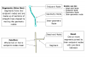


 Selected and editable segment junction
 Selected and uneditable segment junction (no permissions to change due to locks)
 Changed, unsaved junction