imported>Kentsmith9 (→Collector/distributor cloverleaf: clarified why ramps may look different from this and can be fixed to look this way.) |
imported>Kentsmith9 (Added category) |
||
| Line 1: | Line 1: | ||
The [[Waze Map Editor]] (WME) will periodically run into problems when trying to save information. Depending upon the error message you may need to do one of the following: 1) change what you last edited, 2) undo some number of prior edits, or 3) just reload the page and ignore the error. | |||
Generally it is best to save before you exceed 10 changes. This minimizes the problems you run into when one of the early changes in your edit sequence has a problem and you have to undo everything else after that in order to determine what out of all your edits is causing the problem. | |||
The alphabetical list of errors below will explain the reason for the error and provide suggested steps to rectify the issue. | |||
== An error occurred while saving == | |||
This is a general purpose error message that can occur for many reasons. Sometimes it is hard to identify specifically the problem. Here are some of the reasons you may run into this. | |||
=== Corrupt Roundabout === | |||
'''Explanation:''' Sometimes roundabouts get corrupted from prior edits making further changes very difficult. | |||
'''Solution:''' For simple parking lot roundabouts, it is usually fastest to delete the roundabout and recreate it with the changes you require. If it is part of a highway, deleting it will lose traffic flow history, so you may need to go to the forums for some troubleshooting assistance on the issue from more experienced editors. | |||
: | |||
'' | |||
=== {{anchor|Landmarks}}Places === | |||
'''Explanation #1:''' If editing a Place, there may be a problem with the address fields. | |||
'''Solution #1:''' Highlight the Place again and check the address with the Edit button. Look to be sure the Country, State, and City are all three set correctly. In some countries there may be less or different fields, but ensure they are correct. Sometimes the name can be misspelled and it is hard to notice. If the fields (like city name) exist in another area too far away from the Place, you will get this error. If you enter a location that does not exist anywhere, it will accept it, but that will not help when trying to search for that Place in the client app. | |||
: | '''Explanation #2:''' A Place cannot overlap any part of another place with the same name. | ||
'''Solution #2:''' Either change the name of the Place to not be exactly the same as the Place it overlaps, or adjust them to not overlap. | |||
=== Too many edits === | |||
: | '''Explanation:''' If you are saving a large number of edits at one time, sometimes the server is unable to respond back to your browser before it times out. This is common when using a script to make global changes to an area. | ||
'''Solution:''' Generally for this problem, the saves will likely go through, but you have to use the [[Waze Map Editor#Permalink|permalink]] button or reload the page with your browser. Check the area after the reload is complete to confirm the changes were saved, otherwise make them again in a smaller quantity of changes between saves. | |||
== The highlighted angle is not allowed in a road == | |||
''' | '''Explanation:''' There is an extremely sharp angle or "kink" in a new or changed segment. This can happen from you moving a junction or geometry node such that the segment doubles back on itself, or there is a bug in WME which can create this kink when a new junction is created. | ||
'''Solution:''' Delete any geometry nodes at the kink and/or adjust the junction so that there is no extremely sharp angle in any segment. | |||
: | |||
'' | '''Detailed examples:''' The following shows situations where you will encounter this error caused by the WME junction bug and by the user. Click on the thumbnail images to view them in full size if necessary. | ||
=== Junction Error === | |||
<gallery widths="250px" heights="250px"> | |||
Image:Highlighted_angle_junction1.jpg|Error on a junction | |||
Image:Highlighted_angle_junction2.jpg|Close-up on the error | |||
</gallery> | |||
This most often happens when you end drawing a new segment onto an existing segment: double-clicking to shift+click to end the segment drawing mode sometimes adds a geometry node extremely close to the ending junction node. | |||
{{clear}} | |||
=== Roundabout Error === | |||
<gallery widths="250px" heights="250px"> | |||
Image:Highlighted_angle_roundabout1.jpg|Error on a roundabout | |||
Image:Highlighted_angle_roundabout2.jpg|Close-up on the roundabout error | |||
</gallery> | |||
This also happens when connecting a segment onto an existing roundabout. WME has a bug which will junction onto the roundabout on the other side of an existing geometry node on the roundabout, which creates a kink in one of the roundabout segments. This occurs especially when connecting to an existing roundabout at [[Map_Editor_Interface_and_Controls#Scale|zoom level]] 6 or lower (higher elevation). | |||
{{clear}} | |||
=== Mid-segment Error === | |||
<gallery widths="250px" heights="250px"> | |||
Image:Highlighted_angle_segment1.jpg|Error in the middle of a segment | |||
Image:Highlighted_angle_segment2.jpg|Close-up doesn't quite show the problem yet | |||
Image:Highlighted_angle_segment3.jpg|Dragging a geometry node shows the error clearly | |||
Image:Highlighted_angle_segment4.jpg|Deleting one geometry node fixes this error | |||
</gallery> | |||
{{clear}} | |||
The | == The highlighted element was moved beyond the allowed distance == | ||
: | '''Explanation:''' When stretching or extending an already existing segment by dragging an endpoint, it cannot be extended more than about 3600 feet (1100 meters) at a time. | ||
'''Solution:''' If the segment must be extended, try extending it a shorter distance and save between each stretch. | |||
== The highlighted road is too far from the city it was added to == | |||
This can happen for two reasons. | |||
''' | '''Explanation #1:''' You may have just named a road with a city that already exists in the database, but is not anywhere near the location of the road. | ||
'''Solution #1:''' Go back and edit the road name or mark it as NONE. Save again. | |||
: | |||
'' | |||
'''Explanation #2:''' You may not have edited the name of a road, but you edited one of its properties and the road was originally imported into the database incorrectly. | |||
'''Solution #2:''' Edit the segment highlighted and fix the name of the city or state as necessary. | |||
== The highlighted segments are not connected by a node == | |||
'''Explanation:''' WME has identified two segments ends that are very close to one another, but are not actually joined. | |||
: | '''Solution:''' Move one or the other segment end get it to "snap" to the other segment end. Save again. You may need to move the segment which isn't connecting away from the junction, save, then move it back and save again. | ||
== While you were editing, the elements you're trying to save have been modified and/or deleted == | |||
: | '''Explanation:''' If you are saving a large number of edits at one time, sometimes the server is unable to respond back to your browser before it times out. This is common when using a script to make global changes to an area. | ||
'''Solution:''' Generally for this problem, the saves will likely go through, but you have to use the [[Waze Map Editor#Permalink|permalink]] button or reload the page with your browser. Check the area after the reload is complete to confirm the changes were saved, otherwise make them again in a smaller quantity of changes between saves. | |||
R | |||
== You have no permissions to make some of the changes == | |||
''' | '''Explanation #1:''' An area will be highlighted that reflects changes you are trying to make that are outside of your allowed [[Waze_Map_Editor#Editable_Area|Editable Area]]. There is a time limit for areas that you have driven. See the Editable Area link for more information. | ||
'''Solution #1.a:''' Turn on the [[Map_Editor_Interface_and_Controls#Editable_areas|layer for Editable Areas]] to check if you have permission to edit all of the segment in question. Sometimes segments can stretch outside of your reach. The layer highlight will help you see when that happens. If your driven area has expired you will need to drive there again, or consider applying to be an [[Area Manager]]. | |||
For Area Managers, you may be trying to edit outside of your allocated area as well. Use the above techniques to solve the problem. | |||
'''Solution #1.b:''' If an object needs to be edited outside of your area, you can always go to the [[Discussion Forums]] to post a request for assistance by a higher level editor who has permissions for the object. | |||
'''Explanation #2:''' Your login credentials have expired and must be reloaded by logging back in again. This typically happens when you have a browser tab open with the Waze Map Editor and your login expires after about a 24 hour period. | |||
'''Solution #2:''' Note the changes you made to the map. Press the [[Waze Map Editor#Permalink|Permalink]] button on the Waze Map Editor screen. You will receive a warning you will lose all information. At this point you have no choice and must accept leaving the page. After that the system will ask for you to log in again. Then you can make the changes again. | |||
[[ | |||
[[Category:Waze Map Editor]] | |||
Revision as of 01:28, 25 April 2014
The Waze Map Editor (WME) will periodically run into problems when trying to save information. Depending upon the error message you may need to do one of the following: 1) change what you last edited, 2) undo some number of prior edits, or 3) just reload the page and ignore the error.
Generally it is best to save before you exceed 10 changes. This minimizes the problems you run into when one of the early changes in your edit sequence has a problem and you have to undo everything else after that in order to determine what out of all your edits is causing the problem.
The alphabetical list of errors below will explain the reason for the error and provide suggested steps to rectify the issue.
An error occurred while saving
This is a general purpose error message that can occur for many reasons. Sometimes it is hard to identify specifically the problem. Here are some of the reasons you may run into this.
Corrupt Roundabout
Explanation: Sometimes roundabouts get corrupted from prior edits making further changes very difficult.
Solution: For simple parking lot roundabouts, it is usually fastest to delete the roundabout and recreate it with the changes you require. If it is part of a highway, deleting it will lose traffic flow history, so you may need to go to the forums for some troubleshooting assistance on the issue from more experienced editors.
Places
Explanation #1: If editing a Place, there may be a problem with the address fields.
Solution #1: Highlight the Place again and check the address with the Edit button. Look to be sure the Country, State, and City are all three set correctly. In some countries there may be less or different fields, but ensure they are correct. Sometimes the name can be misspelled and it is hard to notice. If the fields (like city name) exist in another area too far away from the Place, you will get this error. If you enter a location that does not exist anywhere, it will accept it, but that will not help when trying to search for that Place in the client app.
Explanation #2: A Place cannot overlap any part of another place with the same name.
Solution #2: Either change the name of the Place to not be exactly the same as the Place it overlaps, or adjust them to not overlap.
Too many edits
Explanation: If you are saving a large number of edits at one time, sometimes the server is unable to respond back to your browser before it times out. This is common when using a script to make global changes to an area.
Solution: Generally for this problem, the saves will likely go through, but you have to use the permalink button or reload the page with your browser. Check the area after the reload is complete to confirm the changes were saved, otherwise make them again in a smaller quantity of changes between saves.
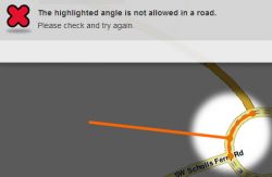
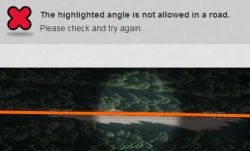
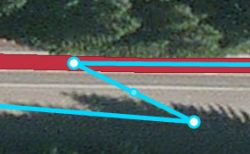
The highlighted angle is not allowed in a road
Explanation: There is an extremely sharp angle or "kink" in a new or changed segment. This can happen from you moving a junction or geometry node such that the segment doubles back on itself, or there is a bug in WME which can create this kink when a new junction is created.
Solution: Delete any geometry nodes at the kink and/or adjust the junction so that there is no extremely sharp angle in any segment.
Detailed examples: The following shows situations where you will encounter this error caused by the WME junction bug and by the user. Click on the thumbnail images to view them in full size if necessary.
Junction Error
-

Error on a junction
-

Close-up on the error


This most often happens when you end drawing a new segment onto an existing segment: double-clicking to shift+click to end the segment drawing mode sometimes adds a geometry node extremely close to the ending junction node.
Roundabout Error
-
Error on a roundabout
-

Close-up on the roundabout error


This also happens when connecting a segment onto an existing roundabout. WME has a bug which will junction onto the roundabout on the other side of an existing geometry node on the roundabout, which creates a kink in one of the roundabout segments. This occurs especially when connecting to an existing roundabout at zoom level 6 or lower (higher elevation).
Mid-segment Error
-
Error in the middle of a segment
-

Close-up doesn't quite show the problem yet
-
Dragging a geometry node shows the error clearly
-

Deleting one geometry node fixes this error


The highlighted element was moved beyond the allowed distance
Explanation: When stretching or extending an already existing segment by dragging an endpoint, it cannot be extended more than about 3600 feet (1100 meters) at a time.
Solution: If the segment must be extended, try extending it a shorter distance and save between each stretch.
The highlighted road is too far from the city it was added to
This can happen for two reasons.
Explanation #1: You may have just named a road with a city that already exists in the database, but is not anywhere near the location of the road.
Solution #1: Go back and edit the road name or mark it as NONE. Save again.
Explanation #2: You may not have edited the name of a road, but you edited one of its properties and the road was originally imported into the database incorrectly.
Solution #2: Edit the segment highlighted and fix the name of the city or state as necessary.
The highlighted segments are not connected by a node
Explanation: WME has identified two segments ends that are very close to one another, but are not actually joined.
Solution: Move one or the other segment end get it to "snap" to the other segment end. Save again. You may need to move the segment which isn't connecting away from the junction, save, then move it back and save again.
While you were editing, the elements you're trying to save have been modified and/or deleted
Explanation: If you are saving a large number of edits at one time, sometimes the server is unable to respond back to your browser before it times out. This is common when using a script to make global changes to an area.
Solution: Generally for this problem, the saves will likely go through, but you have to use the permalink button or reload the page with your browser. Check the area after the reload is complete to confirm the changes were saved, otherwise make them again in a smaller quantity of changes between saves. R
You have no permissions to make some of the changes
Explanation #1: An area will be highlighted that reflects changes you are trying to make that are outside of your allowed Editable Area. There is a time limit for areas that you have driven. See the Editable Area link for more information.
Solution #1.a: Turn on the layer for Editable Areas to check if you have permission to edit all of the segment in question. Sometimes segments can stretch outside of your reach. The layer highlight will help you see when that happens. If your driven area has expired you will need to drive there again, or consider applying to be an Area Manager.
For Area Managers, you may be trying to edit outside of your allocated area as well. Use the above techniques to solve the problem.
Solution #1.b: If an object needs to be edited outside of your area, you can always go to the Discussion Forums to post a request for assistance by a higher level editor who has permissions for the object.
Explanation #2: Your login credentials have expired and must be reloaded by logging back in again. This typically happens when you have a browser tab open with the Waze Map Editor and your login expires after about a 24 hour period.
Solution #2: Note the changes you made to the map. Press the Permalink button on the Waze Map Editor screen. You will receive a warning you will lose all information. At this point you have no choice and must accept leaving the page. After that the system will ask for you to log in again. Then you can make the changes again.