Nema sažetka uređivanja |
|||
| Redak 1: | Redak 1: | ||
== | ===Introduction=== | ||
Separate to the [[global:Map_Editor_Interface_and_Controls#Permission|lock system]] used to protect the map some features of the WME are restricted until you reach a certain [[global:Your_Rank_and_Points#Waze_Map_Editing_Rank|Editor Rank]]. The rank these features become available has been discussed and decided by the UK Country Admins. | |||
===Rank 2=== | |||
====Closing any URs, MPs==== | |||
*'''Location:''' Ensure the relevant options are visible in the layers menu. | |||
*'''Function:''' Allowed to close URs & MPs created by any users and themselves. | |||
====Deleting segments==== | |||
*'''Function:''' Allowed to delete any segment not created by themselves (respecting lock levels). | |||
====Approve Places==== | |||
*'''Location:''' Ensure that Place Update Requests are visible in the layers menu. | |||
*'''Function:''' Approve new or edited Places that have been submitted via Place Update Requests. | |||
[[File:Link-google-place.png|100px|thumbnail]] | |||
====Add Google linked place==== | |||
*'''Location:''' Within the Place's info panel under ''External Providers''. | |||
*'''Function:''' Links a Google Maps entry to the Waze Place to improve routing. | |||
[[ | ====Force House Numbers==== | ||
*'''Location:''' Within the House Number interface. | |||
*'''Function:''' When entering house number into the WME the system checks for errors like out of sequence, invalid numbers etc. Some of these [[global:House_Numbers_in_WME#Errors|can be forced saved]] if it is deliberate. | |||
[[ | ===Rank 3=== | ||
====Setting difficult turns==== | |||
*''''Location:'''' Within the [i]Time Based Restrictions[/i] screen for each turn arrow. | |||
*''''Function:'''' Marks a turn as ''difficult'', the App can be set to avoid these when routing. | |||
[[File:Add-closure-button.png|100px|thumbnail]] | |||
====Real time closures==== | |||
*'''Location:''' Within the segment's info panel under ''Closures'' tab. | |||
*'''Function:''' Allows [[global:Real_time_closures|real time closures]] to be set that are immediately live on the map. This still respects auto locks on segments. | |||
===Rank 4=== | |||
[[File:Snapshot-mode.png|100px|thumbnail]] | |||
====Snapshot mode==== | |||
*'''Location:''' Top left of WME window, above the user profile. | |||
*'''Function:''' Allows the editor to see the current live map to review changes made after the most recent tile update. | |||
====Create new city names==== | |||
*'''Location:''' Popup when unknown name is entered into the segment name field. | |||
*'''Function:''' Adds a new name to the City database. | |||
== | [[File:Routing-option.png|100px|thumbnail]] | ||
====Routing option==== | |||
*'''Location:''' Within segment side-panel below ''Road Type''. | |||
*'''Function:''' Upgrades / downgrades a segment without having to change it's Road Type. | |||
=== | ===Rank 5=== | ||
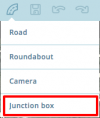
[[File:Junction-box.png|100px|thumbnail]] | |||
====Junction Boxes==== | |||
*'''Location:''' Within the [[File:DrawRoads.jpg|frameless|alt=add road]] menu. | |||
*'''Function:''' Allows better control of routing through complex junction. | |||
=== | |||
* | |||
[[ | |||
* | |||
Inačica od 25. ožujka 2018. u 09:31
Introduction
Separate to the lock system used to protect the map some features of the WME are restricted until you reach a certain Editor Rank. The rank these features become available has been discussed and decided by the UK Country Admins.
Rank 2
Closing any URs, MPs
- Location: Ensure the relevant options are visible in the layers menu.
- Function: Allowed to close URs & MPs created by any users and themselves.
Deleting segments
- Function: Allowed to delete any segment not created by themselves (respecting lock levels).
Approve Places
- Location: Ensure that Place Update Requests are visible in the layers menu.
- Function: Approve new or edited Places that have been submitted via Place Update Requests.

Add Google linked place
- Location: Within the Place's info panel under External Providers.
- Function: Links a Google Maps entry to the Waze Place to improve routing.
Force House Numbers
- Location: Within the House Number interface.
- Function: When entering house number into the WME the system checks for errors like out of sequence, invalid numbers etc. Some of these can be forced saved if it is deliberate.
Rank 3
Setting difficult turns
- 'Location:' Within the [i]Time Based Restrictions[/i] screen for each turn arrow.
- 'Function:' Marks a turn as difficult, the App can be set to avoid these when routing.

Real time closures
- Location: Within the segment's info panel under Closures tab.
- Function: Allows real time closures to be set that are immediately live on the map. This still respects auto locks on segments.
Rank 4

Snapshot mode
- Location: Top left of WME window, above the user profile.
- Function: Allows the editor to see the current live map to review changes made after the most recent tile update.
Create new city names
- Location: Popup when unknown name is entered into the segment name field.
- Function: Adds a new name to the City database.

Routing option
- Location: Within segment side-panel below Road Type.
- Function: Upgrades / downgrades a segment without having to change it's Road Type.
Rank 5
