DO NOT use Closures or Partial Restrictions for lane closures. Closures are only to be used when a segment is completely closed to all public through traffic temporarily. Partial Restrictions can be used when a segment is completely closed to specific types of vehicles.
Roads may be partially or completely closed in one or both directions for multiple reasons:
Road construction
Natural disasters
Local events
Also these instances may close a road for a few hours, days, weeks, and even years. Depending upon how long the road will be closed will determine what method is used to update the map.
This feature is restricted to rank 5 editors and above, unless otherwise decided by the local community.
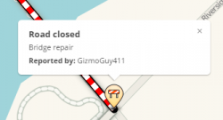
With this tool, closures can be entered directly in WME, and is visible almost immediately in the client and Livemap. It is displayed prominently on the map as a closure alert, and with red and white candy stripe lines along the closed segments. This feature allows editors to temporarily prevent routing over specific segments, without having to make any changes to, or damage those segments and their junctions.
If you do not have the required rank to access the Temporary Closure feature in WME, you can ask a higher ranking editor to do it for you. Your country may have a streamlined monitored process for this, or it can be submitted like any other unlock/update request. In the USA the Road Closures Form (USA) is used for example.NOTE: The maximum closure for a road can not exceed 183 days.
For road construction situations, refer to that article for additional specific information.
NOTE: If a segment is closed using this feature, the segment will not be editable by any editors - regardless of rank - while the closure is in effect. This is by design, to prevent any changes to segment and junction IDs which will corrupt the closure.
Local closure notifications for editors
Editors who are level 5 and above will receive notices when a closure is being supported by Waze. This means the closure will have a designate hashtag and additional information on the closure is available from the Waze team.
How to add a Temporary Closure in WME
This is the preferred method for closing roads due to its safety and visibility to the Wazers.
Select the segments you want to close.
Click the Add Closure button in the left panel.
Click to + Add Closure and fill out the fields shown:
Location- This field will auto-populate to name of affected street. If multiple streets are selected, add a general description of the area (name of the road, the interchange, or the area if several roads in a known area are being closed). This Section is NOT viewable in the client, only in the WME.
Reason - This field is viewable in both the client and the LiveMap. Enter the name of the event, or general cause of the closure. In the coming weeks, Waze will provide #hashtags for Major Traffic Events (MTE) which are submitted through the MTE Form.
Direction - Closure direction should be noted carefully. Close one way direction on a two way road here.
Event - Field is not currently active, please ignore.
Start/End Date & Time - Enter date/time the closure will remain active (this can be a date in the past). Enter local time for area of map you are editing. Format is 24-hour clock and YYYY-MM-DD. NOTE: End date can not be more than 183 days after the start date.
Save & Check in the live map. Active closures will appear with red closure icon, inactive closures will appear in grey.
Temporary Closure Guidance
The temporary closure tool is new to the WME. Here is some helpful guidance on the tool and how to use it best!
When to use the Temporary Closure tool
Hours, days, weeks
If the road is affected for only a few hours or even a few weeks then use the Report > Closure feature in the Waze client application. Note this requires a person be physically located at the point of the road closure to report it in the client application. Several people may need to report the closure for it to affect routing for all users. Alternately, the Temporary Closure can be added directly in WME (see below).
Days, weeks, months, years
WME has the ability to restrict traffic flow through a segment in one or both directions using the Temporary Closure feature.
Closing Multiple Segments
Temporary Closures can be added to multiple segments simultaneously by selecting all the affected segments first. Be careful to verify all the segments after you save that the Temporary Closure were added properly. It's been reported before when multiple Temporary Closures were added at once, that some of the segments either weren't closed, or had incorrect details in the closure (e.g. direction).
Segment direction for one-way closures
If only some of the segments are one-way, or some one-way segments are in opposing direction (B-A, A-B), you can set the Temporary Closure as two-way for all the segments. When you save you will see an error line for each direction of a closed segment which failed to save because the segment is one-way. You can ignore the error, and all your segments should be closed in all possible directions. (Be sure to double check them all.)
Closures not showing
Temporary Closures entered using this feature are not subject to waiting for a tile update, they will go live almost immediately. However, if you enter a Temporary Closure for a segment which has been modified enough (e.g. changed the segment ID, node ID, or junction location) since the last tile update, the Temporary Closure will not save until the new segment changes go live.
If entered through a Google Sheet the alerts will likely show in the new location of the nodes, but the candy stripe and routing effects won't be implemented until the segment changes are live.
To protect against this, if you try to close a new or modified segment before the tiles update, the closure will not save and WME will display an error (!) Element Segment with ID xxxxxxxx was not found (probably deleted). Wait till after the changes are included in a tile build, and then enter the closure again and it should save.
Editing sections with closures
The Temporary Closure system is based in the segment (and node) IDs, as a safety measure they will not be editable while there is a Temporary Closure added to the segment.'
If you need to edit the segment, you will have to first remove the Temporary Closure (copy the details first), then modify the segment, then add a new Temporary Closure with the details you copied to the appropriate segments.
Saving your work
A Temporary Closure can not be entered along with any other saves, similar to House Numbers. If you have any edits pending a save, and try to add a Temporary Closure you will get an error at the end. Be sure to save before trying to add a Temporary Closure.
Temporary Closures vs. Partial Restrictions
If a road is closed with a Temporary Closure, there is no need to duplicate the Temporary Closure with an additional Partial Restriction for travelling across the segment, or change any turn restrictions. (This also helps preserve the map, as soon as the Temporary Closure expires, the map will route as it's supposed to.)
Junctions and Cross traffic
When adding a Temporary Closure consider whether any cross traffic will be blocked as well.
If traffic going across your Temporary Closure at a junction must be blocked as well, you will need to close one of the cross street segments as well.
You should close the segment leading away from the Temporary Closure. If the cross street is a two way street, close only the shorter segment.
When closing a two way cross street segment, only set the Temporary Closure to the direction leading away from the Temporary Closure.
1.2.3.
Setting long-term closures
Temporary Closures must not be longer than 6 calendar months (183 days to be precise).
To enter a Temporary Closure longer than 6 months, split it into multiple Temporary Closures. Each Temporary Closure entered should be less than 6 months. E.g. A one year Temporary Closure from 2011-12-01 through 2015-11-30 can be entered as two individual Temporary Closures.
2014-12-01 - 2015-05-31 (182 days)
2015-06-01 - 2015-11-30 (183 days)
Start and end time settings
Be careful choosing closure times. 00:00 is the first minute of a day, 23:59 is the last minute of a day. A closure ending on Jan 1st at 00:00 will leave the road open for the entire day of Jan 1st, while 23:59 would leave the road closed for that entire day. To prevent ambiguity try using 00:01 instead of 00:00 as a closure time.
Temporary Closures are active for the full minute they are set for.
A Closure set for Start: 03:00 - End: 03:01, will actually be closed for 119 seconds, from 03:00:00 - 03:01:59.
A closure set for Start: 03:00, End: 04:00, will actually be closed for 60 minutes and 59 seconds, from 03:00:00 - 04:00:59.
Closure appearance
Usernames and closures
Adding a Temporary Closure does not put your name as the last editor for the segment (Updated By: user (#)), however you can see who added a closure by looking at the alert in livemap or the client. (You may find the WME LiveMap Alerts Overlay script useful for this, it will display the livemap alerts with the details in WME.)
LiveMap closures script
The WME LiveMap Closures script emphasizes closed segments with a red and white dashed line in WME for editors of all ranks.
Daily for certain times
If the road is closed every day or numerous days for a certain time of day, there are two possible solutions:
If your country has a closure sheet to submit closures through Waze staff, they can be entered using the sheet (and form). This functionality may be included in WME at a later time.
If your country does not have access to a closure sheet, it will require Partial restrictions, also known as Scheduled or Time based restrictions. You will have to wait for a tile update for the routing changes to take effect, so you may want to add a Temporary Closure from WME for the first couple of days. (Unless of course, you would like to, and are able to enter each days closure individually in WME, to take advantage of the visual benefits in the client and livemap.)
NOTES for all durations
The current time frame for map tile generation is every day on all map infrastructures. Due to when the map update cycle starts, changes to segments in Temporary Closures should be saved in the editor two days prior to the event.
Don't forget to edit the map back when the road partially or completely reopens.
If a road is closed, it should not be disconnected from the road network, unless it is never planned to be reopened. E.g. converted to pedestrian plaza, or demolished roads.
Changing the road direction to "Unknown" will not prevent routing on the road since this means to Waze that it should analyze drives along this segment and change the road direction automatically. This setting will allow Waze to create routes along the road as if it were a 2-way segment.
If one direction of a road is closed permanently, change the road direction to "One-Way" and also put a turn restriction as appropriate on junctions with the road.
There is no need to edit the map for lane closures.
If the road is slower than usual, Waze will learn the average road speed has fallen and make automatic Road reports. Routing will automatically be adjusted to account for the speed.
If there is an official detour route, Waze will learn about it as you drive it.
You should check that all surrounding roads are mapped properly and have correct directionality and connectivity so that Waze can find the best detour.
Ensuring the surrounding area roads are set to the appropriate road types will also help Waze find the best detours.
Waze routing includes a mechanism to prevent routing off a highway/freeway only to be routed right back on the same highway/freeway. The assumption is that drivers will prefer to remain on the highway/freeway even if waze calculates that taking a series of ramps or other collector/distributor roads is slightly faster or shorter.
Waze routing will reduce the chances of a detour off a highway/freeway and back on that same highway/freeway when all of the following conditions are met:
the last segment on the highway/freeway before the detour has the same street name and same city name as the next highway/freeway segment after the detour (the segments are considered to have the same name if either the primary name or alternate names are the same; unnamed segments are not considered as having the same name),
the detour is more than one segment long, and
the detour is under the threshold length as defined below.
Road Type
Threshold
Freeway
5km
Major Highway
5km
Minor Highway
500m
It is important to understand that Waze uses a penalty-based routing system. It computes the total penalties for a route and selects the one with the least cumulative penalty. Therefore it is possible for big detour routes to occur when the primary route is extremely slow.
Notes
For divided roadways that have the same name on both carriageways, the big detour prevention mechanism will prevent U-turns that traverse more than one segment. Thus in the intersection below, the configuration on the left will be used to route a U-turn because it uses a single segment between the two parallel roadways with the same name. In contrast, the configuration on the right will not use the U-Turn road because it branches from another segment causing multiple segments between the two parallel roads with the same name.
Be careful of "false positives!" For example, where route number concurrencies begin and end, the big detour mechanism may be unexpectedly triggered as follows (see diagram):
In a concurrency, two highways share the same road, and both names will appear on the concurrent segments, using Alternate names. Where the concurrency ends, the two highways split into separate roadways again.
Often, there are ramp segments connecting the last concurrent segment to one or both of the non-concurrent continuations. If the concurrency was of I-1234 and I-4567, for example, there might be a ramp named "to I-1234 / Sometown" - a name which contains "I-1234" but is not identical to the highway name.
If the ramp does not also carry a simple alternate name of "I-1234", then there is a discontinuity of the highway name between the concurrency and the continuation highway. If there are two ramp segments like this, it will trigger Big Detour Prevention unexpectedly, and Waze will create an unneeded penalty for continuing on I-1234.
To prevent this, just assign I-1234 as an alternate name to all ramps between the two sections (concurrency and continuation). Note that if there is only a single ramp segment connecting the highways, there will not be a "false positive." Nevertheless, it is a good practice to do this even for a single ramp segment, in case the ramp is cut into two segments later, either by accident or because later construction or map improvements connect another feeder ramp in the middle.
Another example of a false positive could occur where a highway has multiple wayfinders connected one to another (for example, if there are several multi-lane exits in a row).
Small Detours
Waze has a small detour prevention mechanism to deal with instances where Waze calculates that that a left turn can be "optimized" by using U-turns and right turns (either continue straight, U-turn, right turn; or alternatively, immediate right turn, U-turn, continue straight). While this may save a few seconds over waiting for a long average left turn, it is undesirable. Waze will prevent such detours if there is not a measurable difference in the route times. The exact difference in time required to trigger this prevention is proprietary, and subject to change as needed.


 2.
2.  3.
3.