This special page shows all uploaded files.
| Date | Name | Thumbnail | Size | Description | Versions |
|---|---|---|---|---|---|
| 13:24, 16 July 2015 | Map editors night 2015 colors 2.png (file) |  |
1.74 MB | 1 | |
| 21:12, 11 October 2015 | Map editors night 2015 colors 1.png (file) |  |
1.53 MB | New colors Oct 15 | 2 |
| 02:32, 11 November 2014 | MapRaid! NY.png (file) |  |
1.34 MB | 1 | |
| 23:24, 11 October 2015 | Color scheme Map Editors 2015 Colors 1.png (file) |  |
1.24 MB | Updated to Oct 15 colors | 2 |
| 14:50, 29 March 2015 | Rest area loop.png (file) |  |
1.02 MB | 1 | |
| 15:18, 14 July 2015 | Color scheme Map Editors 2015 Colors 2.png (file) |  |
923 KB | 1 | |
| 22:03, 10 July 2014 | PesachZ map editors 2.png (file) |  |
765 KB | 1 | |
| 21:51, 10 July 2014 | PesachZ map editors night 2.png (file) |  |
716 KB | 1 | |
| 23:55, 6 July 2014 | PesachZ map editors night.png (file) |  |
688 KB | 1 | |
| 06:03, 8 July 2014 | Night blue.png (file) |  |
687 KB | 1 | |
| 23:20, 11 October 2015 | PesachZ map editors.png (file) |  |
681 KB | Reverted to version as of 21:13, 6 July 2014 | 3 |
| 22:10, 4 January 2015 | Mapraid 15-01-Houston area.png (file) |  |
597 KB | 1 | |
| 16:17, 31 July 2014 | No BGS To exit.PNG (file) |  |
592 KB | 1 | |
| 17:38, 22 October 2015 | JB turn control 2.png (file) |  |
559 KB | 1 | |
| 17:38, 22 October 2015 | JB turn control 3.png (file) |  |
550 KB | 1 | |
| 17:47, 22 October 2015 | JB turn control 1.png (file) |  |
549 KB | 2 | |
| 17:39, 22 October 2015 | JB turn control 4.png (file) |  |
540 KB | 1 | |
| 17:40, 22 October 2015 | JB turn control.png (file) |  |
540 KB | 1 | |
| 16:19, 31 July 2014 | No BGS To exit zoom out.PNG (file) |  |
494 KB | 1 | |
| 21:37, 4 January 2015 | Houston.png (file) |  |
424 KB | 2 | |
| 10:16, 3 November 2014 | Rest area stop point.png (file) |  |
371 KB | 1 | |
| 14:53, 3 June 2014 | Exit right ramp to ramp.png (file) |  |
266 KB | Slight EXIT right ramp to ramp | 1 |
| 14:56, 3 June 2014 | Exit left ramp to ramp.png (file) |  |
266 KB | Slight exit left ramp to ramp | 1 |
| 20:49, 23 August 2016 | Avatar The look out.jpg (file) | 227 KB | 1 | ||
| 02:29, 17 September 2015 | Avatar PesachZ.jpg (file) | 227 KB | 1 | ||
| 19:00, 26 July 2015 | Route Checker.png (file) |  |
204 KB | 1 | |
| 14:38, 3 November 2014 | Place submission 1a.JPG (file) |  |
203 KB | 1 | |
| 20:48, 8 January 2015 | Clap Applause.png (file) |  |
193 KB | 1 | |
| 14:37, 3 June 2014 | Turn left angle.png (file) |  |
192 KB | Shallow angle left turn | 1 |
| 14:40, 3 June 2014 | Keep right ps to ramp.png (file) |  |
187 KB | Slight right turn from primary street to ramp | 1 |
| 14:44, 3 June 2014 | Keep left ps to ps bc.png (file) |  |
187 KB | Slight left primary street to primary street best continuation | 1 |
| 19:14, 7 September 2015 | Rest area loop turns2.png (file) |  |
172 KB | 2 | |
| 21:56, 17 July 2014 | Garminesque night.png (file) |  |
171 KB | 1 | |
| 01:19, 13 October 2015 | Avatar Howie2718.jpg (file) | 163 KB | 1 | ||
| 19:08, 7 September 2015 | Rest area loop turns1.png (file) |  |
161 KB | 1 | |
| 14:47, 3 November 2014 | Place submission 1b.jpg (file) |  |
149 KB | 1 | |
| 05:25, 2 May 2016 | Off button.png (file) |  |
144 KB | 1 | |
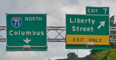
| 02:34, 29 July 2014 | Wayfinder continuation TO I-71.png (file) |  |
142 KB | The left branch of this wayfinder should be named "To I-71 N / Columbus" because after you pass it you are still on I-471. | 1 |
| 21:55, 17 July 2014 | Garminesque day.png (file) |  |
137 KB | 1 | |
| 00:39, 27 September 2015 | Avatar PhantomSoul.jpg (file) | 129 KB | 1 | ||
| 15:07, 3 June 2014 | Turn right.png (file) |  |
126 KB | Turn right major highway to street | 1 |
| 04:37, 14 April 2015 | DebugApp377.jpg (file) |  |
124 KB | 2 | |
| 23:36, 7 December 2014 | Clock.png (file) |  |
124 KB | 2 | |
| 17:29, 15 August 2014 | New York Counties.png (file) |  |
123 KB | 2 | |
| 14:34, 29 March 2015 | Rest area loop routing.JPG (file) |  |
121 KB | 1 | |
| 05:25, 2 May 2016 | On button.png (file) |  |
121 KB | 1 | |
| 17:20, 13 August 2014 | 3alertHow.PNG (file) |  |
119 KB | App v3.8.1.0 | 2 |
| 14:35, 3 June 2014 | Turn left agc.png (file) |  |
117 KB | A left turn to an AGC center turn lane with dogleg | 1 |
| 04:14, 25 April 2016 | Checklist.png (file) |  |
116 KB | 1 | |
| 14:37, 29 March 2015 | Rest area no loop instructions.JPG (file) |  |
111 KB | 1 |