Machete808 (talk | contribs) m (Copying text of wiki page for coparison with the "Arizona/Resources" page) |
Kartografer (talk | contribs) m (Copying text of wiki page for coparison with the "Cameras" page) |
||
| Line 1: | Line 1: | ||
<!-- | <!--if the section parameter is defined, do not place the visible banner, only as the code block for the top of a section-->{{GlobalMark/visible}} | ||
------ | <!-- | ||
#####-----#####-----#####-----#####-----#####-----#####-----#####-----#####----- | |||
#### This page has been curated #### | |||
#### to be included in the new #### | |||
#### Wazeopedia - GLOBAL Wiki. #### | |||
#### Please do not make any #### | |||
#### edits on this page without #### | |||
#### PRIOR CONSENSUS in the Wiki #### | |||
#### Updates and Discussions #### | |||
#### forum thread for this page. #### | |||
#### If a specific forum thread #### | |||
#### for this page doesn't exist #### | |||
#### please start one. #### | |||
#### www.waze.com/forum/ #### | |||
#### viewforum.php?f=276 #### | |||
#####-----#####-----#####-----#####-----#####-----#####-----#####-----#####--> | |||
{{UpdatedBanner|otherDate=2015/11/24|otherForum=http://www.waze.com/forum/viewtopic.php?f=276&t=127136#p1248120|otherSection=Adding Cameras}} | |||
Below are generic facts and use cases of the Waze camera types. Please see the following region-specific pages for more localized information: | |||
* [[United_Kingdom/Speed_Cameras|United Kingdom]] | |||
Waze supports numerous types of cameras and can provide client alerts when approaching a [[#Camera_Approval|validated camera installation]]. Also review the article on [[Map_Editing_Tips_and_Hints#Speed_cams|tips and hints for speed cameras]]. | |||
== Know your Cameras == | |||
''Also known as "What is '''NOT''' a Red Light Camera".'' | |||
Before adding any cameras to the Waze map, you must be sure you are accurately reporting a camera installation. Many devices may have similar appearances, but very different functions. | |||
The following devices all serve different purposes, but may all be installed at the same intersection. | |||
=== Signal Preemption Systems === | |||
[http://en.wikipedia.org/wiki/Traffic_signal_preemption Traffic signal preemption] is a type of system that allows the normal operation of traffic lights to be preempted, often to assist emergency vehicles. A very common system in the United States is the Opticom™ system by [http://www.gtt.com/ Global Traffic Technologies (GTT)]. | |||
These devices have a few things in common: | |||
# They are small and compact | |||
# They are mounted facing the traffic they are monitoring | |||
# They are typically mounted on the structures supporting the traffic signals | |||
:[[Image:Opticom1.jpeg]] [[Image:Opticom2.jpeg]] | |||
=== Traffic Cameras === | |||
[http://en.wikipedia.org/wiki/Traffic_camera Traffic cameras] monitor the flow of traffic or the depth of a queue waiting for a signal. They allow for automated optimization of traffic signal timing, real time monitoring by police and highway departments, and public feeds to news outlets and the Internet. | |||
These "cameras" may be video cameras, Radar transceivers, or a combination of the two. If Radar is used, it may trigger people's Radar Detectors and they may assume they are being monitored for speeding or other traffic violations although that is not the case unless additional camera equipment is also installed. Also note that some pedestrian cross walk equipment similarly uses Radar and may set off Radar Detectors. | |||
Traffic cameras have a few main things in common: | |||
# They are larger than Opticom type systems, but are still fairly compact | |||
# They may point in any direction depending on what they are monitoring | |||
: [[Image:Cam_traffic1.jpeg]] [[Image:Cam_traffic2.jpeg]] [[Image:Cam_traffic3.jpeg]] | |||
'''NOTE:''' Traffic cameras may be installed along side of Red Light Cameras to provide additional views of suspected violations. Be sure to validate the existence or absence of Red Light Camera equipment as well. | |||
=== | === Red Light Cameras (in general) === | ||
[http://en.wikipedia.org/wiki/Red_light_camera Red light cameras] monitor an intersection and trigger when traffic proceeds through the intersection on a red signal. One or more approaches to the intersection may be monitored. | |||
It is also common for a Red Light Camera installation to monitor for speed limit violations. | |||
Red light cameras have a few main things in common: | |||
< | # They have multiple lenses | ||
# They tend to be bulky<br />[[Image:RedLightCameraNYC.png|right]][[Image:Rlc_white.jpeg]] [[Image:Rlc_black.jpeg]]<br />[[Image:Rlc_gatso_rlc.jpeg]] [[Image:Rlc_gatso_US.png]] | |||
# They have an external flash (and possibly multiple flash units mounted on multiple poles)<br />[[Image:Rlc_flash_1.png]] | |||
# They have at least some equipment located behind the monitored intersection (there may be equipment on the other side of the intersection as well)<br />[[Image:Rlc_position.jpeg]] | |||
# They are clearly marked <br />[[Image:Rlc_sign1.jpeg]] [[Image:Rlc_sign2.jpeg]] [[Image:Rlc_sign3.jpeg]] [[Image:Rlc_sign4.png]] | |||
'''NOTE:''' There may be signs warning of Red Light Cameras for directions NOT monitored by cameras. See the discussion on [[#Camera_Placement|Camera Placement]] for details. | |||
=== | === Driver Feedback Signs === | ||
[http://en.wikipedia.org/wiki/Radar_speed_sign Driver Feedback signs] (a.k.a. radar speed sign, radar sign, Vehicle Activated Sign, Your Speed sign, traffic calming sign, etc.) can be either permanently installed or they may be mounted to a trailer which may be moved between locations. | |||
Don't confuse a Driver Feedback Sign with a "Speed Camera". Driver Feedback signs don't have a camera, therefore it is not a "Speed Camera". Driver Feedback signs also don't issue citations or tickets. | |||
: [[Image:Speed_feedback_perm.jpeg]] [[Image:Speed_feedback_trailer.jpeg]] | |||
'''NOTE:''' There may be a Driver Feedback Sign installed as part of a Speed Camera installation, but a Driver Feedback Sign alone is '''NOT''' a Speed Camera. | |||
=== Speed Cameras (in general) === | |||
[http://en.wikipedia.org/wiki/Speed_camera Speed Cameras] are devices which monitor traffic for vehicles exceeding a set maximum instantaneous speed or for exceeding a maximum average speed over a fixed distance. Detection may be facilitated with Radar or wire loops embedded in the road surface. | |||
They can be permanently installed or mounted temporarily. Temporary deployments include on trailers, hidden within vehicles, mounted to marked police vehicles, and handheld units. | |||
Permanent installations often use similar equipment as Red Light Cameras, including the ubiquitous yellow/orange Gatso in the UK. | |||
: [[Image:Rlc_gatso.jpeg]] [[Image:Rlc_truvelo_speed_cam.jpeg]] | |||
'''NOTE:''' Within Waze, the definition of a Speed Camera is limited to '''only permanent installations'''. See the [[#Speed_Cameras|Speed Cameras under Waze Camera Types]] section for details. | |||
== Waze Camera Types == | |||
The camera type is set and changed in the Map Editor by selecting the camera and changing the camera type in the drop down box in the [[Map_Editor_Interface_and_Controls#Left_Pane_when_a_Camera_is_selected|left pane]]. | |||
=== Speed Cameras === | |||
: [[Image:camera2false.png]] [[Image:camera2true.png]] | |||
These '''permanently mounted''' cameras monitor for instantaneous violations of maximum speeds. Systems that monitor average speed over a set distance (such as [http://en.wikipedia.org/wiki/SPECS_(speed_camera) SPECS]) are '''NOT''' supported at this time. | |||
If a Red Light Camera Installation monitors Speed Limit Violations, there is no need to add a separate Speed Camera. The speed limit can be applied directly to the Red Light Camera. See the section on [[#Camera_Speed|Camera Speed]] for details. | |||
'''NOTE:''' Temporary or portable Speed Camera installations should '''NEVER''' be reported in the client or added to the map. It takes from a few days to many weeks for a new camera to show up in the client application on people's phones. Therefore a movable camera will be long gone before anyone ever gets an alert about it. These non-permanent situations should be reported as a Police hazard for this reason. | |||
=== | === Red Light Cameras === | ||
: [[Image:camera4false.png]] [[Image:camera4true.png]] | |||
Please make sure you only report true Red Light Camera installations and do not confuse other device types. See [[#Know your Cameras|Know your Cameras]] above. | |||
If a Red Light Camera installation monitors for Speed Limit Violations as well, be sure the speed limit is set as described in the [[#Camera_Speed|Camera Speed]] section. | |||
=== | === Fake/Dummy Cameras === | ||
: [[Image:camera3false.png]] [[Image:camera3true.png]] | |||
It is common in the UK for authorities to install poles and enclosures for traffic enforcement camera which do not contain functional devices. | |||
==== | == Camera Placement == | ||
Cameras should be placed over the roadway they are monitoring. The exact location depends on the type of camera: | |||
* Speed Cameras should be placed at the location of the camera itself. | |||
* Red Light Cameras should be placed at the stop bar they are monitoring. | |||
* | Also be sure to place the correct quantity of cameras: | ||
* If a Speed Camera monitors one direction of traffic, you need one camera. | |||
* If a Speed Camera monitors both directions of traffic, you need TWO cameras. | |||
* You need one Red Light Camera per monitored direction. So if you have a 4-way intersection with camera watching every direction, you need FOUR cameras. (See note below.) | |||
'''NOTE:''' It is common to have signs warning of red light cameras at all approaches to the intersection although only a subset of those approaches may be monitored. For example, there may be signs on all 4 approaches to a 4-way intersection even if 3, 2, or even only 1 of the directions is actually monitored by a camera. Only the directions which are actually monitored by cameras should be added to the map. | |||
=== Shutter Direction === | |||
When the camera icon is selected in the Map Editor, the red dot should point in the direction of travel a car will '''pass''' the camera. It does not matter if the real-life camera will take a picture of the front of the offending vehicle. | |||
For example, if a road runs east-west and the east bound lanes are monitored for speed, the red dot should point eastward of the camera icon in the Map Editor. Be sure the angle of the red dot also matches the angle of the flow of monitored traffic. | |||
Where a camera records a turn during a red signal, the monitored direction is the starting road even though the camera faces the road onto which you turn. | |||
==== | === Adding Cameras === | ||
====From The App==== | |||
Cameras of all types can be added to the map from the client application. You must be driving past the location of the camera installation (preferably on the correct road and in the correct direction) to issue this report. | |||
Once you have submitted the camera report, it will appear on your client screen (and yours ONLY). Once that day's drives have been processed by the Waze servers, the camera will appear in the Map Editor where it can be approved. It must be approved for other drivers to be alerted of its presence. | |||
==== | ====From The Map Editor==== | ||
Cameras of all types can be added to the map from the Map Editor. Cameras are added by selecting camera from the [[Map_Editor_Interface_and_Controls#Draw_segments_menu|draw segments menu]]. In some countries the ability to add a camera is restricted to editors of advanced rank. | |||
=== Moving Cameras === | |||
If a reported camera is not in quite the right location, it can be moved within the Map Editor. | |||
When you click on the camera icon, a circle appears; the camera can be moved anywhere within that circle. (After saving, you will be able to move the camera again within a re-centered circle.) Take care to ensure the red dot is facing in the proper direction after moving a camera. | |||
== Camera Speed == | |||
< | <!--related: https://wiki.waze.com/wiki/Map_Editor_Interface_and_Controls#Draw_segments_menu--> | ||
The Max Speed for a camera should be set to the speed limit for the road which the speed camera is monitoring. | |||
The Max Speed can also be set for a Red Light Camera if it monitors for speed limit violations as well as red light violation. Leave the max speed set to blank if speed is not monitored. Zero is not blank; a max speed of zero will cause the camera to always generate an audible alert as discussed below. | |||
While a Red Light Camera will always give an alert in the client as a driver approaches, a Speed Camera will always show a pop-up alert, but will only generate an audible alert if the driver is '''exceeding''' the set Speed Limit as they approach the camera. | |||
[[Image:camera2true.png|right]] {{Red|'''NOTE:''' The icon in the editor for a Speed Camera shows the number 30 but that does NOT have anything to do with the actual speed set for the camera.}} | |||
== Camera Approval == | |||
All cameras must be approved in the Map Editor in order to appear in the client application. Once approved, the map tiles must be updated for this change to propagate out to the users. However, the approval itself will not trigger the tile update, so make sure that some other edit to the nearby roads is made so that the tile will be sure to update. | |||
The [[Your_Rank_and_Points#Map_editing_rank|Editing Rank]] of the editor who approves the camera is used in determining how many reports of "Not There" from the client are required to remove a camera. See the [[#From_the_Client|Camera Removal, From the Client]] section below. | |||
== Camera Removal == | |||
=== From the Client === | |||
{{Red|The following applies only to countries outside the United States and Canada. Within the United States and Canada, the "Not There" function in the app has no effect on cameras.}} | |||
When a driver receives a camera alert there is a "Not There" button in the client. This button will not instantly remove the camera, but submits a "vote" that the camera should be removed. | |||
Each time a Wazer uses the "Not There" button for a specific camera, a number of votes equal to that Wazer's current [[Your_Rank_and_Points#Map_editing_rank|Editing Rank]] is submitted. Each time a Wazer passes the camera they can submit their votes. Votes are counted once the driving session during which the vote was cast is processed by the Waze servers. | |||
'''NOTE:''' Wazers with an Editing Rank of zero (0) submit zero votes so their "Not There" reports are in effect ignored. | |||
Once the number of votes submitted is equal to or exceeds the [[Your_Rank_and_Points#Map_editing_rank|Editing Rank]] of the Wazer who approved the camera, the camera will be '''demoted''' to an un-approved camera. No change will be made in the client until Map Tiles are re-processed after the demotion and those updated tiles are made available to and downloaded by the client. | |||
From the Map Editor an editor may delete the now-unapproved camera or it may be approved again. | |||
'''NOTE:''' Each vote by each Wazer is counted, so a Wazer with a level 1 Editing Rank can demote a camera approved by a level 5 editor by reporting "Not There" every day for a week. | |||
=== From the Editor === | |||
Cameras are "locked" to the Editor rank of the approving editor. An editor must be at least the same rank as the approving editor to delete an approved camera. An unapproved camera does not have this restriction. | |||
Cameras can be removed in the same manner as other map elements in the Editor -- select the camera and press the trash can icon in the menu bar. Once deleted, the [[map tile update|map tiles must be updated]] for this change to propagate out to the users. However, the deletion itself will not trigger the tile update, so make sure that some other edit to the nearby roads is made so that the tile will be sure to update. | |||
Be sure you have confirmed the camera is not present and if there are multiple cameras in the area, be sure you are deleting the correct one. | |||
'''NOTE:''' Unapproved cameras appear in the editor for about three weeks and then are automatically discarded by the system. Therefore it is not necessary to spend time removing unapproved cameras from the map. | |||
== Legality of cameras == | |||
As country specific legality information is added to the Wiki, it will be linked below. | |||
<!--Insert countries in alphabetical order with English spelling first | |||
followed by localized spelling next if desired.--> | |||
* [[United Kingdom/Speed Cameras|United Kingdom]] | |||
* [[Cameras/Legality/USA|USA]] | |||
[[Category:Waze Map Editor]] | |||
Revision as of 19:48, 10 November 2016

| The last notable change to this page was in "Adding Cameras" on 24 November 2015. |
Below are generic facts and use cases of the Waze camera types. Please see the following region-specific pages for more localized information:
Waze supports numerous types of cameras and can provide client alerts when approaching a validated camera installation. Also review the article on tips and hints for speed cameras.
Know your Cameras
Also known as "What is NOT a Red Light Camera".
Before adding any cameras to the Waze map, you must be sure you are accurately reporting a camera installation. Many devices may have similar appearances, but very different functions.
The following devices all serve different purposes, but may all be installed at the same intersection.
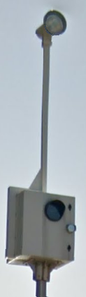
Signal Preemption Systems
Traffic signal preemption is a type of system that allows the normal operation of traffic lights to be preempted, often to assist emergency vehicles. A very common system in the United States is the Opticom™ system by Global Traffic Technologies (GTT).
These devices have a few things in common:
- They are small and compact
- They are mounted facing the traffic they are monitoring
- They are typically mounted on the structures supporting the traffic signals


Traffic Cameras
Traffic cameras monitor the flow of traffic or the depth of a queue waiting for a signal. They allow for automated optimization of traffic signal timing, real time monitoring by police and highway departments, and public feeds to news outlets and the Internet.
These "cameras" may be video cameras, Radar transceivers, or a combination of the two. If Radar is used, it may trigger people's Radar Detectors and they may assume they are being monitored for speeding or other traffic violations although that is not the case unless additional camera equipment is also installed. Also note that some pedestrian cross walk equipment similarly uses Radar and may set off Radar Detectors.
Traffic cameras have a few main things in common:
- They are larger than Opticom type systems, but are still fairly compact
- They may point in any direction depending on what they are monitoring


NOTE: Traffic cameras may be installed along side of Red Light Cameras to provide additional views of suspected violations. Be sure to validate the existence or absence of Red Light Camera equipment as well.
Red Light Cameras (in general)
Red light cameras monitor an intersection and trigger when traffic proceeds through the intersection on a red signal. One or more approaches to the intersection may be monitored.
It is also common for a Red Light Camera installation to monitor for speed limit violations.
Red light cameras have a few main things in common:
- They have multiple lenses
- They tend to be bulky
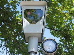

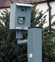
- They have an external flash (and possibly multiple flash units mounted on multiple poles)
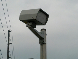
- They have at least some equipment located behind the monitored intersection (there may be equipment on the other side of the intersection as well)

- They are clearly marked
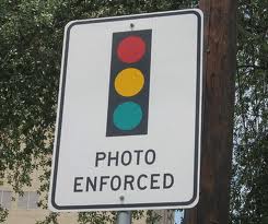

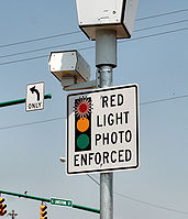


NOTE: There may be signs warning of Red Light Cameras for directions NOT monitored by cameras. See the discussion on Camera Placement for details.
Driver Feedback Signs
Driver Feedback signs (a.k.a. radar speed sign, radar sign, Vehicle Activated Sign, Your Speed sign, traffic calming sign, etc.) can be either permanently installed or they may be mounted to a trailer which may be moved between locations.
Don't confuse a Driver Feedback Sign with a "Speed Camera". Driver Feedback signs don't have a camera, therefore it is not a "Speed Camera". Driver Feedback signs also don't issue citations or tickets.


NOTE: There may be a Driver Feedback Sign installed as part of a Speed Camera installation, but a Driver Feedback Sign alone is NOT a Speed Camera.
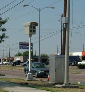
Speed Cameras (in general)
Speed Cameras are devices which monitor traffic for vehicles exceeding a set maximum instantaneous speed or for exceeding a maximum average speed over a fixed distance. Detection may be facilitated with Radar or wire loops embedded in the road surface.
They can be permanently installed or mounted temporarily. Temporary deployments include on trailers, hidden within vehicles, mounted to marked police vehicles, and handheld units.
Permanent installations often use similar equipment as Red Light Cameras, including the ubiquitous yellow/orange Gatso in the UK.


NOTE: Within Waze, the definition of a Speed Camera is limited to only permanent installations. See the Speed Cameras under Waze Camera Types section for details.
Waze Camera Types
The camera type is set and changed in the Map Editor by selecting the camera and changing the camera type in the drop down box in the left pane.
Speed Cameras

These permanently mounted cameras monitor for instantaneous violations of maximum speeds. Systems that monitor average speed over a set distance (such as SPECS) are NOT supported at this time.
If a Red Light Camera Installation monitors Speed Limit Violations, there is no need to add a separate Speed Camera. The speed limit can be applied directly to the Red Light Camera. See the section on Camera Speed for details.
NOTE: Temporary or portable Speed Camera installations should NEVER be reported in the client or added to the map. It takes from a few days to many weeks for a new camera to show up in the client application on people's phones. Therefore a movable camera will be long gone before anyone ever gets an alert about it. These non-permanent situations should be reported as a Police hazard for this reason.
Red Light Cameras


Please make sure you only report true Red Light Camera installations and do not confuse other device types. See Know your Cameras above.
If a Red Light Camera installation monitors for Speed Limit Violations as well, be sure the speed limit is set as described in the Camera Speed section.
Fake/Dummy Cameras


It is common in the UK for authorities to install poles and enclosures for traffic enforcement camera which do not contain functional devices.
Camera Placement
Cameras should be placed over the roadway they are monitoring. The exact location depends on the type of camera:
- Speed Cameras should be placed at the location of the camera itself.
- Red Light Cameras should be placed at the stop bar they are monitoring.
Also be sure to place the correct quantity of cameras:
- If a Speed Camera monitors one direction of traffic, you need one camera.
- If a Speed Camera monitors both directions of traffic, you need TWO cameras.
- You need one Red Light Camera per monitored direction. So if you have a 4-way intersection with camera watching every direction, you need FOUR cameras. (See note below.)
NOTE: It is common to have signs warning of red light cameras at all approaches to the intersection although only a subset of those approaches may be monitored. For example, there may be signs on all 4 approaches to a 4-way intersection even if 3, 2, or even only 1 of the directions is actually monitored by a camera. Only the directions which are actually monitored by cameras should be added to the map.
Shutter Direction
When the camera icon is selected in the Map Editor, the red dot should point in the direction of travel a car will pass the camera. It does not matter if the real-life camera will take a picture of the front of the offending vehicle.
For example, if a road runs east-west and the east bound lanes are monitored for speed, the red dot should point eastward of the camera icon in the Map Editor. Be sure the angle of the red dot also matches the angle of the flow of monitored traffic.
Where a camera records a turn during a red signal, the monitored direction is the starting road even though the camera faces the road onto which you turn.
Adding Cameras
From The App
Cameras of all types can be added to the map from the client application. You must be driving past the location of the camera installation (preferably on the correct road and in the correct direction) to issue this report.
Once you have submitted the camera report, it will appear on your client screen (and yours ONLY). Once that day's drives have been processed by the Waze servers, the camera will appear in the Map Editor where it can be approved. It must be approved for other drivers to be alerted of its presence.
From The Map Editor
Cameras of all types can be added to the map from the Map Editor. Cameras are added by selecting camera from the draw segments menu. In some countries the ability to add a camera is restricted to editors of advanced rank.
Moving Cameras
If a reported camera is not in quite the right location, it can be moved within the Map Editor.
When you click on the camera icon, a circle appears; the camera can be moved anywhere within that circle. (After saving, you will be able to move the camera again within a re-centered circle.) Take care to ensure the red dot is facing in the proper direction after moving a camera.
Camera Speed
The Max Speed for a camera should be set to the speed limit for the road which the speed camera is monitoring.
The Max Speed can also be set for a Red Light Camera if it monitors for speed limit violations as well as red light violation. Leave the max speed set to blank if speed is not monitored. Zero is not blank; a max speed of zero will cause the camera to always generate an audible alert as discussed below.
While a Red Light Camera will always give an alert in the client as a driver approaches, a Speed Camera will always show a pop-up alert, but will only generate an audible alert if the driver is exceeding the set Speed Limit as they approach the camera.

NOTE: The icon in the editor for a Speed Camera shows the number 30 but that does NOT have anything to do with the actual speed set for the camera.
Camera Approval
All cameras must be approved in the Map Editor in order to appear in the client application. Once approved, the map tiles must be updated for this change to propagate out to the users. However, the approval itself will not trigger the tile update, so make sure that some other edit to the nearby roads is made so that the tile will be sure to update.
The Editing Rank of the editor who approves the camera is used in determining how many reports of "Not There" from the client are required to remove a camera. See the Camera Removal, From the Client section below.
Camera Removal
From the Client
The following applies only to countries outside the United States and Canada. Within the United States and Canada, the "Not There" function in the app has no effect on cameras.
When a driver receives a camera alert there is a "Not There" button in the client. This button will not instantly remove the camera, but submits a "vote" that the camera should be removed.
Each time a Wazer uses the "Not There" button for a specific camera, a number of votes equal to that Wazer's current Editing Rank is submitted. Each time a Wazer passes the camera they can submit their votes. Votes are counted once the driving session during which the vote was cast is processed by the Waze servers.
NOTE: Wazers with an Editing Rank of zero (0) submit zero votes so their "Not There" reports are in effect ignored.
Once the number of votes submitted is equal to or exceeds the Editing Rank of the Wazer who approved the camera, the camera will be demoted to an un-approved camera. No change will be made in the client until Map Tiles are re-processed after the demotion and those updated tiles are made available to and downloaded by the client.
From the Map Editor an editor may delete the now-unapproved camera or it may be approved again.
NOTE: Each vote by each Wazer is counted, so a Wazer with a level 1 Editing Rank can demote a camera approved by a level 5 editor by reporting "Not There" every day for a week.
From the Editor
Cameras are "locked" to the Editor rank of the approving editor. An editor must be at least the same rank as the approving editor to delete an approved camera. An unapproved camera does not have this restriction.
Cameras can be removed in the same manner as other map elements in the Editor -- select the camera and press the trash can icon in the menu bar. Once deleted, the map tiles must be updated for this change to propagate out to the users. However, the deletion itself will not trigger the tile update, so make sure that some other edit to the nearby roads is made so that the tile will be sure to update.
Be sure you have confirmed the camera is not present and if there are multiple cameras in the area, be sure you are deleting the correct one.
NOTE: Unapproved cameras appear in the editor for about three weeks and then are automatically discarded by the system. Therefore it is not necessary to spend time removing unapproved cameras from the map.
Legality of cameras
As country specific legality information is added to the Wiki, it will be linked below.