|
|
| Line 1: |
Line 1: |
| {{Template:UpdateToStateTemplate|USA/Southeast/Test}}
| | <!-- This page is only viewed directly through a link from the state's "unique portion" page. Content on this page will be viewed in its entirety.--><noinclude>{{:USA/CommonState/ReturnPurge|{{SubPage2}}}}<br/></noinclude><!-- |
| This page contains information related to editing Waze maps in the USA Southeast Region which includes '''Alabama''', '''Florida''', and '''Georgia'''. It takes precedence over any more geographically localized state-level sub-pages to insure regional unity and consistency. Your regional coordinator is [http://www.waze.com/forum/ucp.php?i=pm&mode=compose&u=2686507 driving79]. Questions regarding this information should be addressed to the [[Southeast#Key_Southeast_Region_Editors | SE Regional Coordinator or the State Managers]]. | | ------ DO NOT MODIFY ABOVE THIS LINE -------- DO NOT MODIFY ABOVE THIS LINE ------> |
|
| |
|
| To get in contact with the Southeast editors please fill out '''[https://docs.google.com/forms/d/e/1FAIpQLSfVWTsFnjliYmrTW39fWOMAiXVAX8_8Au6DL71WB3fvEWYFaA/viewform?c=0&w=1 USA Regions Slack Invite Form]''', and join the Slack team. We'd love to hear from you!
| | {{AddCode|We are so glad you decided to join us in improving the Waze Map in West Virginia. Here are some things that will make your Map Editing experience a little easier (and hopefully more enjoyable). [http://www.youtube.com/watch?v{{=}}UHKdgZmVYN0&feature{{=}}youtu.be Click here for a recent Webinar Intro to Map Editing]}} |
|
| |
|
| '''[http://www.waze.com/forum/viewforum.php?f=944 US Southeast]''' is our Waze forum.
| | === Introduction to Map Editing Webinar === |
|
| | Click here for an [http://www.youtube.com/watch?v=UHKdgZmVYN0&feature=youtu.be Introduction to Map Editing Webinar] |
| This page is maintained by the [[Southeast#Key_Southeast_Region_Editors | Key Southeast Region Editors]] and moderated by [http://www.waze.com/forum/ucp.php?i=pm&mode=compose&u=2686507 driving79]. <span style="color:#4b0082;">Please coordinate any changes in advance</span>. Southeast map editors are encouraged to add/modify their own information in the '''[[Southeast#Key_Southeast_Region_Editors | Key Southeast Region Editors]]''' table below. <span style="color:#0000cd;">All editors should be intimately familiar with [[Best_map_editing_practice|Best Editing Practices]].</span>
| |
|
| |
|
| <span style="color:#0000cd;">'''[[USA/Southeast/Meetup 2016|SER Meetup 2016]]'''</span>
| | === WV GHO === |
|
| |
|
| <span style="color:#0000cd ;">'''[[USA/Southeast/Meetup_2017|SER Meetup 2017]]'''</span>
| | [[File:Wazebot.png]] |
|
| |
|
| | We have created a Google Hangout (GHO) just for West Virginia. The GHO is where you can go to interact and chat with fellow editors along with your Area and State Managers. It will give you good insight into the best practices and policies in regard to map editing plus give an easy, convenient way for editors to stay in touch, ask questions (any questions, we all started at Rank #1 at some point), request downlocks or review of your work and get Peer-to-Peer Mentoring. |
|
| |
|
| | If you are editing in West Virginia and have not done so; please join us on the WV Editor Hangout. You can join easily with [http://docs.google.com/forms/d/e/1FAIpQLSdGds9PsBtOEfvtdFGVEgTxHaS7-sQZ2_XiXcvX869MKq5SAA/viewform this link]. |
|
| |
|
| '''Additionally, important links for all Southeast editors are available at | | === Waze Bot === |
| | Once you join, Type ''!wb help'' in the WV GHO. This will get you started with Wazebot (wb); Wazebot will send you some help. In a DM (Direct Message or conversation) window with the wazebot overlord: |
|
| |
|
| [[USA/Southeast/Important_Links| Southeast's Important Links Page]].'''
| | : Say hello to the WazeBot. Then back in the WV GHO, type hello @xxxxx (where xxxx is your username. This procedure is necessary to let the bot know you're alive ;P No seriously, the above steps are required to authorize two-way communication between the bot and your own account. |
|
| |
|
| == States, Counties and Localities ==
| | Also you should set up the following: |
|
| |
|
| === Alabama ===
| | : !wb setnickname xxxxxx |
| | : !wb subscribe yyyyyyy |
| | :: You can subscribe to multiple keywords, names, etc. |
|
| |
|
| [https://greasyfork.org/en/scripts/11423-wme-counties-alabama-census-2014 WME Counties Alabama Census 2014]
| | For example, if your waze editor name is ''pittsburgsteelersfaninwv'', you can set your nickname to be '''SteelersFan''' by using '''!wb setnickname SteelersFan'''. Then people can ping you by using @SteelersFan. |
|
| |
|
| *'''Overview:''' There are 426 municipalities and 67 counties in the state. The primary urban centers are Birmingham, Mobile, Montgomery (state capitol), and Huntsville, all pierced by or nearby the I-65 corridor. The toll system is [http://www.tollfinder.com/states/AL/ Freedom Pass]. Alabama is in the Central time zone.
| | If your real name is ''Marcus Aurelius'', you can use '''!wb subscribe Marc''' and people can ping you by just using the work "Marc" and won't have to use the @ preface. You can also subscribe to other keywords such as downlock, mapraid, etc. Just continue to subscribe to the bot. |
|
| |
|
| === Florida ===
| | If some of the abbreviations and terms used are not clear, you can also use the wazebot to lookup terms for you. In a DM with wazebot, type '''!wb glossary [''word'']''' and the bot will send you some definitions. |
|
| |
|
| *'''Overview:''' There are 473 municipalities and 67 counties in the state. Orlando and neighboring Lake Buena Vista endure the most editing and map reports due to their popularity as global tourist destinations. The toll system is "[http://www.sunpass.com Sunpass]" ([http://www.floridasturnpike.com/TollCalcV3/index.htm toll rates]) and it is near impossible to travel anywhere in Florida from Orlando southward without encountering it. Outside of Florida, it is compatible with the [http://www.myncquickpass.com NC QuickPass], and the GA PeachPass (see below). Florida spans the Eastern and Central time zones, with the dividing line at the Apalachicola River west of Tallahassee.
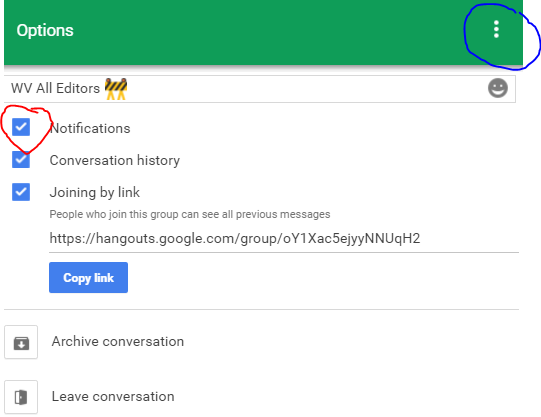
| | If the notifications on your phone or computer get to be too much, in the WV GHO you can select the “3 dots” (circled in Blue), Select “Options” and turn off notifications if you do not want to be disturbed; Just uncheck the box. |
|
| |
|
| *''' Disney World:''' Disney World has been edited and locked to rank 5 for segments and rank 6 for areas/points. If you see an issue anywhere in Disney World, please post it to the [http://www.waze.com/forum/viewforum.php?f=199 unlock request forum], or alert a rank 5 or 6 editor with the problem and it will be fixed.
| | '''Please do not modify/change any of the other options; they affect everyone.''' |
|
| |
|
| === Georgia ===
| | [[File:GHO options.png]] |
|
| |
|
| *'''Overview:''' There are 523 municipalities and 159 counties in the state. The toll system is [http://www.peachpass.com/ PeachPass] and is primarily found on HOV lanes in metro Atlanta. Some HOV lanes ''require'' PeachPass. Outside of Georgia, it is compatible with the FL Sunpass, and the [http://www.myncquickpass.com NC QuickPass]. Georgia is in the Eastern time zone.
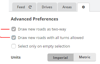
| | === WME (Waze Map Editor) Settings === |
|
| |
|
| == Road (segment) types ==
| | First thing in the Editor, Select the “gear” icon and enable the first two checkboxes: |
|
| |
|
| Determining road types in the Southeast aligns with the Waze '''[[Road_types/USA|USA Standard]]''' for freeway, major highway, minor highways, and primary streets. The Waze USA standard is a hybrid system based on a national standard called "functional classification" with a few modifications.
| | [[File:WME options.png]] |
|
| |
|
| '''[[National_resources/USA/Functional_classification|Functional classification maps]]''' are available for most states. Compliance across state borders is important to insure better route selections between states; however, editors in some states have deferred adoption of the '''[[Road_types/USA|USA Standard]]''' due to in-state concerns. If you edit in any region than the Southeast, you must comply with that '''[[Mapping_resources/USA|state's recommendations]]'''.
| | === Add Ins and Scripts === |
|
| |
|
| Although the Waze '''[[Road_types/USA|USA Standard]]''' permits some road-type selection deviation, at present no Southeast deviations are permitted, but may be in the future.
| | The Waze Community has created extensions and scripts to make editing a little easier and to help spot errors. The following should be installed. Chrome is the recommended browser but FireFox works as well. |
|
| |
|
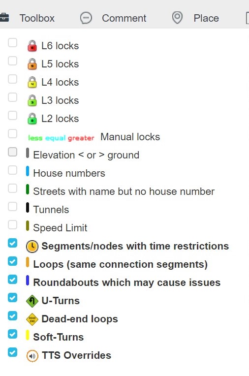
| === Minimum Road Type Standards === | | ==== Toolbox ==== |
| | This script will highlight some errors that are very common, especially with new editors. Go here to install: [[Scripts/WME_Toolbox|Toolbox]] |
|
| |
|
| * Interstate = {{freeway}}
| | Once you have installed Toolbox, press the Toolbox Icon and select the following options: |
| * US Hwy = {{Major Highway}} (MH)
| |
| * State Roads = {{Minor Highway}} (mH)
| |
|
| |
|
| === Dirt (unpaved/gravel) roads ===
| | [[File:Tb options.JPG]] |
|
| |
|
| The USA Standard ([[Road_types/USA#FC_cross_reference|matrix table]]) does not specify how to set unpaved road segments, so we define that here. Unpaved roads may or may not be classified in the states' functional classification system. If they are, set the road type according to the functional classification. If they are not, set the road type to Dirt Road / 4x4 Trail.
| | ==== TamperMonkey (Chrome) and GreaseMonkey (Firefox) ==== |
| | You will need this to install the additional scripts. [[Scripts#General_installation_instructions|Install TamperMonkey or GreaseMonkey]] |
|
| |
|
| To stay aligned with the USA Standard, a County Road functionally classified as Local, or a Local street classified as a collector, is still to be set as a Primary Road. A Local street functionally classified by the DOT as Local, is a Street. ''Otherwise, dirt is dirt.'' The majority of dirt roads are not functionally classified.
| |
|
| |
|
| {| border="1" cellspacing="0" cellpadding="0" align="center"
| | ==== Validator ==== |
| |-
| | Tool for highlighting additional errors. Please see [http://www.waze.com/forum/viewtopic.php?t=76488 Validator] for installation information for Chrome or Firefox users. |
| | colspan="2" rowspan="2" style="vertical-align: top; text-align: center;" | <span style="font-size:smaller;">'''How to determine<br/>when to set a dirt<br/>road as type<br/>dirt road'''</span>
| |
| | colspan="2" | <p style="text-align: center;"><span style="color:#4b0082;">'''Dirt<br/>(unpaved or gravel)'''</span></p>
| |
| |-
| |
| | <p style="text-align: center;"><span style="font-size:smaller;"><span style="color:#4b0082;">County<br/>Road</span></span></p>
| |
| | <p style="text-align: center;"><span style="font-size:smaller;"><span style="color:#4b0082;">Street</span></span></p>
| |
| |-
| |
| | rowspan="3" style="width:27px;" | <p style="text-align: center;"><span style="color:#4b0082;">'''Functional<br/>Class'''</span></p>
| |
| | <p style="text-align: center;"><span style="color:#4b0082;">Collector</span></p>
| |
| | <p style="text-align: center;">{{Primary Street|PS}}</p>
| |
| | style="text-align: center;" | {{Primary Street|PS}}
| |
| |-
| |
| | <p style="text-align: center;"><span style="color:#4b0082;">Local</span></p>
| |
| | <p style="text-align: center;">{{Primary Street|PS}}</p>
| |
| | <p style="text-align: center;">{{Street}}</p>
| |
| |-
| |
| | <p style="text-align: center;"><span style="color:#4b0082;">not<br/>classified </span></p>
| |
| | <p style="text-align: center;">Dirt</p>
| |
| | <p style="text-align: center;">Dirt</p>
| |
| |}
| |
|
| |
|
| If the users' client options are set to avoid dirt roads, they will still be routed on dirt roads functionally classified as either a Collector or Street. This is necessary to insure beginning-to-end routing should the origin/destination be on an unpaved road however, Waze route pruning will only consider these lower-priority roads (Primary Street, Street, Dirt) near the origin/destination.
| | ===== Temporary Fix to Get Validator Working ===== |
|
| |
|
| Examples:
| | Once you have installed Validator, you will need to do the following to make it work properly: |
|
| |
|
| *An unpaved <u>County Road</u> identified in the DOT FC system as a <u>Collector</u> is a <u>Primary Street.</u>
| | 1) Go To '''Tampermonkey Dashboard''' |
| *An unpaved street identified in the DOT FC system as a <u>Local</u> road is a <u>Street</u>.
| |
| *Any unpaved road not listed in the DOT FC system is <u>Dirt</u>.
| |
|
| |
|
| === Road Segment Naming ===
| | 2) Click '''Utilities''' Tab |
|
| |
|
| * {{freeway|Interstates: I-xx}}
| | 3) Paste in the URL Box the following URL: |
| * {{Major Highway|US Hwy: US-xx}}
| | <pre>http://dbcm.github.io/waze/valfix/valfix.js</pre> |
| * {{Minor Highway|State Road/Rte/Hwy: SR-xx}}
| |
| * {{Primary Street|County Rte/Hwy: CR-xx}}
| |
|
| |
|
| Often when US Hwys, State Roads, and County Roads pass through municipalities, they have a local name (e.g, "Main St"). Please see '''[[Road_names/USA|Road Names]]''' for instructions on how to name these segments. Check '''[[Highway_naming/USA|here]]''' for other states.
| | 4) Click '''Import''' |
|
| |
|
| === Road Segment Locking ===
| | 5) Click '''Install''' |
| {{Lock Standard State|SOUTHERN}}
| |
|
| |
|
| ===When to Split a Two-Way Road===
| | 6) Click '''Installed Userscripts''' Tab |
| Generally, a road should be undivided unless it meets ALL of the requirements for dividing a road. When initially reviewing whether to divide or "un-divide" (merge back together) a roadway, consider these points first:
| |
|
| |
|
| # The default representation for any roadway is a single 2-way segment, even if the physical roadway is divided. Dividing a roadway carries with it the burden of proof that the change will improve the usability and/ or simplicity of the waze map.
| | 7) Click On '''Waze Map Editor - Validator Fix''' |
| # If a road is currently working with no problem reports, consider leaving it as is.
| |
| # Prior to splitting a road, send a PM to one of the [[Southeast#Southeast_Editors_.28Key_Personnel.29|State Managers or the SE Regional Coordinator]].
| |
| # Try to avoid switching roads back and forth between being divided and 2-way. For example, if most of the road is clearly divided and only parts would be considered a single two-way road, consider leaving it all divided. If only a small portion seems better off divided, consider keeping it all 2-way.
| |
| <br/>
| |
|
| |
|
| '''A road may be divided when <u>ALL</u> of the following conditions are met:''' | | 8) Click On '''Settings''' |
|
| |
|
| * GPS tracks show a clearly definable and continuous gap (blank area) between the color-by-azimuth arrows at the 100m/500ft [[Map_Editor_Interface_and_Controls#Scale|zoom level]],
| | 9) '''Set Position to #1''' |
| * Multiple houses or businesses with no off-street parking are located directly on the street but are not accessible from the opposite direction of travel due to lengthy median, obstruction, or traffic control signage, or
| |
| * U-turns are required to properly make turns from public driveable road types that are blocked by a median.
| |
|
| |
|
| '''A road should <u>not</u> be divided when:'''
| | 10) Hard Refresh in WME |
| * There is a curb or non-driveable median less than 5m wide between lanes of travel (see exceptions above).
| |
| * The non-driveable median is interrupted by a cross segment at most intersections.
| |
| * There is a center turn lane (any width) between directions of travel. Dividing this type of road creates problems when people turn from the middle lane because there is no road for the navigation to follow.
| |
| * It is possible and legal to make a left turn/u-turn everywhere along the road
| |
| * The objective is solely for visual appearance or to make the road match another visual source like Google Maps. <font color="red">'''MATCHING GOOGLE (or any other map product) IS NOT A REASON.'''</font>
| |
| {{clear}}
| |
|
| |
|
| Remember that dividing and undividing roads each comes with its own set of problems. Each situation is unique and some issues may be more manageable with a single two-way road, and some may work fine with a divided road. Consider every aspect of routing, and carefully examine each junction before dividing or undividing. Regardless of whether you're dividing or undividing, remember that you might cause more problems than you solve and you might have to put it back the way it was before. Also remember that dividing and undividing each cause loss of some traffic data, which can result in poor Waze routing.
| | 11) Install WV Scripts (below) to get the WV Localization File. |
|
| |
|
| ===Private Road Segments===
| |
|
| |
|
| '''[[Southeast/PrivateRoads|Click here]]''' for guidance for use of the Private Road Segment in the Southeast.
| | ==== WV Scripts ==== |
|
| |
|
| == Mapping Resources & Functional Classification ==
| | : [https://greasyfork.org/en/scripts/26683-wme-wv-scripts WV Scripts] Allows you to toggle the County, City, Town, and Census Designated Place (CDP) in the Waze Map Editor (WME) (original script by Rickzabel). Also the WV Validator Localization File (original script by XanderB). And links to WV Forum, MAR Forum and WV Wiki Pages. Script by '''JustinS83''' with many thanks! |
|
| |
|
| Use only state DOT level FC maps when determine how to type (classify) a segment (Major Hwy, Minor Hwy, etc.). Some counties and cities have their own FC system, but only the state level system is to be used as a reference as these have been through a federal and state level approval process.
| | ==== WME US Government Boundaries ==== |
|
| |
|
| *[[Waze_Map_Editor|Map Editor]]
| | : [https://greasyfork.org/en/scripts/25631-wme-us-government-boundaries WME US Government Boundaries] This script by '''MapOMatic''' will display the USPS Boundaries for use in adding alt names to segments to aid in address searches. |
| *[[National_resources/USA/Functional_classification|Functional Classification]] for other states.
| |
|
| |
|
| ===Use of City Field=== | | ==== Additional Scripts ==== |
| | Not required but highly recommended. Some are restricted by Rank, so be aware they may not work initially. These are the ones we have found to be most useful for new editors; there are others you can browse and decide for yourself. Remember, you have to install TamperMonkey or GreaseMonkey first prior to installing these scripts. |
|
| |
|
| Please follow the guidance set forth in <big>'''[[USA/Southeast/City_Field|Use of City Field]]'''</big> for the proper use of the city name field for all states in the Southeast Region.
| | ===== General ===== |
|
| |
|
| === Alabama ===
| | : [https://greasyfork.org/en/scripts/18089-wme-simple-permalink-from-wme-keepmylayers WME Simple Permalink]. Shortens WME permalinks by removing any layer and filter specifications. |
|
| |
|
| *[http://cpmsweb2.dot.state.al.us/TransPlan/Surveying/HFC/HFC.aspx Functional Classification] (very dated)
| | ===== User Reports ===== |
|
| |
|
| ====[[Alabama/Mapping_Resources|Alabama Mapping Resources]]====
| | : If you are working on User Reports (UR), install [https://www.waze.com/forum/viewtopic.php?f=819&t=122776 UrComments] . UR Comments is a script designed to streamline the process of responding to Update Requests. It can autofill the comment box based on UR type, or you can manually choose from the list of responses, depending on your preference. |
| An important note about Alabama Code of laws is included on the page above.
| |
| Click the header for relevant information for mapping in Alabama. Editors should always reference these local official sources for road naming. Those should be posted in the page above. If it is not please contact your State Manager for guidance.
| |
|
| |
|
| | ===== Places ===== |
|
| |
|
| === Florida ===
| | : [https://github.com/WazeUSA/WME-Place-Harmonizer/raw/master/WME-Place-Harmonizer.user.js Place Harmonizer (WMEPH)]. Harmonizes, formats and locks a selected place. Also for Chains, please Submit New Chain Data for any that are not in the database. '''NOTE: Now is available for all editors, regardless of Rank.''' |
|
| |
|
| ====[[USA/Southeast/Florida/Mapping resources|Florida Mapping Resources]]====
| | : [https://www.waze.com/forum/viewtopic.php?f=819&t=133650&start=60#p1548089 WME Closest Segment] . It helps you determine the closest segment to the navigation stop point of a place. A line is drawn from a selected place (for point places) or its navigation point (for area places) to the nearest segment. |
| An important note about Florida traffic laws is included at the page linked above.<br />
| |
|
| |
|
| Click the link above for relevant information for mapping in Florida. Every county in Florida has online geographic resources from either the Property Appraiser's office and/or Geographical Information Systems (GIS) department. Editors should always reference these local official sources for road naming. Those should be posted in the page above. If it is not please contact your State Manager for guidance.
| |
|
| |
|
| ==== [[Southeast/Florida/Mapping_resources#Functional_Classification| Florida Functional Classification]] ==== | | ===== Roads/Segments ===== |
|
| |
|
| Click the link above for resources on functional classification.
| | : [https://chrome.google.com/webstore/detail/wme-junctionangle/cfcpfikgmfoghjfpfepmklballeagadf Junction Angle Info]. This script helps with junction maintenance. If two connected segments are selected, it shows the turn angle, and estimates navigation instructions. Otherwise it shows the the angle between each segment. |
|
| |
|
| ==== [[Florida/Unsigned Shields|Unsigned Florida SR#'s along US and Interstate Highways]] ====
| | : When working with House Numbers (HN), please use this script by '''JustinS83'''. It highlights un-nudged house numbers. [https://greasyfork.org/en/scripts/21779-wme-hn-tool-justins83-fork WME HN Tool (JustinS83 fork)] |
|
| |
|
| Click the link above for more information about Unsigned FL SR#'s along US and Interstate Highways
| | ===== More Scripts ===== |
|
| |
|
| | More scripts and installation instructions for various browsers can be found here: [[Scripts]]. |
|
| |
|
| === Georgia === | | There is also a forum for discussion of the [http://www.waze.com/forum/viewforum.php?f=819 Add-ons, Extensions, and Scripts] |
|
| |
|
| ====[[Georgia/Mapping_Resources|Georgia Mapping Resources]]==== | | === Wiki Pages === |
| Click the link above for relevant information for mapping in Georgia. Editors should always reference these official local sources for road naming when possible. Those should be posted in the page above. If it is not please contact one of your State Managers for guidance.
| |
|
| |
|
| == Update Requests & Comments ==
| | Map editing may seem intimidating at first; it's not and everyone here started at the same point you are. The Waze community has come up with guidelines and put them into a Wiki. These are some that will get you started; as you edit, there will be more of these to review. |
| The southeast follows the national [[Update_Requests_in_Waze_Map_Editor|Update Requests & Comments]] guidance. Do NOT leave reminders at 4 days (or however many days). If another editor left a comment for the reporter, there is no response from the reporter, AND it has been 7+ days....simply put a comment about why it's being closed (i.e. "Closed due to inactivity.") and mark it Not Identified.
| |
|
| |
|
| Do not over complicate the UR process, and please do not leave lengthy questions/responses. There are a few UR comment scripts that have been designed and approved by higher ranked editors available for your use. [https://www.waze.com/forum/viewforum.php?f=819 Scripts Page]
| | * [[Waze_Map_Editor/Welcome|Welcome]] |
| | * [[Edits_to_avoid_(USA)|Map Edits to Avoid]] |
| | * [[Best_map_editing_practice|Best Map Editing Practice]] |
| | * [[Places]] |
| | * [[Road_types/USA|Road Types]] |
| | * [[Glossary|Waze Glossary]] |
| | * [[West_Virginia|West Virginia Wiki]] |
|
| |
|
| | === Permalink (PL) === |
|
| |
|
| === Boots on the ground ===
| | An URL, aka a browser link, (http://...) that shows the map with the same view as the user who created the Permalink (PL). Location, zoom, layers, and selected segments will be the same. You can find the icon for the PL in the lower right corner of the WME screen (two chains linked together). When the mouse is hovered over the icon, press Control-C to copy the Permalink to the clipboard (or right-click it and choose copy). You can then paste the PL into the GHO, an e-mail, or forum message so others can access and view what you are seeing. |
|
| |
|
| We need local boots on the ground to check things. Please add requests for locals to go and scout things in person, as in on the road.
| | '''Formatting the Permalink (PL)''' |
| Some examples when this would be used include to check and see if:
| |
| * The street view is accurate,
| |
| * A road is really closed,
| |
| * A turn really allowed/prohibited, etc.
| |
| * A Place Exists, is Closed Permenantly, or Remodeling
| |
|
| |
|
| '''<big>To make a new request, or respond to an existing request, please use [https://docs.google.com/forms/d/1N-xzLqIvpw_Brnw-4NDXoIM2WwPdS2Nu2CCmgzC2UvM/viewform this form].</big>'''
| | Zoom In! Selecting a PL at the widest extent (Zoom=0) will not enable the editor who may grant your request to select anything. Setting a zoom level = 3 or higher is generally effective in generating the view required for a senior editor to select the segments. If necessary, break up your PL into multiple requests. |
|
| |
|
| <!-- {{#widget:Google Spreadsheet
| | === Downlock and Uplock Requests === |
| |key=1abCdmY5NpA5LP_XHpEShWjtDyEp_2UtZvojI1qxu8z0
| |
| |width=100%
| |
| |height=300
| |
| |page=false}} -->
| |
|
| |
|
| {{#widget:Iframe
| | You will find as a beginning editor that some segments or roads are "locked" above your Rank. In order to work on those, you will need to request a "downlock" to your rank. A downlock request can made in the WV GHO. Be patient as Senior Editors are often in dozens of different GHOs, handling issues for dozens of fellow editors. The request, in order to set a good example for other editors and not spread bad habits to newer editors, shall be constructed as follows: |
| |url=https://docs.google.com/spreadsheets/d/1abCdmY5NpA5LP_XHpEShWjtDyEp_2UtZvojI1qxu8z0/pubhtml?gid=1980374929&single=true&widget=true&headers=false
| |
| |width=100%
| |
| |height=700
| |
| |border=0
| |
| }}
| |
|
| |
|
| '''<big>[https://docs.google.com/spreadsheets/d/1abCdmY5NpA5LP_XHpEShWjtDyEp_2UtZvojI1qxu8z0/pubhtml?gid=1980374929;single=true&widget=true&headers=false View sheet as full Webpage]</big>'''
| | Dnlock Lx-Ly, "Location", "Reason", PL |
|
| |
|
| == Places (formerly Landmarks) == | | Lx = Current Lock Level |
| The southeast follows the national [[Places]] guidance. The following exceptions to the national guidance are NOT mapped:
| | Ly = Proposed Lock Level |
| | Location = Closest City or County or other location description for where the request is being requested. Such as Morgantown, Raleigh County, I-77 etc. |
| | Reason = Whatever Reason for the request. Examples include Speed Limits (SL), Elevation, Geometry, etc. |
| | PL = Permalink to the segment(s) that you need downlocked. |
|
| |
|
| *interchanges/junctions
| | ''Be Patient and say Please!'' |
| *water of any kind
| |
| *islands
| |
| *beaches
| |
| *toll plazas
| |
|
| |
|
| Any exceptions to this rule will be locked to 5 or above. There are some rivers mapped as requested by Waze staff, but this is not the standard.
| | '''Finished Example:''' |
|
| |
|
| Exceptions to a point or area that ARE mapped in the southeast:
| | Dnlock Please L5-L2. Huntington. SLs, Elevation. http://www.waze.com/editor/?env=usa&lon=-82.42197&lat=38.39253&zoom=5&segments=65476746 |
| *Post Office is an area
| |
| *Car Dealership is always a point
| |
|
| |
|
| | '''Uplock Requests''' |
|
| |
|
| | Upon finishing your editing, create another PL with the segments needed to Uplock to the '''[[West_Virginia#MAR_Minimum_Road_Lock_Standard|Minimum Lock Standard]]'''. Use the format ''Uplock Lx-Ly "PL"''. This needs to be done because the senior editor who will perform the uplock may be using a mobile device, is reviewing multiple requests, and/or is in multiple GHOs or it's a different senior editor. Furthermore, if you add a junction node for a speed limit, add a Parking Lot Road (PLR), or merge segments, it may/will create new segment IDs and those will not be the same as the original downlock request. |
|
| |
|
| ===Place Lock Standards===
| | If you have different lock levels; for example freeway (FW) at L5, ramps at L4 and Minor Highway (mh) at L3, break your uplock request into separate PLs for each lock level needed. |
| Places should be locked to the below standards, only after all data fields have been filled. At a minimum at least ensure that Category, Name and Address (street and house number), and Brand (for gas stations) have information. Note for gas stations - DO NOT USE THE BRAND "UNBRANDED". If it is a no brand gas station, just leave the brand field blank.
| |
|
| |
|
| Lock at rank 5: hospitals, universities, schools, park and ride lots, arenas, airports.
| | If for any reason the original lock level was higher than the Minimum Lock Standard (for example: a mH at L5 instead of the minimum level, L3), ask in the GHO if they still need to be uplocked back to that original higher level or can be set to the minimums before you request the uplocks. There are a multitude of reasons for this to occur and it's your responsibility to reset those back to the desired levels. |
| | |
| Lock at 3: any other place that has at least a correct category, correct name, and correct address with house number.
| |
| | |
| If you cannot lock high enough because of rank, lock as high as you can, and post in the [https://www.waze.com/forum/viewforum.php?f=622 USA Unlock Forum] to get help from a higher-ranked editor to lock properly or use the unlock channel in the SER Slack team.
| |
| | |
| ===Place Harmonization===
| |
| *Phone Numbers
| |
| :Places should follow one of the following telephone number formats: (XXX) XXX-XXXX or XXX-XXX-XXXX
| |
| | |
| *Webpages
| |
| :Except for public schools (who that make extensive efforts to keep their naming schemes), please use the simplest url that will get you to a chain's homepage, do not link directly to the chains location specific page. Examples are in the sheet below. Be sure to check that the url works before using it in WME or submitting it to the Place Name Harmonization form or using it for a place.
| |
| | |
| ====Chain Harmonization Sheet====
| |
| :The name spellings in the following sheet have been standardized for chains or franchises so that Wazers will receive consistent results when searching in the client. Please use them when you edit one of these chain or franchise businesses. The script wmeph streamlines this process by automatically detecting those chains in the Name Field and inputting the information from this sheet.
| |
| | |
| *Missing Chains
| |
| :If you don't find the business you're looking for, please [https://docs.google.com/forms/d/1jYBcxT3jycrkttK5BxhvPXR240KUHnoFMtkZAXzPg34/viewform '''use this form'''] to submit the missing information.
| |
| | |
| *Issues with this form
| |
| :If you see any issues with this form please [https://www.waze.com/forum/ucp.php?i=pm&mode=compose&username=t0cableguy&subject=Place%20Name%20Harmonization PM T0cableguy] with a description of the problem, and the "row number" of the item with the issue.
| |
| | |
| {{#widget:Iframe
| |
| |url=https://docs.google.com/spreadsheets/d/1-f-JTWY5UnBx-rFTa4qhyGMYdHBZWNirUTOgn222zMY/pubhtml?gid=1668282073&single=true&widget=true&headers=false
| |
| |width=100%
| |
| |height=700
| |
| |border=0
| |
| }}
| |
| | |
| [https://docs.google.com/spreadsheets/d/1-f-JTWY5UnBx-rFTa4qhyGMYdHBZWNirUTOgn222zMY/pubhtml?gid=1668282073&single=true View this list full-screen in Google Sheets]
| |
| | |
| ====Category Sheet====
| |
| :Some places do not have a clear place category, so we have provided this list for ones we get regular questions about. If you do not see something you think should be on this list please [https://docs.google.com/forms/d/1WFJmwXn-JC6FATZvdO65jcCto-G-wRjNlShEa6qVmzU/viewform '''use this form'''] to submit the missing information and [https://www.waze.com/forum/ucp.php?i=pm&mode=compose&username=t0cableguy&subject=Place%20Category PM T0cableguy] that you have requested more information.
| |
| | |
| | |
| {{#widget:Iframe
| |
| |url=https://docs.google.com/spreadsheets/d/1eeKoILrXsS9IKK2UYzE0_ob2vg1agFLajVBdHzXb4Lo/pubhtml?gid=1668282073&single=true&widget=true&headers=false
| |
| |width=100%
| |
| |height=400
| |
| |border=0
| |
| }}
| |
| | |
| [//docs.google.com/spreadsheets/d/1eeKoILrXsS9IKK2UYzE0_ob2vg1agFLajVBdHzXb4Lo/pubhtml?gid=1668282073&single=true View this list full-screen in Google Sheets]
| |
| | |
| == Major construction projects ==
| |
| | |
| See the states' Department of Transporation (DOT) web sites for a list of '''long term''' road closures and changes to traffic flow that impact the Waze Map.
| |
| | |
| *[http://www.dot.state.al.us/ Alabama DOT]
| |
| *[http://www.dot.state.fl.us/publicinformationoffice/moreDOT/majorprojects.shtm Florida DOT]
| |
| *[http://www.dot.ga.gov/ Georgia DOT]
| |
| | |
| == Special Roads ==
| |
| | |
| *[[Best map editing practice%23When%20%28Not%29%20to%20Split%20a%20Two-Way%20Road|Divided Highways]]
| |
| *[[Carpool%2C%20HOV%2C%20Transit%20lanes|Carpool, HOV, Transit lanes]]
| |
| *[[Creating%20and%20Editing%20a%20roundabout|Roundabouts/Traffic Circles]]
| |
| *[[Creating%20and%20Editing%20street%20segments%23Fix%20the%20end-node%20on%20cul-de-sacs%20and%20dead-ends|Cul-de-sac's]]
| |
| *[[Road%20types%2FUSA%23Parking%20Lot%20Road|Parking Lot Roads]]
| |
| *[[Best%20map%20editing%20practice%23Toll%20roads|Toll Roads]]
| |
| | |
| === Alleys ===
| |
| | |
| These are mapped as a Parking Lot road only if the alley leads to more than one address (businesses or residences) or is a named street. Otherwise, alleys are not mapped.
| |
| | |
| === Non-drivable roads ===
| |
| | |
| Generally, if a path can't be driven on (e.g. Walking Trail, Pedestrian Boardwalk, Stairway, Runway/Taxiway) then it is not mapped. Waze is a driving app, not a pedestrian, bicycle, or flying app.
| |
| | |
| === Emergency Vehicle and DOT Service Roads ===
| |
| We do not map Emergency Vehicle and DOT Service Roads.
| |
| | |
| === Ferries ===
| |
| | |
| For areas where residents are dependent upon ferries, see the [[Ferries|Ferries Editing Manual]]. Please contact your RC for any questions deciding if a ferry should be mapped.
| |
| | |
| === Railroads ===
| |
| | |
| [[Road_types/USA#Railroad|Railroads]] can be mapped, but they are not a priority at this time.
| |
| | |
| == Segment & Turn Restrictions ==
| |
| | |
| ===U-Turns===
| |
| | |
| U-turns in the Southeast are to be enabled when they are on Divided roads, and legal. Most locations that U-Turns are absolutely not allowed will have a sign posted which may be visible in Streetview. U-Turns on roads without medians should not be enabled. The laws regarding U-Turns in the Southeast Region are found in each State's Mapping Resources page. Please keep them in mind when determining a legal U-Turn.
| |
| | |
| ===Closed Roads===
| |
| Temporary Road Closures are the preferred method for road closures in the Southeast. Please contact a State Manager or higher for any of the closure types listed below. They will be happy to help with these.
| |
| | |
| # [[Mega_events|Mega Events]]
| |
| # [http://support.google.com/waze/answer/6080884 Temporary Road Closures]
| |
| # [[Scheduled restrictions]]
| |
| # Disconnect road segments - In some cases it may be best to completely disconnect road segments. Please consult your Area Manager or higher for advice before disconnecting a segment.
| |
| | |
| | |
| For Mega Events we need advance notice so they will appear in the app and we can get the proper closure sheet for the event.
| |
| There are four methods to control traffic flow: | |
| | |
| Please refer to the [[Partial_restrictions|Partial Restrictions]] wiki for further guidance.
| |
| | |
| == Cameras ==
| |
| :''See [[Cameras%23Know%20your%20Cameras|How to Identify Cameras]].''
| |
| | |
| === Red light cameras ===
| |
| | |
| Currently, the only way to add cameras to the editor are from the app. When placing a camera in the app, drop a general error with "RLC W" where W = the direction the camera is facing. This will allow other editors to know which way the camera is facing when they go to approve it in the editor. If you do find a camera that needs to be added please let a high ranking editor know so it can be locked as high as possible.
| |
| | |
| '''DO NOT USE PHOTOENFORCED AS A REFERENCE FOR CAMERA LOCATIONS'''. This website is inaccurate! Only use official websites, or (of course) your own eyes.
| |
| | |
| There is no need to purge the map of invalid and non-approved red light cameras. They drop off the map no more than 14 days from their report.
| |
| | |
| ===== Known Camera Locations =====
| |
| [http://www.coj.net/departments/sheriff-s-office/patrol-division/jacksonville-s-red-light-enforcement-program.aspx Duval County Red Light Cameras]<br />
| |
| | |
| [http://www.orangecountyfl.net/TrafficTransportation/RedMeansStop.aspx#.VICrZ9LF_K0 Orange County Red Light Cameras]
| |
| | |
| [http://www.talgov.com/pubworks/traffic-redlight-locations.aspx Tallahasse Red Light Cameras] ''Deactivated 8/17/15, slated for removal. ''
| |
| | |
| [http://www.dot.ga.gov/DriveSmart/SafetyOperation/Documents/Red/RLRPES-Locations-2014.pdf All Of Georgia] (out of date - check with a local editor)
| |
| | |
| === Speed Cameras ===
| |
| | |
| Speed cameras that issue tickets are not located in AL, FL, or GA. Do not map this type of camera. Only red light cameras are used in all three states.
| |
| | |
| === Other Camera Types ===
| |
| | |
| These are cameras or signs that either provide driver feedback or are used for traffic control. These devices '''CAN NOT''' issue tickets and are not mapped.
| |
| | |
| == Forums ==
| |
| | |
| [http://www.waze.com/forum/viewtopic.php?f=636&t=83733 Forum Etiquette]<br />
| |
| | |
| [http://www.waze.com/forum/viewforum.php?f=129 Waze Forums (USA)]
| |
| | |
| == Key Southeast Region Editors ==
| |
| | |
| {| border="1" cellpadding="2"}
| |
| |- bgcolor=#A0E6FF style="height: 40px;"
| |
| ! scope="col" width="200pt" | Username
| |
| ! scope="col" width="25pt" | Rank
| |
| ! scope="col" width="25pt" | PM
| |
| ! scope="col" width="400pt" | Area Managed
| |
| ! scope="col" width="150pt" | Comments
| |
| |- align="center"
| |
| | |
| | |
| | |
| | colspan="5" style="height: 40px;" bgcolor=#7CB9E8| [[File:Badge CountryManager.png|35px]] '''Country Managers'''
| |
| | |
| |- align="center" style=bgcolor=#FFFF31
| |
| | [http://www.waze.com/user/editor/driving79 driving79] || 6 || [http://www.waze.com/forum/ucp.php?i=pm&mode=compose&username=driving79 PM] || United States <br /> '''Southeast Regional Coordinator'''|| https://wiki.waze.com/wiki/images/thumb/9/9f/Badge_LocalChamp.png/30px-Badge_LocalChamp.png <br /> Local Champ <br /> FL Resident
| |
| |-
| |
| | |
| |- align="center" style="height: 40px;"
| |
| | [http://www.waze.com/user/editor/spankdog spankdog] || 6 || [http://www.waze.com/forum/ucp.php?i=pm&mode=compose&username=spankdog PM] || United States || https://wiki.waze.com/wiki/images/thumb/9/9f/Badge_LocalChamp.png/30px-Badge_LocalChamp.png <br /> Local Champ <br /> GA Resident
| |
| | |
| |- align="center" style="height: 40px;"
| |
| | [http://www.waze.com/user/editor/banished banished] || 6 || [http://www.waze.com/forum/ucp.php?i=pm&mode=compose&username=banished PM] || United States || https://wiki.waze.com/wiki/images/thumb/9/9b/Badge_GlobalChamp.png/30px-Badge_GlobalChamp.png <br /> Global Champ <br /> FL Resident
| |
| |-
| |
| | |
| |- align="center" style="height: 40px;"
| |
| | [http://www.waze.com/user/editor/Jakflash Jakflash] || 6 || [http://www.waze.com/forum/ucp.php?i=pm&mode=compose&username=Jakflash PM] || United States <br /> FL State Manager || https://wiki.waze.com/wiki/images/thumb/9/9f/Badge_LocalChamp.png/30px-Badge_LocalChamp.png <br /> Local Champ <br /> FL Resident
| |
| | |
| |- align="center" style="height: 50px;"
| |
| | [http://www.waze.com/user/editor/ggrane ggrane] || 5 || [http://www.waze.com/forum/ucp.php?i=pm&mode=compose&username=ggrane PM] || United States <br /> FL State Manager || FL Resident
| |
| |-
| |
| | |
| |- align="center" style="height: 80px;"
| |
| | [http://www.waze.com/user/editor/t0cableguy t0cableguy] || 5 || [http://www.waze.com/forum/ucp.php?i=pm&mode=compose&username=t0cableguy PM] || United States <br/> Place Name Harmonization || FL Resident
| |
| |-
| |
| | |
| |- align="center" bgcolor=#7CB9E8
| |
| | colspan="5" style="height: 40px;"| [[file:Badge_StateManager.png|35px]] '''State Managers'''
| |
| | |
| |- align="center" style="height: 50px;"
| |
| | [http://www.waze.com/user/editor/bruceqc bruceqc] || 5 || [http://www.waze.com/forum/ucp.php?i=pm&mode=compose&username=bruceqc PM] || Alabama || AL Resident
| |
| | |
| |- align="center" style="height: 50px;"
| |
| | [http://www.waze.com/user/editor/n4dog n4dog] || 5 || [http://www.waze.com/forum/ucp.php?i=pm&mode=compose&username=n4dog PM] || Alabama || FL Resident
| |
| |-
| |
| | |
| |- align="center" style="height: 50px;"
| |
| | [http://www.waze.com/user/editor/itzwolf itzwolf] || 5 || [http://www.waze.com/forum/ucp.php?i=pm&mode=compose&username=itzwolf PM] || Florida || FL Resident
| |
| |-
| |
| | |
| |- align="center" style="height: 50px;"
| |
| | [http://www.waze.com/user/editor/fjsawicki fjsawicki] || 5 || [http://www.waze.com/forum/ucp.php?i=pm&mode=compose&username=fjsawicki PM] || Florida || FL Resident
| |
| |-
| |
| | |
| |- align="center" style="height: 50px;"
| |
| | [http://www.waze.com/user/editor/ramblinwreck_81 ramblinwreck_81] || 5 || [http://www.waze.com/forum/ucp.php?i=pm&mode=compose&username=ramblinwreck_81 PM] || Georgia || GA Resident
| |
| |-
| |
| | |
| |- align="center" style="height: 50px;"
| |
| | [http://www.waze.com/user/editor/spedracr spedracr] || 5 || [http://www.waze.com/forum/ucp.php?i=pm&mode=compose&username=spedracr PM] || Georgia || GA Resident
| |
| |-
| |
| | |
| |- align="center" style="height: 50px;"
| |
| | [http://www.waze.com/user/editor/xkspeed xkspeed] || 5 || [http://www.waze.com/forum/ucp.php?i=pm&mode=compose&username=xkspeed PM] || Georgia || GA Resident
| |
| |-
| |
| | |
| |- align="center" bgcolor=#7CB9E8 style="height: 40px;"
| |
| | colspan="5" | [[file:Badge_AreaManager.png|35px]] '''Area Managers'''
| |
| | |
| |- align="center" bgcolor=#F5DEB3 style="height: 35px;"
| |
| | colspan="5" | [[file:Alabama.png|15px]] '''ALABAMA'''
| |
| | |
| |- bgcolor=#A0E6FF style="height: 40px;"
| |
| ! scope="col" width="200pt" | Username
| |
| ! scope="col" width="25pt" | Rank
| |
| ! scope="col" width="25pt" | PM
| |
| ! scope="col" width="400pt" | Area Managed
| |
| ! scope="col" width="150pt" | Comments
| |
| |- align="center"
| |
| | |
| |- align="center" style="height: 50px;"
| |
| | [http://www.waze.com/user/editor/heyblue heyblue] || 5 || [http://www.waze.com/forum/ucp.php?i=pm&mode=compose&username=heyblue PM] || Statewide || Local Resident
| |
| |-
| |
| | |
| |- align="center"
| |
| | [http://www.waze.com/user/editor/subbiebrz subbiebrz] || 5 || [http://www.waze.com/forum/ucp.php?i=pm&mode=compose&username=subbiebrz PM] || East Central<br /> (Roanoke, Heflin) || Local Resident
| |
| |-
| |
| | |
| |- align="center"
| |
| | [http://www.waze.com/user/editor/itzwolf itzwolf] || 5 || [http://www.waze.com/forum/ucp.php?i=pm&mode=compose&username=itzwolf PM] || South <br />(Mobile, Birmingham, Montgomery) ||
| |
| |-
| |
| | |
| |- align="center" style="height: 50px;"
| |
| | [http://www.waze.com/user/editor/red-nax red-nax] || 5 || [http://www.waze.com/forum/ucp.php?i=pm&mode=compose&username=red-nax PM] || Statewide ||
| |
| |-
| |
| | |
| |- align="center" style="height: 40px;"
| |
| | [http://www.waze.com/user/editor/DrDisaster DrDisaster] || 5 || [http://www.waze.com/forum/ucp.php?i=pm&mode=compose&username=DrDisaster PM] || Special Events / VOEC || FL Resident
| |
| |-
| |
| | |
| |- align="center"
| |
| | [http://www.waze.com/user/editor/jbrianj jbrianj] || 4 || [http://www.waze.com/forum/ucp.php?i=pm&mode=compose&username=jbrianj PM] || Gulf Coast <br />(Mobile, Gulf Shores) ||
| |
| |-
| |
| | |
| |- align="center"
| |
| | [http://www.waze.com/user/editor/jlspence99 jlspence99] || 4 || [http://www.waze.com/forum/ucp.php?i=pm&mode=compose&username=jlspence99 PM] || Southwest <br /> (Montgomery, Selma)||
| |
| |-
| |
| | |
| |- align="center"
| |
| | [http://www.waze.com/user/editor/young7up young7up] || 4 || [http://www.waze.com/forum/ucp.php?i=pm&mode=compose&username=young7up PM] || North <br /> (Huntsville, Gadsden) || Local Resident
| |
| |-
| |
| | |
| |- align="center"
| |
| | [http://www.waze.com/user/editor/dastars6 dastars6] || 4 || [http://www.waze.com/forum/ucp.php?i=pm&mode=compose&username=young7up PM] || Southeast <br /> (Auburn, Dothan) ||
| |
| |-
| |
| | |
| |- align="center" bgcolor=#F5DEB3 style="height: 40px;"
| |
| | colspan="5" | [[file:Florida.png|20px]] '''FLORIDA'''
| |
| | |
| |- bgcolor=#A0E6FF style="height: 40px;"
| |
| ! scope="col" width="200pt" | Username
| |
| ! scope="col" width="25pt" | Rank
| |
| ! scope="col" width="25pt" | PM
| |
| ! scope="col" width="400pt" | Area Managed
| |
| ! scope="col" width="150pt" | Comments
| |
| |- align="center"
| |
| | |
| |- align="center"
| |
| | [http://www.waze.com/user/editor/bmtg bmtg] || 5 || [http://www.waze.com/forum/ucp.php?i=pm&mode=compose&username=bmtg PM] || North Peninsula <br /> (Tampa, Orlando, Gainesville) || Local Resident
| |
| |-
| |
| | |
| |- align="center"
| |
| | [http://www.waze.com/user/editor/mrbyte_ontheroad mrbyte_ontheroad] || 5 || [http://www.waze.com/forum/ucp.php?i=pm&mode=compose&username=mrbyte_ontheroad PM] || Central FL <br /> (Daytona, Ocala, Spring Hill, Orlando) || Local Resident
| |
| |-
| |
| | |
| |- align="center"
| |
| | [http://www.waze.com/user/editor/fjsawicki fjsawicki] || 5 || [http://www.waze.com/forum/ucp.php?i=pm&mode=compose&username=fjsawicki PM] || Statewide || Local Resident
| |
| |-
| |
| | |
| |- align="center" style="height: 50px;"
| |
| | [http://www.waze.com/user/editor/itzwolf itzwolf] || 5 || [http://www.waze.com/forum/ucp.php?i=pm&mode=compose&username=itzwolf PM] || Statewide || Local Resident
| |
| |-
| |
| | |
| |- align="center" style="height: 50px;"
| |
| | [http://www.waze.com/user/editor/red-nax red-nax] || 5 || [http://www.waze.com/forum/ucp.php?i=pm&mode=compose&username=red-nax PM] || Statewide ||
| |
| |-
| |
| | |
| |- align="center" style="height: 40px;"
| |
| | [http://www.waze.com/user/editor/DrDisaster DrDisaster] || 5 || [http://www.waze.com/forum/ucp.php?i=pm&mode=compose&username=DrDisaster PM] || Special Events / VOEC || Local Resident
| |
| |-
| |
| | |
| |- align="center"
| |
| | [http://www.waze.com/user/editor/aestewa aestewa] || 4 || [http://www.waze.com/forum/ucp.php?i=pm&mode=compose&username=aestewa PM] || Southeast <br /> (Miami, Ft Lauderdale, West Palm) ||
| |
| |-
| |
| | |
| |- align="center"
| |
| | [http://www.waze.com/user/editor/ardan74 ardan74] || 4 || [http://www.waze.com/forum/ucp.php?i=pm&mode=compose&username=ardan74 PM] || South Peninsula <br /> (Ft. Myers, Naples, Miami) || Local Resident
| |
| |-
| |
| | |
| |- align="center"
| |
| | [http://www.waze.com/user/editor/crew_rest crew_rest] || 4 || [http://www.waze.com/forum/ucp.php?i=pm&mode=compose&username=crew_rest PM] || Southwest <br /> (Ruskin, Port Charlotte, Immokalee) || Local Resident
| |
| |-
| |
| | |
| |- align="center"
| |
| | [http://www.waze.com/user/editor/jbrianj jbrianj] || 4 || [http://www.waze.com/forum/ucp.php?i=pm&mode=compose&username=jbrianj PM] || Western Panhandle <br />(Pensacola, Panama City) || Local Resident
| |
| |-
| |
| | |
| |- align="center"
| |
| | [http://www.waze.com/user/editor/wambuli wambuli] || 4 || [http://www.waze.com/forum/ucp.php?i=pm&mode=compose&username=wambuli PM] || Northeast Florida <br /> (Jax, Gainesville, St. Augustine) || Local Resident
| |
| |-
| |
| | |
| | |
| |- align="center"
| |
| | [http://www.waze.com/user/editor/TheGridExe TheGridExe] || 4 || [http://www.waze.com/forum/ucp.php?i=pm&mode=compose&username=TheGridExe PM] || Southwest <br /> (Bradenton, Sarasota, Port Charlotte) || Local Resident
| |
| |-
| |
| | |
| |- align="center"
| |
| | [http://www.waze.com/user/editor/drudoyle drudoyle] || 4 || [http://www.waze.com/forum/ucp.php?i=pm&mode=compose&username=drudoyle PM] || Tampa Bay <br /> (Tampa, St. Petersburg) || Local Resident
| |
| |-
| |
| | |
| |- align="center"
| |
| | [http://www.waze.com/user/editor/K-L-B k-l-b] || 4 || [http://www.waze.com/forum/ucp.php?i=pm&mode=compose&username=k-l-b PM] || Pasco & Alachua Counties <br /> (Gainesville, New Port Richey) || Local Resident
| |
| |-
| |
| | |
| |- align="center"
| |
| | [http://www.waze.com/user/editor/lostriver2008 lostriver2008] || 4 || [http://www.waze.com/forum/ucp.php?i=pm&mode=compose&username=lostriver2008 PM] || Big Bend <br /> (Tallahassee, Lake City, Cedar Key) || Local Resident
| |
| |-
| |
| | |
| |- align="center"
| |
| | [http://www.waze.com/user/editor/sgtm14 sgtm14] || 4 || [http://www.waze.com/forum/ucp.php?i=pm&mode=compose&username=sgtm14 PM] || Polk County <br /> (Bartow, Lakeland, Winter Haven) ||
| |
| |-
| |
| | |
| |- align="center"
| |
| | [http://www.waze.com/user/editor/triordan triordan] || 4 || [https://www.waze.com/forum/user_message_redirect.php?username=triordan PM] || Northern Tampa Bay <br /> (Tampa, Land O Lakes, Wesley Chapel) || Local Resident
| |
| |-
| |
| | |
| |- align="center"
| |
| | [http://www.waze.com/user/editor/tetigistus tetigistus] || 4 || [https://www.waze.com/forum/user_message_redirect.php?username=tetigistus PM] || Tampa Bay <br /> (Tampa, St Petersburg, Brandon) || Local Resident
| |
| |-
| |
| | |
| |- align="center"
| |
| | [http://www.waze.com/user/editor/tommynewgun tommynewgun] || 3 || [http://www.waze.com/forum/ucp.php?i=pm&mode=compose&username=tommynewgun PM] || Northeast <br /> (Jacksonville, Middleburg, St. Johns) || Local Resident
| |
| |-
| |
| | |
| |- align="center"
| |
| | [http://www.waze.com/user/editor/willdanneriv willdanneriv] || 3 || [http://www.waze.com/forum/ucp.php?i=pm&mode=compose&username=willdanneriv PM] || Southeast <br /> (Martin, Glades, Palm Beach, Broward, Miami-Dade Counties) || Local Resident
| |
| |-
| |
| | |
| |- align="center"
| |
| | [http://www.waze.com/user/editor/bassdan7403 bassdan7403] || 3 || [http://www.waze.com/forum/ucp.php?i=pm&mode=compose&username=bassdan7403 PM] || Alachua County <br /> (Gainesville) || FL Resident
| |
| |-
| |
| | |
| |- align="center"
| |
| | [http://www.waze.com/user/editor/NetGuyGreen NetGuyGreen] || 3 || [http://www.waze.com/forum/ucp.php?i=pm&mode=compose&username=NetGuyGreen PM] || Leon + Wakulla Counties <br /> (Tallahassee) || Local Resident
| |
| |-
| |
| | |
| |- align="center"
| |
| | [http://www.waze.com/user/editor/lilsnot lilsnot] || 2 || [http://www.waze.com/forum/ucp.php?i=pm&mode=compose&username=lilsnot PM] || Citrus County <br /> (Crystal River) || Local Resident
| |
| |-
| |
| | |
| | |
| |- align="center" bgcolor=#F5DEB3 style="height: 40px;"
| |
| | colspan="5" | [[file:Georgia.png|15px]] '''GEORGIA'''
| |
| | |
| |- bgcolor=#A0E6FF style="height: 40px;"
| |
| ! scope="col" width="200pt" | Username
| |
| ! scope="col" width="25pt" | Rank
| |
| ! scope="col" width="25pt" | PM
| |
| ! scope="col" width="400pt" | Area Managed
| |
| ! scope="col" width="150pt" | Comments
| |
| |- align="center"
| |
| | |
| |- align="center" style="height: 50px;"
| |
| | [http://www.waze.com/user/editor/huckd huckd] || 5 || [http://www.waze.com/forum/ucp.php?i=pm&mode=compose&username=huckd PM] || Statewide <br />|| Local Resident
| |
| |-
| |
| | |
| |- align="center" style="height: 50px;"
| |
| | [http://www.waze.com/user/editor/red-nax red-nax] || 5 || [http://www.waze.com/forum/ucp.php?i=pm&mode=compose&username=red-nax PM] || Statewide || Local Resident
| |
| |-
| |
| | |
| |- align="center"
| |
| | [http://www.waze.com/user/editor/itzwolf itzwolf] || 5 || [http://www.waze.com/forum/ucp.php?i=pm&mode=compose&username=itzwolf PM] || South / East <br /> (Albany, Savannah, Brunswick) ||
| |
| |-
| |
| | |
| |- align="center" style="height: 40px;"
| |
| | [http://www.waze.com/user/editor/DrDisaster DrDisaster] || 5 || [http://www.waze.com/forum/ucp.php?i=pm&mode=compose&username=DrDisaster PM] || Special Events / VOEC || FL Resident
| |
| |-
| |
| | |
| |- align="center"
| |
| | [http://www.waze.com/user/editor/aestewa aestewa] || 4 || [http://www.waze.com/forum/ucp.php?i=pm&mode=compose&username=aestewa PM] || Lake Lanier <br /> (Dahlonega, Gainesville, Canton) || Local Resident
| |
| |-
| |
| | |
| |- align="center"
| |
| | [http://www.waze.com/user/editor/burpee1282 burpee1282] || 4 || [http://www.waze.com/forum/ucp.php?i=pm&mode=compose&username=burpee1282 PM] || West Central, Central <br /> (Carrollton, Fairburn, Warner Robins) || Local Resident
| |
| |-
| |
| | |
| |- align="center"
| |
| | [http://www.waze.com/user/editor/creekofjohn creekofjohn] || 4 || [http://www.waze.com/forum/ucp.php?i=pm&mode=compose&username=creekofjohn PM] || Atlanta Metro <br /> (Alpharetta, Atlanta, Athens) || Local Resident
| |
| |-
| |
| | |
| |- align="center"
| |
| | [http://www.waze.com/user/editor/jroman7 jroman7] || 4 || [http://www.waze.com/forum/ucp.php?i=pm&mode=compose&username=jroman7 PM] || NW Metro Atlanta <br /> (Marietta, Dallas) || Local Resident
| |
| |-
| |
| | |
| |- align="center"
| |
| | [http://www.waze.com/user/editor/wambuli wambuli] || 4 || [http://www.waze.com/forum/ucp.php?i=pm&mode=compose&username=wambuli PM] || Southeast <br /> (Brunswick, Savannah, Valdosta) ||
| |
| |-
| |
| | |
| |- align="center"
| |
| | [http://www.waze.com/user/editor/jtbernier jtbernier] || 4 || [http://www.waze.com/forum/ucp.php?i=pm&mode=compose&username=jtbernier PM] || N Fulton, S Forsyth & I-75 <br /> (Alpharetta, Macon, Valdosta) || Local Resident
| |
| |-
| |
| | |
| |- align="center"
| |
| | [http://www.waze.com/user/editor/amynm amynm] || 4 || [http://www.waze.com/forum/ucp.php?i=pm&mode=compose&username=amynm PM] || Central <br /> (LaGrange, Macon, Millidgeville) || Local Resident
| |
| |-
| |
| | |
| |- align="center"
| |
| | [http://www.waze.com/user/editor/dastars6 dastars6] || 4 || [http://www.waze.com/forum/ucp.php?i=pm&mode=compose&username=young7up PM] || Southwest <br /> (Blakely, Colquitt, Columbus) || Local Resident
| |
| |-
| |
| | |
| |- align="center"
| |
| | [http://www.waze.com/user/editor/sgtm14 sgtm14] || 4|| [http://www.waze.com/forum/ucp.php?i=pm&mode=compose&username=sgtm14 PM] || Greater Augusta <br /> (Augusta, Waynesboro) || Local Resident
| |
| |-
| |
| | |
| |- align="center"
| |
| | [http://www.waze.com/user/editor/Fish1552 fish1552] || 4 || [http://www.waze.com/forum/ucp.php?i=pm&mode=compose&username=Fish1552 PM] || East Central <br /> (Douglas, Dublin, Statesboro) || Local Resident
| |
| |-
| |
| | |
| |- align="center"
| |
| | [http://www.waze.com/user/editor/deepsouthdiver deepsouthdiver] || 3 || [http://www.waze.com/forum/ucp.php?i=pm&mode=compose&username=deepsouthdiver PM] || East Coast <br /> (Savannah, Brunswick) || Local Resident
| |
| |-
| |
| | |
| |- align="center"
| |
| | [http://www.waze.com/user/editor/dtwi11iams dtwi11iams] || 3 || [http://www.waze.com/forum/ucp.php?i=pm&mode=compose&username=young7up PM] || North Central <br /> (Atlanta, Columbus) || Local Resident
| |
| |-
| |
| | |
| |- align="center"
| |
| | [http://www.waze.com/user/editor/outdoorliving outdoorliving] || 3 || [http://www.waze.com/forum/ucp.php?i=pm&mode=compose&username=outdoorliving PM] || North Central <br /> (Cartersville, Dalton, Ellijay) || Local Resident
| |
| |-
| |
| | |
| | |
| | |
| {{USA Navbox}}
| |
| | |
| [[Category:USA]]
| |
| [[Category:Southeast]]
| |
| | |
| ==Discipline==
| |
| | |
| Waze has been designed to be an open community with various levels of editors. Rank 5 and 6 editors are senior editors. They are here to help you and are to be respected at all times. Instructions from senior editors are to be followed, unless it conflicts with this page. If you have any questions or issues, please feel free to PM one of the rank 6s or 5s in the list (if you're having a problem with one, please PM the regional coordinators). We will try to handle the issue as quickly and peacefully as possible.
| |
| | |
| It is not possible to list every occurrence of problems which can occur in the editor, but the following are some examples of what has happened in the past:
| |
| <ul style="/* insecure input */">
| |
| <li>Deleting and redrawing roads</li>
| |
| <li>Closing UR's without following this [https://wiki.waze.com/wiki/Update_Requests_in_Waze_Map_Editor#Flowchart flowchart]</li>
| |
| <li>Creating mass amounts of parking lot roads</li>
| |
| <li>Creating roads on top of already existing roads</li>
| |
| <li>Disrespect to higher ranking editors</li>
| |
| <li>Not cleaning up your own mess</li>
| |
| <li>Not responding to private messages</li>
| |
| <li>Willful damage to the map</li>
| |
| <li>Editing just to clear geometry nodes will result in an instant blocking of your editing rights</li>
| |
| </ul>
| |
| | |
| Everyone is allowed one free pass, but disciplinary actions after the first occurrence for the above may include:
| |
| <ul style="/* insecure input */">
| |
| <li>Formal mentoring</li>
| |
| <li>Lowering of rank</li>
| |
| <li>Temporary suspension of editing rights</li>
| |
| <li>Permanent suspension of editing rights</li>
| |
| </ul>
| |
Introduction to Map Editing Webinar
Click here for an Introduction to Map Editing Webinar
WV GHO

We have created a Google Hangout (GHO) just for West Virginia. The GHO is where you can go to interact and chat with fellow editors along with your Area and State Managers. It will give you good insight into the best practices and policies in regard to map editing plus give an easy, convenient way for editors to stay in touch, ask questions (any questions, we all started at Rank #1 at some point), request downlocks or review of your work and get Peer-to-Peer Mentoring.
If you are editing in West Virginia and have not done so; please join us on the WV Editor Hangout. You can join easily with this link.
Waze Bot
Once you join, Type !wb help in the WV GHO. This will get you started with Wazebot (wb); Wazebot will send you some help. In a DM (Direct Message or conversation) window with the wazebot overlord:
- Say hello to the WazeBot. Then back in the WV GHO, type hello @xxxxx (where xxxx is your username. This procedure is necessary to let the bot know you're alive ;P No seriously, the above steps are required to authorize two-way communication between the bot and your own account.
Also you should set up the following:
- !wb setnickname xxxxxx
- !wb subscribe yyyyyyy
- You can subscribe to multiple keywords, names, etc.
For example, if your waze editor name is pittsburgsteelersfaninwv, you can set your nickname to be SteelersFan by using !wb setnickname SteelersFan. Then people can ping you by using @SteelersFan.
If your real name is Marcus Aurelius, you can use !wb subscribe Marc and people can ping you by just using the work "Marc" and won't have to use the @ preface. You can also subscribe to other keywords such as downlock, mapraid, etc. Just continue to subscribe to the bot.
If some of the abbreviations and terms used are not clear, you can also use the wazebot to lookup terms for you. In a DM with wazebot, type !wb glossary [word] and the bot will send you some definitions.
If the notifications on your phone or computer get to be too much, in the WV GHO you can select the “3 dots” (circled in Blue), Select “Options” and turn off notifications if you do not want to be disturbed; Just uncheck the box.
Please do not modify/change any of the other options; they affect everyone.
WME (Waze Map Editor) Settings
First thing in the Editor, Select the “gear” icon and enable the first two checkboxes:
Add Ins and Scripts
The Waze Community has created extensions and scripts to make editing a little easier and to help spot errors. The following should be installed. Chrome is the recommended browser but FireFox works as well.
Toolbox
This script will highlight some errors that are very common, especially with new editors. Go here to install: Toolbox
Once you have installed Toolbox, press the Toolbox Icon and select the following options:
TamperMonkey (Chrome) and GreaseMonkey (Firefox)
You will need this to install the additional scripts. Install TamperMonkey or GreaseMonkey
Validator
Tool for highlighting additional errors. Please see Validator for installation information for Chrome or Firefox users.
Temporary Fix to Get Validator Working
Once you have installed Validator, you will need to do the following to make it work properly:
1) Go To Tampermonkey Dashboard
2) Click Utilities Tab
3) Paste in the URL Box the following URL:
http://dbcm.github.io/waze/valfix/valfix.js
4) Click Import
5) Click Install
6) Click Installed Userscripts Tab
7) Click On Waze Map Editor - Validator Fix
8) Click On Settings
9) Set Position to #1
10) Hard Refresh in WME
11) Install WV Scripts (below) to get the WV Localization File.
WV Scripts
- WV Scripts Allows you to toggle the County, City, Town, and Census Designated Place (CDP) in the Waze Map Editor (WME) (original script by Rickzabel). Also the WV Validator Localization File (original script by XanderB). And links to WV Forum, MAR Forum and WV Wiki Pages. Script by JustinS83 with many thanks!
WME US Government Boundaries
- WME US Government Boundaries This script by MapOMatic will display the USPS Boundaries for use in adding alt names to segments to aid in address searches.
Additional Scripts
Not required but highly recommended. Some are restricted by Rank, so be aware they may not work initially. These are the ones we have found to be most useful for new editors; there are others you can browse and decide for yourself. Remember, you have to install TamperMonkey or GreaseMonkey first prior to installing these scripts.
General
- WME Simple Permalink. Shortens WME permalinks by removing any layer and filter specifications.
User Reports
- If you are working on User Reports (UR), install UrComments . UR Comments is a script designed to streamline the process of responding to Update Requests. It can autofill the comment box based on UR type, or you can manually choose from the list of responses, depending on your preference.
Places
- Place Harmonizer (WMEPH). Harmonizes, formats and locks a selected place. Also for Chains, please Submit New Chain Data for any that are not in the database. NOTE: Now is available for all editors, regardless of Rank.
- WME Closest Segment . It helps you determine the closest segment to the navigation stop point of a place. A line is drawn from a selected place (for point places) or its navigation point (for area places) to the nearest segment.
Roads/Segments
- Junction Angle Info. This script helps with junction maintenance. If two connected segments are selected, it shows the turn angle, and estimates navigation instructions. Otherwise it shows the the angle between each segment.
- When working with House Numbers (HN), please use this script by JustinS83. It highlights un-nudged house numbers. WME HN Tool (JustinS83 fork)
More Scripts
More scripts and installation instructions for various browsers can be found here: Scripts.
There is also a forum for discussion of the Add-ons, Extensions, and Scripts
Wiki Pages
Map editing may seem intimidating at first; it's not and everyone here started at the same point you are. The Waze community has come up with guidelines and put them into a Wiki. These are some that will get you started; as you edit, there will be more of these to review.
Permalink (PL)
An URL, aka a browser link, (http://...) that shows the map with the same view as the user who created the Permalink (PL). Location, zoom, layers, and selected segments will be the same. You can find the icon for the PL in the lower right corner of the WME screen (two chains linked together). When the mouse is hovered over the icon, press Control-C to copy the Permalink to the clipboard (or right-click it and choose copy). You can then paste the PL into the GHO, an e-mail, or forum message so others can access and view what you are seeing.
Formatting the Permalink (PL)
Zoom In! Selecting a PL at the widest extent (Zoom=0) will not enable the editor who may grant your request to select anything. Setting a zoom level = 3 or higher is generally effective in generating the view required for a senior editor to select the segments. If necessary, break up your PL into multiple requests.
Downlock and Uplock Requests
You will find as a beginning editor that some segments or roads are "locked" above your Rank. In order to work on those, you will need to request a "downlock" to your rank. A downlock request can made in the WV GHO. Be patient as Senior Editors are often in dozens of different GHOs, handling issues for dozens of fellow editors. The request, in order to set a good example for other editors and not spread bad habits to newer editors, shall be constructed as follows:
Dnlock Lx-Ly, "Location", "Reason", PL
Lx = Current Lock Level
Ly = Proposed Lock Level
Location = Closest City or County or other location description for where the request is being requested. Such as Morgantown, Raleigh County, I-77 etc.
Reason = Whatever Reason for the request. Examples include Speed Limits (SL), Elevation, Geometry, etc.
PL = Permalink to the segment(s) that you need downlocked.
Be Patient and say Please!
Finished Example:
Dnlock Please L5-L2. Huntington. SLs, Elevation. http://www.waze.com/editor/?env=usa&lon=-82.42197&lat=38.39253&zoom=5&segments=65476746
Uplock Requests
Upon finishing your editing, create another PL with the segments needed to Uplock to the Minimum Lock Standard. Use the format Uplock Lx-Ly "PL". This needs to be done because the senior editor who will perform the uplock may be using a mobile device, is reviewing multiple requests, and/or is in multiple GHOs or it's a different senior editor. Furthermore, if you add a junction node for a speed limit, add a Parking Lot Road (PLR), or merge segments, it may/will create new segment IDs and those will not be the same as the original downlock request.
If you have different lock levels; for example freeway (FW) at L5, ramps at L4 and Minor Highway (mh) at L3, break your uplock request into separate PLs for each lock level needed.
If for any reason the original lock level was higher than the Minimum Lock Standard (for example: a mH at L5 instead of the minimum level, L3), ask in the GHO if they still need to be uplocked back to that original higher level or can be set to the minimums before you request the uplocks. There are a multitude of reasons for this to occur and it's your responsibility to reset those back to the desired levels.


