mNo edit summary |
No edit summary |
||
| Line 13: | Line 13: | ||
As you drive southeast on VT-346 you encounter the control cities sign approximately 450 feet from the intersection: | As you drive southeast on VT-346 you encounter the control cities sign approximately 450 feet from the intersection: | ||
[[File:W1qa-vt-346-control-cities-sign.png| | [[File:W1qa-vt-346-control-cities-sign.png|border|link=Special:FilePath/W1qa-vt-346-control-cities-sign.png]] | ||
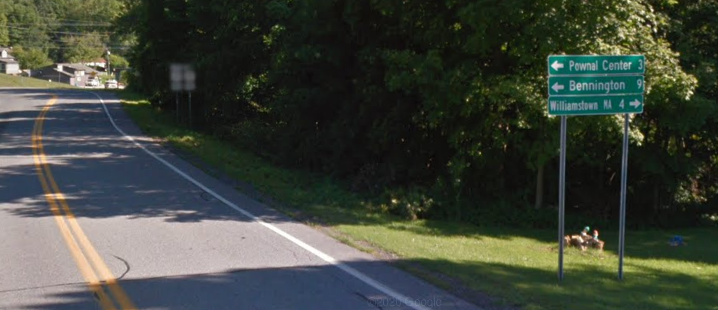
Details of the cities sign: | Details of the cities sign: | ||
[[File:W1qa-vt-346-cities.PNG|border]]<br /> | [[File:W1qa-vt-346-cities.PNG|border]] | ||
Route signs are located at the intersection, or in this case, slightly before the intersection: | |||
<br /> | |||
Revision as of 02:57, 28 June 2022
VT Surface Shields
In early 2022, Pete (whoaitspete) and I discussed adding surface street turn instructions with shields.
Vermont has a pretty good (and consistent) system whereby signs in advance of an intersection identify control cities and at the intersection signs identify the routes. This has been implemented on a few intersections in VT, as a way to gain editor insight in what needs to be done to properly add these in WME, as well as to see the results whilst navigating.
Let's review one that can be found at the intersection of VT-346 and US-7 in Pownal VT:
https://waze.com/en-US/editor?env=usa&lat=42.76350&lon=-73.23240&marker=true&zoomLevel=20&nodes=42316886

As you drive southeast on VT-346 you encounter the control cities sign approximately 450 feet from the intersection:
Details of the cities sign:

Route signs are located at the intersection, or in this case, slightly before the intersection: