mNo edit summary |
mNo edit summary |
||
| Line 5: | Line 5: | ||
__TOC__ | __TOC__ | ||
===When to add roads=== | |||
Cities in India have been growing rapidly, with lots of roads being made and connected to existing roads. If you notice any roads on the satellite layer that has not been added to the base map, please first confirm that they exist before adding them. Do not add any roads without either: | |||
* Clear GPS tracks following the aerial when the GPS Points layer is turned on. | |||
* Seeing the road in the Street View feature, where that's available. | |||
* Local knowledge, or confirmation by a local host. | |||
If you doubt an existing road is drivable, please don't delete them without prior discussion with the [[India Community|local area manager]] or one of the champs. And if you're extending an existing road, please ensure that you always verify that the road has been completed and properly connected before extending it. | |||
<br /> | |||
[[File:In New Roads.png|right|300px]] | |||
<br /> | |||
If you turn on the [[Waze_Map_Editor#Layer_Menu|GPS layer]], you can see if the road has been driven on. If the layer doesn’t show any GPS arrows, it’s possible that the road hasn’t been opened for the public, or is just a road that has not been driven on by a Wazer yet. <br /> | |||
<br /> | |||
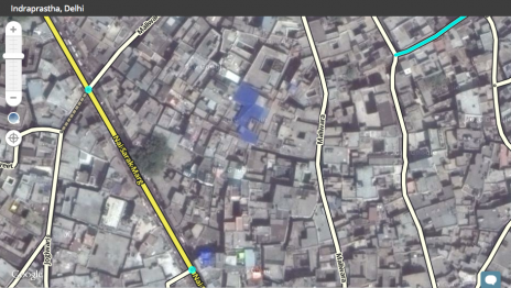
On the right side of the image, running alongside the Yamuna Expressway, there is a service lane that hasn’t been driven on. Leave it like this. If you live in the region, pay the location a visit to see if the road is open and drivable. <br /> | |||
<br /> | |||
How to add roads is described in the [[Quick start guide]].<br /> | |||
<br /> | |||
===Non-existent roads=== | |||
[[File:In New Roads.png|300px|left]]1. New Roads | |||
{{Clear}} | |||
[[File:In Non-existent road 1.png|300px]] 2a. Non-existent roads | |||
{{Clear}} | |||
[[File:In Non Existent Roads solution.png|300px]] 2b. Disconnecting a non-existent road | |||
{{Clear}} | |||
[[File:In Unfinished road.png|300px]] 3. Unfinished road | |||
{{Clear}} | |||
<br /> | |||
There may be roads that have been drawn in the base-map but may not be in the satellite images, or they may not exist in real life at all. Again, the GPS points will help you determine their status. If the satellite image shows an incomplete road with no GPS points (Pic 2), leave the road in the base map. If it’s already drawn, disconnect the junction nodes to valid roads (Pic 2b). If no road has been drawn (see Pic. 3), go ahead and add the road with the name “Road Under Construction”. Do not connect it to any other roads. The road can then be easily found and completed once the road is opened. | |||
<div style="text-align: right; direction: ltr; margin-left: 1em;"><small>[[#TOC|''go back to the table of content'']] or [[#TOP|''back to the top'']]</small></div> | |||
===Extremely Narrow Streets=== | |||
Many cities in India are extremely densely populated. Perhaps this is because they used to be villages that have been absorbed into one large city. Villages often have the same layout and structure. Many of the streets in these areas are too narrow to drive through, and shouldn’t be allowed for routing. You can turn off the [[Waze_Map_Editor#Layer_Menu|Roads layer]] to have a proper view on the Satellite Imagery. | |||
<gallery mode=packed-overlay heights=175px > | |||
File:Extremely Narrow Streets2.png|View with Roads layer on | |||
File:Extremely Narrow Streets1.png|View with Roads layer off | |||
</gallery> | |||
As the pictures show, the primary street at the left side of the picture is a proper drivable road. At the right side, the buildings are densely packed and the streets are too narrow to drive through with a car. <br /> | |||
<br /> | |||
If you see streets drawn over these areas, please turn the Roads layer off and verify if the roads are drivable or not based on the Satellite View. Also verify if there are no GPS tracks by turning on the GPS Points layer. <br /> | |||
<br /> | |||
If the verifications confirm these streets are not drivable, check the last update. If you see an editor listed there, contact him or her: probably there was a reason to keep the road. If there is no reason, delete them.<br /> | |||
<br /> | |||
Always use extreme caution before deleting segments. If you have any doubt, please discuss it with the Area Manager, or contact one of the local champs.<br /> | |||
<br /> | |||
===Naming rules=== | ===Naming rules=== | ||
Revision as of 12:35, 13 May 2018
New India Wiki is being built, For now, please see the pages about Waze in India in the old Wiki.
Roads
Without roads, no navigation. Drawing the available roads in our map and connect them well is our first concern.
When to add roads
Cities in India have been growing rapidly, with lots of roads being made and connected to existing roads. If you notice any roads on the satellite layer that has not been added to the base map, please first confirm that they exist before adding them. Do not add any roads without either:
- Clear GPS tracks following the aerial when the GPS Points layer is turned on.
- Seeing the road in the Street View feature, where that's available.
- Local knowledge, or confirmation by a local host.
If you doubt an existing road is drivable, please don't delete them without prior discussion with the local area manager or one of the champs. And if you're extending an existing road, please ensure that you always verify that the road has been completed and properly connected before extending it.

If you turn on the GPS layer, you can see if the road has been driven on. If the layer doesn’t show any GPS arrows, it’s possible that the road hasn’t been opened for the public, or is just a road that has not been driven on by a Wazer yet.
On the right side of the image, running alongside the Yamuna Expressway, there is a service lane that hasn’t been driven on. Leave it like this. If you live in the region, pay the location a visit to see if the road is open and drivable.
How to add roads is described in the Quick start guide.
Non-existent roads
1. New Roads
 2a. Non-existent roads
 2b. Disconnecting a non-existent road
 3. Unfinished road
There may be roads that have been drawn in the base-map but may not be in the satellite images, or they may not exist in real life at all. Again, the GPS points will help you determine their status. If the satellite image shows an incomplete road with no GPS points (Pic 2), leave the road in the base map. If it’s already drawn, disconnect the junction nodes to valid roads (Pic 2b). If no road has been drawn (see Pic. 3), go ahead and add the road with the name “Road Under Construction”. Do not connect it to any other roads. The road can then be easily found and completed once the road is opened.
Extremely Narrow Streets
Many cities in India are extremely densely populated. Perhaps this is because they used to be villages that have been absorbed into one large city. Villages often have the same layout and structure. Many of the streets in these areas are too narrow to drive through, and shouldn’t be allowed for routing. You can turn off the Roads layer to have a proper view on the Satellite Imagery.
-
View with Roads layer on
-
View with Roads layer off


As the pictures show, the primary street at the left side of the picture is a proper drivable road. At the right side, the buildings are densely packed and the streets are too narrow to drive through with a car.
If you see streets drawn over these areas, please turn the Roads layer off and verify if the roads are drivable or not based on the Satellite View. Also verify if there are no GPS tracks by turning on the GPS Points layer.
If the verifications confirm these streets are not drivable, check the last update. If you see an editor listed there, contact him or her: probably there was a reason to keep the road. If there is no reason, delete them.
Always use extreme caution before deleting segments. If you have any doubt, please discuss it with the Area Manager, or contact one of the local champs.
Naming rules

- Put the most important street identification in the primairy street name. Importance from high to low: Asian Highway, National Highway, State Highway, Major district road, named road (like Hosur rd or Bannerughatta rd).
- Put the lowest numbered road in the primary street name if there are more than one candidates for the primary street name. If for example the SH-20 and the SH-38 follow the same route, use the SH-20 as primary and SH-38 as alternative name.
- Put all other known street names and numbers in the alternative street names. Their order doesn't matter.
- Abbreviate the word Road to Rd, Highway to Hy. For others see the page on Standard road abbreviations.
- If no street name is known, check None.
- Use the same spelling for the same street name along the whole route.
- For bridges with well-known names the road segment crossing the bridge can have the name of the bridge as primary name, so the otherwise primary name goes to the alternative names. Another option is to add a well known bridge as point of interest.
Highways
Asian Highway Network
Seven Asian Highways are running across India.
AH1 Tokyo - India via Kolkata in West-Bengal - New Delhi - Attari in Punjab - Turkey; total length: 20,557 km
AH42 Lanzhou (China) - Barhi in Jharkhand. Length: 3,754 km
AH43 Agra in Uttar Pradesh - Matara (Sri Lanka). Length: 3,024 km
AH45 Kolkata - Bengaluru. Length: 2,030 km.
AH46 Hazirah in Gujarat - Howrah in West-Bengal. Length: 1,967 km. The Indian Great Eastern Highway.
AH47 Gwalior in Madhya Pradesh - Bengaluru in Karnataka. Length: 2,057 km.
AH48 Bhutan - West-Bengal. Length 90.58 km.
Street name notation: Use AH plus number (without a hyphen), like: AH1, AH42.
Road type: Freeway or Major Highway.
National Highways
In 2010 a new numbering system for the National Highway network was introduced. The new numbering system is based on the orientation (east-west and north-south) and the geographic location of the highway. Still for many highways the old highway number is used. The National Highways Authority of India (NHAI) is the national government agency that is responsible for the highways.
standard rule is keeping the old NH-number in the primary street name until user reports or pictures (road signs) give evidence that the new number is being used. The new number can be added as alternative street name. If the new highway name is really used the new NH-number should be used as primary street name and the old NH-number goes to the alternative name.
The government agency NHAI National Highway map.
Street name notation NH-# where # stands for the highway number, like NH-72.
Road type: Freeway or Major Highway.
State Highways
The individual states are responsible for their state highways.
Street name notation: SH-# where # stands for the state highway number, like SH-25.
Road type: Minor Highway
Major District Roads
Street name notation: MDR-# where # stands for the Major District Road number, like MDR-110.
Road type: Primary Street or Minor Highway.