Translations:Complex Restrictions/1/en Geschiedenis weergeven

(Created template)
 
(Importing a new version from external source)
 
(3 tussenliggende versies door 2 gebruikers niet weergegeven)
Regel 1: Regel 1:
Usage of any external copyrighted source of information, in order to add information to the Waze database or maps, is not allowed. External copyright information includes any online or printed map information that is not provided by Waze like Google Aerial imagery.  
==Complex Restrictions==
 
With a standard [[Restrictions|time based restriction]] a certain road can be closed for a certain period. It is also possible to define more restrictions on the same road, not only for different time slots but also per verhicle type (for instance motorcycle and taxi) or on minimum passengers.
Google's terms of use means that Waze cannot use their aerial images to update Waze maps. Those terms of use also apply to any user or editor of the Waze maps and database. Users cannot use Google's aerial images to edit the Waze maps. In some jurisdictions you may be able to use them as a reference (like looking at a map in a mapbook), but not as an overlay as with the Greasemonkey script Googze.
<br />
 
[[File:Private-road-nl3.jpg|right|150px]]
Using any source of external copyright information, such as Google Aerial imagery, puts the Waze maps under danger of being forced to revert all changes done to the map in your area / country.
In case a restriction is defined during a certain duration '''except for destination traffic''' a more complex solution is necessary.  
 
This type restriction described here is often used on the borders of a certain area to prevent traffic passing through. More than one complex restriction will be needed: they should be applied on all entrance roads to this area on the in-going traffic. Outward traffic should always be possible.
If any user were to do such a thing, it would taint all the work that person did on the maps and Waze would need to reverse out all those edits. There could also be other adverse effects. Waze has already had to remove all the maps for Chile, and other South American countries because the source of the map data was not properly licensed (not the result of any Waze action).
<br />
 
* Add the simple time based one way restriction on the existing road into the restricted area.
So do not use Googze as a way of applying Google's aerial images as a replacement for Waze's licensed images when doing map editing.
* Add two extra [[Private road|private road]] segments without restrictions as one way roads into the restricted area to accomodate the entrance of ''destination traffic''. Define these private roads with [[Elevation|elevation]] -1 or with an angle bigger than 3 degress to prevent the overlapping roads warning.  
 
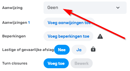
* Set the [[Junction Arrows|turn restrictions]] to prevent traffic from the time based restriction road towards the private road segments, vice versa.
Users may negotiate with officials in their country for access to aerial images that Waze can use. The user must be careful not to give the impression that they are acting on behalf of Waze. But as an interested citizen any user can speak with local authority, in a local language, to explain the benefits to their country in making aerial images freely available as a public good.
* Set [[Junction_Arrows#Turn_Instruction_Overrides|TIO]] voice prompts to None to suppress "keep left", "keep right" instructions while passing this construction. [[File:Tio-voice-prompt-none.png]]
 
* Lock the complete construction on '''L3''' or '''L4'''.
Note that external copyright information does not include any source of information that is provided by Waze through the internal tools of the online editor or application. Also any information developed independently by a user being physically present at a site is acceptable to add to the map as long as it is provided without copyright.
* And add a [[Map Comment|map comment]] with subject (gate/gateway) "sluisje"/"barrière" and a description of the complex restriction.<br />
<br />
[[File:Time-based-restriction-sluisje.png|500px]]

Huidige versie van 10 okt 2018 om 21:50

Informatie over bericht (bijdragen)
Dit bericht heeft geen documentatie. Als u weet waar of hoe dit bericht wordt gebruikt, dan kunt u andere gebruikers helpen door documentatie voor dit bericht toe te voegen.
Berichtdefinitie (Complex Restrictions)
==Complexe beperkingen==
Met een standaard [[Restrictions|tijdgebonden beperking]] kan een bepaalde weg voor een bepaalde periode worden afgesloten. Het is ook mogelijk om meer beperkingen op dezelfde weg te definiëren, niet alleen voor verschillende tijdvakken maar ook per voertuigtype (bijvoorbeeld motorfiets en taxi) of voor minimumpassagiers.
<br />
[[File:Private-road-nl3.jpg|right|150px]]
Indien een beperking gedurende een bepaalde tijdsduur '''behalve voor bestemmingsverkeer''' wordt gedefinieerd, is een uitgebreidere oplossing noodzakelijk.<br>
<br>
Deze hier beschreven typebeperking wordt vaak toegepast aan de grenzen van een bepaald gebied om doorstroming te voorkomen. Er zal meer dan één complexe beperking nodig zijn: ze moeten worden toegepast op alle toegangswegen naar dit gebied op het doorgaande verkeer. Uitgaand verkeer moet altijd mogelijk zijn.
<br />
* Voeg de eenvoudige op tijd gebaseerde eenrichtingsbeperking op de bestaande weg toe aan het beperkte gebied.
* Voeg twee extra [[Private road|privéweg]]-segmenten toe zonder beperkingen als eenrichtingswegen in het beperkte gebied om de ingang van ''bestemmingsverkeer'' te accommoderen. Definieer deze privé wegen met [[Elevation|hoogte]] -1 of met een hoek groter dan 3 graden om de waarschuwing voor overlappende wegen te voorkomen.
* Stel de [[Junction Arrows|afslagbeperkingen]] in om verkeer van de op tijd gebaseerde beperkingsweg naar de privéwegsegmenten te voorkomen, en vice versa.
* Stel [[Junction_Arrows#Turn_Instruction_Overrides|TIO]] gesproken prompts in op '''Geen''' om de instructies voor "links houden", "rechts houden" te onderdrukken bij het passeren van deze constructie. [[Bestand:Tio-voice-prompt-none.png]]
* Zet de complete constructie op '''L3''' of '''L4'''.
* En voeg een [[Map Comment|kaartopmerking]] toe met onderwerp (poort/poort) "sluisje"/"barrière" en een beschrijving van de complexe beperking.<br />
<br />
[[File:Time-based-restriction-sluisje.png|500px]]

Complex Restrictions

With a standard time based restriction a certain road can be closed for a certain period. It is also possible to define more restrictions on the same road, not only for different time slots but also per verhicle type (for instance motorcycle and taxi) or on minimum passengers.

In case a restriction is defined during a certain duration except for destination traffic a more complex solution is necessary. This type restriction described here is often used on the borders of a certain area to prevent traffic passing through. More than one complex restriction will be needed: they should be applied on all entrance roads to this area on the in-going traffic. Outward traffic should always be possible.

  • Add the simple time based one way restriction on the existing road into the restricted area.
  • Add two extra private road segments without restrictions as one way roads into the restricted area to accomodate the entrance of destination traffic. Define these private roads with elevation -1 or with an angle bigger than 3 degress to prevent the overlapping roads warning.
  • Set the turn restrictions to prevent traffic from the time based restriction road towards the private road segments, vice versa.
  • Set TIO voice prompts to None to suppress "keep left", "keep right" instructions while passing this construction.
  • Lock the complete construction on L3 or L4.
  • And add a map comment with subject (gate/gateway) "sluisje"/"barrière" and a description of the complex restriction.