Değişiklik özeti yok |
kDeğişiklik özeti yok |
||
| 44. satır: | 44. satır: | ||
== Raid Areas == | == Raid Areas == | ||
[[Dosya: | [[Dosya:Batman_zone.png|çerçeveli|orta]] | ||
There are 10 groups. The participants are listed in the [https://www.waze.com/forum/viewtopic.php?f=1392&t=240310&sid=143206170cbefeb4b2e982809dc44142#p1718667 forum]. Read more about Batman on the [http://www.batman.bel.tr/ website of the municipality]. | There are 10 groups. The participants are listed in the [https://www.waze.com/forum/viewtopic.php?f=1392&t=240310&sid=143206170cbefeb4b2e982809dc44142#p1718667 forum]. Read more about Batman on the [http://www.batman.bel.tr/ website of the municipality]. | ||
15.09, 17 Kasım 2017 tarihindeki hâli

| Start: October 15th (Sunday) 10:00 UTC | End: October 23rd (Monday) 22:00 UTC |
Goals In order of importance:
- Create new roads where there is no basemap [Primary Goal]
- Fix basemap roads (including moving the roads to the correct places and ensuring connectivity) [Secondary Goal]
- Update pending “Places”
- Solve User Reports and Map Problems
Hosts
Communication
We will use these two methods to communicate:
- Waze's official but limited chat within WME
- Waze Global Discord Server. Editors are already added in groups in the Waze Global Server for even better communication
- Primary communication language is English as we have editors from 43 different countries. Please ask for help if you need help with translation
- When working in the raid area, please set yourself visible in WME chat and turn on the Live Users layer
Raid Areas

There are 10 groups. The participants are listed in the forum. Read more about Batman on the website of the municipality.
We kindly urge you to stay within the raid area of Batman. Use the overlay script to help you know where you are. Note that the overlay is not very detailed at the border, so it is not a source for city names in that area.
| Zone 1 | Zone 6 |
| Zone 2 | Zone 7 |
| Zone 3 | Zone 8 |
| Zone 4 | Zone 9 |
| Zone 5 | Zone 10 |
MapRaid Guidance
Before you edit

In countries like the USA, France, and Germany, the following terms are commonly used to describe the rule of the road for these countries:
- Right-hand traffic (RHT) - Traffic position
- Keep to the right - Traffic position
- Drive on the right - Traffic position
- Left-hand drive (LHD) - Driver position
Turkey is a Right-Hand-Traffic (RHT) country. Read the section on this.
Also note: In WME, various settings must be adjusted in the left-hand editing panel before you edit.

1. The settings tab is the gear icon on the right.

2. Enable these preferences. Unlike in the USA, all segments must be created as two-way, although the direction can be edited as needed once it's on the map.

3. Check to make sure that the units are set to Metric, you are in World environment, and the correct language is selected.
Improve major connectivity

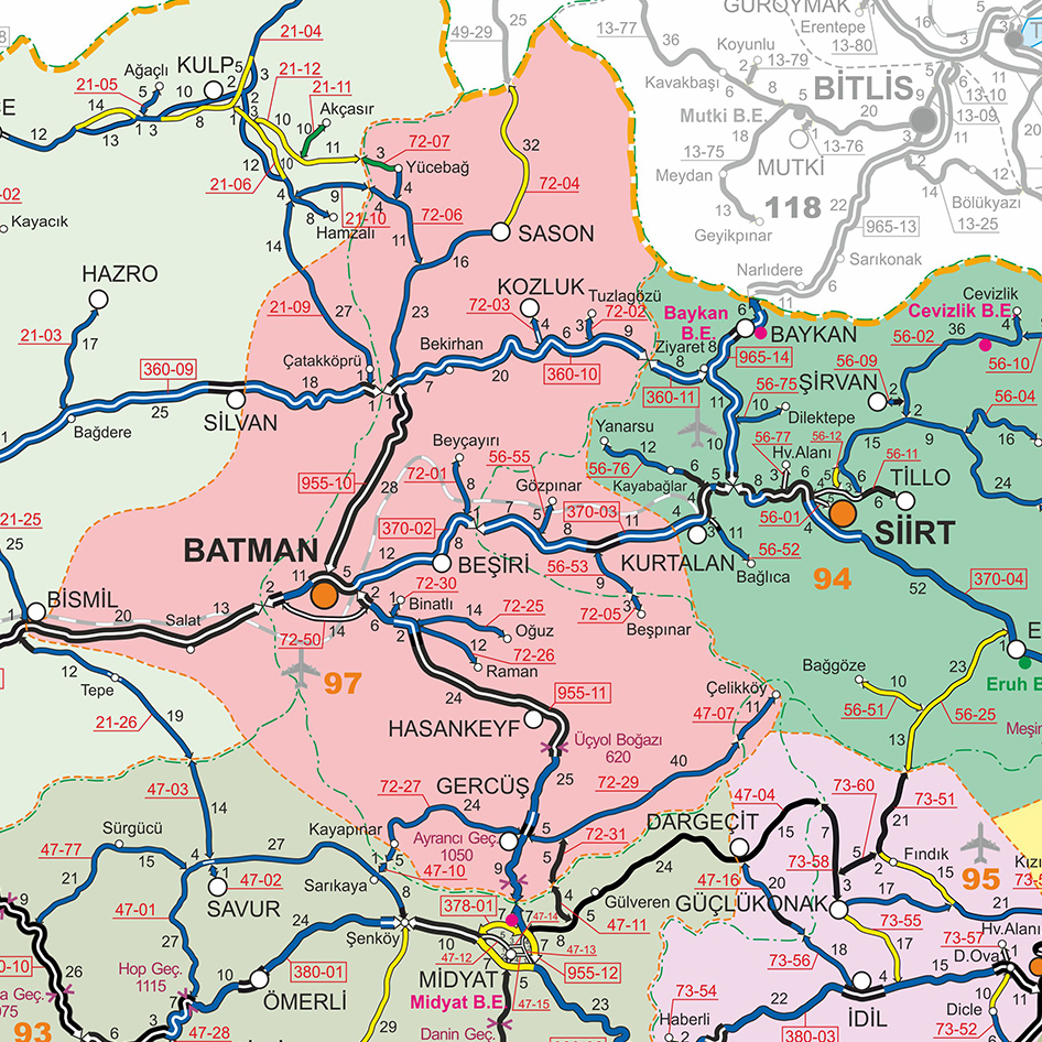
We need to check the routes that connect the neighborhoods. Many times, highways are interrupted by lower level streets, and Waze cannot calculate a long distance route. Like the example in the picture: because the roundabout is of road type Street, Waze will NOT use it in long distance routing. It should be corrected to road type MH. Moreover, this should not be a roundabout, like many roundabouts in Turkey.

You can check routes on the live map. Helpful is the information on road categories in the Turkish wiki page. The government provides an overview of the major roads for Batman, Click on the picture for a larger image.
Correcting base map
In many places, the base map needs to be corrected. Some segments were created from lines on the map that are other features and are not roads at all. You can read more about it in the paragraph on the Turkish wiki page.
Add missing roads
Please read the simple quick-start guide for a guideline on adding new roads. More information can be found on the Turkish wiki page. If you notice any roads on the satellite layer that have not been added to the WME map, please first confirm that they exist before adding them. Make sure the road is complete, drivable and is connected to the rest of the road network. Please use the government references in the tools section for confirmation — these are the most important connecting roads to add. Some other clues you can use to confirm smaller roads are:
- GPS layer showing Wazers are driving on the road.
- Street View and Satellite View on the road, showing it is in use
- Information from local drivers who have been there (this can be you if you have been there).
NOTE: If the road is classified as mH or higher and is wide enough for median segments at intersections to be >5m, you need to create two one-way segments. You can unset the checkbox for "Draw new roads as two-way" to help with this.
If an existing road is classified as mH or higher, it should be divided as long as it is wide enough. Median segments at intersections should be >5m. To divide an existing road, create two one-way segments from each 2-way segment (preserving the traffic data in both directions). If you are not familiar with the technique for preserving traffic data in both directions, please work with an editor who is.
Solve URs and MPs
When responding to URs, you have few choices. You can use Google Translate, ask in our MapRaid Discord channel, or use the following responses we have prepared for handling URs here.
Update Request Lifecycle
Turkey has adopted a 1/4/7 day schedule when responding to Update Requests.

Our goal is to respond to new URs within 24 hours. If the solution is obvious, fix the issue, leave a comment, and close out the report as "Solved". Otherwise, if there's ANY ambiguity to the problem, leave a comment asking for further clarification. This comment starts the UR response clock as Day 1.

If the reporter hasn't responded within 4 days of the initial comment, leave a reminder comment that additional information is required to resolve the report and it will be closed soon if there is no response. If the reporter replies with the required information, the issue is resolved, and the report is closed as appropriate. If further clarification is still required, the response clock starts over on Day 1 as the editor awaits new information.

If the reporter has not responded after 7 days from the initial editor comment, leave a comment letting the reporter know the UR is being closed, and save the report as "Not Identified". If you find a UR which is older than 7 days which has not been touched by another editor but requires additional information to resolve, apologize for the late response and ask if the reporter still remembers the problem and can clarify. This starts the UR response clock as Day 1.
Correcting road names
Batman has 6 districts. As the address administration changed in 2014, many roads are wrongly named. We are currently in contact with the municipality for the use of a GIS source. At least we need the districts added to the road name to be able to have unique addresses. This will be done in the city field as described on the Turkish wiki page.
Unfortunately, we cannot use the overlay to define the borders of the districts. Click on the picture above to see a larger version from the source.
We need to write a warning too, because road naming is very complex in Turkey: Do not copy, do not delete existing road names. Only update road names if you have verified them and are absolutely sure! We are currently writing a help file for this.

Abbreviations

When you edit road names, make sure also to use the correct abbreviations and Turkish letters.
We use the Turkish national standards for abbreviations of the roads, according to TDK. Most used abbreviations for WME are:
| Sokak | Sok |
| Cadde | Cad |
| Kavsak | Kvş |
| Mahalle | Mah |
| Bulvar | Blv |
| Yolu | Yolu |
| Çevreyolu | Çvy |
Speed Limits
NOTE: Adding Speed Limits is NOT a goal of this MapRaid. You may update speed limits ONLY after you verify them with Street View within Waze Map Editor, and only if the SV images are recent.
All Speed Limits in Turkey are in km/h (kph). The table only shows the default Speed Limit Rules, please extensively use the street view images to verify the speed limits.
| Road Type | Speed in km/h (kph) |
|---|---|
| Freeway | 120 |
| Rural road, double lane | 110 |
| Rural road, single two-way lane | 90 |
| Urban road | 50 |
(source: http://www.kgm.gov.tr/Sayfalar/KGM/SiteTr/Trafik/HizSinirlari.aspx)
For all edits, please read the Turkish wiki page for the specific guidance editing in Turkey!
Road Classification
| Road Type | Turkish Name | Description | Road Sign |
|---|---|---|---|
| Freeway | Otoyol | Otoyollar (O-XX) | Uluslararasi Yollar (E-XX)
Motorway | International Road |
|
| Major Highway | Devlet Yolu | Devlet Yollari / State Roads (D-XXX) | |
| Minor Highway | İl Yolu | Ïl Yollari / Provincial Road (XX-XX) | |
| Primary Street | Ana Cadde | Major Thoroughfares in Districts and Towns | |
| Street | Sokak | All local streets | |
| Ramp | Baglanti Yolu / Kavşak | Exit Number Sign ('K.XX - Kavşak) |
Locking Standard
We suggest you lock the roads near the end of MapRaid to ensure that junior editors can make the appropriate changes without overwhelming senior editors with unlock requests.
| Segment Type | Default locks |
|---|---|
| Freeway | 5 |
| Ramp | Highest rank of connected segment |
| Major Highway | 5 |
| Minor Highway | 4 |
| Primary Street | 3 |
| Street | 1(Auto) |
| |-|-|-|-|-|-|-|-|-| Railroad |-|-|-|-|-|-|-|-|-| | 2 |
| • • • • Ferry • • • • | 6 |
Road Type Zoom Levels

Mass edits and quality
In Base Map areas, mass edits are allowed, as long as they are constructive to the map. Be aware that we will monitor edits, so avoid unnecessary edits and hunting for points. Quality counts, not quantity. Sanctions are strict, being banned from this and future MapRaids. In addition, Waze throttles your edits and points when scripts are used excessively, meaning that you don't earn points for mass editing.
If you are using a tool or script, you are fully responsible for its use and its consequences. Please make sure that you understand the features of the script you are using. You will be held accountable for any side effects.
- If you are unsure about something, please ask.
- Check and triple check.
- We have great leaders here who can help you.
- Let's make sure we do it right the first time, and set a great example for the rest of the world.
Tools for this MapRaid
Editing Resources
Only use sources that are allowed by Waze.
Allowed sources:
- Satellite Imagery and Street View from within WME
- Websites from businesses
- Local, official government website - www.kgm.gov.tr
- A map of Batman from that site
- Roads and Road Traffic Act, with highways and major roads, and an Just the pages with the road names, courtesy of FaraonMartinez
NOT allowed sources:
- Information from other maps
- Google Maps
- Google Street View
Warning: If you copy information from unauthorized sources, you may be removed from this mapraid. Also, every segment you edited may be removed from the map. Copying information from copyrighted sources is illegal!
Basic reference links
- Simple Quick Start Guide
- How to make a Permalink
Specific tools for this MapRaid
- Use this https://greasyfork.org/en/scripts/34421-wme-mapraid-regions-zambia overlay for WME] to view the boundaries of Batman Region via an extra layer. Keep in mind that the border is very rough and cannot be used to define the city limit.
- To use the overlay, you must first have TamperMonkey (Chrome) or Greasemonkey (Firefox) installed.
Highly recommended tools
Many tools are essential for good editing, and others make the editing process much easier. Highly recommended are:
WME Toolbox
- This is a script that facilitates the process of editing maps in the WME. It has a toolbar that facilitates the process of removing unnecessary nodes, cut segments, locate "Soft Nodes", or nodes with undefined directions. (Note: it is currently not stable)
WMEMagic
- This is a plugin based framework to enhance editors so that they can be more productive
- Install for Chrome only (Requires Tampermonkey).
Junction Angle Info
- An extension that shows junction's angles. It is essential to set up proper navigation instructions.
WME URL Fixer
- Temporary workaround to get your userscripts working again when you are missing the trailing slash in the URL
- Install for Chrome (Requires Tampermonkey)
- Install for Firefox (Requires Greasemonkey)
Street View Availability
- A script that shows availability of the Street View imagery over the WME (segments and places).
- Install for Chrome (Requires Tampermonkey)
- Install for Firefox (Requires Greasemonkey)
Please remember that you are responsible for edits made through the use of scripts
Always understand what the script does before using it! There is a wiki page and a forum with more information.
Turkish Letters
There are some letters in the Turkish alphabet that might not be on your keyboard. You can copy and paste them from here
| UPPER | lower |
|---|---|
| Ç | ç |
| Ğ | ğ |
| I | ı |
| İ | i |
| Ö | ö |
| Ş | ş |
| Ü | ü |