(Yeni sayfa: "800x800px|çerçevesiz|orta <div style="border: 1px solid rgb(170, 170, 170); margin: 4px; padding: .25em 1em .25em 1em; border-collapse: collapse; back...") |
(Spanish Traslation) |
||
| 5. satır: | 5. satır: | ||
{| class="wikitable center" | {| class="wikitable center" | ||
|<span style="color:green">''' | |<span style="color:green">'''Inicio: Noviembre 20 (Lunes) 10:00 UTC'''</span> | ||
|<span style="color:red">''' | |<span style="color:red">'''Fin: Noviembre 30 (Jueves) 22:00 UTC'''</span> | ||
|} | |} | ||
| 12. satır: | 12. satır: | ||
__TOC__ | __TOC__ | ||
== | == Objetivos en orden de importancia: == | ||
# | # Crear nuevas carreteras donde no hay un mapa base <span style="color:red">'''[Objetivo Primario]'''</span> | ||
# | # Reparar las rutas del mapa base (lo que incluye mover las carreteras a los lugares correctos y garantizar la conectividad) <span style="color:red">'''[Objetivo Secundario]'''</span> | ||
# | # "Lugares" pendientes por aprobar | ||
# | # Resolver reportes de usuarios (URs) y Problemas del Mapa (MPs) | ||
== | == Anfitriones == | ||
{| class="wikitable" | {| class="wikitable" | ||
|- | |- | ||
! EdItor !! | ! EdItor !! Rango !! Rol | ||
|- | |- | ||
| {{Username|OrbitC}} || 6 || MapRaid | | {{Username|OrbitC}} || 6 || Coordinador MapRaid | ||
|- | |- | ||
| {{Username|mapdevil}} || 4 || Area manager | | {{Username|mapdevil}} || 4 || Area manager | ||
| 33. satır: | 33. satır: | ||
|} | |} | ||
== | == Comunicación == | ||
Usaremos los siguientes canales de comunicación: | |||
* '''Waze | * El '''chat oficial de Waze '''dentro del WME | ||
* '''[https://discord.gg/YEtgvCN | * '''[https://discord.gg/YEtgvCN Servidor de Discord]'''. Los editores ya están agregados en grupos en el servidor Waze Global para una mejor comunicación | ||
* | * El lenguaje oficial de comunicación será Ingles ya que tenemos editores de 43 países diferentes. Solicite ayuda si necesita ayuda con la traducción | ||
* | * Cuando esté trabajando en el area del MapRaid, '''Por favor [[global:Waze_Map_Editor/Chat#Visible.2FInvisible|hazte visible]] en el chat del WME '''y acvtiva la capa''' [[global:Map_Editor_Interface_and_Controls#Live_Users|Live Users]] ''' | ||
== Raid | == Áreas del Raid == | ||
[[Dosya:Batman_zone.png|thumb|640px]] | [[Dosya:Batman_zone.png|thumb|640px]] | ||
Hay 4 grupos. Los participantes se enumeran en el [https://www.waze.com/forum/viewtopic.php?f=1392&t=240310&sid=143206170cbefeb4b2e982809dc44142#p1718667 foro]. Lea mas acerca de Batman en esta [http://www.batman.bel.tr/ página web]. | |||
Por favor mantener sus ediciones dentro del area asignada. Use la script [https://greasyfork.org/en/scripts/35404-wme-mapraid-regions-mapraid-x overlay] para ayudarte a saber donde te encuentras. Tenga en cuenta que la superposición no es muy detallada en el borde, por lo que no es una fuente de nombres de ciudades en esa área. | |||
{| class="wikitable center" | {| class="wikitable center" | ||
|[https://www.waze.com/editor?env=row&lon=41.19087&lat=38.07647&zoom=0 | |[https://www.waze.com/editor?env=row&lon=41.19087&lat=38.07647&zoom=0 Zona 1] | ||
|[https://www.waze.com/editor?env=row&lon=41.15825&lat=37.77234&zoom=0 | |[https://www.waze.com/editor?env=row&lon=41.15825&lat=37.77234&zoom=0 Zona 3] | ||
|- | |- | ||
|[https://www.waze.com/editor?env=row&lon=41.16409&lat=37.89490&zoom=0 | |[https://www.waze.com/editor?env=row&lon=41.16409&lat=37.89490&zoom=0 Zona 2] | ||
|[https://www.waze.com/editor?env=row&lon=41.13044&lat=37.55982&zoom=0 | |[https://www.waze.com/editor?env=row&lon=41.13044&lat=37.55982&zoom=0 Zona 4] | ||
|} | |} | ||
| 64. satır: | 66. satır: | ||
}} | }} | ||
--> | --> | ||
==Grupos del MapRaid== | |||
==MapRaid | |||
<div style="width: 35%; height: 55em; overflow: auto; border: 2px solid Blue;"> | <div style="width: 35%; height: 55em; overflow: auto; border: 2px solid Blue;"> | ||
{| class="wikitable sortable" | {| class="wikitable sortable" | ||
| 323. satır: | 324. satır: | ||
</div> | </div> | ||
==MapRaid | ==Guía para este MapRaid== | ||
==== | ====Antes de editar==== | ||
[[File:RHT.png|border|thumb|right|340px|Right-hand Traffic (RHT)]] | [[File:RHT.png|border|thumb|right|340px|Right-hand Traffic (RHT)]] | ||
En paises como '''Estados Unidos''', '''Francia''', y '''Alemania''', los siguientes términos se usan comúnmente para describir las normas de la carretera para estos países: | |||
* | * Left-hand traffic (LHT) - Posición de trafico | ||
* | * Manténgase a la derecha - Posición de trafico | ||
* | * Conduzca a la derecha - Posición de trafico | ||
* | * Conducción por la izquierda (RHT) - Posición del conductor | ||
Turquía es un país que conduce por la derecha ('''R'''ight-'''H'''and-'''T'''raffic '''(RHT))''' . Para leer mas al respecto ingrese [[global:Rule_of_the_road|aquí]]. | |||
{{clear}} | {{clear}} | ||
| 345. satır: | 346. satır: | ||
--> | --> | ||
''' | '''Para tener en cuenta: en el WME, Se deben ajustar varias configuraciones en el panel de edición de la izquierda antes de editar.''' | ||
[[Image:NewSettingsTABS.png|border|right]] 1. | [[Image:NewSettingsTABS.png|border|right]] 1. La pestaña de configuración es el icono de ajustes que encuentras a la derecha. {{clear}} | ||
[[Image:NewSettingsADVANCED.png |border|right]] 2. | [[Image:NewSettingsADVANCED.png |border|right]] 2. Habilita estas preferencias A diferencia de EE. UU., Todos los segmentos se deben crear como bidireccionales, aunque la dirección se puede editar según sea necesario una vez que esté en el mapa. {{clear}} | ||
[[Image:NewSettingsOTHER.png|border|right]] 3. | [[Image:NewSettingsOTHER.png|border|right]] 3. Verifique que las unidades estén configuradas en Métrico, se encuentre en el entorno Mundial y se haya seleccionado el idioma correcto. {{clear}} | ||
==== | ====Mejora la conectividad en vías principales==== | ||
[[File:Tr connectivity.PNG|thumbnail|right|<span style="color:#FF0000">needs to be corrected</span>]] | [[File:Tr connectivity.PNG|thumbnail|right|<span style="color:#FF0000">needs to be corrected</span>]] | ||
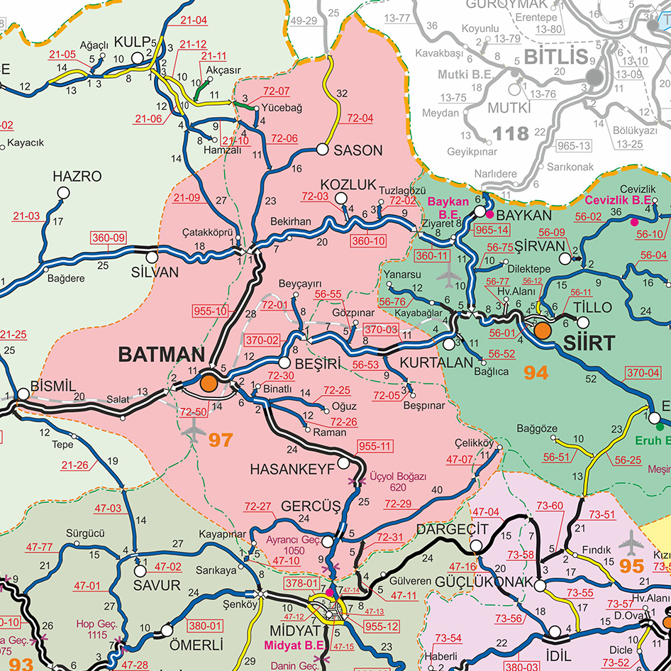
==== | Necesitamos verificar las rutas que conectan los vecindarios. Muchas veces, las calles de menor nivel interrumpen las carreteras y Waze no puede calcular una ruta de larga distancia. Como en el ejemplo de la imagen: debido a que la rotonda es de tipo calle, Waze NO la usará en el enrutamiento de larga distancia. Debe ser corregido a la carretera tipo MH. Además, esto no debería ser una rotonda, como muchas [[Ana_Sayfa#Roundabouts|rotondas en Turquía]].[[File:Batman roads.jpg|thumbnail|right|Major Roads of Batman]] | ||
Puedes verificar las rutas en el mapa en vivo. Te será muy útil la información sobre las categorías de carreteras en la [[Ana_Sayfa#Road_categories|wiki de Turquía]]. El gobierno proporciona una visión general de las [http://www.kgm.gov.tr/SiteCollectionImages/KGMimages/Bolgeler/9Bolge/Subeler/Batman.jpg carreteras principales de Batman], aga clic en la imagen para ampliarla. | |||
====Corrige el mapa ==== | |||
En muchos lugares, el mapa debe ser corregido. Algunos segmentos se crearon a partir de líneas en el mapa que tienen otras características y no son carreteras en realidad. Puedes leer más sobre esto en la [[Ana_Sayfa#Base Map Editing|wiki de Turquía]]. | |||
====Agrega carreteras faltantes==== | |||
Por favor lea la [[global:Map_Editing_Quick-start_Guide#Creating_a_road|Guía Rápida]] de como agregar nuevas carreteras. More information can be found on the [[Ana_Sayfa#How_to_start|Turkish wiki page]]. | |||
If you notice any roads on the satellite layer that have not been added to the WME map, please first confirm that they exist before adding them. | If you notice any roads on the satellite layer that have not been added to the WME map, please first confirm that they exist before adding them. | ||
Make sure the road is complete, '''drivable''' and is connected to the rest of the road network. Please use the government references in the tools section for confirmation — these are the most important connecting roads to add. | Make sure the road is complete, '''drivable''' and is connected to the rest of the road network. Please use the government references in the tools section for confirmation — these are the most important connecting roads to add. | ||
05.35, 21 Kasım 2017 tarihindeki hâli

| Inicio: Noviembre 20 (Lunes) 10:00 UTC | Fin: Noviembre 30 (Jueves) 22:00 UTC |
Objetivos en orden de importancia:
- Crear nuevas carreteras donde no hay un mapa base [Objetivo Primario]
- Reparar las rutas del mapa base (lo que incluye mover las carreteras a los lugares correctos y garantizar la conectividad) [Objetivo Secundario]
- "Lugares" pendientes por aprobar
- Resolver reportes de usuarios (URs) y Problemas del Mapa (MPs)
Anfitriones
Comunicación
Usaremos los siguientes canales de comunicación:
- El chat oficial de Waze dentro del WME
- Servidor de Discord. Los editores ya están agregados en grupos en el servidor Waze Global para una mejor comunicación
- El lenguaje oficial de comunicación será Ingles ya que tenemos editores de 43 países diferentes. Solicite ayuda si necesita ayuda con la traducción
- Cuando esté trabajando en el area del MapRaid, Por favor hazte visible en el chat del WME y acvtiva la capa Live Users
Áreas del Raid

Hay 4 grupos. Los participantes se enumeran en el foro. Lea mas acerca de Batman en esta página web.
Por favor mantener sus ediciones dentro del area asignada. Use la script overlay para ayudarte a saber donde te encuentras. Tenga en cuenta que la superposición no es muy detallada en el borde, por lo que no es una fuente de nombres de ciudades en esa área.
| Zona 1 | Zona 3 |
| Zona 2 | Zona 4 |
Grupos del MapRaid
Guía para este MapRaid
Antes de editar

En paises como Estados Unidos, Francia, y Alemania, los siguientes términos se usan comúnmente para describir las normas de la carretera para estos países:
- Left-hand traffic (LHT) - Posición de trafico
- Manténgase a la derecha - Posición de trafico
- Conduzca a la derecha - Posición de trafico
- Conducción por la izquierda (RHT) - Posición del conductor
Turquía es un país que conduce por la derecha (Right-Hand-Traffic (RHT)) . Para leer mas al respecto ingrese aquí.
Para tener en cuenta: en el WME, Se deben ajustar varias configuraciones en el panel de edición de la izquierda antes de editar.

1. La pestaña de configuración es el icono de ajustes que encuentras a la derecha.

2. Habilita estas preferencias A diferencia de EE. UU., Todos los segmentos se deben crear como bidireccionales, aunque la dirección se puede editar según sea necesario una vez que esté en el mapa.

3. Verifique que las unidades estén configuradas en Métrico, se encuentre en el entorno Mundial y se haya seleccionado el idioma correcto.
Mejora la conectividad en vías principales

Necesitamos verificar las rutas que conectan los vecindarios. Muchas veces, las calles de menor nivel interrumpen las carreteras y Waze no puede calcular una ruta de larga distancia. Como en el ejemplo de la imagen: debido a que la rotonda es de tipo calle, Waze NO la usará en el enrutamiento de larga distancia. Debe ser corregido a la carretera tipo MH. Además, esto no debería ser una rotonda, como muchas rotondas en Turquía.

Puedes verificar las rutas en el mapa en vivo. Te será muy útil la información sobre las categorías de carreteras en la wiki de Turquía. El gobierno proporciona una visión general de las carreteras principales de Batman, aga clic en la imagen para ampliarla.
Corrige el mapa
En muchos lugares, el mapa debe ser corregido. Algunos segmentos se crearon a partir de líneas en el mapa que tienen otras características y no son carreteras en realidad. Puedes leer más sobre esto en la wiki de Turquía.
Agrega carreteras faltantes
Por favor lea la Guía Rápida de como agregar nuevas carreteras. More information can be found on the Turkish wiki page. If you notice any roads on the satellite layer that have not been added to the WME map, please first confirm that they exist before adding them. Make sure the road is complete, drivable and is connected to the rest of the road network. Please use the government references in the tools section for confirmation — these are the most important connecting roads to add. Some other clues you can use to confirm smaller roads are:
- GPS layer showing Wazers are driving on the road.
- Street View and Satellite View on the road, showing it is in use
- Information from local drivers who have been there (this can be you if you have been there).
NOTE: If the road is classified as mH or higher and is wide enough for median segments at intersections to be >5m, you need to create two one-way segments. You can unset the checkbox for "Draw new roads as two-way" to help with this.
If an existing road is classified as mH or higher, it should be divided as long as it is wide enough. Median segments at intersections should be >5m. To divide an existing road, create two one-way segments from each 2-way segment (preserving the traffic data in both directions). If you are not familiar with the technique for preserving traffic data in both directions, please work with an editor who is.
Solve URs and MPs
When responding to URs, you have few choices. You can use Google Translate, ask in our MapRaid Discord channel, or use the following responses we have prepared for handling URs here.
Update Request Lifecycle
Turkey has adopted a 1/4/7 day schedule when responding to Update Requests.

Our goal is to respond to new URs within 24 hours. If the solution is obvious, fix the issue, leave a comment, and close out the report as "Solved". Otherwise, if there's ANY ambiguity to the problem, leave a comment asking for further clarification. This comment starts the UR response clock as Day 1.

If the reporter hasn't responded within 4 days of the initial comment, leave a reminder comment that additional information is required to resolve the report and it will be closed soon if there is no response. If the reporter replies with the required information, the issue is resolved, and the report is closed as appropriate. If further clarification is still required, the response clock starts over on Day 1 as the editor awaits new information.

If the reporter has not responded after 7 days from the initial editor comment, leave a comment letting the reporter know the UR is being closed, and save the report as "Not Identified". If you find a UR which is older than 7 days which has not been touched by another editor but requires additional information to resolve, apologize for the late response and ask if the reporter still remembers the problem and can clarify. This starts the UR response clock as Day 1.
Correcting road names
Batman has 6 districts. As the address administration changed in 2014, many roads are wrongly named. We are currently in contact with the municipality for the use of a GIS source. At least we need the districts added to the road name to be able to have unique addresses. This will be done in the city field as described on the Turkish wiki page.
Unfortunately, we cannot use the overlay to define the borders of the districts. Click on the picture above to see a larger version from the source.
We need to write a warning too, because road naming is very complex in Turkey: Do not copy, do not delete existing road names. Only update road names if you have verified them and are absolutely sure! We are currently writing a help file for this.

Abbreviations

When you edit road names, make sure also to use the correct abbreviations and Turkish letters.
We use the Turkish national standards for abbreviations of the roads, according to TDK. Most used abbreviations for WME are:
| Sokak | Sok |
| Cadde | Cad |
| Kavsak | Kvş |
| Mahalle | Mah |
| Bulvar | Blv |
| Yolu | Yolu |
| Çevreyolu | Çvy |
Speed Limits
NOTE: Adding Speed Limits is NOT a goal of this MapRaid. You may update speed limits ONLY after you verify them with Street View within Waze Map Editor, and only if the SV images are recent.
All Speed Limits in Turkey are in km/h (kph). The table only shows the default Speed Limit Rules, please extensively use the street view images to verify the speed limits.
| Road Type | Speed in km/h (kph) |
|---|---|
| Freeway | 120 |
| Rural road, double lane | 110 |
| Rural road, single two-way lane | 90 |
| Urban road | 50 |
(source: http://www.kgm.gov.tr/Sayfalar/KGM/SiteTr/Trafik/HizSinirlari.aspx)
For all edits, please read the Turkish wiki page for the specific guidance editing in Turkey!
Road Classification
| Road Type | Turkish Name | Description | Road Sign |
|---|---|---|---|
| Freeway | Otoyol | Otoyollar (O-XX) | Uluslararasi Yollar (E-XX)
Motorway | International Road |
|
| Major Highway | Devlet Yolu | Devlet Yollari / State Roads (D-XXX) | |
| Minor Highway | İl Yolu | Ïl Yollari / Provincial Road (XX-XX) | |
| Primary Street | Ana Cadde | Major Thoroughfares in Districts and Towns | |
| Street | Sokak | All local streets | |
| Ramp | Baglanti Yolu / Kavşak | Exit Number Sign ('K.XX - Kavşak) |
Locking Standard
We suggest you lock the roads near the end of MapRaid to ensure that junior editors can make the appropriate changes without overwhelming senior editors with unlock requests.
| Segment Type | Default locks |
|---|---|
| Freeway | 5 |
| Ramp | Highest rank of connected segment |
| Major Highway | 5 |
| Minor Highway | 4 |
| Primary Street | 3 |
| Street | 1(Auto) |
| |-|-|-|-|-|-|-|-|-| Railroad |-|-|-|-|-|-|-|-|-| | 2 |
| • • • • Ferry • • • • | 6 |
Road Type Zoom Levels

Unsurfaced Roads

DO NOT use the road type "Offroad / 4x4". Use the most appropriate road type for routing.
Do NOT use the unpaved checkbox for road types Primary Street and up. Only use the unpaved checkbox for segments of type "Street". Here is an example of a major highway which is not surfaced, but is not marked unpaved. This is to allow good routing.
Only add streets which motorized vehicles can use. Do not add roads which are not passable, not wide enough, etc.
Mass edits and quality
In Base Map areas, mass edits are allowed, as long as they are constructive to the map. Be aware that we will monitor edits, so avoid unnecessary edits and hunting for points. Quality counts, not quantity. Sanctions are strict, being banned from this and future MapRaids. In addition, Waze throttles your edits and points when scripts are used excessively, meaning that you don't earn points for mass editing.
If you are using a tool or script, you are fully responsible for its use and its consequences. Please make sure that you understand the features of the script you are using. You will be held accountable for any side effects.
- If you are unsure about something, please ask.
- Check and triple check.
- We have great leaders here who can help you.
- Let's make sure we do it right the first time, and set a great example for the rest of the world.
Turkish Letters
There are some letters in the Turkish alphabet that might not be on your keyboard. You can copy and paste them from here
| UPPER | lower |
|---|---|
| Ç | ç |
| Ğ | ğ |
| I | ı |
| İ | i |
| Ö | ö |
| Ş | ş |
| Ü | ü |
Tools for this MapRaid
Editing Resources
Only use sources that are allowed by Waze.
Allowed sources:
- Satellite Imagery and Street View from within WME
- Websites from businesses
- Local, official government website - www.kgm.gov.tr
- A map of Batman from that site
NOT allowed sources:
- Information from other maps
- Google Maps
- Google Street View
Warning: If you copy information from unauthorized sources, you may be removed from this mapraid. Also, every segment you edited may be removed from the map. Copying information from copyrighted sources is illegal!
Basic reference links
- Simple Quick Start Guide
- How to make a Permalink
Specific tools for this MapRaid
- Use this overlay for WME to view the boundaries of Batman Region via an extra layer. Keep in mind that the border is very rough and cannot be used to define the city limit.
- To use the overlay, you must first have TamperMonkey (Chrome) or Greasemonkey (Firefox) installed.
Highly recommended scripts
These tools are all scripts that will help you make better use of the information available to you in WME. For this mapraid, the following are highly recommended. You are responsible for learning what they do and using them appropriately.
- Tampermonkey plugin that will help you spot basemap problems more quickly. Ask group leaders for best basemap settings.
- Install for Chrome only (Requires Tampermonkey).
- An extension that removes the layer settings and insert the "missing" / in URLs
- Helps you spot 2-segment loops, segments with undefined direction, and "soft nodes" with unconfirmed turns, and has other tools available for higher-ranked editors. Some tools are not working following recent WME changes.
- An extension that shows junction's angles. Essential for knowing what the default Waze turn instructions will be.
- A script that shows where Street View imagery is available on WME segments and places.
- Install for Chrome (Requires Tampermonkey)
- Install for Firefox (Requires Greasemonkey)
Please remember that you are responsible for edits made through the use of scripts.
Always understand what the script does before using it! There is a wiki page and a forum with more information.
How To

Warning: A technical difficulty in WME is currently causing problems creating junctions in a couple of situations. When you try to junction a new, unsaved segment to a previously-saved segment, it may not save correctly. After you save, check that the two segments are junctioned by looking for arrows. To correct the problem, pull the end of one segment away, drop it, then pull it back to the junction point and drop it to create a junction. Save and check again. The script WME Magic can help you spot these errors on the map.
- Simple Quick Start Guide
- How to make a Permalink
- Introduction to editing