This revision of a section is currently undergoing modifications. The information presented should be considered a draft, not yet ready for use. This content is open to changes from anyone during construction. If you would like to make changes or have questions, please send a private message to this user.
Wayfinders
A wayfinder gives a user an instruction directing them how to continue on the road the user is already on, in situations where it may be unclear, and there would otherwise be no instruction.
Terminology
A travel lane is a lane which is long enough that a naïve driver might consider it a long-distance lane. For our purposes we will clarify this as any lane which;
before nearing the exit, is neither striped nor signed as a departing lane over a significant length (approximately ¾ a mile, or its full length, whichever is shorter), and
has not just started within a mile before the exit.
The typical side for an exit depends on the traffic side for that country. In a country with Right-hand traffic i.e. the USA, the typical side for an exit is the right side.
The atypical side for an exit is the opposite of the typical side described above.
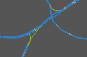
A continuation path or continuation is the group of lanes after the split which continue to be the same road as it was before the split. (In the following example, the lanes which continue to be I-47)
Criteria
A wayfinder is warranted in the following cases:
The continuation path on a controlled-access highway or freeway, when an exit is present on the typical side, has at least two fewer travel lanes after the exit than before it;
The continuation path on a controlled-access highway or freeway has the same amount or fewer lanes as the exit path after the split;
The continuation path on an uncontrolled highway, or when an exit is present on the atypical side, has at least one fewer travel lanes after the exit than before it;
The continuation path consists of a single lane; or
Other conditions exist that may suggest a split rather than an exit (use your better judgement, and discretion) -- for example:
The physical roadway itself forks or diverges with no clear straight-ahead direction;
The road which appears to be straight ahead is not the actual continuation;
Signage and striping do not clearly provide all expected "exit" indications, or do so inconsistently; or
Signs are present with arrows pointing left and right but no sign clearly establishes the continuation.
The original text of the wayfinder criteria to be replaced
A wayfinder gives a user an instruction reminding them to stay on the road the user is already on, in situations where a reminder is warranted. A wayfinder is warranted in the following situations:
Lane drops, where at least as many lanes leave the road as stay on the road;
Non-obvious continuations, where at least one "exit only" lane exists on the side of the road where exits are not normally placed (in a right-hand traffic country, exiting traffic is to the left and continuing traffic is to the right); and
Inconsistent signage, where a highway continues as a numbered route, but signs call it only by a name.
Need sample images for "lane drops" and "non-obvious continuations"; also, example of BGS with lane arrows
In these cases, we need to use a wayfinder configuration. Each wayfinder configuration will have one "IN" segment and two "OUT" segments.
Each "stub" segment should be 19.69 ft (6 m) long. This is long enough so it will not cause routing problems, but it is short enough to suppress display of the names (on Freeway stubs) and keep freeways looking contiguous (on Ramp stubs).
The OUT segments should have a turn angle of 10°-20° off of the mid-line on opposite sides of each other, consistent with the geometry for freeway splits. This will allow for easy identification in WME, but still look seamless in the client app.
To configure the wayfinder,
If the numbered/signed exit is on the right, the OUT segments should be Ramp type. This will give an "exit right" instruction for the exit and a "stay to the left" instruction for the continuation.
For a basic exit, use a named Ramp stub for the continuation, and a standard Ramp for the exit.
If the numbered/signed exit is on the left, the OUT segments type should be the same as the IN segment , in the following examples we will use the Freeway type. This will give "stay to the" instructions on both sides (if Ramp segments were used, Waze would give a confusing "exit right" instruction for the continuation).
For a basic exit, use a named Freeway stub for the continuation, and an unnamed Freeway stub followed by a named Ramp for the exit.
For a freeway split, use named Freeway stubs on both sides.
Exit direction
Type
Left OUT configuration
Right OUT configuration
Example
Right
Basic exit
Continuation side Named Ramp stub → Named Fwy
Exit side Named Ramp
Right
Fwy split
Continuation side Named Ramp stub → Named Fwy
Exit side Named Ramp stub → Named Fwy
Left
Basic exit
Exit side Unnamed Fwy stub → Named Ramp
Continuation side Named Fwy stub → Named Fwy
Left
Fwy split
Exit side Named Fwy stub → Named Fwy
Continuation side Named Fwy stub → Named Fwy
Segment naming
Keep these basic principles in mind:
The OUT segments must both be the same type (either Freeway , Major Highway , Minor Highway , or Ramp , as explained below).
Each OUT segment must have a name different than the IN segment.
NOTE: An unnamed segment (no-name box checked) is considered to have a blank name, and not the inherited name for these purposes. Therefore either both OUTs must be no-name, or both must have their own unique name.
OUT segments should be named with the information displayed on the roadway signs.
However, if this would leave an OUT segment with the same name as the IN segment, the OUT segment should be left unnamed (i.e., check the "no name" box).
Previously in these situations segment naming was modified in one of the following ways in order of preference:
Add a control/destination city, if it is known, to the OUT segment name.
Remove the compass cardinal from the OUT segment name.
Add a space to the end of the OUT segment name (note that this will be flagged by the WME Validator script, if active, and possibly result in undoing by another editor)
Create a stub in the IN segment just before the junction with no street name.
NOTE: This option should only be used as a last resort because it prevents the routing server from properly calculating turn delays, and may result in inefficient routing through the area.
If you see any of these set-ups, please correct it to one of the two the proper methods listed above.
If the continuation is signed, and a wayfinder is warranted,
If the continuation sign contains the name or shield of the continuing road, do not use "to" at the beginning of the name of the OUT segment. e.g., a freeway split where one side is the continuation of the same freeway (the user is already on the road, not going "to" it). Most wayfinders will fit this criterion.
If the name of the continuation is included but is not listed first on the sign, move the name of the continuing road to the beginning of the segment name. (e.g. In this wayfinder the highway you are on now, and continuing on is I-275, so the segment name should be "I-275 N / I-74 E / US-52 E / Cincinnati".)
If the continuation sign does not contain the name or shield of the continuing road, then the road name should begin with "to".
If the word "TO" is explicitly included on the continuation sign,
Move the shields or names affected by the "TO" to the end of the segment name after a slash (/). (The example BGS shown is for the continuation of I-80, which leads to I-280, with a control city Morristown.)
If any included control cities or road names correlate only to the roads affected by the "TO", then those control cities or road names should be moved after the "/ to [road(s)] /" on the segment name.
If Morristown is served by I-80, the continuation segment should be named "I-80 / Morristown / to I-280".
If any included control cities or road names correlate to the roads not affected by the "TO", then those control cities or road names should remain in place before "/ to [road(s)]".
If Morristown is served by I-280 and not by I-80, the continuation segment should be "I-80 / to I-280 / Morristown".
If the continuation is not signed, and a wayfinder is warranted,
If the OUT segment is a continuation of the same road, it should be left unnamed (check the "no name" box).
If the OUT segment is an exit, it should be named following the guidelines for an unsigned exit.
If the OUT segment is a short continuation of the same road leading to another road, name the segment starting with "to" followed by the name of the road to which the continuation leads, following these guidelines:
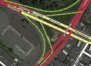
Where the wayfinder is just before, but not at, the termination of a road, so the continuation OUT segment is named for the road that the continuation leads to at the termination. However you still must travel for a short distance on the continuation of this road until those exits/termination. Our example here is a wayfinder on US-1-9 N (Truck), the left OUT is the continuation, however the right OUT also continues on the same road until it intersects with SR-440, with an exit to SR-440 S along this short segment. There are no roadway signs for any of these splits, or exits/terminations. The OUT segment here would be named "to SR-440 S / Communipaw Ave", and the SR-440 exit will be named following the unsigned exit guidelines. However it may be appropriate (if there are no House Numbers, or other on ramps past this wayfinder before it reaches the exit, to leave this entire portion with no-name, and the instruction will inherit the name of the next road you are going to.