U-Turns
The Waze Map Editor allows the enabling or restricting of U-turns using the green or red u-turn icons. U-Turns are legal in maryland with the following restrictions:
MD Transportation Code § 21-402(b) Vehicle turning left or making U-turn
(b) U-turn. -- If the driver of a vehicle intends to turn to go in the opposite direction, the driver shall yield the right-of-way to any approaching vehicle that is so near as to be an immediate danger.
MD Transportation Code § 21-602 U-turn on curve or crest of grade prohibited
(a) Curves. -- The driver of a vehicle on any curve may not turn to go in the opposite direction if the vehicle cannot be seen by the driver of any other vehicle that is within 500 feet and approaching from either direction.
(b) Crests. -- The driver of a vehicle on or approaching the crest of any grade may not turn to go in the opposite direction if the vehicle cannot be seen by the driver of any other vehicle that is within 500 feet and approaching from either direction.
Speed Limits

Speed limit data added to segments in the WME is used in the Waze app to display an app user's speed relative to the speed limit. In addition, the app notifies users if they exceed a speed limit designated on the Waze map.
The ONLY speed limits added to the map must match federal, state, and municipal laws or regulations that designate maximum speeds for passenger vehicles.
| WORK ZONES: Speed limits in work zones are often lowered to protect workers and prevent collisions. If these speed limits appear on the regulatory blank and white signs, they COULD be added to the associated WME road segments. However, this should be done in consultation with State Managers, so that the temporary speed limits can be monitored for changes. |
Any highway ramp with speed limits posted on the regulatory black and white signs should be added to the road segments in the WME. Ramps with advisory speed signs, as shown below, should have no speed limit in the WME.
Speed limits that are designated on private property may be added to road segments on the Waze map at the discretion of regional or state managers.
| Speed Limits are added to parking lot and private road types by changing type to street, adding limits, then reverting to the original road type. |
Variable Speed Limits
The WME and Waze app do not support Variable Speed Limits (VSLs) that are changed based on traffic and road conditions. These VSLs can be changed at any time by government officials. If there is a 'standard' speed limit at which the signs on a stretch of road are usually set, this 'standard' speed COULD BE added to the associated road segments in the WME. However, the setting of any speed limit on a road with VSLs must be done in consultation with the appropriate State Manager.

Unsupported Speed Limits
The following speed limits are unsupported by the WME and the Waze app, and MUST NOT be added to road segments in the WME. Road segments with posted 'advisory' speeds or special speed limits should continue the Speed Limit for passenger vehicles as posted on the black and white signs pictured above.
Advisory Speed Limits
In addition, yellow 'advisory' speed signs (as shown below) are usually not enforceable; therefore, 'advisory' speeds, like the ones shown below, should NOT be added to the waze map.
-

Advisory Plaque
-
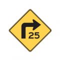
Turn Advisory
-
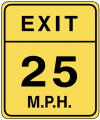
Exit Advisory
-
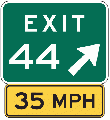
Exit Sign Plaque


Special Speed Limits
As of February 2016[update], the WME and Waze App only support maximum speed limits for passenger vehicles, without variation for time of day, or day of the week. Specialty, also known as 'bannered', speed limits, like the ones shown below, should NOT be added to the Waze map.
-
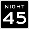
Night Speed
-
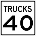
Truck Speed
-
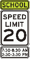
School Speed
-
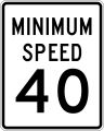
Minimum Speed


| School zone speed limits that are in effect 24 hrs per day, and 365 days a year, should be added to the map. |