This page serves as the primary resource for editors of Maryland. Review all the sections to better understand how the guidelines for this state might deviate from the overall USA or worldwide guidelines. If you have any comments or questions about this page or state refer to the community links below.
The mid-atlantic region now uses Discord for real-time communications.
Join the MAR Discord server here: Discord Invitation
Introduction
Maryland is a part of the Mid Atlantic region, which includes the states and/or territories of:
Before editing the maps in Maryland, be sure to fully review and understand the editing manual.
The Waze user community follows the Waze etiquette guidelines discussed in the Wiki. Be sure to familiarize yourself with these guiding principals while editing the maps and this Wiki, as well as when communicating with other Waze users.
Many interactive maps use basemaps including third-party data (such as ESRI transportation). DO NOT rely on basemap data for street name or route information. Contact a State Manager with questions/concerns.
Statewide
Road type
Please review the USA Functional Classification page and the FC Quick Reference Chart for details on this topic. In rare cases, a particular road may require a different type than prescribed in the national guidance. Before changing the type of any road past the bounds of the rules, please post the situation to the Maryland Forum to receive feedback. Maryland resources can be found in the following links:
In addition to the Census Designated Places that Maryland uses for the City Layer, there are 157 incorporated municipalities. See the Cities and Towns section for Incorporated Cities boundary files to use as WME Map overlays.
Links for Addresses
MD Finder -- From the Layers list select "Parcel Points." Type in the full address (Street, City) then add "Parcel Boundaries" and/ or "Six-Inch Imagery." Click on the green "parcel point" to view address information.
MERLIN (from MD Dept. of Planning) -- Enable the 'Parcel Data' layer. Click on the green "parcel point" to view address information. Additionally, you can find numerous satellite imagery imagery options at the bottom of the layer list.
WME GIS Layers (script) -- This script will add GIS layers to WME for states and counties that provide a public ESRI/ArcGIS interface.
Use these maps for the names of local roads and smaller streets not identified on the state maps. Some also provide house numbers. The most efficient method for determining which resource to utilize is to install the WME GIS script.
The Waze forum is a great place to find answers to previously asked questions and also a place to ask new ones. Below are links to the forums specific to Maryland.
New editors should consider checking into the formal mentoring program available at no charge.
The mid-atlantic region now uses Discord for real-time communications.
Join the MAR Discord server here: Discord Invitation
Real-time chat
The mid-atlantic region now uses Discord for real-time communications. Join the MAR Discord server here: Discord Invitation
Update requests
An Update Request (UR) is a Map Issue reported by a user from the Waze client app. It is also a layer in the Map Editor. See update requests for more information. Maryland has a policy of shared UR management. This means that URs are open to all editors and that there is no "ownership" implied when posting the initial comment. However, it is courteous to allow new editors or editors you don't have an informal agreement with an extra day or two to respond to reporter comments and/or post reminders. Effective UR conversations are usually achieved with a single point of contact for the reporter, but other editors can step in if a UR with reporter comments begins to sit idle or if they think another editor needs help. Please be respectful to other editors and reporters while working URs; it is usually best to send a message to the editor rather than chatting with them through a UR. (Most reporters don't care about the chat, they just want it fixed and not be bothered with multiple responses). Typically, an editor should be given some time to respond to the reporter's comments (since real life has a way to occasionally get in the way to prevent editing time on some days).
Standard URs
In Maryland we have adopted at 0/4/4 system for response to Update Requests. Expand below for an explanation of the 0/4/4 UR system.
Day 0
The first editor who is able to respond to UR should attempt to resolve the UR. If they are successful, they should comment as such in the UR and mark it closed. If more information from the reporter is required to make progress towards closure, a query should be sent to the reporter requesting the information needed for resolution
Day 4+
Polite reminders should be sent to a reporter who has never responded to a query, provided at least three full days have elapsed since the initial response was sent. (You can send reminder at 00:01 Eastern Standard (or Daylight when applicable) Time on the fourth day).
Example
"If no further information is provided we will be unable to fix the issue you encountered and this report will be closed soon"
Second Day 4+
URs may be noted as closed due to lack of reporter response, provided at least three full days have elapsed since the followup message was sent (You can close at 00:01 Eastern Standard (or Daylight when applicable) Time on the fourth day since the reminder was sent)
Example
"This report is being closed due to lack of information, please submit another report if the issue continues. Happy Wazing!"
Speed Limit URs
In Maryland, Speed Limit URs are treated differently than standard URs. Expand below to see the unique handling instructions.
The first user able to respond to a Speed Limit ("SL") UR must evaluate the UR for its applicability to the nearest segment.
If the nearest segment to a SL UR has a Verified SL supported by recent Streetview ("SV") imagery (or other means) OR the speed limit cannot be added due to Waze USA policy (roundabouts, ramps, etc) it should be marked as "NOT IDENTIFIED" and a reply should be sent to the submitter explaining the reason for closing the UR. Examples:
"This speed limit report is being closed because it was on a road segment with an already verified speed limit confirmed using recent street view imagery or other means. If you believe this speed limit is incorrect, please reply in the Waze Map Editor, or at [email]."
"This speed limit report is being closed because it was on a road segment that does not have a legally enforceable speed limit. Only speed limits posted on black and white regulatory signs are added to the app. "
If the SL UR occurs on a road segment with an unverified SL or a SL without recent SV imagery, request confirmation from the user on the SL sign and its location. Examples:
"Can you please confirm your speed limit report on [road name]? We have a speed limit of [existing SL], did you see a different speed limit posted on a regulatory black and white sign?"
"Can you please confirm your speed limit report on [road name]? We don't have any information on speed limits for this road."
SL URs should be revisited after only 1-2 days, and closed after only 3-4 days without a response. Use the closing comment to direct the user on proper SL reporting. Example:
"We have not been able to verify your speed limit report. Please only submit SL reports for roads with incorrect or missing speed limits. Android users can choose to see the SL at all times in the settings menu; iOS users must input the code ##@debugspeed."
Cities and towns
One of the most common errors when editing the maps is when an editor creates a road and does not confirm the road by setting the city and road name (or stating it has none).
There are 157 incorporated places in Maryland. When assigning the city name to a road segment or landmark, use the name of the incorporated place or CDP (census-designated place). If it is outside the boundaries of either of those, set the city name as None. Do not use the names associated with ZIP codes or the name of a neighborhood, community, or subdivision not included on the census map. If the road type is Freeway, set the city as None (except in Baltimore City), regardless of the location, as this helps with routing. Be sure to also set the city name of any alternate names correctly. Please discuss any deviations from this guidance in the Maryland Forum.
Overlay the above boundary file(s) with the WME Geometries Plugin. Load the files in WME from the "Areas" tab; turn on the Roads Layer (to reference existing CDP/ City names) and the cities layer (to view which WME city boundary may need to be modified).
In Maryland we have a set minimum standard for locking roads based on segment type. Any road of a certain segment type must be locked at least to the rank (level) in the chart below. Roads may be locked higher for protection and special situations (areas with construction, tricky design, frequent mistakes, imaging inaccuracies, and the like), but should not be locked lower.
A great time to implement these locks is while bringing the road types of an area into compliance with the current US road type standards (FC and highway systems). Lock the roads based on type after they've been set to current US road type standards.
Maryland Minimum Locking Rank Standard
Segment Type
Two-Way
One-Way
Freeway
5
Ramp
4
Major Highway
4
Minor Highway
3
Primary Street
2
3
Street
1
2
• • • • Ferry • • • •
5
|-|-|-|-|-|-|-|-|-| Railroad |-|-|-|-|-|-|-|-|-|
2
Note that these are minimums and, for protection, certain segments may be at higher lock levels. If you find a road locked to a higher level than its minimum, please leave it locked no lower than that level when you have finished editing.
Headlight use
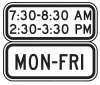
Maryland follows the national guidance for marking road with 24/7 headlight use requirements. This includes tunnels which are properly marked with black and white regulatory signs. In addition to, or in substitution of the FHWA signs shown in the national guidance, Maryland editors may also encounter the following signs:
Maryland follows the national guidelines for adding speed limits to the map. There are a few items left up to local guidance which will be enumerated below.
In Maryland, it is a best practice to map speed limits on all segments primary street and above. Local street segments without a posted speed limit should not have a speed limit added in Waze. This is because the statutory limit (see below) would be between 30-35 mph, and might be confusing to users.
Maryland law
Maryland law includes the following restrictions on the designation of speed limits. [1]
Maximum speed limits are as follows, unless otherwise signed/posted:
District
Highway Type
Undivided
Divided
Business
30 mph
Residential
30 mph
35 mph
Other Locations
50 mph
55 mph
Speed limits may be revised after a traffic study and then posted, but no limit may exceed 70 mph
Maximum speed limits for local jurisdictions include:
15 miles an hour in alleys in Baltimore County
Note: In Maryland, Speed Limits posted on private property are enforceable by law enforcement officers. Include these speed limits on the Waze map.
National guidance recap
The ONLY speed limits which should be added to the map are Regulatory Speed Limits. These are marked with black lettering on white rectangular signs.
'Advisory' or speciality speed limits that are unsupported by the WME and the Waze app, and MUST NOT be added to road segments in the WME, including:
Advisory speeds
Truck speed limits
Night speed limits
Segments with time based different speed limits should use the speed limit which is in effect the majority of the time (most hours of the day, days of the week).
Speed limits should change where they legally go in effect. When a speed limit changes in the middle of a segment, a new junction should added to support the SL change. However a new junction should never be added for a SL if it will be within 200 feet of an existing junction, or potential junction.
Work zone speed limits
A work zone (WZ) may have a lower advisory speed limit (SL) posted in black on orange
, or a regulatory speed limit posted in black on white with an orange "Work Zone" banner across the top .
We only consider the regulatory signs, and never map advisory speed limits.
Adding WZ SLs to segments is generally allowed.
Typically only projects which are expected to last at least 3 months should be added to the map.
The underlying SL, and expected project completion date should be documented in a map comment
Projects of shorter duration may be added as well, IF the editor has access to frequent status updates on the project, and is willing to monitor and adjust as soon as the SL is restored.
Where speed limits change
The Maryland supplement to the MUTCD stipulates that: A Speed Limit sign in a speed zone shall be located at or just beyond the point where the zone begins. If the zone begins at an intersection, the first Speed Limit sign for that zone shall be the Speed Limit sign normally erected beyond the intersection conforming to the standard sequence of signs at intersections.[2]
Maryland is a state where the speed limits are absolute and are enforceable from statute; speed limits need-not be posted to be enforced.
When adding speed limits to WME we should try to be as accurate as reasonable, while still preserving data for turn delays. Therefore if a speed limit changes in middle of a segment we will create a new junction to support the SL change. However if there is already an existing junction, or we can see the need to create a new junction to connect another segment to the road within 200 feet of the speed limit sign, we should mark the SL change using that existing (potential) junction node.
If at the editor's discretion in consultation with local managers, it is determined that a new junction to support a SL change between 200 - 1,000 feet away from a junction would have a negative impact on turn delay calculations, they may instead affect the SL change at an existing (potential) junction up to 1,000 feet away from the SL sign. This may be because the SL change is posted in middle of turning or exit lane where traffic regularly backs up from the following junction to before the position of the SL sign.
Whitehaven PermaLinkUpper PermaLink Website
Hours: Mon-Sun: March 1st to May 15th, 7am - 6pm May 16th to September 15th, 6am - 7:30pm September 16th to October 31st, 7am - 6pm November 1st to February 28th, 7am - 5:30pm
Ferry ramp segments updated thru February 2020
Oxford Bellevue Ferry
PermaLink Website
Hours:
7 Days a Week; First Boat 9:00 a.m. Oxford; Last Boat Sunset
2016: April 27, 2019 to Mid-November (November is Sat/Sun only)
Update Ferry Segment Closure annually
Reversible Roads
This section highlights some of the roads in the region that special traffic restrictions. See this WTOP article for more information on Reversible Roads in the region.
Clara Barton Parkway / Canal Road
The Clara Barton Parkway and Canal Road from Bethesda to Washington DC maintain one-way traffic during Rush Hours. but allow 2-way traffic for Federal Holidays.
Traffic restrictions along these segments MUST be maintained by a responsible editor to account for these weekday holidays! Western Permalink Eastern Permalink
Closures
When managing a section of roadway under construction or being closed for a major event, follow the Wiki guidelines on construction zones and Real time closures.
Major Traffic Events are now created within WME. See the linked Wazeopedia page.
Places
Maryland follows the USA standard for Places. Do not deviate from the guidelines without first obtaining consensus to do so via the state forum linked on this page.
Cameras
Not every camera-looking device at an intersection is a speed or red light camera. Generally speaking:
a speed camera takes a photograph of a vehicle when it passes by the camera at too high a speed.
a red light camera takes a photograph of a vehicle that enters an intersection after the light is red. In some areas, it takes the photograph when a vehicle is not clear of the intersection some period after the light turns red.
When adding a camera, be sure to review the camera placement recommendations.
Laws regarding speed and red light cameras vary between the states and territories, so be sure to understand the details of camera legality in Maryland.
Based on information researched at the time this page was created, the limited legality of speed cameras in Maryland is described below, and red light cameras are legal statewide in Maryland.
No other camera types should be mapped in Waze.
Speed cameras
Speed cameras are authorized for use in the following areas: school zones throughout the state, work zones on freeways and major highways, and on streets in Montgomery County. Speed cameras can be mounted to a pole, concealed in a metal cabinet on the ground, or mounted on a trailer or vehicle parked on the shoulder, such as these used in work zones. Most speed cameras in Maryland will not issue a ticket unless the vehicle is exceeding the speed limit by at least 12 mph; however, when setting the speed of a camera in the editor, use the speed limit of the road.
Many speed cameras are portable and moved on a regular basis, in some cases weekly. This is usually indicated on the website and may include a rotation schedule. These reported camera locations should not be on the map. However, if the speed camera is not portable or is not moved on a regular basis, then it should be on the map. Check the County-based links below.
Red light cameras
Red light cameras are authorized for use throughout the state. Please note that each red light camera fixture only records violations in one direction, so be sure to check which direction(s) are enforced, and include a camera in the editor for each applicable direction.
Some red light cameras also include radar, and enforce speed limits. This is especially true in Baltimore City.
The Wiki page for Waze Cameras states that, Speed limits "can also be set for a Red Light Camera if it monitors for Speed Limit Violations as well. Leave set to blank if speed is not monitored." However, this function has not been confirmed in the client.
Other camera types
These are cameras or signs that either provide driver feedback or are used for traffic control. These devices cannot issue tickets and should not be mapped. However TRAFFIC Cameras can be used to monitor emergency closures (for accidents, etc.) See below.
These lists are posted for your reference, but should not be used to justify the approval of cameras in Waze Map Editor without first verifying the location and type of camera by other means, and that it is not part of a school zone speed camera program in a jurisdiction where the cameras are relocated on a regular basis. The lists may not be up to date, and may include all locations where cameras are permitted, but does not mean that a camera is present at that location at all times.
To do list
Many states and territories keep an active list of pending or closed actions that need to be done in the state by the editors. All editors are welcome to contribute to the list of activities.
Visit the Maryland/To do page for ways to contribute to the map.
Other
U-Turns
The Waze Map Editor allows the enabling or restricting of U-turns using the green or red u-turn icons. U-Turns are legal in maryland with the following restrictions:
MD Transportation Code § 21-402(b) Vehicle turning left or making U-turn
(b) U-turn. -- If the driver of a vehicle intends to turn to go in the opposite direction, the driver shall yield the right-of-way to any approaching vehicle that is so near as to be an immediate danger.
MD Transportation Code § 21-602 U-turn on curve or crest of grade prohibited
(a) Curves. -- The driver of a vehicle on any curve may not turn to go in the opposite direction if the vehicle cannot be seen by the driver of any other vehicle that is within 500 feet and approaching from either direction.
(b) Crests. -- The driver of a vehicle on or approaching the crest of any grade may not turn to go in the opposite direction if the vehicle cannot be seen by the driver of any other vehicle that is within 500 feet and approaching from either direction.
Area Managers
The table below identifies the editors also designated as Area Managers or higher who are editing in Maryland. If you have any questions, please consider contacting them directly as needed. If you are an Area Manager that covers Maryland, or a USA Country Manager that does a lot of work in Maryland, please add yourself to this list (alphabetical by username) in the correct rank section.
The editor who also serves as the Regional Coordinator for Maryland is automatically listed at the top of the table. That editor may not be highly active in this state and therefore may not be listed separately in the table.
Maryland — Area, State, Country Managers, and Regional Coordinators
Crofton, Bowie, Laurel, College Park, Odenton, Severna Park, Annapolis
The following editors are also editing in the state and may be working towards an Area Manager position. Feel free to contact them for assistance in their respective areas.