No edit summary |
|||
| (31 intermediate revisions by 2 users not shown) | |||
| Line 1: | Line 1: | ||
== | == Virginia 2025 goal == | ||
The primary goal of the '''Virginia 2025''' is to vastly improve a user's drive by having the destination's '''ADDRESS''' properly located and searchable within the app. | The primary goal of the '''Virginia 2025''' is to vastly improve a user's drive by having the destination's '''ADDRESS''' properly located and searchable within the app. | ||
=== | === Goal scope and discussion === | ||
Yes, this is a large project, but taking small bites (in this case each bite is a permalink at zoom=2) will allow us to complete this grand quest. Virginia 2025 is designed to do this effort in a managable and controlled manner. Businesses come and go, but until a building is torn down and/or rebuilt the address will generally remain the same; therefore getting all the residential and business addresses properly mapped will have a significant and lasting effect for all current and future Wazers. | Yes, this is a large project, but taking small bites (in this case each bite is a permalink at zoom=2) will allow us to complete this grand quest. Virginia 2025 is designed to do this effort in a managable and controlled manner. Businesses come and go, but until a building is torn down and/or rebuilt the address will generally remain the same; therefore getting all the residential and business addresses properly mapped will have a significant and lasting effect for all current and future Wazers. | ||
| Line 14: | Line 14: | ||
=== Basemap items === | === Basemap items === | ||
#*Please review the [[Basemap|Basemap Wiki]] for steps to, and a guide for, editing basemap/connectivity | #*Please review the [[Basemap|Basemap Wiki]] for steps to, and a guide for, editing basemap/connectivity | ||
#*For R1 and R2 editors who have deletion restrictions, remember that merging two segments together is not considered a deletion. Only merge if the road data will not be corrupted for the remaining segment(s), but if there are many segments that do not belong (powerline right of ways, rivers, etc) then combine them into one segment that can be deleted at the end of your editing day. | #*For R1 and R2 editors who have deletion restrictions, remember that merging two segments together is not considered a deletion. Only merge if the road data will not be corrupted for the remaining segment(s), but if there are many segments that do not belong (powerline right of ways, rivers, etc) then combine them into one segment that can be deleted at the end of your editing session/day. | ||
#*In addition to the steps in the Basemap wiki, please pay special attention to the following: | #*In addition to the steps in the Basemap wiki, please pay special attention to the following: | ||
#**Verify road names and verify/add appropriate street and city alt-names | #**Verify road names and verify/add appropriate street and city alt-names | ||
| Line 20: | Line 20: | ||
#**Add Speed Limits (SL) - Virginia's default is 25 mph with incorporated city/town/village limits. 55 mph in rural areas. Remember you can also use nearby streets with streetview to get a feel for what the typcial speed is in the area. | #**Add Speed Limits (SL) - Virginia's default is 25 mph with incorporated city/town/village limits. 55 mph in rural areas. Remember you can also use nearby streets with streetview to get a feel for what the typcial speed is in the area. | ||
== | == Virginia 2025 spreadsheet == | ||
The picture to the right is Virginia as made up of permalinks within a spreadsheet. Each editor participating in Virginia 2025 should select one area at a time. Zoom=2 was selected to give a decent amount of area to work but not be so overwhelming that you will never complete the area. Since permalinks are different sizes based on an editor's computer settings. The magnification of the screen plays into account so selecting two adjacent PLs may leave a gap in coverage on your screen while there is overlap on another editors' screen. | [[File:Virginia_2025_PL_Map.PNG|300px|right]]The picture to the right is Virginia as made up of permalinks within a spreadsheet. Each editor participating in Virginia 2025 should select one area at a time. Zoom=2 was selected to give a decent amount of area to work but not be so overwhelming that you will never complete the area. Since permalinks are different sizes based on an editor's computer settings. The magnification of the screen plays into account so selecting two adjacent PLs may leave a gap in coverage on your screen while there is overlap on another editors' screen. | ||
Note some areas have overlap with neighboring states, some areas have only water, and some areas have very few roads. So like these are like Forrest Gump's box of chocolates, "You never know what you' | Note some areas have overlap with neighboring states, some areas have only water, and some areas have very few roads. So like these are like Forrest Gump's box of chocolates, "You never know what you're gonna get" until you jump in and look at it. | ||
=== Selecting an area === | === Selecting an area === | ||
* Select '''''ONE''''' area that you want to work on. | * Select '''''ONE''''' area that you want to work on. | ||
* Preferentially pick an area that is already within your editing area. (Driving/AM/LAM) | |||
* Copy the permalink and look at it on your computer. | * Copy the permalink and look at it on your computer. | ||
* If you like that area: | * If you like that area: | ||
** Change the background color to yellow for your chosen area on the first tab "PL Map". | ** Change the background color to yellow for your chosen area on the first tab "PL Map". | ||
** Change to the spreadsheet's second tab, "Editor Assignment", and overwrite your editor name | ** Change to the spreadsheet's second tab, "Editor Assignment", and overwrite the PL with your editor name. | ||
* Commence editing in the area, if you already have editing rights. | * Commence editing in the area, if you already have editing rights. | ||
* If | ** If all areas in your editing area are done, then you may submit for an Area Manager expansion by using the [https://docs.google.com/forms/d/e/1FAIpQLSd95_HHfhitLmIEBjOgJc1wtb9z1qINrtRTBbYV0jsAo4W9Tg/viewform?c=0&w=1 Area Manager application] to the MAR Regional Coordinator. | ||
** Note the submission for AM will go through the normal AM request process for review and needs to meet the normal AM request requirements. | |||
** The AM will be a permanent AM assignment, it is not a temporary Virginia 2025 area; this is not a map raid for two weeks. | |||
=== Edit the area === | === Edit the area === | ||
| Line 54: | Line 58: | ||
*** A WME house number does not provide proper routing to a place that is not on the named road segment | *** A WME house number does not provide proper routing to a place that is not on the named road segment | ||
*** Another house exists within Virginia's borders with the same house number, road name, '''AND''' the primary city is ''None''; you will receive an error message that the HN already exisits and you cannot force the Save. | *** Another house exists within Virginia's borders with the same house number, road name, '''AND''' the primary city is ''None''; you will receive an error message that the HN already exisits and you cannot force the Save. | ||
=== Finished the area === | |||
** Change your area's background color to '''GREEN''' for your chosen area on the first tab "PL Map". | |||
** Change to the spreadsheet's second tab, "Editor Assignment"; leave your editor name there and change the background color to '''GREEN'''. | |||
** A good way to see if you have done all of the area is to use JustinS83's [https://greasyfork.org/en/scripts/27035-wme-beenthere| Been There script]. Make a box around the PL at zoom=2 and then zoom into one corner and mark it with a box, survey/scan to make sure all segments are complete. Move to the edge of the smaller box and then mark the new section and survey/scan; repeat as necessary. Once all the larger box is filled in with the smaller boxes. then your area is complete. [[File:Been There Boxes.PNG|300px|center]] | |||
** Had fun and want some more? Then go ahead and grab your next one! | |||
== Communication == | == Communication == | ||
''Discord '' is the primary means to communicate during this effort. '''You must be in the [[MAR]] Discord server to participate in Virginia 2025.''' | ''Discord '' is the primary means to communicate during this effort. '''You must be in the [[MAR]] Discord server to participate in Virginia 2025.''' | ||
Therefore, if not already on the MAR Discord server, then please request to join by filling out [https://docs.google.com/forms/d/e/1FAIpQLSc9Z1yeGdfzrzUHHUM05X7kuqxfWipgNmr8WLFfnn2m4QSgkA/viewform the MAR Discord request form]. | Therefore, if not already on the MAR Discord server, then please request to join by filling out [https://docs.google.com/forms/d/e/1FAIpQLSc9Z1yeGdfzrzUHHUM05X7kuqxfWipgNmr8WLFfnn2m4QSgkA/viewform '''the MAR Discord request form''']. | ||
But since some don't have 24/7 access to Discord you '''CAN''' edit while not able to be on Discord temporarily. Please [[Waze Map Editor/Chat#Visible.2FInvisible|set yourself visible]] and enable the [[Map Editor Interface and Controls#Live Users|Live Users]] layer when editing in Virigina. That way people can see you via Live Users and reach out via WME Chat if required; additionally ask to be added to the Virginia Google Hangout channel, if GHO is available to you, since it is synched to Discord. | But since some don't have 24/7 access to Discord you '''CAN''' edit while not able to be on Discord temporarily. Please [[Waze Map Editor/Chat#Visible.2FInvisible|set yourself visible]] and enable the [[Map Editor Interface and Controls#Live Users|Live Users]] layer when editing in Virigina. That way people can see you via Live Users and reach out via WME Chat if required; additionally ask to be added to the Virginia Google Hangout channel, if GHO is available to you, since it is synched to Discord. | ||
If you do not understand anything, | Virginia 2025 is not a map raid; therefore it will not have specific group leaders. Please ask your questions or post up/downlock requests in the Virginia Discord channel/GHO. | ||
If you do not understand anything, please askǃ If you need help figuring out where to start, please askǃ If you think you did something correctly, but aren't sure, please askǃ The MAR community is more than happy to help resolve your question/concern and more than likely there is someone else who is pondering the same item. | |||
== Editor restrictions == | == Editor restrictions == | ||
=== | === R1/R2 editor restrictions === | ||
Welcome R1 and R2 editors and thanks for your participation in the | Welcome R1 and R2 editors and thanks for your participation in the Virginia 2025. We know how frustrating it can be to not be able to delete (or do many name changes on) segments that you did not create. We feel your pain, but this is a long term project so relax, you can get to it tomorrow. If you absolutely positively need us to address it now, just ask in Discord and we'll be more than happy to help with deletions or renamings. | ||
''' | '''Complete each segment before moving on'''. When you find a point on the map to do an edit, please take the time to finish all the associated items with that edit before moving on. The basemap wiki is an excellent checklist for editing roads even if you are working on a road that is not basemap. | ||
==Local Guidance== | ==Local Guidance== | ||
=== | === VA Roads/Routes === | ||
Road names in | Road names in Virginia use the noun name as the primary segment name with the route number as an alternate. If addresses are using the route number AND there is signage for the route number but not the noun name then the route number can be the primary name. Follow the nationwide [[Road names/USA|Road Name]] guidance. Pay specific attention to the list of approved [[Abbreviations and acronyms]], and when in doubt: "spell it out". If you have any other questions or concerns please contact a MAR Large Area Manager or a MAR State Manager. | ||
# The city name for the primary name is either the incorporated city/town/village name, CDP name, or None. | |||
# If the segment falls within an incorporated city/town/village or CDP, then '''all''' alternate segment names should also include the same primary city name for the city/town/village/CDP. | |||
# If the segment falls outside of a city/town/village/CDP, then the primary city name should be left blank and the "None" check box selected. The segment's primary road name should be duplicated in the alternates and '''all''' alternate names should use the USPS Zip Code City name. Do not check "None" for any of the alternate city names. If there is more than one listed USPS Zip Code City for a given ZIP, use the city name used for that address. Using another "default" name will mean the Waze house number or residential place point is not used. | |||
# If the segment runs along the border between two cities or CDPs, then the primary city name should be left blank and the "None" check box selected. The primary segment name should be duplicated in the alternates for both city/CDP names as well as the alternate segment names. Do not check "None" for any of the alternate city names. This guidance should also be applied when the segment falls outside of a city/CDP but borders two USPS Zip Code City. | |||
# The city name for the primary name is either the | |||
# If the segment falls within | |||
# If the segment falls outside of a | |||
# If the segment runs along the border between two | |||
==== Alleys ==== | ==== Alleys ==== | ||
Alleys in | Alleys in Virginia follow the MAR guidance for [[USA/Mid Atlantic#Road Segment Naming|Alleys]]. '''Do NOT use the new road type "Narrow Street/Alley" in Virginia.''' | ||
=== Functional Classification === | === Functional Classification === | ||
Information on functional classification in | Information on functional classification in Virginia can be found [[usa:Virginia/Major_roads#Functional_Classification|here]]. For editors rank 3 and above see the functional classification script in the Virginia Wazeopedia page. | ||
=== MAR Minimum Road Lock Standard === | === MAR Minimum Road Lock Standard === | ||
{| class="wikitable" style="text-align:center" | {| class="wikitable" style="text-align:center" | ||
| Line 397: | Line 150: | ||
Note that these are minimums and, for protection, certain segments may be at higher lock levels. If you find a road locked to a higher level than its minimum, please | Note that these are minimums and, for protection, certain segments may be at higher lock levels. If you find a road locked to a higher level than its minimum, please ask for clarification. | ||
=== | === Virginia Update Request Management === | ||
This will not be a "''primary focus''" of the | This will not be a "''primary focus''" of the Virginia 2025, but please feel free to work any UR/PUR/MP's in your editable area. If you receive an AM assignment then the UR/PUR/MP's are definitely within that role, so jump in. Remember to follow the [[usa:Virginia_User_Report_Management| Virginia Response Timeline]]. | ||
=== Cameras === | === Cameras === | ||
''' | '''Very few cameras will not be mapped''' | ||
Most places in Virginia do not allow red light cameras. Special permission has to be obtained to have them. You may see some fake cameras on the map. Cameras that were in place have been left as a visual deterrent; therefore they are marked as fake. Virginia does not allow speed cameras. | |||
=== Place Editing === | === Place Editing === | ||
Virginia follows the national [[Places]] guidance. | |||
For specific | For specific VA naming standards please review the [[Virginia#Naming_Standards| VA Naming Standards]] | ||
To prevent loss of data due to automatic acceptance of submissions from "trusted users", all area places and points with complete data should be locked to Level 2 at a minimum. | To prevent loss of data due to automatic acceptance of submissions from "trusted users", all area places and points with complete data should be locked to Level 2 at a minimum. | ||
| Line 436: | Line 189: | ||
== Reference Links == | == Reference Links == | ||
=== | === Virginia Wazeopedia Page === | ||
If you have any questions regarding | If you have any questions regarding VA standards during editing and you cannot find the answer on this page, please visit the [[Virginia|Virginia Wazeopedia Page]] and/or the [[USA/Mid Atlantic|MAR Wiki Page]]. | ||
=== Recommended Tools for | === Recommended Tools for Virginia 2025 === | ||
There are many scripts and extensions that editors use to assist with editing that not only make some jobs easier, but verifies what we do is correct. The use of these scripts is highly encouraged and those listed below are the ones you should install, at a minimum, to get started. | There are many scripts and extensions that editors use to assist with editing that not only make some jobs easier, but verifies what we do is correct. The use of these scripts is highly encouraged and those listed below are the ones you should install, at a minimum, to get started. | ||
| Line 454: | Line 205: | ||
You will need to install a browser extension to manage the additional scripts. Some scripts do not work with the current version of GreaseMonkey, so we recommend [[Scripts#General_installation_instructions|installation of TamperMonkey]]. | You will need to install a browser extension to manage the additional scripts. Some scripts do not work with the current version of GreaseMonkey, so we recommend [[Scripts#General_installation_instructions|installation of TamperMonkey]]. | ||
'''Essential scripts''' | '''Essential scripts''' | ||
# [http://greasyfork.org/en/scripts/25631-wme-us-government-boundaries WME US Government Boundaries] displays USPS Zip Code boundaries and County boundaries. | # [http://greasyfork.org/en/scripts/25631-wme-us-government-boundaries WME US Government Boundaries] displays USPS Zip Code boundaries and County boundaries. | ||
# [https://greasyfork.org/en/scripts/40837-wme-cities-overlay WME Cities Overlay] provides outlines of CDPs in | # [https://greasyfork.org/en/scripts/40837-wme-cities-overlay WME Cities Overlay] provides outlines of CDPs in Virginia. | ||
# [https://greasyfork.org/en/scripts/21228-wme-gis-buttons WME GIS Buttons script] links to the multiple County GIS websites. | # [https://greasyfork.org/en/scripts/21228-wme-gis-buttons WME GIS Buttons script] links to the multiple County GIS websites. | ||
#[https://greasyfork.org/en/scripts/ | #[https://greasyfork.org/en/scripts/369632-wme-gis-layers WME GIS Layers] adds GIS layers to WME for states and counties that provide a public ESRI/ArcGIS interface. Typically, these layers include tax parcels (often with address labels) and/or address points. | ||
# [https://chrome.google.com/webstore/detail/wme-validator/baojhpeknpmkhplkcnpdcficcaaniaih WME Validator] validates a map area & highlights issues and generates a very detailed report with WOP references and solutions. | |||
# [https://greasyfork.org/en/scripts/14674-wme-validator-virginia-localization-2 WME Validator Virginia Localization] this is an add-on script to Validator | |||
{{mbox|type=important|text= WME US Government Boundaries layer will display the '''ESTIMATED''' USPS city name for the '''CENTER''' of the displayed screen. At the boundaries it can be inaccurate. Some areas shifting a few pixels can change the city name between four different cities (or a few states). So remember it is a tool and can be checked with individual addresses by checking the zip code for an address.}} | |||
If you prefer, the CDP outlines can be loaded into WME using the [https://greasyfork.org/en/scripts/8129-wme-geometries WME Geometries script | If you prefer, the CDP outlines can be loaded into WME using the [https://greasyfork.org/en/scripts/8129-wme-geometries WME Geometries script]. | ||
'''Other Recommended Scripts''' | '''Other Recommended Scripts''' | ||
#[https://greasyfork.org/en/scripts/38921-wme-status-always-visible WME status always visible] will ensure you are visible while working on the | #[https://greasyfork.org/en/scripts/38921-wme-status-always-visible WME status always visible] will ensure you are visible while working on the Virginia 2025 project. | ||
# [https://waze.xpto.org/magic/ Magic] is a tool for highlighting additional errors. | # [https://waze.xpto.org/magic/ Magic] is a tool for highlighting additional errors. | ||
# [http://greasyfork.org/en/scripts/21779-wme-hn-tool-justins83-fork WME HN Tool (JustinS83 fork)] highlights un-nudged house numbers. | # [http://greasyfork.org/en/scripts/21779-wme-hn-tool-justins83-fork WME HN Tool (JustinS83 fork)] highlights un-nudged house numbers. | ||
# [https://greasyfork.org/scripts/21378-wme-quick-hn/code/WME%20Quick%20HN.user.js Quick HN] Allows you to set starting HN and then go up by +1 (T), +2 (R), or user selected increment (E) | |||
# [https://greasyfork.org/en/scripts/35547-wme-junction-angle-info WME Junction Angle Info] helps with junction maintenance. If two connected segments are selected, it shows the turn angle, and estimates navigation instructions. Otherwise it shows the the angle between each segment. | # [https://greasyfork.org/en/scripts/35547-wme-junction-angle-info WME Junction Angle Info] helps with junction maintenance. If two connected segments are selected, it shows the turn angle, and estimates navigation instructions. Otherwise it shows the the angle between each segment. | ||
# [http://greasyfork.org/en/scripts/18089-wme-simple-permalink-from-wme-keepmylayers WME Simple Permalink] shortens WME permalinks by removing any layer and filter specifications. | # [http://greasyfork.org/en/scripts/18089-wme-simple-permalink-from-wme-keepmylayers WME Simple Permalink] shortens WME permalinks by removing any layer and filter specifications. | ||
# [http://github.com/WazeUSA/WME-Place-Harmonizer/raw/master/WME-Place-Harmonizer.user.js Place Harmonizer (WMEPH)]. harmonizes, formats and locks a selected place. | # [http://github.com/WazeUSA/WME-Place-Harmonizer/raw/master/WME-Place-Harmonizer.user.js Place Harmonizer (WMEPH)]. harmonizes, formats and locks a selected place. | ||
# [https://greasyfork.org/en/scripts/28097-wme-fs-mvum-gis-map/ WME FS MVUM GIS Map] opens a Forest Service Motor Vehicle Use Map in another window, at the same location as the WME map. Keeps the location of the GIS map synced to WME. | # [https://greasyfork.org/en/scripts/28097-wme-fs-mvum-gis-map/ WME FS MVUM GIS Map] opens a Forest Service Motor Vehicle Use Map in another window, at the same location as the WME map. Keeps the location of the GIS map synced to WME. | ||
Latest revision as of 16:29, 27 February 2019
Virginia 2025 goal
The primary goal of the Virginia 2025 is to vastly improve a user's drive by having the destination's ADDRESS properly located and searchable within the app.
Goal scope and discussion
Yes, this is a large project, but taking small bites (in this case each bite is a permalink at zoom=2) will allow us to complete this grand quest. Virginia 2025 is designed to do this effort in a managable and controlled manner. Businesses come and go, but until a building is torn down and/or rebuilt the address will generally remain the same; therefore getting all the residential and business addresses properly mapped will have a significant and lasting effect for all current and future Wazers.
The desire is to get the road segments (base map and urban/suburban) to have proper road names, proper city name(s), direction(s) of travel, turn restrictions, house numbers, and speed limits. This effort improves the connectivity of the Waze map while making the destination addresses work properly. Note when a house number doesn't provide proper routing then use a residential place point (RPP), but only if absolutely necessary.
Since the Virginia 2025 effort can take a few passes on a road to get it groomed to standards, this is a slow methodical effort and not a fast dash. You will be working on all sorts of regions from major metropolitan areas (Northern Virginia/Richmond/Norfolk/etc) to basemap in the wilds of western Virginia. So there is something for everyone's particular taste.
Mapping will never achieve perfection, since there is always some change going on throughout the Commonwealth of Virginia. Construction of new homes and their roads, improving major highways with diverging diamond interchanges, and even adding Express Lanes or HOV Lanes are fairly common occurances. But the goal is to get as close to a snapshot of perfection as can be achieved. Most areas will stay in that perfection mode for a long long time.
Basemap items
- Please review the Basemap Wiki for steps to, and a guide for, editing basemap/connectivity
- For R1 and R2 editors who have deletion restrictions, remember that merging two segments together is not considered a deletion. Only merge if the road data will not be corrupted for the remaining segment(s), but if there are many segments that do not belong (powerline right of ways, rivers, etc) then combine them into one segment that can be deleted at the end of your editing session/day.
- In addition to the steps in the Basemap wiki, please pay special attention to the following:
- Verify road names and verify/add appropriate street and city alt-names
- Look for and correct other state names on segments (MD/WV/KY/TN/NC/DC)
- Add Speed Limits (SL) - Virginia's default is 25 mph with incorporated city/town/village limits. 55 mph in rural areas. Remember you can also use nearby streets with streetview to get a feel for what the typcial speed is in the area.
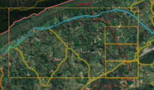
Virginia 2025 spreadsheet

The picture to the right is Virginia as made up of permalinks within a spreadsheet. Each editor participating in Virginia 2025 should select one area at a time. Zoom=2 was selected to give a decent amount of area to work but not be so overwhelming that you will never complete the area. Since permalinks are different sizes based on an editor's computer settings. The magnification of the screen plays into account so selecting two adjacent PLs may leave a gap in coverage on your screen while there is overlap on another editors' screen.
Note some areas have overlap with neighboring states, some areas have only water, and some areas have very few roads. So like these are like Forrest Gump's box of chocolates, "You never know what you're gonna get" until you jump in and look at it.
Selecting an area
- Select ONE area that you want to work on.
- Preferentially pick an area that is already within your editing area. (Driving/AM/LAM)
- Copy the permalink and look at it on your computer.
- If you like that area:
- Change the background color to yellow for your chosen area on the first tab "PL Map".
- Change to the spreadsheet's second tab, "Editor Assignment", and overwrite the PL with your editor name.
- Commence editing in the area, if you already have editing rights.
- If all areas in your editing area are done, then you may submit for an Area Manager expansion by using the Area Manager application to the MAR Regional Coordinator.
- Note the submission for AM will go through the normal AM request process for review and needs to meet the normal AM request requirements.
- The AM will be a permanent AM assignment, it is not a temporary Virginia 2025 area; this is not a map raid for two weeks.
Edit the area
- Enter/verify correct road names, including proper abbreviations used
- Enter proper city name(s)
- Primary city name is:
- City/village/town if with incorporated boundary
- Census Designated Place if matches USPS mailing address city
- None if not either of the above options
- Alternate city name is:
- The USPS city name if different than the primary city listed above
- A second city name if road segment is on the boder between areas that meet the first two primary cities above
- Primary city name is:
- Edit the segment for correct direction(s) of travel
- Edit the segment for proper turn restrictions, including time based turn restictions
- Edit the segment for proper time based segment restrictions if applicable
- Verify the segment's road type compared to the VDOT functional classification
- Add/edit the segment for house numbers
- Use WME house numbers if at all possible
- Use a residential place point if
- A WME house number does not provide proper routing to a place that is not on the named road segment
- Another house exists within Virginia's borders with the same house number, road name, AND the primary city is None; you will receive an error message that the HN already exisits and you cannot force the Save.
Finished the area
- Change your area's background color to GREEN for your chosen area on the first tab "PL Map".
- Change to the spreadsheet's second tab, "Editor Assignment"; leave your editor name there and change the background color to GREEN.
- A good way to see if you have done all of the area is to use JustinS83's Been There script. Make a box around the PL at zoom=2 and then zoom into one corner and mark it with a box, survey/scan to make sure all segments are complete. Move to the edge of the smaller box and then mark the new section and survey/scan; repeat as necessary. Once all the larger box is filled in with the smaller boxes. then your area is complete.
- Had fun and want some more? Then go ahead and grab your next one!

Communication
Discord is the primary means to communicate during this effort. You must be in the MAR Discord server to participate in Virginia 2025.
Therefore, if not already on the MAR Discord server, then please request to join by filling out the MAR Discord request form.
But since some don't have 24/7 access to Discord you CAN edit while not able to be on Discord temporarily. Please set yourself visible and enable the Live Users layer when editing in Virigina. That way people can see you via Live Users and reach out via WME Chat if required; additionally ask to be added to the Virginia Google Hangout channel, if GHO is available to you, since it is synched to Discord.
Virginia 2025 is not a map raid; therefore it will not have specific group leaders. Please ask your questions or post up/downlock requests in the Virginia Discord channel/GHO.
If you do not understand anything, please askǃ If you need help figuring out where to start, please askǃ If you think you did something correctly, but aren't sure, please askǃ The MAR community is more than happy to help resolve your question/concern and more than likely there is someone else who is pondering the same item.
Editor restrictions
R1/R2 editor restrictions
Welcome R1 and R2 editors and thanks for your participation in the Virginia 2025. We know how frustrating it can be to not be able to delete (or do many name changes on) segments that you did not create. We feel your pain, but this is a long term project so relax, you can get to it tomorrow. If you absolutely positively need us to address it now, just ask in Discord and we'll be more than happy to help with deletions or renamings.
Complete each segment before moving on. When you find a point on the map to do an edit, please take the time to finish all the associated items with that edit before moving on. The basemap wiki is an excellent checklist for editing roads even if you are working on a road that is not basemap.
Local Guidance
VA Roads/Routes
Road names in Virginia use the noun name as the primary segment name with the route number as an alternate. If addresses are using the route number AND there is signage for the route number but not the noun name then the route number can be the primary name. Follow the nationwide Road Name guidance. Pay specific attention to the list of approved Abbreviations and acronyms, and when in doubt: "spell it out". If you have any other questions or concerns please contact a MAR Large Area Manager or a MAR State Manager.
- The city name for the primary name is either the incorporated city/town/village name, CDP name, or None.
- If the segment falls within an incorporated city/town/village or CDP, then all alternate segment names should also include the same primary city name for the city/town/village/CDP.
- If the segment falls outside of a city/town/village/CDP, then the primary city name should be left blank and the "None" check box selected. The segment's primary road name should be duplicated in the alternates and all alternate names should use the USPS Zip Code City name. Do not check "None" for any of the alternate city names. If there is more than one listed USPS Zip Code City for a given ZIP, use the city name used for that address. Using another "default" name will mean the Waze house number or residential place point is not used.
- If the segment runs along the border between two cities or CDPs, then the primary city name should be left blank and the "None" check box selected. The primary segment name should be duplicated in the alternates for both city/CDP names as well as the alternate segment names. Do not check "None" for any of the alternate city names. This guidance should also be applied when the segment falls outside of a city/CDP but borders two USPS Zip Code City.
Alleys
Alleys in Virginia follow the MAR guidance for Alleys. Do NOT use the new road type "Narrow Street/Alley" in Virginia.
Functional Classification
Information on functional classification in Virginia can be found here. For editors rank 3 and above see the functional classification script in the Virginia Wazeopedia page.
MAR Minimum Road Lock Standard
| Minimum Road Lock Standard | ||
|---|---|---|
| Segment Type | Direction | Lock |
| Freeway | 5 | |
| Ramp | 4 | |
| Major Highway | 4 | |
| Minor Highway | 3 | |
| Primary Street | One-way Two-Way |
3 2 |
| Street Private Road | One-way Two-Way |
2 1 |
| |-|-|-|-|-|-|-|-|-| Railroad |-|-|-|-|-|-|-|-|-| | 2 | |
| • • • • Ferry • • • • | 5 | |
| ⁃ ⁃ ⁃ ⁃ ⁃ Runway ⁃ ⁃ ⁃ ⁃ ⁃ | 4 | |
| Other Named Types | 5 | |
Note that these are minimums and, for protection, certain segments may be at higher lock levels. If you find a road locked to a higher level than its minimum, please ask for clarification.
Virginia Update Request Management
This will not be a "primary focus" of the Virginia 2025, but please feel free to work any UR/PUR/MP's in your editable area. If you receive an AM assignment then the UR/PUR/MP's are definitely within that role, so jump in. Remember to follow the Virginia Response Timeline.
Cameras
Very few cameras will not be mapped
Most places in Virginia do not allow red light cameras. Special permission has to be obtained to have them. You may see some fake cameras on the map. Cameras that were in place have been left as a visual deterrent; therefore they are marked as fake. Virginia does not allow speed cameras.
Place Editing
Virginia follows the national Places guidance.
For specific VA naming standards please review the VA Naming Standards
To prevent loss of data due to automatic acceptance of submissions from "trusted users", all area places and points with complete data should be locked to Level 2 at a minimum. Additionally, please consult the following table for minimum lock level for completed places.
| Place Type | Minimum Lock Level |
|---|---|
| Area/Point Places | 2 |
| Gas Stations | 3 |
| Hospital/Medical Care | 4 |
| Fire Department | 4 |
| Police Station | 4 |
| Airports | 4 |
| Parking Lot Area (PLA) | 3 |
Reference Links
Virginia Wazeopedia Page
If you have any questions regarding VA standards during editing and you cannot find the answer on this page, please visit the Virginia Wazeopedia Page and/or the MAR Wiki Page.
Recommended Tools for Virginia 2025
There are many scripts and extensions that editors use to assist with editing that not only make some jobs easier, but verifies what we do is correct. The use of these scripts is highly encouraged and those listed below are the ones you should install, at a minimum, to get started.
Toolbox
Once you have installed Toolbox, press the Toolbox Icon and select a minimum of the following options:

TamperMonkey
You will need to install a browser extension to manage the additional scripts. Some scripts do not work with the current version of GreaseMonkey, so we recommend installation of TamperMonkey.
Essential scripts
- WME US Government Boundaries displays USPS Zip Code boundaries and County boundaries.
- WME Cities Overlay provides outlines of CDPs in Virginia.
- WME GIS Buttons script links to the multiple County GIS websites.
- WME GIS Layers adds GIS layers to WME for states and counties that provide a public ESRI/ArcGIS interface. Typically, these layers include tax parcels (often with address labels) and/or address points.
- WME Validator validates a map area & highlights issues and generates a very detailed report with WOP references and solutions.
- WME Validator Virginia Localization this is an add-on script to Validator
| WME US Government Boundaries layer will display the ESTIMATED USPS city name for the CENTER of the displayed screen. At the boundaries it can be inaccurate. Some areas shifting a few pixels can change the city name between four different cities (or a few states). So remember it is a tool and can be checked with individual addresses by checking the zip code for an address. |
If you prefer, the CDP outlines can be loaded into WME using the WME Geometries script.
Other Recommended Scripts
- WME status always visible will ensure you are visible while working on the Virginia 2025 project.
- Magic is a tool for highlighting additional errors.
- WME HN Tool (JustinS83 fork) highlights un-nudged house numbers.
- Quick HN Allows you to set starting HN and then go up by +1 (T), +2 (R), or user selected increment (E)
- WME Junction Angle Info helps with junction maintenance. If two connected segments are selected, it shows the turn angle, and estimates navigation instructions. Otherwise it shows the the angle between each segment.
- WME Simple Permalink shortens WME permalinks by removing any layer and filter specifications.
- Place Harmonizer (WMEPH). harmonizes, formats and locks a selected place.
- WME FS MVUM GIS Map opens a Forest Service Motor Vehicle Use Map in another window, at the same location as the WME map. Keeps the location of the GIS map synced to WME.